Water Year 2020 Summary (UT, WY, CO)
-
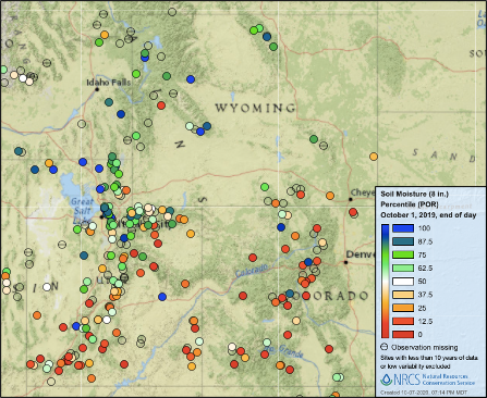
The 2020 water year was characterized by drier conditions and lower runoff than the drought-busting, high snowfall year that preceded. High 2019 seasonal runoff volumes left regional reservoir storage above average; reservoir storage at the beginning of the 2020 water year was 109% of average in Colorado, 127% of average in Utah and above average in Wyoming. Despite high snowfall and above average precipitation in the 2019 water year, June – September precipitation was much below average for most of the region. This left regional soil moisture values much below normal at the beginning of the 2020 water year. In northern Utah and the Upper Green River basin in Wyoming, soils were wetter than other locations, but still below average. Soil moisture values in southern Utah and western Colorado were much below average (<25th percentile).
-
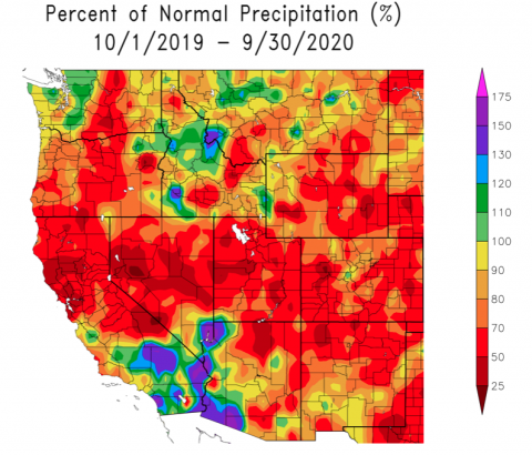
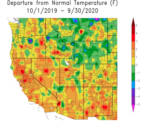
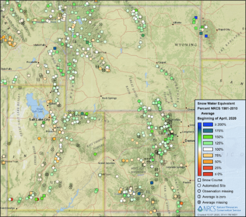
Total precipitation for the 2020 water year was below normal with much of the region seeing less than 70% of normal precipitation. Western Wyoming was the one location in the region that received near-normal precipitation. Water year average temperatures were a mix of slightly-above and slightly-below normal. In Wyoming, temperatures were 1-3°F below normal, while temperatures in much of Colorado were with 1°F of normal. Along the Wasatch Front and in central Utah, temperatures were 1-2°F above normal. Significant snowfall began during October in portions of the Colorado Rockies; accumulating snows for the remainder of the region began in November when much of the region, especially southern Utah, received much-above average snowfall. By April 1st, 2020, snow water equivalent (SWE) was near normal for most SNOTEL sites in the region. Central and northern Colorado saw the greatest regional snowfall where many sites had 125 – 150% of average SWE on April 1st.
-
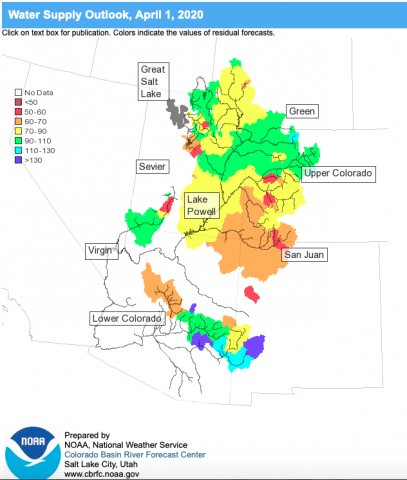
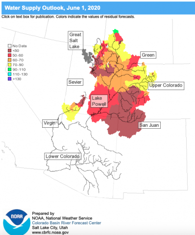
On April 1st, the Colorado Basin River Forecast Center forecasted near normal seasonal runoff volumes for the Upper Colorado, Upper Green, Bear, Yampa and White Rivers. Other locations in the Great and Upper Colorado River basins were forecasted to see below normal runoff (60-90% average). As of April 1st, seasonal runoff forecasts were lower relative to average compared to SWE values. For example, SNOTEL sites along the Upper Colorado River were 125-150% of average on April 1st, but the seasonal runoff volume was forecasted at 90-110% of normal. This is referred to as an inefficient runoff, where above normal SWE does not translate into above normal runoff. The forecast of a relatively inefficient runoff in 2020 was in part caused by very low soil moisture values before snow began to accumulate in October - November 2019. Seasonal runoff volumes in 2020 turned out to be much lower than originally forecasted in April. The June 2020 water supply outlook, which is very close to the actual seasonal runoff volume, forecasted below to much-below normal runoff for the Great and Upper Colorado River basins. Except for the Mainstem Colorado, Upper Green and Yampa River basins, seasonal runoff volumes in the Upper Colorado River and Great Basins were less than 60% of normal.
-
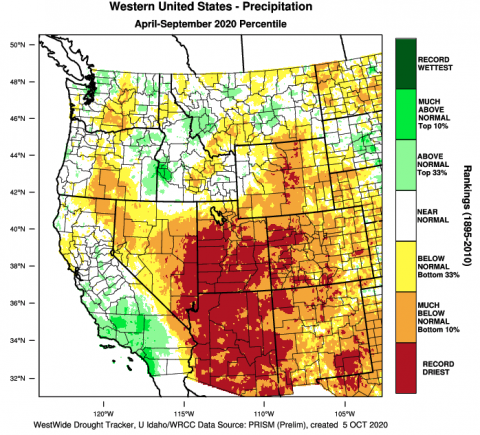
The dramatic change in seasonal runoff forecasts from April to June 2020 was caused by extremely warm and dry conditions in April – June 2020. Snow typically continues to accumulate at the higher elevations in April and May, but in 2020, warm and dry conditions melted existing snowpack at a faster rate and little additional snow accumulated in the region after April 1st. Dry conditions continued through the remainder of the water year. Much of Utah and portions of western Colorado and central Wyoming saw the driest April – September period on record. April – September 2020 precipitation was in the bottom 10% of years for nearly all of Colorado and Utah and over half of Wyoming. Although temperatures averaged over the entire 2020 water year were generally near average, April – September 2020 temperatures were much above normal (hottest 10% of years since 1895) for most of Utah and the western two-thirds of Colorado.
-
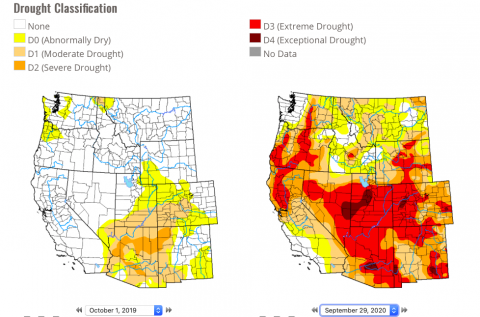
The combination of low water-year precipitation and much above average temperatures since April caused a significant expansion and intensification of drought in the second half of the water year. On October 1st 2019, drought conditions covered only a portion of southern Utah and southwestern Colorado, with D0 conditions covering additional area in eastern Utah, southwestern Wyoming and Colorado. By the end of the 2020 water year, the entire region was under drought conditions (>D1) except for a small portion of northern Wyoming. As of October 6th, 2020, D3 drought covers 46% of the three state region and D4 drought covers 10% of the region. Over the last 20 years of US Drought Monitor data, the current drought is one of the worst on record, in terms of regional coverage and severity. Current drought conditions are slightly more severe than in October of 2012 and 2018, but not as severe as the 2002 drought. In October 2002, D3 drought covered 63% of the region and D4 drought covered 19% of the region.
