September 5, 2013
Highlights
- Short-term drought has been relieved across most of Colorado and southern Utah; long-term drought conditions have also improved in many areas of Colorado, with less improvement in Utah and Wyoming.
- August precipitation was very mixed over the region, with Colorado and southern Utah generally wetter than average, and Wyoming and northern Utah drier than average
- The very low inflows into Lake Powell this water year, and resulting reservoir levels, are triggering a less-than-typical release from Powell to the Lower Basin in water year 2014.
- The NOAA CPC climate outlooks show a wet tilt for much of Utah and Colorado for the month of September, and a wet tilt for far northern Wyoming for the fall period.
Click on the thumbnail images in the text below to bring up the full-sized graphic
August Precipitation and Temperatures, and Current Drought
Throughout August, the monsoon continued to bring subtropical moisture into the region, but the results were more spotty than in July. Much of Colorado, southern Utah, and far northeastern Wyoming were wetter than average, but northern Utah and the rest of Wyoming were drier than average. The southern Front Range including Colorado Springs saw 5–8" of rainfall for the month, with some locations seeing about half of their annual average. Conversely, parts of far northern Utah and central and northern Wyoming had less than 25% of average precipitation, and these same areas were also very dry in July. With one month left in the water year, the HPRCC Water Year Precipitation map still shows only isolated parts of the region with above-average precipitation since October 1.
As in July, the temperatures in Augustwere warmer than average across most of the region, except in parts of southern Utah and western Colorado. Most areas were 1–4°F above monthly average temperatures for August. Salt Lake City was again the hot spot, capping off its hottest summer (June–August) ever with a record-hot August 2013 which averaged 82.7°F (5.7°F above average).
Many of the areas that were wetter-than-average during August have improved by one or two categories in the latest US Drought Monitor representing conditions as of September 3. The largest areas of improvement are in northeastern Colorado (to D1) and southeastern Colorado (to D2/D3). In Wyoming there were smaller areas of improvement in the northeastern and southeastern corners, while D1 expanded slightly in the northwestern corner. In Utah, there was an expansion of D2 in the northwestern part of the state. Overall, drought conditions across the region are similar to where they were at the beginning of June, with improvement in Colorado balanced by drying in Utah and Wyoming.
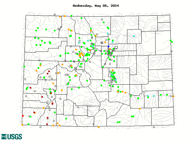
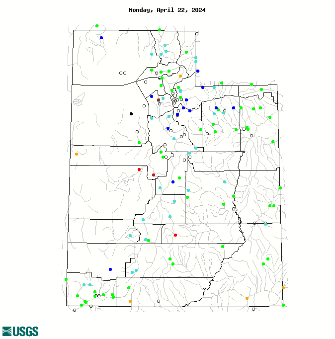
Current Streamflows
The maps of current streamflows across Colorado and Utah, show more gages in the "normal" (green) and above-normal categories, compared to one month ago. In Wyoming, however, there has been no improvement since early August, and below-normal gages still outnumber the normal and above-normal gages. The Colorado River near the CO-UT state Line was in the 41st percentile (95% of median flow) on September 4, very similar to early August.
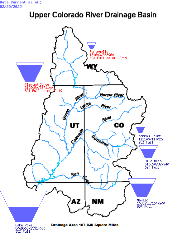
The Bureau of Reclamation's latest forecast for unregulated water-year 2013 inflows to Lake Powell is 4.3 MAF (40% of average). This would make 2000-2013 the driest 14-year period on record, averaging 8.2 MAF compared to the 1981–2010 mean of 10.8 MAF.
Reservoir Storage
At this time of year, the region's reservoirs are typically slipping towards their winter-early spring low stands. On August 31, Lake Powell held 10.79 MAF (44% full), down from 14.15 MAF (58% full) on the same day last year.
According to Reclamation's 24-Month Study Report released August 16, the level of Lake Powell is forecasted to fall just below 3575' by January 1, 2014', which, in combination with Lake Mead being above 1025', triggers the Mid-Elevation Release Tier, in which 7.48 MAF would be released from Powell in water year 2014. This would likely be the first release of less than 8 MAF since Lake Powell first filled in the early 1980s.
Seasonal Climate and Drought Forecasts
The latest monthly Climate Outlooks released on August 31 by NOAA CPC show a slight wet tilt for precipitation for September covering most of Utah and the western two-thirds of Colorado. The seasonal outlooks released August show a tilt towards wetter conditions in far northern Wyoming, but no tilt elsewhere in the region, for the and September–November and October–December periods . The CPC Climate Outlooks once again show enhanced odds for above-normal temperatures for the upcoming seasons, consistent with long-term warming trends. The latest CPC Seasonal Drought Outlook released August 15 projects that drought conditions will persist for most of our region through November, but further improvement is expected in south-central Coloradoup through the Front Range over the next three months.
As reported in the previous briefing: The PSD Precipitation Forecast Guidance ("SWcast") released July 12 for July–September 2013 conditions, shows a wet tilt for the period for eastern Colorado, and a stronger dry tilt for the northern Front Range, similar to the previous forecast for this period issued in May. Both of the regions showing tilt have shown modest positive forecast skill for the late-summer/early fall over the last decade. No tilt is forecasted for the rest of Colorado and Utah, indicating equal chances for wet, dry, and middle outcomes.
ENSO indicators continue to show ENSO-neutral conditions, as they have since last fall. The models in IRI's mid-August ENSO Prediction Plume again indicate a consensus towards ENSO-neutral conditions continuing through the fall and early winter, with the dynamical models tending towards the warm side of neutral, and the statistical models tending to stay on the cool side. The model envelope suggests some chance of weak El Niño or La Niña conditions developing this winter.