September 15, 2020 (UT, WY, CO)
-
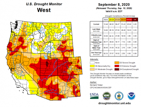
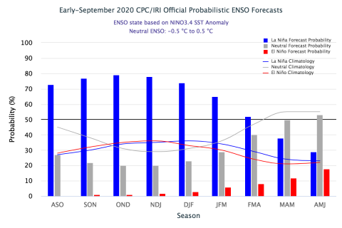
Record hot temperatures and near-record to record low precipitation during August led to a major degradation of drought conditions. D3 drought expanded to cover nearly 80% of Utah, 50% of Colorado and 20% of Wyoming. D4 drought emerged in central Utah and eastern Colorado. Two large wildfires burned in Colorado during August and are now the 1st and 5th largest wildfires in state history. La Niña conditions currently exist in the eastern Pacific Ocean and there is a 75% chance of La Niña conditions continuing through the fall and winter.
-
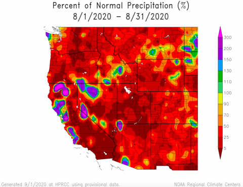
Throughout most of Colorado, Utah and Wyoming, August precipitation was less than 50% of normal. Nearly all of Utah and half of Wyoming received less than 25% of normal precipitation. A significant portion of Utah received less than 5% of normal precipitation. The northern Front Range of Colorado, and north-central Wyoming received 50 – 90% of normal precipitation and four locations throughout the region received above-average precipitation from isolated storms.
-
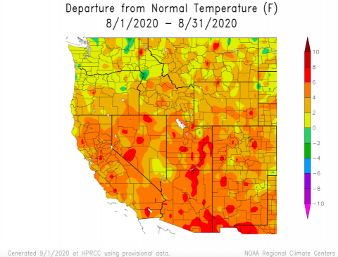
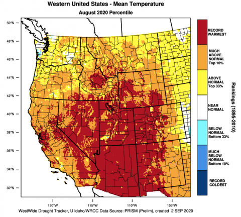
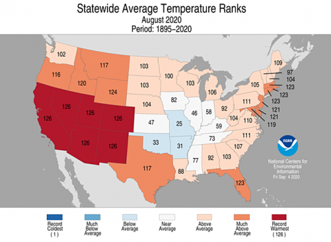
Temperatures were above normal for the entire region during August. Regionally, Utah experienced the warmest conditions with temperatures 4 – 6 degrees above normal for much of the state and portions of eastern and central Utah saw temperatures that were 6 – 8 degrees above normal. Temperatures were generally 2 – 4 degrees above normal in Colorado and Wyoming. Temperatures were 4 – 6 degrees above normal in western Colorado and along the Front Range. The hottest August temperatures on record were observed in nearly half of the Intermountain West, including Denver, Grand Junction and Salt Lake City.
-
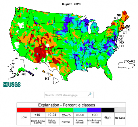
Streamflow in nearly all river basins in Colorado and Utah were below normal during August. August streamflow for much of Wyoming was near-normal (25 – 75th percentile), but basins in southern and western Wyoming were below normal (< 25th percentile). Despite low regional runoff volumes in 2020 and persistent drought, reservoir storage remains relatively high. Statewide, reservoirs in Utah are at 67% capacity and 109% of average levels and reservoirs in Colorado are 51% full and 83% of average storage levels. In Wyoming, current reservoir storage levels are general above average. Storage on large reservoirs in the Colorado River basin is variable with Flaming Gorge Reservoir relatively full (86% capacity, 100% of average), Navajo Reservoir slightly below normal (71% capacity, 86% of average) and Lake Powell half-empty (48% capacity, 63% of average).
-
A record hot August and extremely low precipitation caused a significant worsening of drought conditions throughout the region during August. D3 drought expanded across the entire region, especially in Utah (D3 covers 80% of state) and Colorado (D3 covers 50% of state). In Wyoming, D3 drought expanded to cover 21% of the state; western Wyoming is the only portion of the region not experiencing drought conditions. D4, the worst category of drought, emerged in central Utah and eastern Colorado. There was a one category improvement in drought conditions in central and southeastern Colorado; these two areas are now in D1 drought.
-
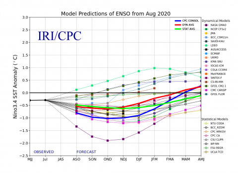
A La Niña Advisory was issued by the NOAA Climate Prediction Center on September 10th. La Niña conditions currently exist and there is a 75% probability of La Niña conditions continuing through fall and winter. As of early September, sea surface temperatures and atmospheric variables indicate La Niña conditions and the majority of Pacific Ocean temperature forecasts project a continuation of La Niña conditions through fall and early winter. The official CPC/IRI ENSO forecast is calling for a 75% chance of La Niña conditions during fall and winter. By spring, there is an increasing probability of neutral ENSO conditions. On a shorter timescale, the NOAA monthly climate outlooks show an increased probability for above average temperatures and below average precipitation for most of the region. The NOAA seasonal climate outlook (3 month timescale) indicates a higher probability for above average temperatures for the entire region and below average precipitation for Colorado and Utah.
-
Significant August weather event. Record heat, low precipitation, worsening drought and large wildfires were all significant events on a regional scale during August. August was the hottest on record for the entire southwestern United States, including Colorado, Utah, Arizona, California, Nevada and New Mexico. August 2020 was the driest on record for Utah and the fifth driest on record for Colorado and Wyoming. Hot and dry conditions during August caused rapid degradation of drought conditions and extreme drought (D3) now covers approximately half of the three state region. Several significant wildfires began burning in Colorado during August. The Pine Gulch fire, north of Grand Junction, CO, is 95% contained (9/10/20) but burned 139,000 acres and is the largest wildfire in state history. The Cameron Peak fire has burned 102,000 acres as of 9/10/20 and is currently the fifth largest fire in state history. Up to 14” of snow fell on the fire on 9/8/20, but the fire is only 4% contained (9/10/20) and still remains a threat as warm conditions return to the region.
