October 13, 2020 (UT, WY, CO)
-
Continued below average precipitation during September caused further worsening of drought conditions; extreme (D3) drought covers 46% and exceptional drought covers 10% (D4) of the region. Entering the 2021 water year, the current regional drought ranks among the worst in the last 20 years (2002, 2012, 2018). La Niña conditions currently exist and there is a 70-80% probability of La Niña conditions persisting through early winter. Drought conditions are expected to persist and potentially worsen as there is an elevated probability for below normal precipitation and above normal temperatures for the next three months.
-
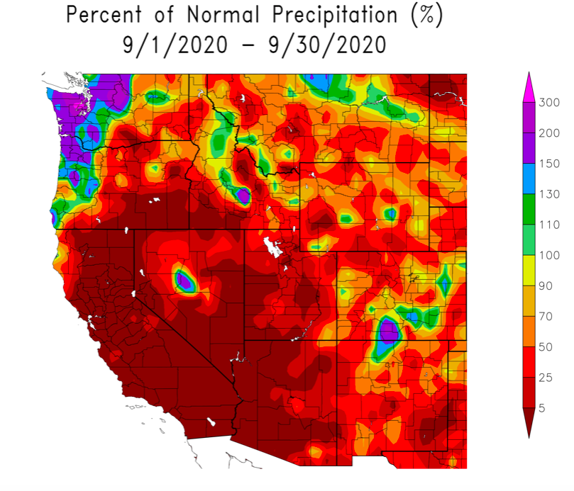
Most of Colorado, Utah and Wyoming experienced below average precipitation during September. The driest conditions occurred in Utah, where nearly the entire state received less than 25% of normal precipitation. September precipitation in Wyoming was below average with the driest conditions found in southern and western Wyoming. In Colorado, September precipitation ranged from near-average to much-below average. Isolated storms brought average to slightly-above average precipitation to several locations in central Wyoming and southern and eastern Colorado. Precipitation during July – September was very low;. July – September 2020 was the driest on record for areas of eastern Utah, northwestern Colorado and central Wyoming. Precipitation was much below normal (driest 10% of years since 1895) for nearly the entire region.
Image Image
Image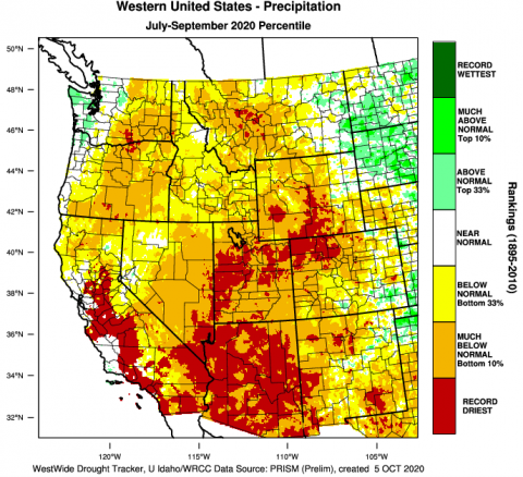
-
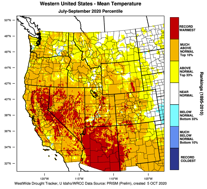
Temperatures cooled relative to normal in September compared to previous months. Except for a few isolated locations, September temperatures were within two degrees of normal in Colorado and Wyoming, and in eastern Utah and parts of central Utah. Along the Wasatch Front and in southwestern Utah, September temperatures were 2-4 degrees above normal. Temperatures during July – September were generally much above average, with most of Utah, Colorado and western Wyoming seeing temperatures that were in the top 10% of hottest July – September periods since 1895. Several locations in all three states, especially in southern Utah, saw the hottest July – Septembers on record.
Image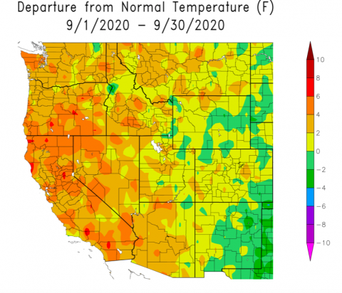 Image
Image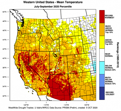
-
Streamflow in most regional river basins was below normal during September. Utah and western Colorado saw the lowest regional streamflow with most sites reporting below average (10 - 25th percentile) or much-below average (< 10th percentile) conditions. Some locations in northern Utah and along the mainstem of the Colorado and Arkansas Rivers saw near-normal (25th - 75th percentile) streamflow. Streamflow in Wyoming was a mix of below and near normal conditions during September. Regional reservoir storage remains relatively high as of October 1st, despite drought conditions across the entire region and low water year precipitation. On a statewide basis, reservoirs are at 82% of normal capacity in Colorado, 107% of normal capacity in Utah and generally above average capacity in Wyoming. Storage on large reservoirs in the Upper Colorado River Basin remains variable with Flaming Gorge Reservoir relatively full (85% capacity, 99% of average), Blue Mesa Reservoir below normal (53% capacity, 76% of average) and Lake Powell half-empty (47% capacity, 62% of average).
-
Drought conditions worsened in parts of Colorado and Utah during September. Some improvement to drought conditions occurred in western Wyoming and eastern Colorado. Colorado saw the greatest regional degradation in drought conditions during September; D4 drought emerged in western Colorado and D3 drought expanded slightly. Nearly all of Colorado is in D1 drought, 43% of the state is in D3, or extreme drought, and 17% of the state is in D4, or exceptional drought. A one category improvement in drought conditions occurred in some areas of eastern Colorado. In Utah, D4 drought expanded significantly in central Utah and two areas of D4 drought emerged in eastern Utah. D4 drought now covers 16% of Utah. D3 drought expanded northward slightly and a one category improvement in drought conditions occurred in northern Utah. Drought conditions in much of Wyoming remain unchanged, but a one category improvement in drought occurred in western Wyoming. Northwestern Wyoming remains the only portion of the region unaffected by drought.
Image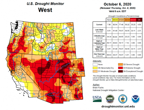
-
A major wildfire started in the Medicine Bow Mountains of southwestern Wyoming on September 17th. As of October 8th, the Mullen Fire burned 170, 996 acres in Wyoming and Colorado and was 14% contained. In August, the Pine Gulch Fire near Grand Junction, CO burned 151,000 acres, making it the largest fire in Colorado’s history.
-
During September, sea surface temperatures were below average in the eastern Pacific Ocean, indicating La Niña conditions. Most models for Pacific Ocean temperatures forecast below normal ocean temperatures during fall and early winter. Early October ENSO forecasts predict a 90% probability of La Niña conditions through early winter and above a 60% probability of La Niña conditions through late winter to early spring. On the one-month timescale, there is an increased probability for below normal precipitation for the entire region, with a greater chance of reduced precipitation in the eastern portion of the region. On the three-month timescale, there is a slight increase in the probability of below normal precipitation for the southern half of Utah and most of Colorado, largely due to the influence of La Niña conditions. On one-month and three-month timescales, there is an increased probability of above average temperatures for the entire region.
Image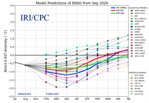 Image
Image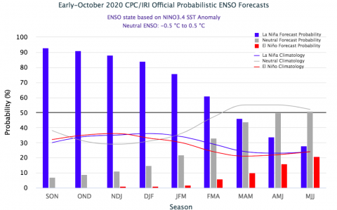 Image
Image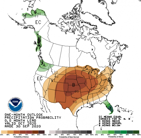 Image
Image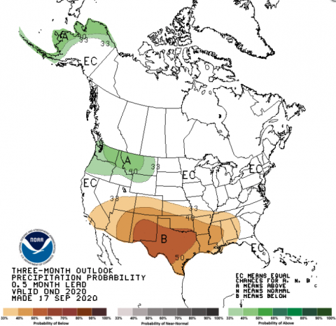
-
Significant September weather event. On September 8th, a strong upper-level low pressure system brought a sharp cold front to the region, which caused extremely cold temperatures, snow and high winds from the Front Range of Colorado to the Wasatch Front and further west into Oregon and Washington. Prior to the storm, much of the region experienced record to near-record temperatures in the 90s and low 100s. On September 8th, Denver, CO reported 1” of snow, the second earliest snowfall and a record low temperature of 31°F. Up to 9” of snow fell in the foothills of the Front Range and 5.6” of snow was measured in Boulder. In Wyoming, as much as 12” of snow fell in Centennial and a record 1.1” of snow fell in Cheyenne which tied the earliest snowfall for Cheyenne. Along the Wasatch Front, the storm caused a significant downslope wind event, in which winds blow from the east and accelerate as they travel down the western slope of the Wasatch Mountains. Wind gusts reached 89 mph at the University of Utah and 77 mph at the airport in Salt Lake City. The highest recorded wind speed was 99 mph in Farmington. This wind event differed from many Wasatch Front downslope wind events because the high winds extended much further west from the mountains than is typical. The storm downed thousands of mature trees, damaged powerlines and structures, closed roads and caused power outages for 180,000 customers. Strong easterly winds also occurred on the west slope of the Cascade Mountains in Oregon and Washington and led to the explosive growth of several large wildfires.