November 12, 2020 (UT, WY, CO)
-
Drought continued to dominate regional climate in October. Precipitation was below normal to much-below normal for most of the region. Snow fell in most mountain ranges during October, but drought conditions persisted or worsened, especially in Utah and Colorado. Another large wildfire broke out in Colorado; by the end of the month the East Troublesome Fire scorched over 193,000 acres and the Cameron Peak Fire had grown to over 208,000 acres. La Niña conditions are forecasted for November – March, increasing the probability of below average winter precipitation for much of Utah and Colorado and above average winter precipitation in northern Wyoming.
-
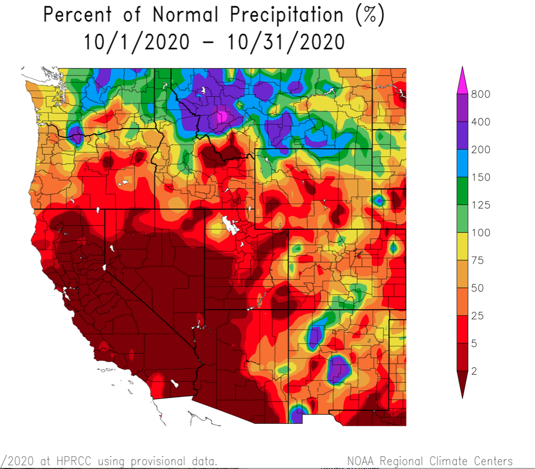
The 2021 water year started no better than the 2020 water year finished. October precipitation was much below normal for much of the region. Utah again saw the least regional precipitation with much of the state receiving less than 25% of normal October precipitation. October precipitation was less than 50% of normal for most of Colorado. Central and southern Wyoming received 5 – 50% of normal precipitation but above normal precipitation fell in northern Wyoming.
Image
-
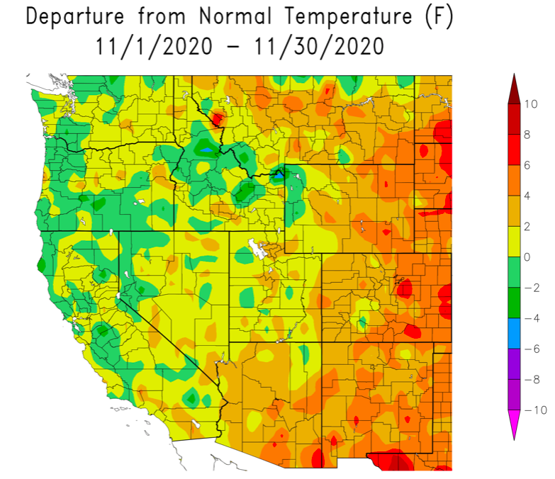
October temperatures were a mix of above and below normal. Temperatures were generally 2 – 4 degrees above normal in the southwestern portion of the region and 2 – 6 degrees below normal in the northeastern portion of the region. Near-normal October temperatures occurred in large portions of Colorado, Wyoming and northern Utah.
Image
-
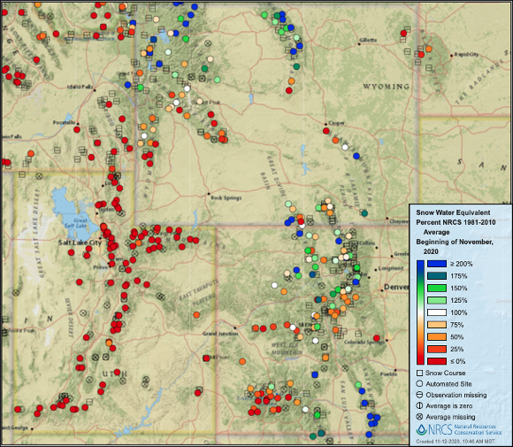
Snow fell during October in nearly all regional mountain ranges, but snow water equivalent (SWE) as of November 1st is below normal for most parts of the region, especially Utah and southwestern Colorado and Wyoming. Above average SWE conditions are found in northern Wyoming and parts of Colorado. Most of the region’s October snowfall was received during two storms on October 11-12 and 24-26.
Image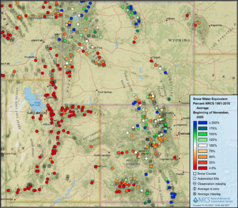
-
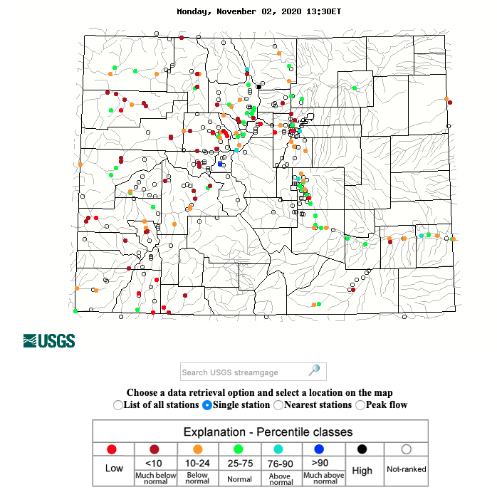
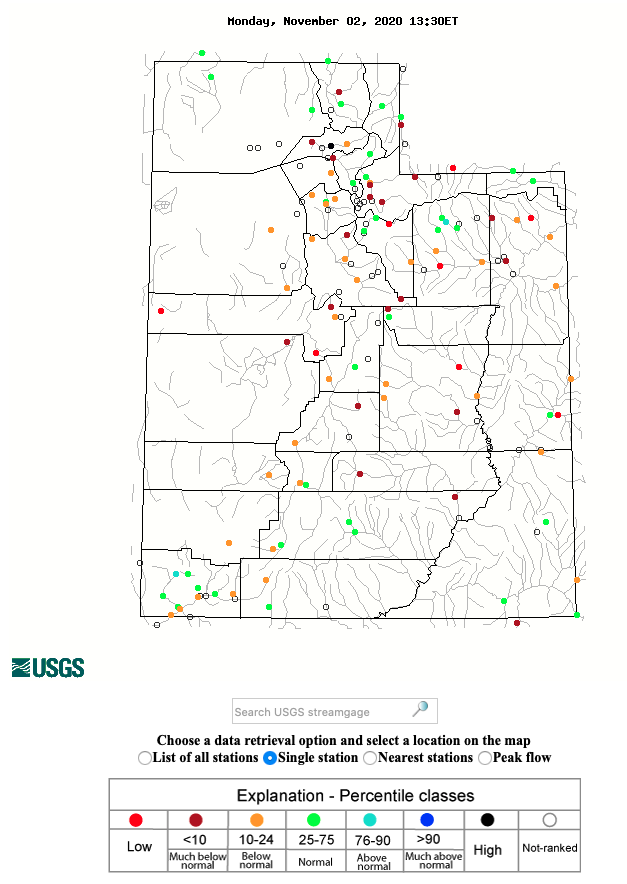
Streamflow in the majority of regional river basins was below normal, especially in Colorado and Utah. Gages at eighteen USGS streamflow monitoring sites reported record low flows, including the Provo and Price Rivers in Utah and the Animas, San Miguel, Piedras and Los Pines Rivers and Beaver, Clear and Gore Creeks in Colorado. Extremely low to record-low streamflow at many locations is a sign of low precipitation and soil moisture contributing to extreme drought. In Wyoming, streamflow at the majority of monitoring sites was near normal, except in southwestern Wyoming. Reservoir conditions changed little in October with regional reservoir storage at 82% of average in Colorado, 105% in Utah and near-normal in Wyoming.
Image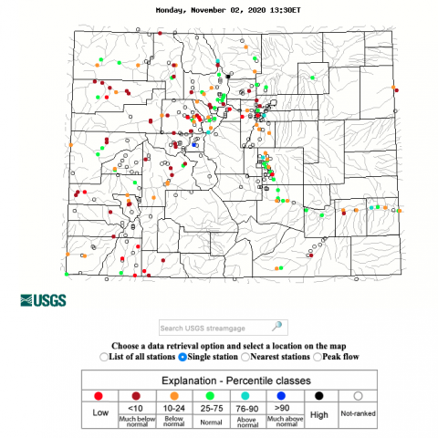 Image
Image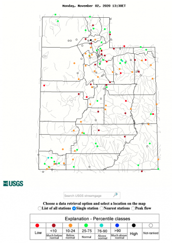
-
The entire region remains in drought except for northwestern Wyoming, and drought conditions worsened in some parts of Utah and Colorado despite October snowfall throughout the region. D3 drought conditions expanded slightly in eastern Colorado and north-central Wyoming. D4 conditions also expanded to include south-central Utah and a larger area in western Colorado. Extreme drought conditions (D3) cover 61% of the region with conditions worst in Utah (87% statewide coverage) and Colorado (74% statewide coverage). Exceptional drought (D4) currently covers 24% of Colorado and 28% of Utah.
Image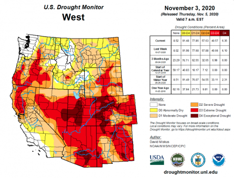
-
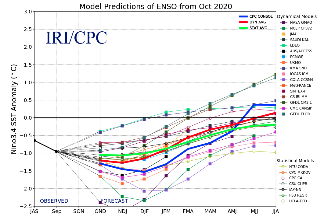
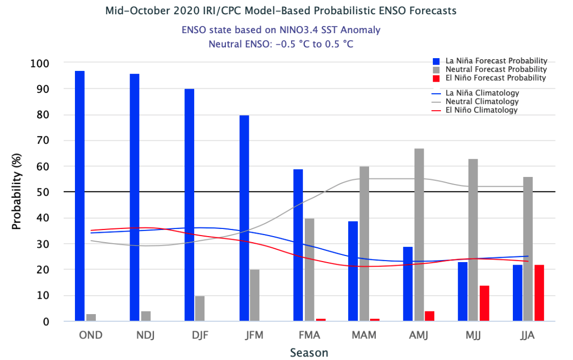
La Niña conditions were present during October with eastern Pacific Ocean temperatures around 1.5 degrees below normal. The most recent projections of ocean temperatures suggest that below normal ocean temperatures will persist through the winter with at least an 80% probability of La Niña continuing through March. Typical La Niña weather patterns are likely for the next several months with an increased probability of above average temperatures for the entire region on one and three month timescales and below average precipitation for the southern two-thirds of the region on one month and three month timescales. There is an increased probability of above average precipitation for northern Wyoming in November – January.
Image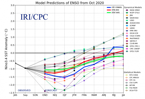 Image
Image Image
Image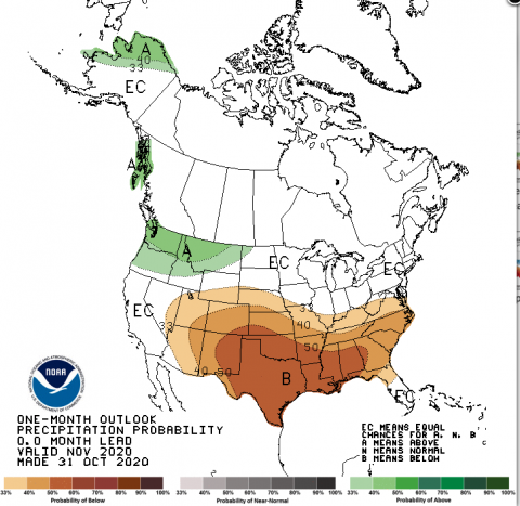 Image
Image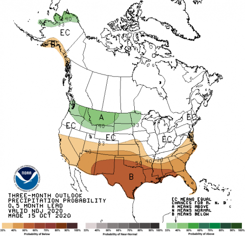
-
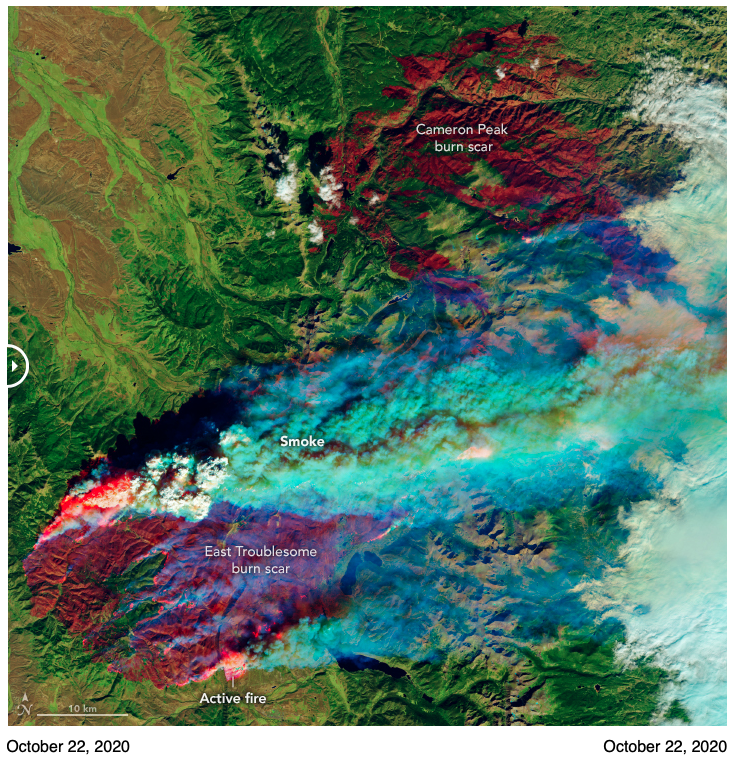
Significant October event. The historic 2020 fire season in Colorado worsened during October. The East Troublesome Fire in Grand County began on October 14th and grew modestly until the evening of October 21st. Over the next 24-hour period, driven by winds gusting to 50 mph and very low humidity, the fire grew explosively, burning 105,000 acres. The area burned by the East Troublesome Fire on 10/21 – 10/22, alone, would have made it the fifth largest in Colorado history. As of 11/8/20, the East Troublesome Fire burned 193,812 acres 250 structures and is 47% contained and is the second largest fire in Colorado history. The Cameron Peak fire continued its growth during October and is the largest in state history with a burned area of 208,913 acres, 461 structures destroyed and 92% contained as of 11/8/20. On October 25th, one to two feet of snow fell on both fires ending the East Troublesome Fire’s rapid growth and helping to significantly contain the Cameron Peak Fire. The three largest fires in Colorado state history all occurred during the 2020 fire season.
Image