March 14, 2014
Highlight
- February storm tracks favored the region’s mountains, especially in Wyoming and northern and central Colorado. Southern Utah and southern Colorado, and most lower-elevation areas, ended up drier than average. A similar pattern has continued into early March.
- As of March 13, snowpack conditions are near or above average over most of the region. Nearly all basins across Wyoming, and basins in northern Colorado, are at over 120% of median SWE. The basins below 90% of median SWE are in southern and central Utah, and south-central Colorado.
- The March 1 spring-summer streamflow forecasts call for most forecast points in Wyoming and northern and central Colorado to have above-average or much-above-average spring runoff. Most forecast points in south-central and southwestern Colorado, and in Utah south of the Wasatch Front, are expected to have below-average or much-below-average runoff.
- The watersheds in the northern Front Range of Colorado that were most affected by the floods last September have unusually large snowpacks, and there is a high risk of snowmelt flooding. With stream channels impacted by debris and excess sediment in many locations, the severity of flooding may be greater than in previous high-runoff years.
Click on the thumbnail images in the text below to bring up the full-sized graphic
February Precipitation and Temperatures, and Current Drought
As in January, precipitation in February was unevenly distributed across our region, with the storm tracks and dynamics generally favoring the high mountains as well as some adjacent areas to the east of the mountains. Areas with above-average to much-above-average precipitation included western and north-central Wyoming, southeastern Wyoming and portions of eastern Colorado, and the high mountains in Colorado and northern and central Utah . Central and south-central Wyoming, most of the lower-elevation areas of Colorado, and southern and northeastern Utah were drier than average. Overall, an active and consistent weather pattern persisted through the month and into early March, with repeated shots of Pacific moisture in the same locations with each passing low-pressure trough.
There was a striking pattern in temperature anomalies across the region in February . East of the Continental Divide in Wyoming and Colorado saw temperatures colder than average by 3–12°F, as repeated Arctic cold waves sloshed into those areas. West of the Divide, including all of Utah, temperatures were 3–9°F warmer than average. Worland, in central Wyoming, was 11.5°F below normal for the month, while about 300 miles away, Salt Lake City was 7.9°F above normal for the month, an almost 20-degree differential in the anomaly.
The latest US Drought Monitor, representing conditions as of March 11 , shows improvement since early February in areas of central and northeastern Colorado (from D0 to drought-free), central and northern Wyoming (from D1 to D0, and D2 to D1) and northern Utah (D2 to D1). The proportion of the region in D2 or worse drought changed little, with Utah nudged down from 13% to 11%, Colorado remaining at 14%, and Wyoming unchanged at zero.
Current Snowpack
The Current Basin Snowpack map from NRCS shows most of the region with near- to much-above-normal SWE. With the storm tracks since January favoring Wyoming and northern Colorado, those areas have about 120% of median SWE or greater, with over 140% of median SWE in western, north-central, and southeastern Wyoming, and northeastern Colorado. Conditions in northern Utah have improved considerably since February 1, with SWE now at 100–120% of median. Central and southern Utah, especially in the southwestern corner, have been drier and warmer the past two months and snowpacks are below-median (45–90%) and some have even started early melt. Southwestern and south-central Colorado are also lagging behind the basins to the north, at around 90% of median.
Current Streamflows
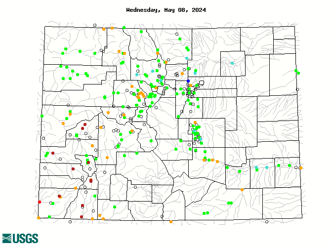
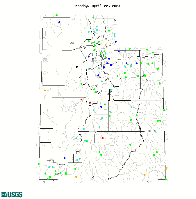
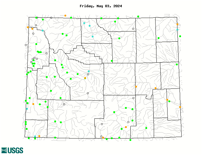
The maps of current streamflows for Colorado , Utah , and Wyoming show that the majority of Wyoming gages are ice-affected and have no data, while in Utah and Colorado many gages are now reporting. Of the gages that are reporting, flows are mainly normal or above normal Wyoming and Colorado, while they are mainly normal or below normal in Utah.
Spring-Summer Streamflow Forecasts
The Westwide Streamflow Forecast Map based on the NRCS March 1 forecasts shows that most forecast points in Wyoming and northern and central Colorado are expected to have above-average (110–129%) or much-above-average (130–149%) spring and summer runoff. Most forecast points in south-central and southwestern Colorado, and much of Utah, are expected to have below-average (70–89%) to much-below-average (50-69%) spring and summer runoff, with a handful of points expected to have far-below-average (25–49%) runoff, and two points in the under-25% category. Many points in northern Utah and west-central Colorado are expected to have near-average (90–109%) runoff.
The watersheds in the northern Front Range of Colorado that were most affected by the floods last September now have unusually large snowpacks, generally over 150% of median SWE for early March and above the 90th percentile. The NRCS March 1 forecasts for these basins call for above-average (110–129%) seasonal runoff. According to NOAA NWS, there is a high risk of minor snowmelt flooding in these basins. Since stream channels are impacted by debris and excess sediment in many locations in these basins, the risk and severity of flooding may be greater than in previous high-runoff years. Multiple state and federal agencies are cooperating to remove debris and sediment from these channels in preparation for high runoff.
IMPORTANT NOTE: While NRCS and NOAA continue to collaborate on streamflow forecasts, the forecast values are no longer being strictly coordinated between NRCS and some of the RFCs, including the CBRFC. For example, the NRCS March 1 forecast for Lake Powell April–July inflows is 7800 KAF, 109% of average. The NOAA CBRFC March 1 forecast for Lake Powell inflows is 8300 KAF, 116% of average.
Seasonal Climate and Drought Forecasts
The latest monthly Climate Outlook released on February 28th by NOAA CPC shows only a slight wet tilt in precipitation for far southern Utah and Colorado for March . The seasonal outlooks released February 20 show no tilt in precipitation for our region for the March–May and April–June periods. The latest CPC Seasonal Drought Outlook released February 20 projects that the areas of drought conditions (D1 or worse) in our region, in Utah and southeastern Colorado, will persist through at least May, but no additional drought development is expected.
As reported in the previous briefing, the PSD experimental April 1 SWE forecast for Colorado released in mid-January has the median (50th percentile) forecast calling for near or above-average April 1 snowpack (92–110% of average) for all basins, with the highest forecasted SWE in the Arkansas and Yampa-White basins, and the lowest SWE in the San Juan-San Miguel-Dolores and Rio Grande basins.
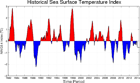
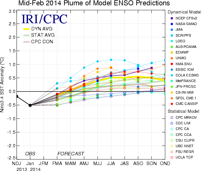
In the ENSO arena, we finally have a real prospect of change. While ENSO indicators are still showing ENSO-neutral conditions , the forecast models are increasingly pointing towards development of El Niño conditions. The IRI ENSO Prediction Plume for mid-February shows that starting in the mid-summer period (June–August) just under half of the models call for El Niño onset, with about half remaining in neutral territory. The early March update of NOAA CPC/IRI’s probabilistic forecast shows marginally higher likelihoods of El Niño development by summer, at or just above 50%.
Accordingly, NOAA CPC has hoisted an El Niño Watch, indicating that “conditions are favorable for the development of El Niño conditions within the next six months.” An experimental PSD regression-based MEI forecast issued March 10 projects a higher likelihood of El Niño development, at 64% probability for the July–September period.