March 10, 2021 (UT, WY, CO)
-
Above-average February precipitation in much of the region led to substantial increases in snowpack in northern Colorado, northern Utah and Wyoming. Despite gains in regional snowpack, March 1st seasonal runoff forecasts remain below to much-below normal except for locations east of the Continental Divide in Colorado and in Wyoming where forecasts are near to slightly-below average. Regional drought persisted during February, but improved by one drought category in parts of Colorado, Utah and Wyoming.
-
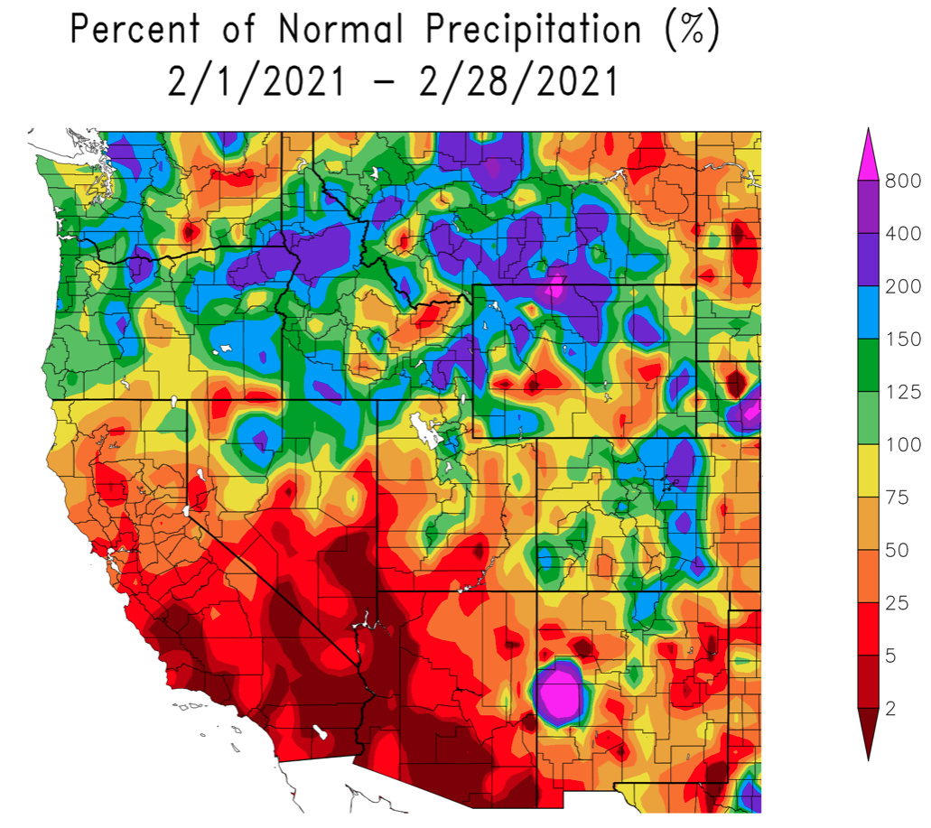
February precipitation was mostly near- to above-average. Almost all of Colorado saw at least 75% of normal precipitation and about half of the state saw 100-200% of normal precipitation. Areas along the eastern plains of Colorado received over 200% of normal precipitation. In Utah, strong storms in mid-February drove above average precipitation in the Wasatch Mountains and central Utah plateaus, but southern Utah saw dry conditions. Most of Wyoming received above average precipitation; large swaths of northern Wyoming received more than 200% of normal precipitation.
Image
-
Similar to November, there was a sharp regional pattern in temperature during February with cold temperatures to the northeast and warmer temperatures in the southwest portion of the region. Temperature were 6 to 15 degrees below normal in eastern Colorado and northeastern Wyoming. In the remainder of the region, February temperatures were near-normal with the warmest temperatures in Utah.
Image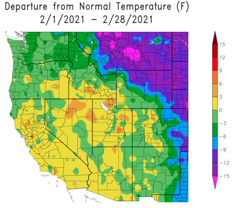
-
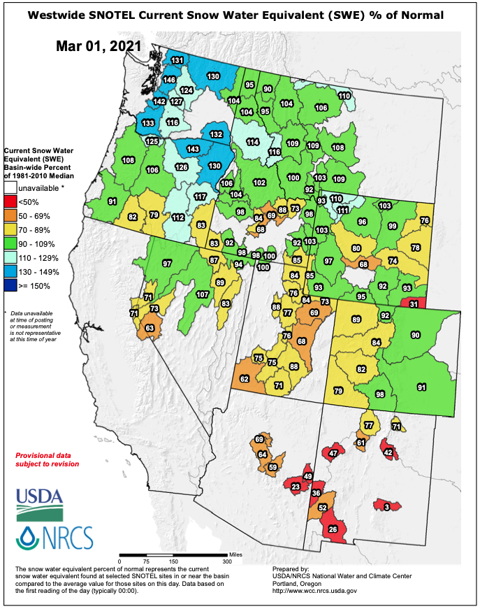
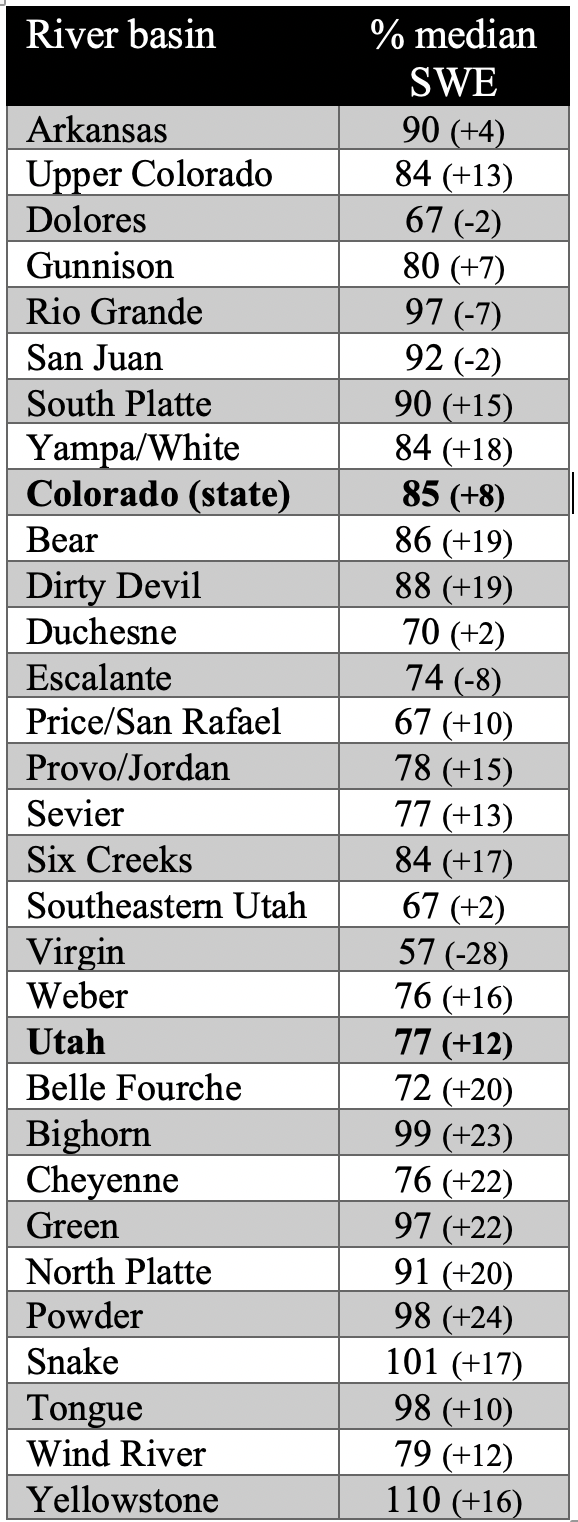
Strong storms during mid-February led to gains in snow-water equivalent (SWE) relative to average for much of the region. March 1st SWE conditions were near-normal east of the Continental Divide in Colorado and below normal on the Western Slope. Snowpack conditions in northern and central Utah improved significantly in February, but remained below normal across the state. March 1st SWE for many Wyoming river basins were near-normal with slightly above average SWE in northwestern Wyoming.
Image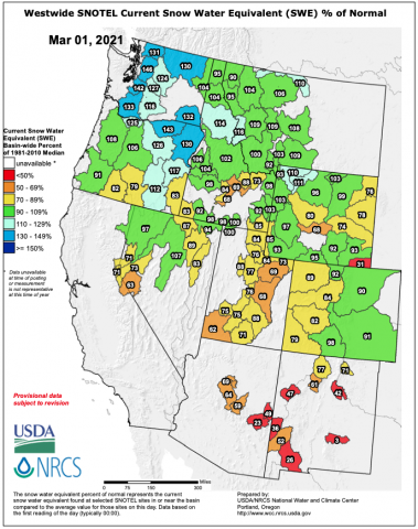 Image
Image
-
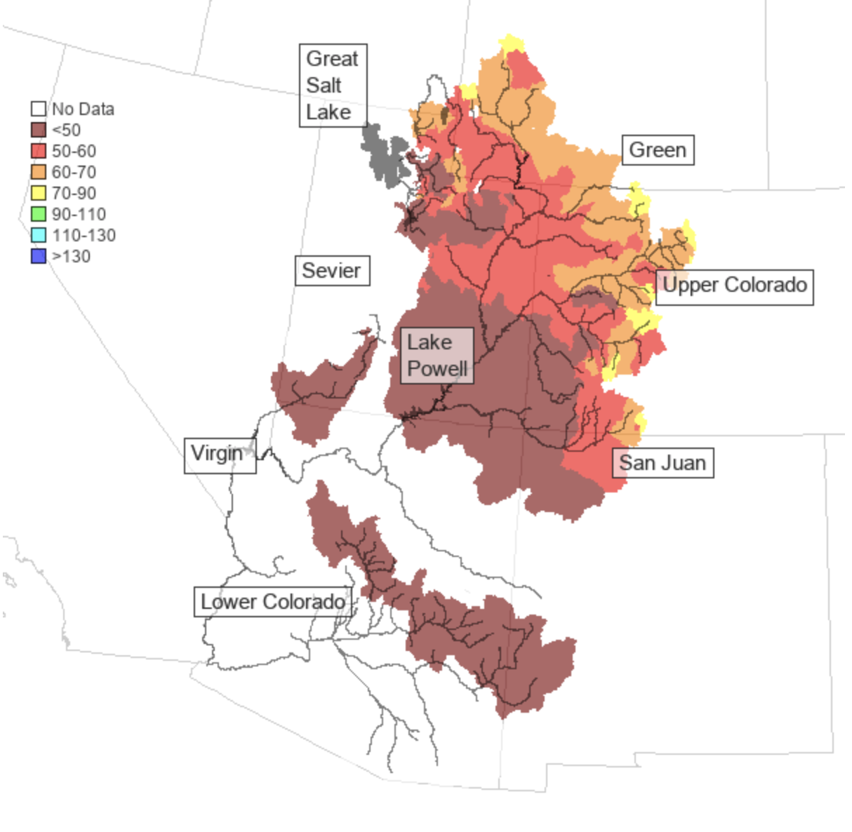
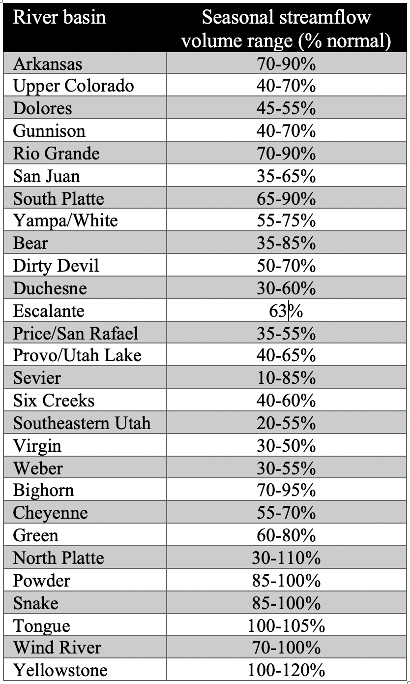
The NOAA CBRFC March 1st seasonal runoff forecasts for the Upper Colorado River basin were less than 70% of normal for nearly all portions of the basin. Small portions of the Upper Colorado and Green River basins were forecasted to have 70-80% of normal runoff. Seasonal runoff volume forecasts forthe Dolores, San Juan, Duchesne, and Virgin River basins were less than 60% of average. In the Great Basin, seasonal runoff forecasts were generally less than 60% of average. East of the Continental Divide, higher, but still below-average seasonal runoffs were forecasted for the Arkansas, South Platte and Rio Grande River basins. In Wyoming, near- to above-average seasonal runoff volumes were forecasted for the Powder, Snake, Tongue and Yellowstone Rivers.
Image Image
Image Image
Image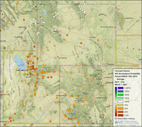
-
Regional drought persisted during February, but a one category improvement in drought conditions occurred in many locations. Extreme (D3) or Exceptional (D4) drought covers 54% of the region, a 9% decrease since January. Locations in western to central Colorado, the Wasatch Mountains, central Utah plateaus and northern Wyoming experienced a one category improvement in drought conditions. Record low February streamflow conditions were observed at Utah sites along the American Fork, Duchesne, North Fork Virgin, Provo and White Rivers and at Colorado sites along the Animas, Mancos and San Juan Rivers.
Image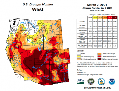
-
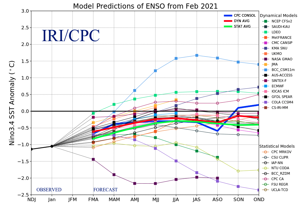
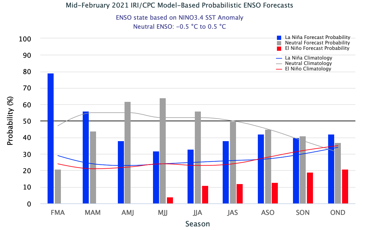
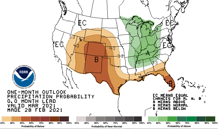
La Niña conditions are weakening and are expected to shift to a neutral ENSO phase by late spring to early summer. By April, there is a 60% chance of neutral ENSO conditions. There is an increased chance of below normal precipitation for most of the region on the one- and three-month timescales, especially for Colorado during March. During March, there is a higher probability of above average temperatures in Colorado. The three-month forecast for temperature predicts an increased probability of above average temperatures for the entire region, especially in southern Colorado and southeastern Utah.
Image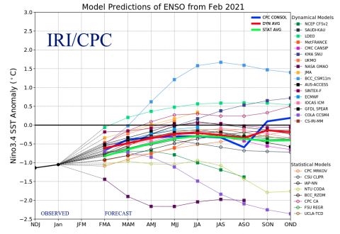 Image
Image Image
Image Image
Image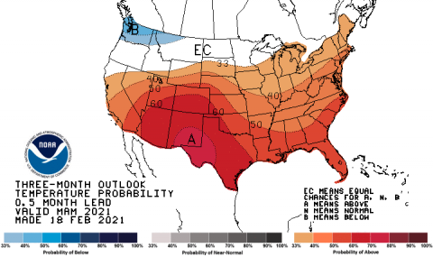
-
Significant February weather event. A potent storm cycle delivered much-needed snow to northern Utah in mid-February. From February 11-18, northern Utah received 3-6” of snow-water equivalent from the Bear River Range near Logan south to the Cottonwood Canyons in the Central Wasatch. While not a quite drought-breaking storm, snow-water equivalent increased in the Bear, Provo, Six Creeks and Weber River basins by 15-20% relative to average during February. During this time period, Alta Ski Area received 103” of snow, including 65” over the last 4 days of the storm cycle. Utah Highway 210 in Little Cottonwood Canyon was closed for nearly 3 days due to extreme avalanche danger and 34 avalanches crossed the road. Avalanches occurred on many avalanche paths that had not run since 1984 and one avalanche pushed a plow truck off Highway 210.