June 10, 2020 (UT, WY, CO)
- Continued dry and warm conditions in the Intermountain West during May have caused a rapid melt of snowpack and a reduction in June 1st streamflow forecasts compared to May 1st forecasts. Much below average precipitation (5-50% of normal) and above average temperatures in Utah and southern Colorado have caused snowpack at many Snotel sites to melt out 10 days to one month earlier than average. June 1st seasonal streamflow forecasts have decreased by as much as 20% since May 1st and the streamflow forecast for the inflow to Lake Powell on the Colorado River decreased by 750,000 acre-feet to 57% of average. Abnormally dry and drought conditions expanded in all three states, now covering 80% of the region.
-
During May, precipitation was below normal for the entire region except for a small area in northwest Wyoming and along the Colorado-Wyoming border . Nearly all of Utah received less than 50% of normal May precipitation, and over half the state received less than 25% of normal precipitation. May 2020 was the 7th driest May on record in Utah. Central Wyoming, western and southern Colorado also received less than 50% of normal May precipitation. The eastern plains and the Front Range of Colorado fared better, with most areas receiving 70-90% of normal precipitation.
May temperatures were above average for the entire region except northeastern Wyoming . Nearly all of Utah and Colorado experienced conditions that were 2-4 degrees above normal and portions of eastern Utah and western and southern Colorado saw temperatures that were up to 6 degrees above normal. Average May temperatures in both Colorado and Utah were in the top ten highest May temperatures since 1895. Temperatures were generally above average, but within two degrees of normal for most of Wyoming.
- Snowmelt proceeded rapidly, due to below normal precipitation and above normal temperatures in April and May, for the entire region except for the Upper Green, Snake and Yellowstone River basins in northwest Wyoming. All of Utah, southwestern Colorado and southwestern Wyoming have extremely low snowpack with the Snotel sites in the Sevier, Rio Grande and Weber River basins entirely melted out . As of June 1st, only seven Snotel sites in Utah still have snow. Also in Utah, snow at Snotel sites melted out 10 days earlier than normal in the San Rafael and Upper Weber River basins, 16 days early in the Ogden River basin and 21 days early in the Upper Sevier River basin. While some snow still persists in the highest elevations of Dolores and San Juan River basins, snowmelt is proceeding about 3 weeks ahead of normal. Snow at Snotel sites in the Rio Grande River basin is gone and melted out a full month early. Elsewhere in Colorado, the snowpack is melting out faster than normal, but persisting better than other basins in the region, especially in the Arkansas and Yampa River basins. Wyoming’s snowpack varies greatly, with several basins nearly melted out and several basins at near-to-above normal conditions.
- The NOAA CBRFC June 1st seasonal runoff forecasts for the Upper Colorado River Basin and the Great Basin are below to much-below average . Seasonal runoff forecasts decreased by 5-20% compared to the May 1st forecasts for many basins. Basins with closer to normal seasonal runoff forecasts include the Upper Colorado, Upper Duchesne, Upper Green and Yampa River basins. Seasonal runoff forecasts in Utah 40-85% of average for river basins along the Wasatch Front, 45-90% of average in river basins draining the Uinta Mountains and 40-75% of average for basins in central Utah. Regionally, the lowest seasonal runoff is forecasted for southwestern Colorado in the Dolores, Gunnison and San Juan River basins where runoff forecasts range from 25 – 65% of average. The mainstem of the Colorado River and its tributaries have near to slightly-below normal seasonal runoff forecasts. The inflow to Lake Powell on the Colorado River is forecasted to be 4.1 million acre-feet (57% average), a decrease of three-quarters of a million acre-feet since the May 1st forecast. NRCS does not produce June 1st seasonal runoff forecasts for all basins in the region ; June 1st seasonal runoff forecasts for both the South Platte and Arkansas River basins are below normal (60-70% of average). Below-normal seasonal runoff forecasts throughout the region are mainly due to climate anomalies at the beginning and end of the snow-covered season: low soil moisture in fall 2019 and low precipitation and warm temperatures in April and May.
- Some expansion of drought occurred in Colorado, Utah and Wyoming during May; drought conditions did not improve for any location within the region . Moderate expansions of drought occurred in both Colorado and Utah where abnormal dryness and drought (D0-D3) now cover 76% and 91% of the states, respectively. In Colorado, D3 drought in southern and eastern Colorado expanded and D0-D1 drought expanded northward in central Colorado. Utah experienced the most significant expansion of drought during May. Continued low precipitation in central and northern Utah, where precipitation was 5–50% of normal for both one- and two-month timeframes, led to the expansion of D1 drought into all of northern Utah and D2 drought expansion westward in central Utah and northward along the Wasatch Front. D2 drought also significantly expanded in southeastern Utah, now covering all of San Juan County and a portion of Grand County. In Wyoming, the coverage of D0 greatly expanded from 17% to 72% in the past month, while D1 drought now covers 2% of the state’s area. Overall, abnormal dryness or drought covers nearly 80% of the Intermountain West.
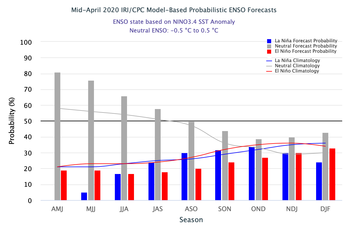
- During May, Pacific Ocean temperatures continued to slowly cool and were only slightly above normal (0.2° - 0.4°C) . Sea surface temperatures are projected to cool to average or slightly below average throughout the summer . ENSO is likely to remain in its neutral phase through the summer (50-90% probability), but by fall, there are near-equal chances of a positive, negative or neutral ENSO phase . The NOAA one-month temperature outlook for June shows a strong tilt towards above average temperatures for all of Utah, much of Colorado and southwest Wyoming . There are equal chances of above or below normal precipitation for the next month. Over the next three months (June–August) temperatures are likely to be above average for the entire region . There is a slight tilt towards below-average precipitation for much of the region during the June-August period .
- Significant weather event for May. Similar to the end of April in the Intermountain West, May ended with a significant heat wave sweeping through the region. From May 29–June 1, high temperatures in Salt Lake City exceeded 93°F for four straight days, with two daily record high maximum temperatures and two daily record high minimum temperatures. On May 30th, a new daily record maximum high temperature of 98°F and a new maximum low temperature of 76°F was set. The daily average temperature of 87°F was the highest ever for any day in May in Salt Lake City.