January 19, 2021 (UT, WY, CO)
-
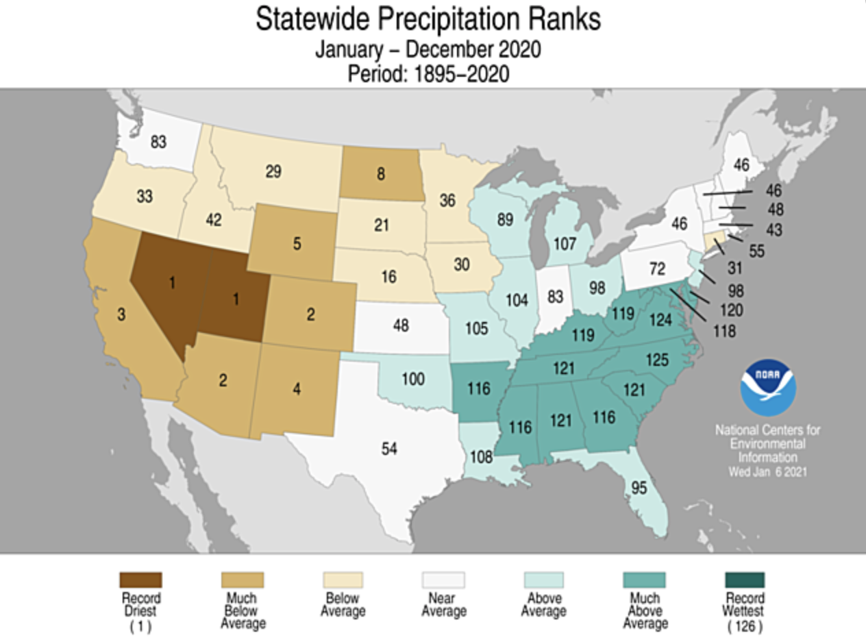
During December, temperatures were near normal and precipitation was generally below normal. January 1st snow-water equivalent was below normal for much of the region, especially in Utah. As a result, early season forecasts of spring runoff volume are below normal to much-below normal for the entire region except northern Wyoming. The seasonal runoff forecast for the Lake Powell inflow is only 53% of normal. Drought conditions remained unchanged, but extreme or exceptional drought covers over 60% of the region. The 2020 calendar year was one of hot drought; Utah recorded its driest and 7th hottest year and Colorado experienced its 2nd driest and 6th hottest year.
-
December precipitation was generally below-average for the region with the driest conditions occurring in Utah and northern Wyoming. Except for isolated locations that received average to above-average December precipitation, precipitation was less than 70% of average for most of Utah. Less than 50% of normal precipitation fell in northern Utah. Precipitation in Colorado during December was a mix of wet and dry conditions. Areas in eastern, central and northwestern Colorado saw above-average precipitation, while locations in western and northern Colorado received less than 70% of average precipitation. In Wyoming, above-average precipitation fell in central and southwestern Wyoming while precipitation in northern and western Wyoming was less than 50% of normal.
Image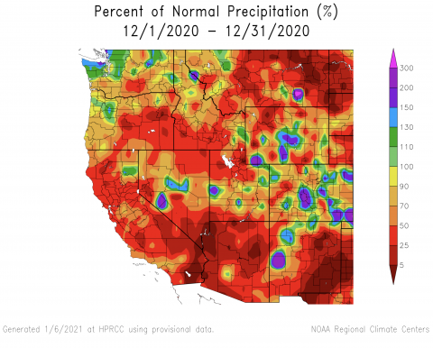
-
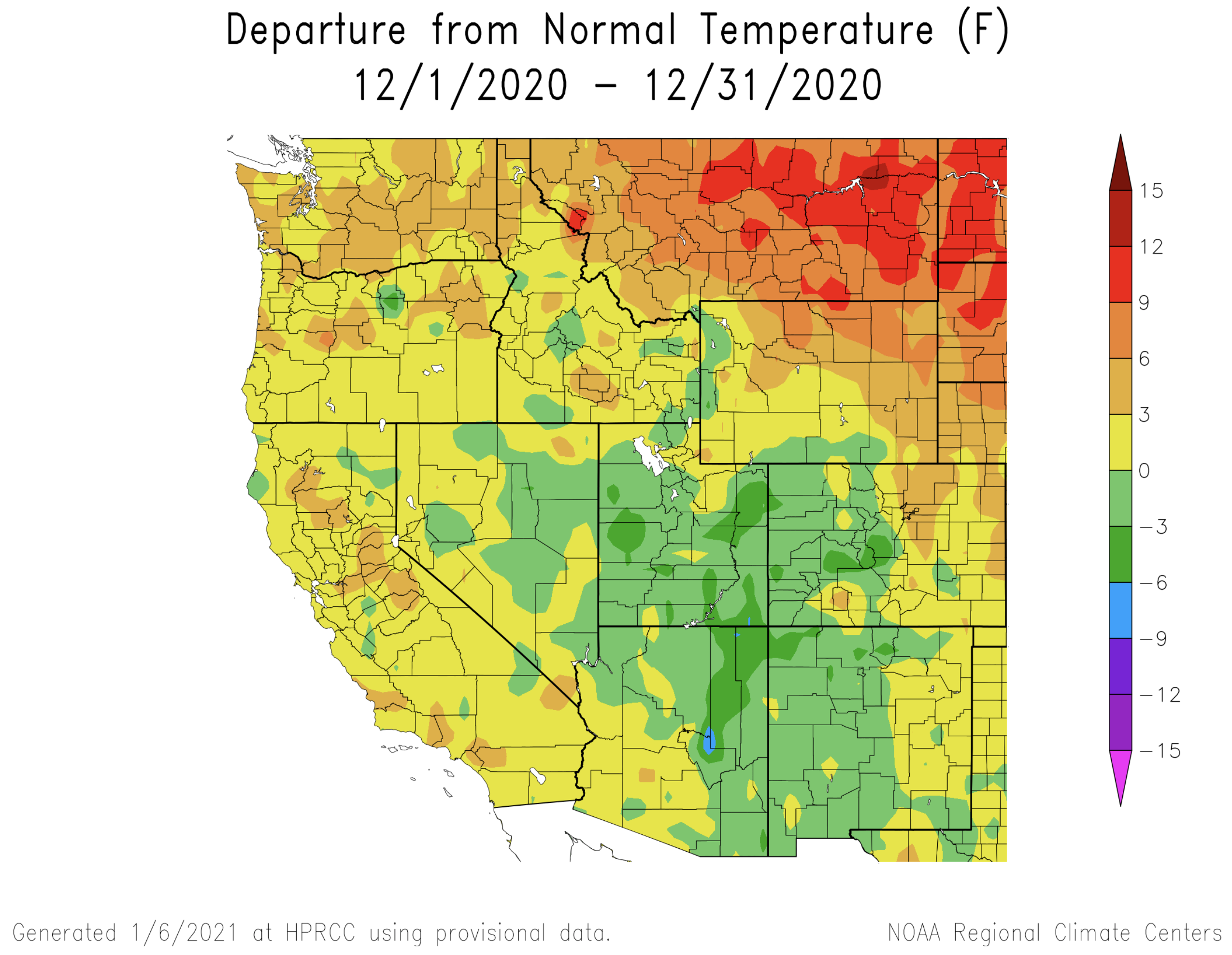
There was a northeast to southwest gradient in regional temperatures during December. Northeastern Wyoming experienced the warmest conditions with temperatures 3 – 9 degrees above normal. Eastern Colorado and southwestern Wyoming saw near normal temperatures while Utah recorded temperatures that were up to 6 degrees below normal.
Image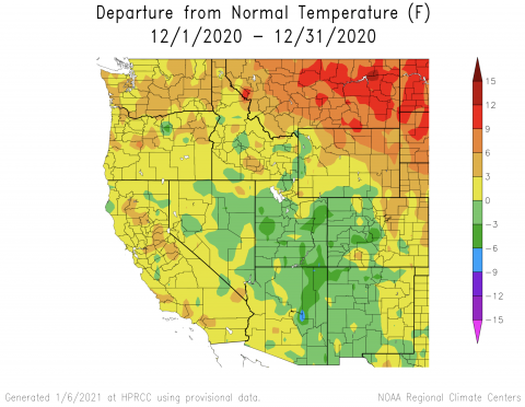
-
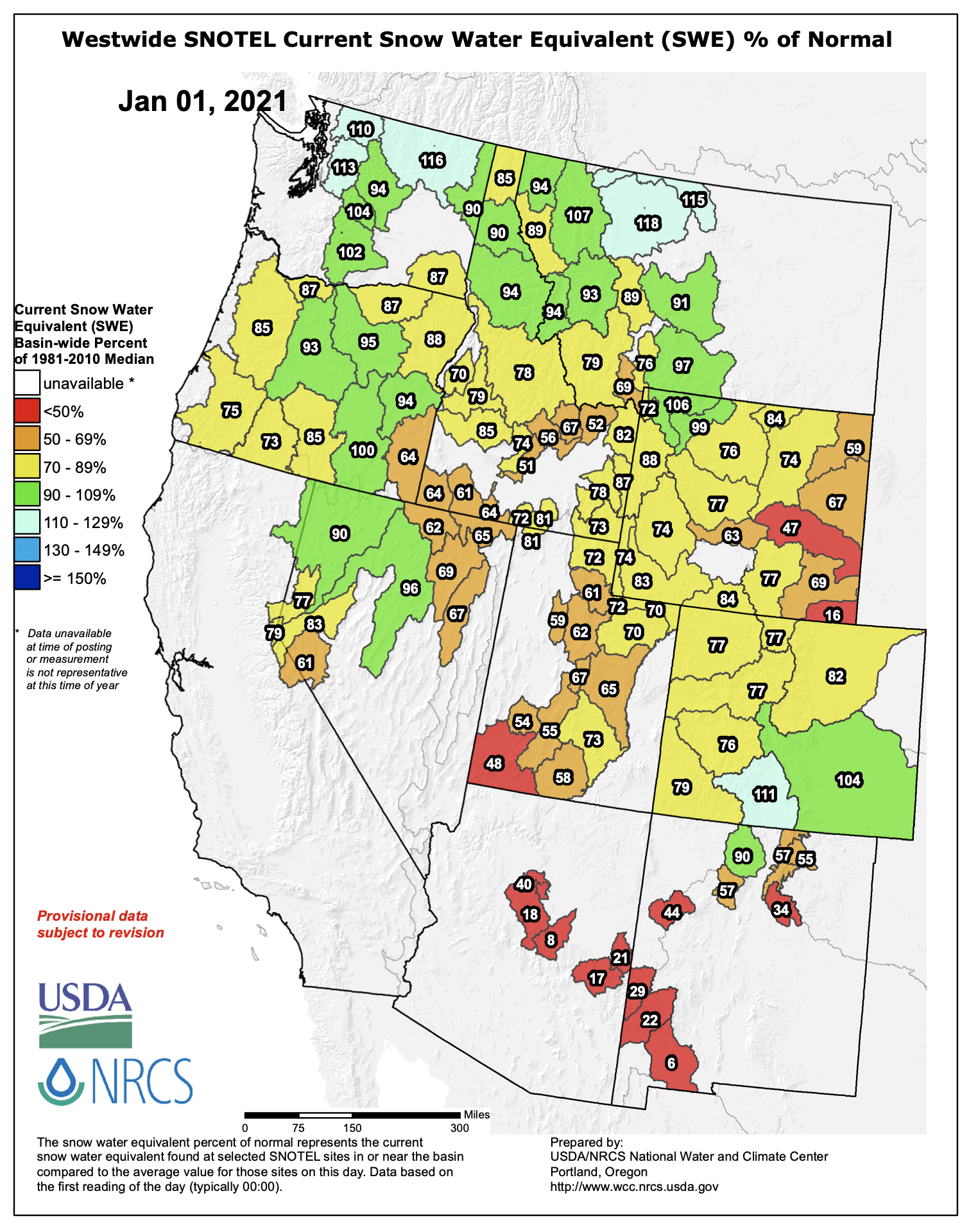
Snowpack in the Intermountain West was below normal on January 1st except for northwest Wyoming and the Rio Grande and Arkansas River basins in Colorado. January 1st snow-water equivalent (SWE) was lowest in Utah and eastern Wyoming. SWE in nearly all river basins in Utah was below 70% at the beginning of January. In most of Colorado and Wyoming, January 1st SWE was between 70 – 80% of normal.
Image
-
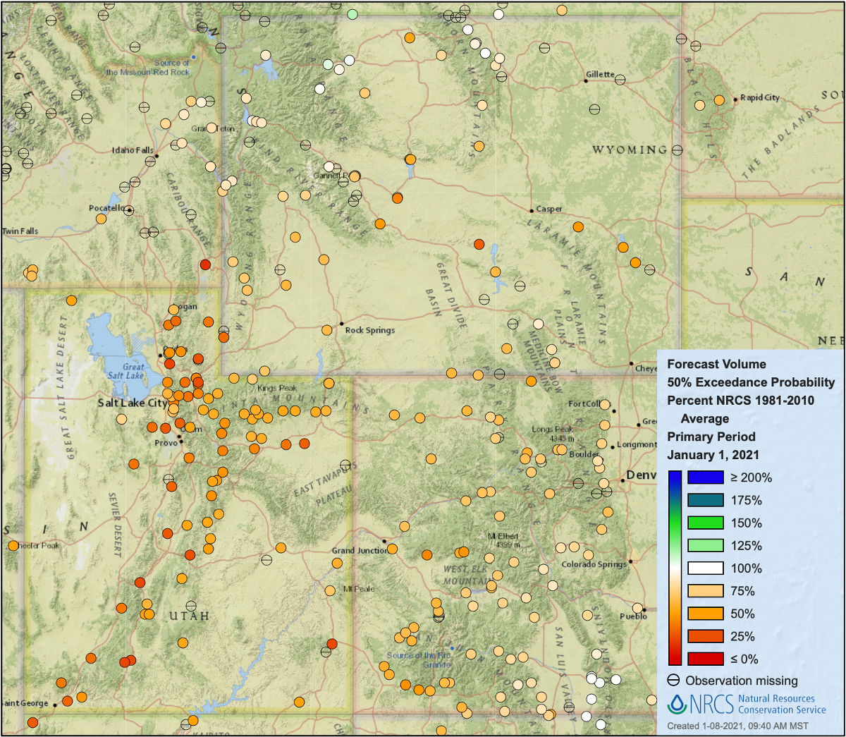
The NOAA CBRFC January 1st seasonal runoff forecasts for the Upper Colorado River basin were less than 70% of normal for nearly all portions of the basin. Seasonal runoff was forecasted at less than 50% of average for the Bear, Duchesne, Sevier, Virgin and Weber River basins. Small portions of the Upper Green and Colorado Rivers are forecasted to see 70-90% of average seasonal runoff volume. The January 1st inflow forecast for Lake Powell is 53% of normal or 3.8 million acre-feet. Outside of the Colorado River basin, NRCS forecasted seasonal runoff volumes are near average in southern Colorado and northern Wyoming.
Image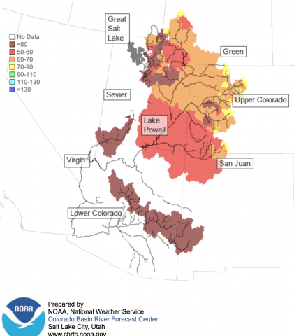 Image
Image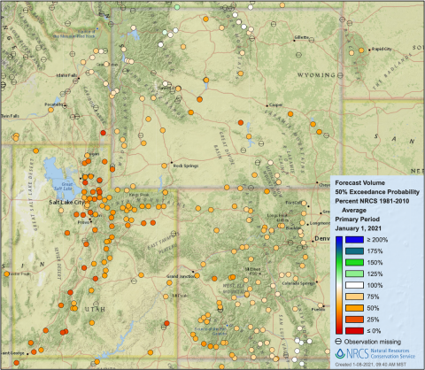
-
Drought conditions did not change in the Intermountain West. Drought covers the entire region except northwest Wyoming. Extreme (D3) or exceptional (D4) drought conditions cover 26% of Wyoming, 76% of Colorado and 90% of Utah. In Utah, D4 drought covers nearly 80% of the state. Drought is forecasted to persist for the entire region through March 2021.
Image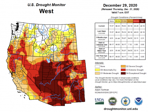
-
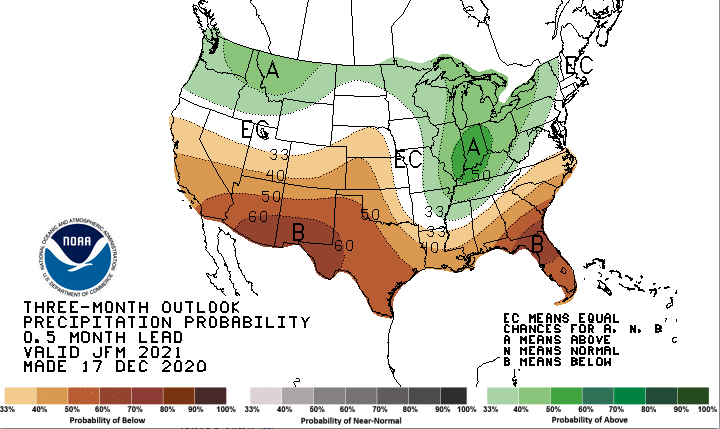
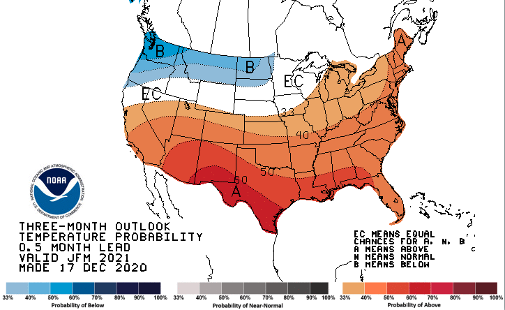
Moderate La Niña conditions continue in the Pacific Ocean with December sea surface temperatures around 2 degrees below normal. La Niña conditions are forecasted to continue through April. The NOAA one-month outlook for January suggests a slight increase in probability for above average precipitation in Utah ad southwest Wyoming and an increased probability of above average temperatures for Wyoming, most of Colorado and northern Utah. On the three-month timescale, there is an increased probability of below average precipitation in southern Utah and Colorado and an increased probability of above average precipitation in northwestern Wyoming. There is an increased probability of above average temperatures in January – March in Colorado and Utah.
Image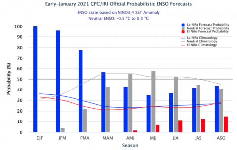 Image
Image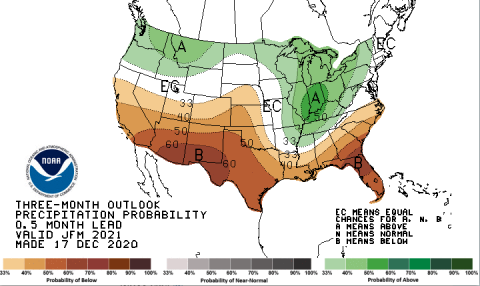 Image
Image
-
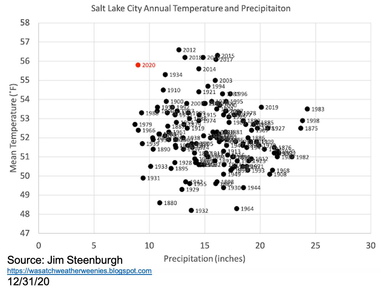
Significant December weather event. The lack of weather in December was significant as January 1st snow water equivalent (SWE) was below normal for much of the region, especially in Utah where SWE was below 70% in most of the state. Snowpack was lowest in southern Utah basins which is consistent with precipitation patterns caused by La Niña. A relatively dry December closed an extremely dry and hot calendar year 2020. In Utah, 2020 was the driest year on record and recorded the 7th warmest average temperatures. Colorado saw similar extremes; 2020 was the second driest and 6th hottest on record. Wyoming recorded the 5th driest and 15 warmest year on record. The coincidence of both very dry and hot conditions stands out in the historical record and represents the type of drought more likely in the future; hot drought. In Salt Lake City, the 2020 calendar year was an exceptional hot drought. It was the second driest and 6th warmest year and Salt Lake City and the first truly hot drought since the early 20th century (1910 and 1934). The hottest 7 years on record in Salt Lake City have all occurred in the last 9 years. While significant drought occurred in 2012, 2015 and 2018, precipitation was near average; high temperature drove drought conditions, not low precipitation. The current extreme drought conditions in Salt Lake City reflect the co-occurrence of very low precipitation and very hot temperatures.
Image Image
Image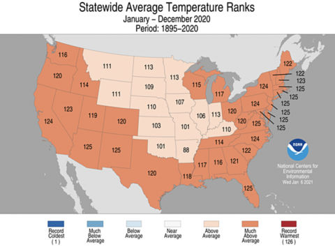 Image
Image