February 17, 2021 (UT, WY, CO)
-
During January, most of the region experience below average precipitation and near average temperatures. Snow-water equivalent (SWE) is below average in the region with most locations at 60-80% of average SWE. February 1st seasonal streamflow volume forecasts are much below normal for the entire region. The inflow forecast for Lake Powell is 46% of average. Over 60% of the region is experiencing extreme or exceptional drought.
-
January precipitation was generally below normal for the region. The majority of all three states saw less than 75% of normal precipitation, with pockets of less than 25% of normal precipitation in western Wyoming and southeast Utah. Isolated areas of all three states that received above normal precipitation included southwestern Utah, northwestern Colorado, southeastern Colorado and southern Wyoming. Regional precipitation was generally very low during the first three weeks of the month; several significant storms impacted the region in late January, especially in southern Utah and southwestern Colorado.
Image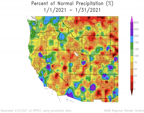
-
Temperatures were mostly near-average in January (+/- 3 degrees). In isolated areas along the Wasatch Front and in western Wyoming, temperatures were up to 6 degrees above normal. In the Uinta Basin of Utah, temperatures were up to 6 degrees below normal.
Image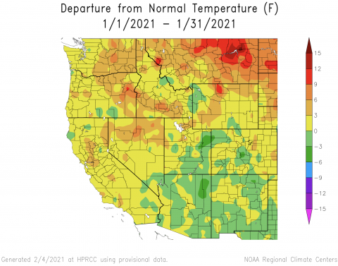
-
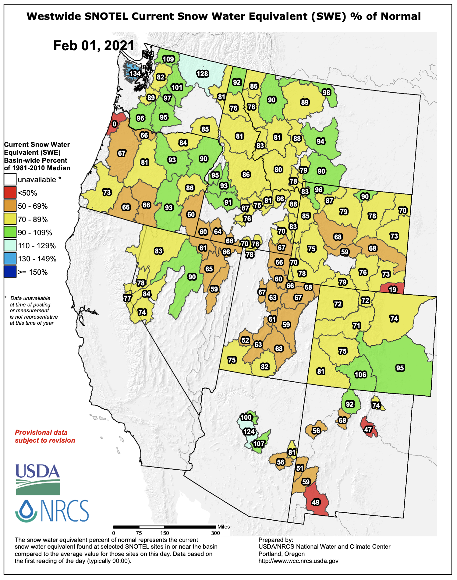
Snowpack remained below normal for nearly the entire region in January. As of February 1st, SWE was 60-80% of normal in most basins. In Utah, snowpack conditions improved slightly, but remain less than 70% of normal.
 SWE conditions in Colorado and Wyoming were slightly better than in Utah, but were less than 80% of normal for most river basins. Near-normal SWE conditions were present in only three regional river basins: the Rio Grande, Arkansas and Yellowstone.Image
 Image
Image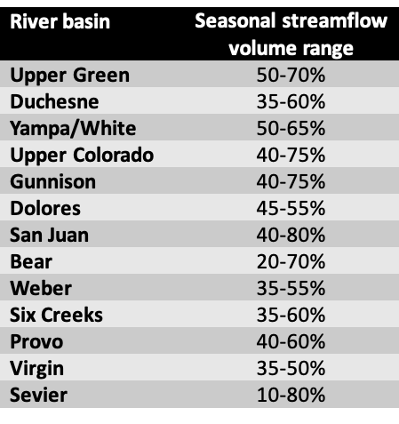
-
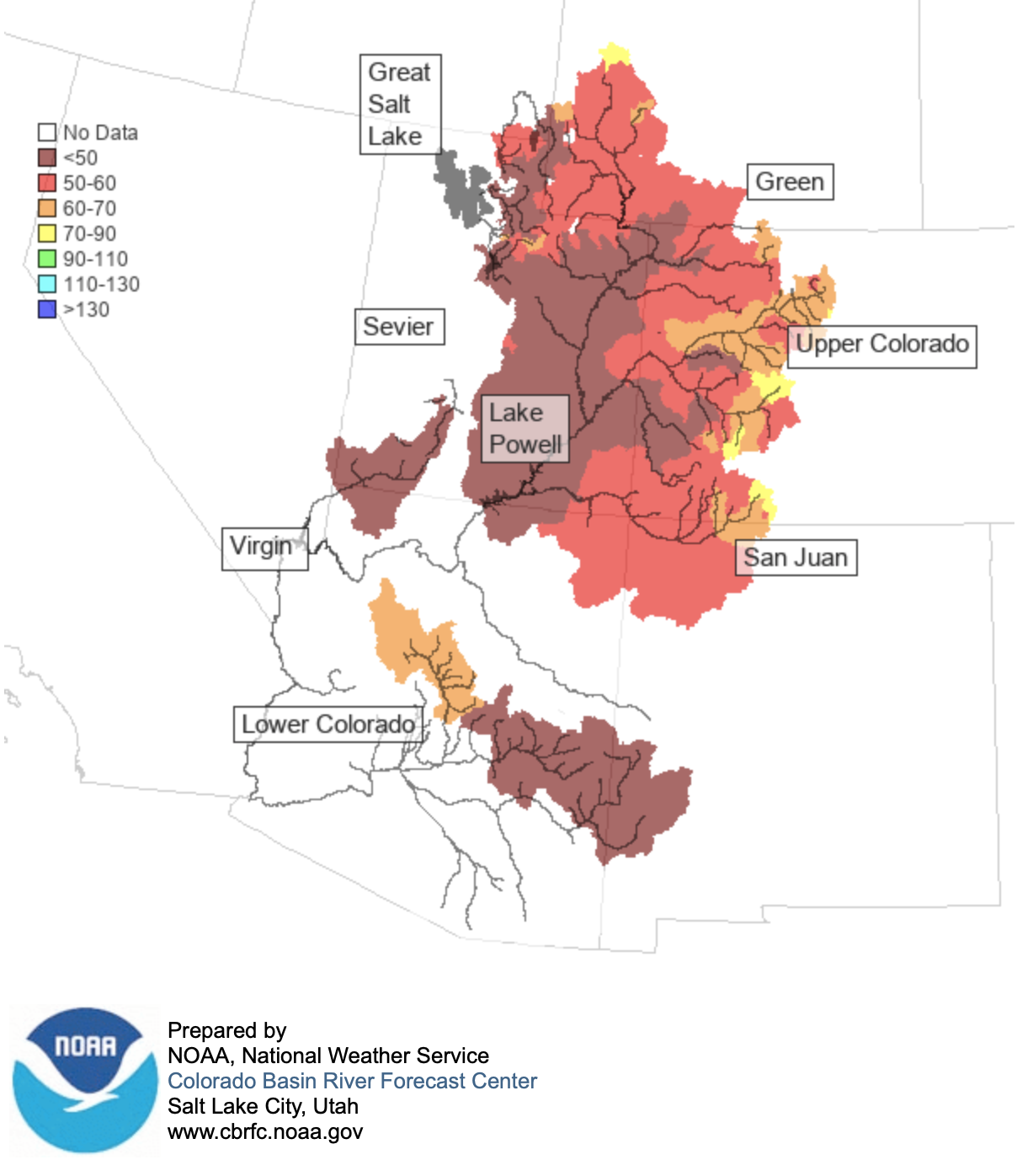
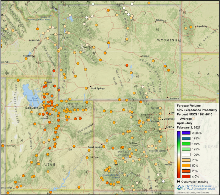
The NOAA CBRFC seasonal streamflow volume forecasts on February 1st were much-below normal for the entire Upper Colorado River and Great Basins. Only 8 sites in the entire basin were forecasted to have 70-80% of normal streamflow volumes (upper Colorado, upper Green and upper San Juan Rivers). Season streamflow volume forecasts were lower in Utah compared to Colorado and Wyoming. Northern Utah river basin seasonal streamflow forecasts ranged from 20-70% of normal. Atmospheric river events in southern Utah improved streamflow forecasts significantly, but remain much below normal on the Sevier and Virgin Rivers. At other locations in the basin, streamflow conditions were much below normal, but slightly better relative to average. Outside the Upper Colorado Basin, seasonal streamflow forecasts were below normal on the Arkansas (74%), Cache La Poudre (74%) South Platte (65%), North Platte (42%) and Snake Rivers. The only basins with near-normal seasonal streamflow forecasts was on the Shoshone (92%) and Yellowstone Rivers (86%).
Image Image
Image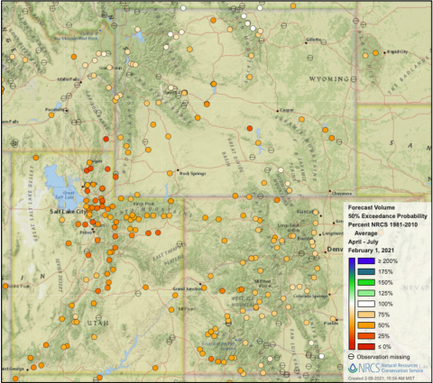
-
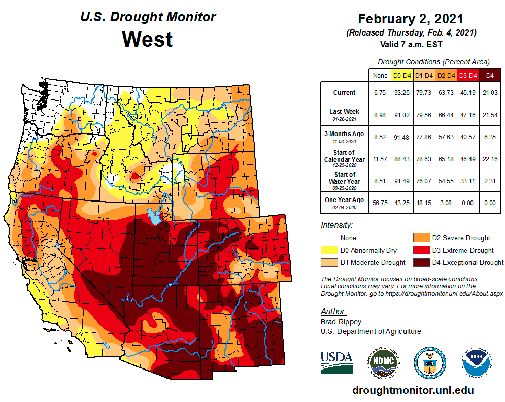
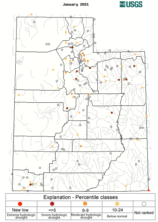
Very little improvement or degradation of drought conditions occurred during January and extreme (D3) or exceptional (D4) drought covers 63% of the region. Utah continues to see the worst regional drought conditions with 70% of the state experiencing D4 drought. Minor improvements to drought conditions occurred in southern and eastern Colorado; a one-category degradation of drought conditions occurred in northeastern Wyoming. Extremely low January streamflow at sites in Utah and Colorado validate the extreme and exceptional drought conditions. The lowest January streamflow on record was observed on the San Juan River in Bluff, UT. Rivers where January streamflow was below the 5th percentile of all January observations included: the Duchesne, Price, Provo, Sevier, Virgin and Weber Rivers in Utah and the Animas, Blue, Mancos, North Cache La Poudre and Roaring Fork Rivers in Colorado.
Image Image
Image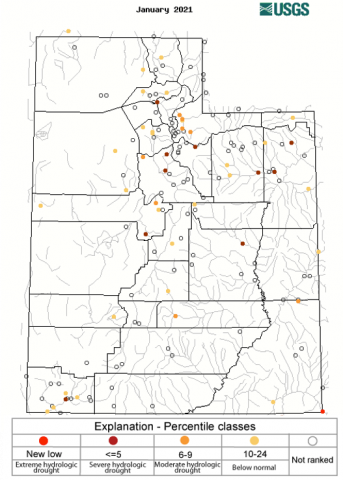
-
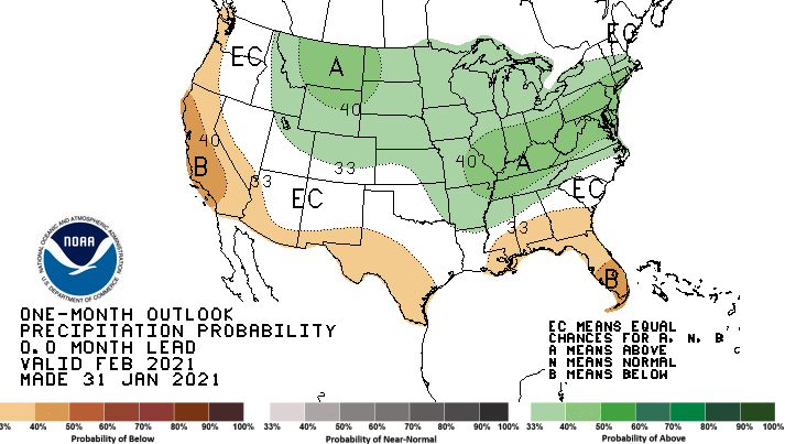
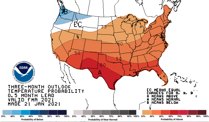
La Niña conditions continue with eastern Pacific Ocean temperatures ranging from 0.5° - 1.5°F below average. By spring, there is a 70% probability of neutral ENSO conditions. NOAA one-month outlooks suggest an increased chance of above average February precipitation for Wyoming, northeastern Utah and northern Colorado with northern Wyoming having the greatest chance of above normal precipitation.
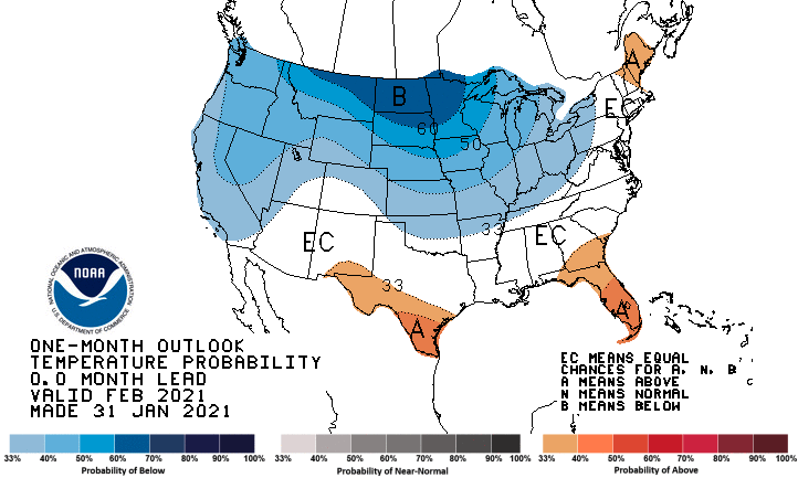
 There is an increased probability for below-normal temperatures for the entire region, except southeastern Utah and southern Colorado; northern Wyoming has the greatest chance of below normal temperature.
  A more customary La Niña weather pattern is expected to return for February – April. There is an increased probability for below average precipitation in southern Utah and Colorado
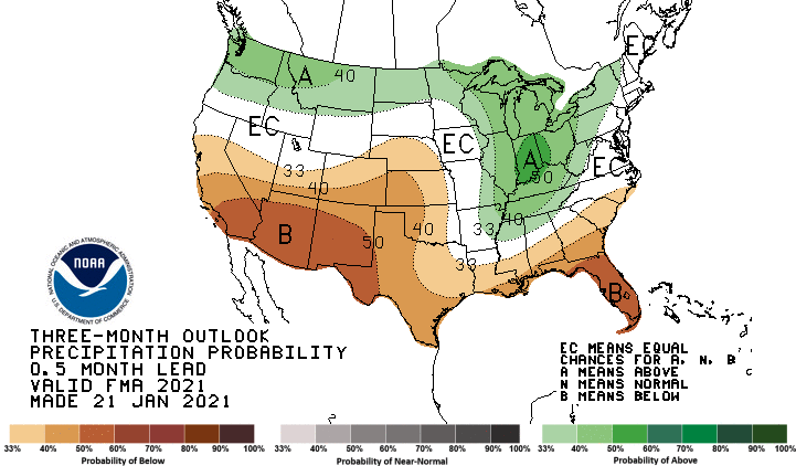
  and there is a higher chance of above average temperatures for the entire region except northern Wyoming.Image
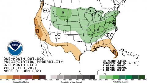 Image
Image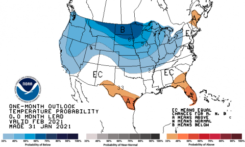 Image
Image Image
Image
-
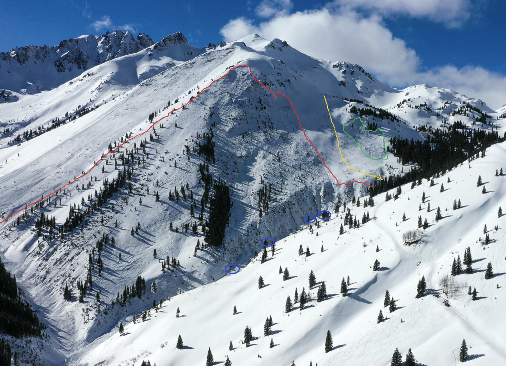
Significant January weather event. In the 8-day period from January 30th – February 6th, ten people died in avalanches in Colorado and Utah. Two incidents involved multiple fatalities. An avalanche on February 1st in the San Juan Mountains claimed the lives of 3 backcountry skiers and on February 6th, an avalanche in the Wasatch Mountains near Salt Lake City killed 4 skiers. Fifteen people died in avalanche across the United States over this 8-day period, the most deadly sequence of avalanches since a 1910 accident on Stevens Pass, Washington that killed 96 people. Below average snowfall snow conditions during early winter and a 3-week snow drought in January caused unstable layers in the snowpack, then strong storms during the end of January were the ingredients for very dangerous avalanche conditions. Higher backcountry skier usage this winter due to the coronavirus pandemic likely played a role in the high number of avalanche fatalities this season.
Image