December 16, 2020 (UT, WY, CO)
-
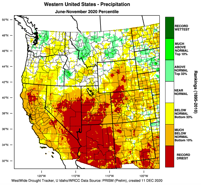
November precipitation was below normal for much of the region, leading to below average snowpack in most areas. Utah saw the least precipitation and snowpack is generally less than 70% of average. As a result, drought conditions significantly worsened in Utah; exceptional (D4) drought expanded to cover three-quarters of the state. Stream gages on the Animas, Bear, San Miguel and San Juan Rivers recorded record low average streamflow conditions in November. La Niña conditions are expected to continue throughout the winter and may lead to below average precipitation in southern Colorado and Utah.
-
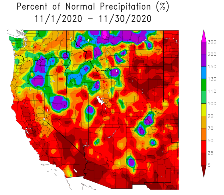
November precipitation was below normal for much of the region. The majority of Colorado, Utah and Wyoming received less than 50% of normal November precipitation. A large swath of central Wyoming received less than 5% of normal precipitation. A portion of northeastern Utah observed near normal precipitation. Above average November precipitation fell in northwest Wyoming, western Utah and central Colorado.
Image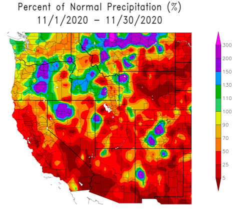
-
Regional temperatures were a mix of above average and near average during November; there was an east-to-west temperature gradient with cooler temperatures in the western portion of the region and warmer temperatures to the east. In most of Utah and western Wyoming, temperatures were near normal except for the Wasatch Front which was 2-4°F above average. Temperatures across Colorado and much of Wyoming were 2-6°F above average.
Image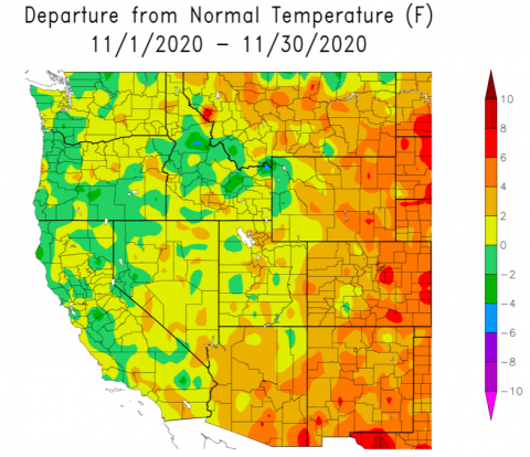
-
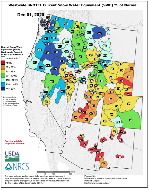
Snowpack in the Intermountain West was generally below normal as of December 1st. Snow water equivalent (SWE) in most Utah river basins was less than 70% of average; SWE in northern Utah was closer to average. In Colorado river basins, SWE was generally below normal, but closer to average than in Utah. Snow pack was near normal in the Arkansas River basin and above normal in the Rio Grande basin. Snowpack was near to above normal in western Wyoming but less than 80% of average for the remainder of the state.
Image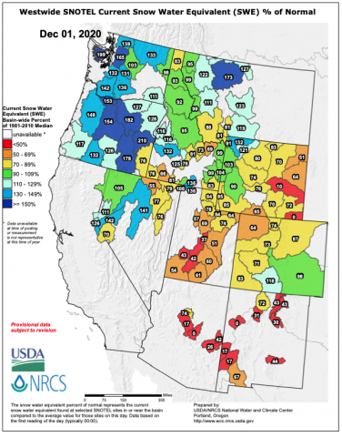
-
Monthly streamflow in November was much below normal at many locations. Record low November streamflow was observed at gages on the Animas, Bear, San Juan and San Miguel Rivers. Monthly streamflow was in the 5% of lowest Novembers for the Colorado (Lees Ferry and Cameo), Dolores, Eagle, North Fork Gunnison, Provo, Roaring Fork and Sevier Rivers. Low streamflow during late fall is an indicator of drought and suggests that the following spring runoff will be inefficient (for example, average snowpack conditions could yield 85% of average runoff).
-
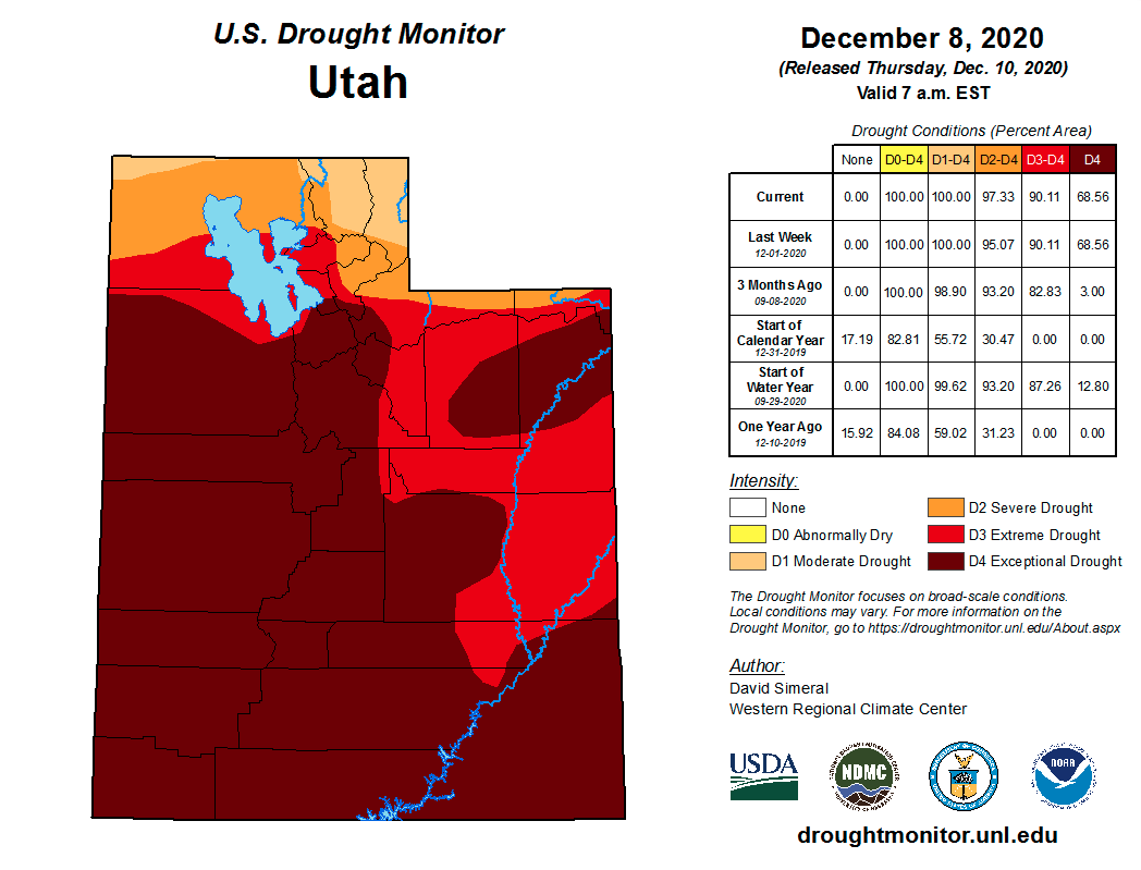
During November, drought conditions worsened in Utah and remained mostly unchanged in Colorado and Wyoming. In Utah, exceptional (D4) drought conditions significantly expanded to cover 69% of the state’s area. Extreme (D3) or exceptional (D4) drought now covers 90% of Utah; moderate (D1) and severe (D2) drought cover a small portion of northern Utah. Drought conditions in Colorado remained largely the same except for southwestern Colorado where D4 drought expanded. Extreme or exceptional drought covers 76% of Colorado. Drought conditions in Wyoming are slightly better than Utah and Colorado, but 87% of the state is in at least D1 drought and 26% of the state is in D3 drought.
Image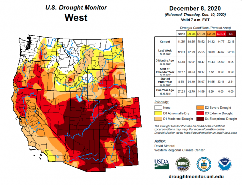 Image
Image
-
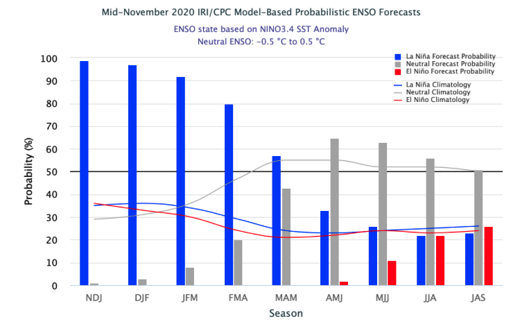
A La Niña advisory is still in effect and there is a 95% chance of La Niña conditions continuing throughout the winter, likely dissipating in spring. Eastern Pacific Ocean temperatures are nearly 2°F below normal which indicates La Niña conditions. Weather patterns in the western United States during November were consistent with a La Niña pattern; there was above average precipitation in the Northwest and below average precipitation in the Southwest. The NOAA outlook for December – February predicts an increased probability of above average precipitation in northern Wyoming and an increased probability for below average precipitation in southern Colorado and Utah. There is also an increased probability of above average temperatures in Colorado, Utah and southwestern Wyoming for December, January and February.
Image Image
Image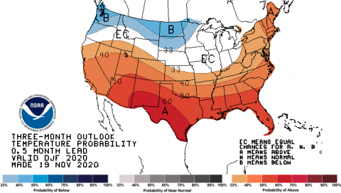
-
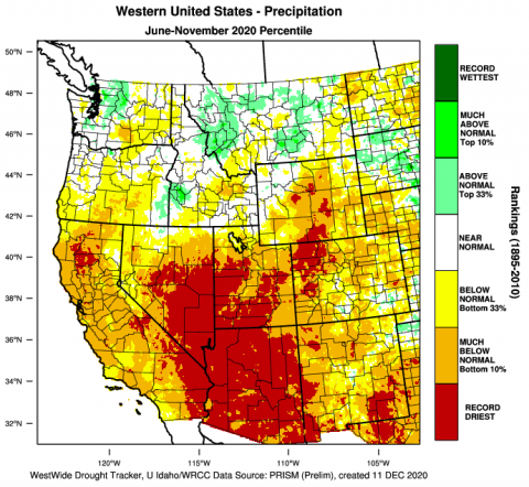
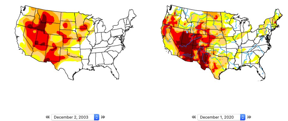
Significant November weather event. Despite several snowstorms, drought conditions expanded significantly during November in Utah. Extreme and exceptional drought covers over 90% of the state and drought conditions in Utah during December 2020 were the worst December drought conditions in the last 20 years. In December 2003, drought conditions were similarly dry when extreme or exceptional drought covered the entire state. Nearly half of Utah experience the driest July – November period on record and July – November precipitation was in the 10% of driest years since 1895 in all but extreme northern Utah. A record high temperature of 70°F was set in Salt Lake City on November 17th.
Image Image
Image