December 10, 2014
Highlights
- November brought mixed results for precipitation for the region, with most Colorado and Wyoming mountain areas wetter than average, and nearly all of Utah much drier than average.
- The snowpack is still lagging behind normal conditions in most of the region's basins, with southwestern Colorado, southern and eastern Utah, and southeastern Wyoming under 70% of median.
- Most indicators continue to move in the direction of El Niño, with the forecasts indicating that the probability of onset is around 60% through the winter months.
Click on the thumbnail images in the text below to bring up the full-sized graphic
November Precipitation and Temperatures, and Current Drought
For precipitation, November brought a wide range of outcomes for the region . Nearly all of Utah experienced much-drier-than-average conditions, especially in the southern and western parts of the state. Central Wyoming was dry, while northwestern Wyoming was much wetter than average, as were portions of southern Wyoming. Many of Colorado’s mountain areas ended up above average, but eastern Colorado was very dry.
November’s monthly mean temperatures were strongly influenced by two Arctic cold waves, with mostly warmer-than-average temperatures south and west of the intrusions in Utah and Colorado, and colder-than-average temperatures elsewhere . Northern Wyoming saw temperatures 3–9°F colder than the monthly normal. By some measures, the cold wave from the 10th-14th was the most severe on record for November for the Colorado Front Range, but mild temperatures for most of the rest of the month meant that Denver ended up only 2°F below November’s monthly normal.
The latest US Drought Monitor , based on conditions as of December 2, shows no change in drought conditions compared to early November, and no change since mid-October. The proportion of the region in D2 or worse drought remains: Utah at 13%; Colorado at 12%, and Wyoming at zero.
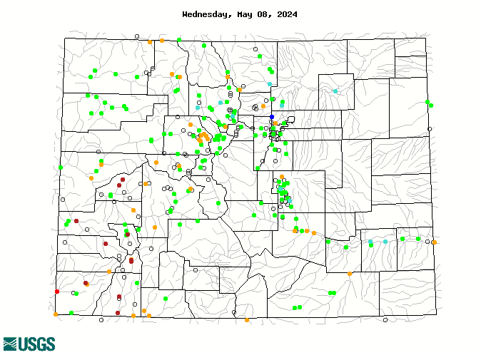
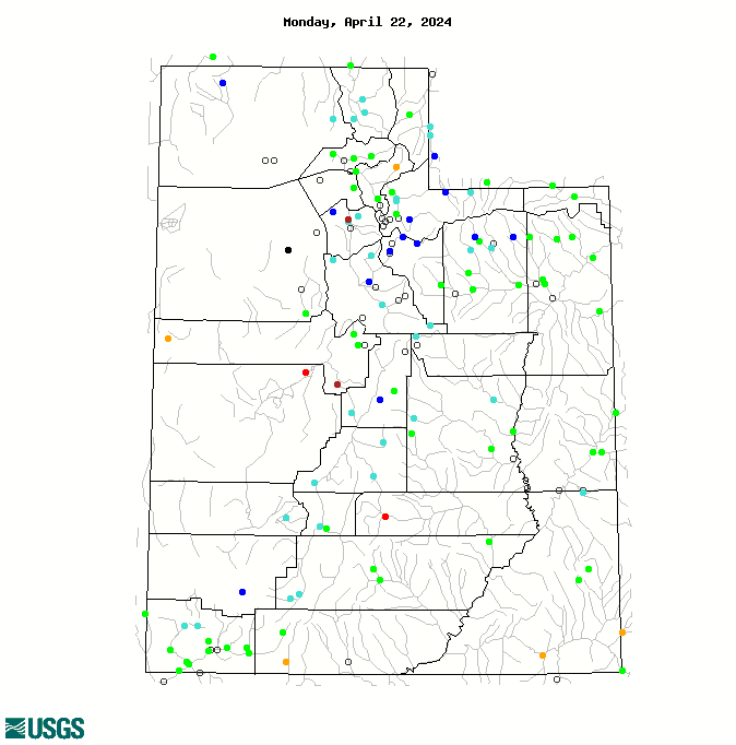
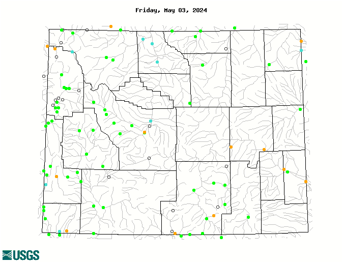
Current Streamflows
As of December 9, the maps of current streamflows for Colorado , Utah , and Wyoming show that flows are normal to above normal in Colorado and Wyoming, and mainly normal or below normal in Utah. Ice is affecting an increasing number of gages, especially in Wyoming, as is typical for this time of year. On December 9, the Colorado River near Cameo, CO was in the 80th percentile, 120% of median flow; the Green River near Greendale, UT was in the 49th percentile, 99% of median flow; and the San Juan River near Bluff, UT, was in the 55th percentile, 105% of median flow.
Current Snowpack
The Current Basin Snowpack map from NRCS as of December 10 shows below-median SWE across most of the region’s basins. The several basins with above-median SWE are in western Wyoming, northeastern Wyoming, and northern Utah and south-central Utah. The driest basins, with below 70% of median SWE, are in southwestern Colorado, southern and eastern Utah, and southeastern Wyoming.
Seasonal Climate and Drought Forecasts, including ENSO
The monthly Climate Outlook for December released on November 30 by NOAA CPC shows a slight wet tilt for precipitation for the month of December for far southern Colorado and the southern two-thirds of Utah, and a slight dry tilt for far northern Wyoming. The seasonal outlooks released November 20 show a slight wet tilt in December–February period for far southern Colorado and Utah. For the January–March period , the area of wet tilt covers most of Colorado and the southern half of Utah.
The latest CPC Seasonal Drought Outlook released November 20 projects that the areas of drought conditions (D1 or worse) in southwestern and south-central Colorado and southern Utah will improve, or be removed, by the end of February. However, the areas of drought in central and northern Utah, and southeastern Colorado, are projected to persist or intensify during that period. No additional areas of drought development in the region are expected.
Compared to the previous briefing, the updated Experimental PSD Seasonal Precipitation Forecast Guidance ('SWcast') for the January–March period shows a more 'bullish' tilt towards above-average precipitation over most of Colorado and southern Utah. There is a slight dry tilt forecasted for northern Utah. (The statistical SWcast model targets different indicators of climate system behavior than the dynamical model that drives the CPC outlooks.)
In the tropical Pacific region, most indicators continue to lurch towards El Niño conditions. The Multivariate ENSO Index (MEI) for the October–November period popped back up into weak El Niño territory. The weekly benchmark Niño 3.4 sea-surface temperature (SST) index has risen further, to 1.0°C. According to the December 4th ENSO discussion from NOAA CPC, “Although the SST anomalies alone might imply weak El Niño conditions, the patterns of wind and rainfall anomalies generally do not clearly indicate a coupling of the atmosphere to the ocean.”
The latest ENSO forecasts still indicate a good chance that an El Niño event will officially emerge in the next several months. The early-December ENSO Probabilistic Forecast from NOAA CPC and IRI puts the odds of El Niño onset by February at over 60%, but dropping off to 50% by June 2015. If an El Niño does develop, it is increasingly likely to be a weak event. The forecasts indicate very little chance of a La Niña event developing before spring 2015.