April 10, 2020 (UT, WY, CO)
- Just past the typical time of peak snowpack in the Intermountain West, nearly all locations in Colorado, Utah and Wyoming have near-average to slightly above-average snowpack conditions. Seasonal runoff forecasts for the region are typically near to below average; below-average runoff conditions in southwestern Colorado and portions of Utah are in part due to low soil moisture conditions entering the current water year. Strong storms during the first half of March in the southern portion of the region led to improvements in snow conditions and runoff forecasts for the Virgin and San Juan River basins.
- Precipitation was varied throughout the region during March. On a statewide basis, Colorado precipitation was near average, Utah precipitation was above average and Wyoming precipitation was below average. The driest conditions were experienced in southeastern Colorado, across Wyoming, and in central Utah. Wetter-than-average conditions were seen in western Colorado, southern and eastern Utah and western Wyoming, with widespread areas that received 125 – 150% of normal precipitation and isolated areas that received greater than 200% of normal precipitation.
- During March, near-average to slightly above-average temperatures were found in Utah and Wyoming. In Colorado, March temperatures were well above average; temperatures were 2 to 4 degrees above normal for much of the state, with southeastern Colorado seeing temperatures that were up to 6 degrees above normal.
- Snowpack in the Intermountain West is generally near normal to above normal as of April 10th. Over the entire region, only two areas have less than 90% of median snowpack: northeastern Wyoming and southern Colorado. Snowpack conditions are 90 to 110% of median in most basins in the Intermountain West. In much of Wyoming and a in few areas of Utah and Colorado, snowpack conditions are above normal (110% to 130% of median). Over the last month, snowpack in the San Juan River basin in southwest Colorado improved from 80% of median to 92% of median. Regionally, the Virgin River basin of southwest Utah has the deepest snowpack relative to normal.
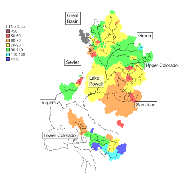
- The NOAA CBRFC April 1st seasonal runoff forecasts for the Upper Colorado River Basin and the Great Basin are generally near to below average . Near to slightly above average (90 to 110%) seasonal runoff is forecasted for the Bear River, mainstem of the Colorado River, Duchesne River, upper Green River, San Rafael River, Six Creeks, Virgin River and Yampa/White River basins. Slightly below to below normal (70 to 90%) seasonal runoff is forecasted for the Dolores, lower Green, Gunnison, Provo, San Juan, Sevier and Weber River basins. The April 1st inflow forecast for Lake Powell is 78% of average (5.6 maf), a slight decrease from the March 1st forecast (76%). The NRCS April 1st seasonal runoff forecasts call for slightly higher runoff volumes than the NOAA CBRFC forecasts in much of Utah and northwestern Colorado. Seasonal runoff volume forecasts in Wyoming are generally near to above average. East of the Continental Divide in Colorado, April 1st NRCS seasonal runoff volume forecasts are mostly above average (Cache La Poudre, South Platte, North Platte and Arkansas River basins).
- Localized changes in drought conditions occurred throughout the Intermountain West during March. Wyoming remains nearly free of drought, but a small area of D0 drought emerged along the eastern slope of the Wind River Mountains. DO and D1 conditions continue to cover much of Colorado and Utah. In Colorado, D1 covers nearly 47% of state, with another 18% in D0 and 3% in D2. D1 expanded in eastern Colorado, while a one- category improvement occurred in northwestern Colorado. Some improvements in drought occurred in Utah during March. D1 drought coverage decreased in March, to 43% of the state’s area, with a small sliver (1%) still in D2. A one-category improvement to drought conditions occurred in both southwestern and northeastern Utah. D0 conditions expanded northward in the West Desert of Utah.
- Tropical Pacific Ocean temperatures were slightly warmer than average during February and March but have been trending towards average. ENSO-neutral conditions are currently observed and are likely to persist through late summer. By fall, ENSO forecasts call for nearly equal probabilities of neutral, El Niño or La Niña conditions. In the Intermountain West, NOAA one-month precipitation and temperature outlooks predict a 30-50% chance of above average precipitation for much of Utah and a 30-50% chance of below average temperatures for most of Utah and Wyoming. Three-month NOAA outlooks forecast a 30-50% chance of below average precipitation for all of Utah and western Colorado and above average temperatures for the entire region.
- Significant regional weather event for March. On March 12-15, a significant storm impacted southwestern Utah, dumping up to 2” of rain to valley locations and 2-4” of water to the mountain locations. A CoCoRaHS observer in St. George reported 2.07” of rain on March 13-14, a 1-in-50-year event according to NOAA ATLAS-14 precipitation frequency estimates. Snotel sites in the Virgin River basin to the north and east of St. George recorded 3-4” snow water equivalent from March 12-15. This storm contributed to a significant March increase in the seasonal runoff forecast for the Virgin River basin, increasing from about 70% to 110% of average runoff.