April 10, 2015
Highlights
- March was disastrous for the region’s snowpack and the expected spring–summer runoff. Snow conditions and forecasted runoff are now similar to 1977, 2002, and 2012 in many parts of the region, particularly in Utah.
- March brought a double-whammy of well-below-average precipitation and near-record warmth over most of the region, including nearly all mountain areas.
- Since early March, the snowpack has significantly declined relative to normal conditions across the region. Most basins are now reporting less than 70% of median SWE, and the majority of individual SNOTEL sites are below the 5th percentile for SWE.
- The April 1 spring-summer runoff forecasts are lower or much lower than the March 1 forecasts across the region. Most forecast points are now expected to see much-below-average (50–69%), far-below-average (25–49%) or extremely low (<25%) runoff, with Utah seeing generally lower forecasts than Colorado and Wyoming.
- El Niño conditions have strengthened slightly in the last month and are expected to continue at least through the summer. The wet tilt in seasonal precipitation forecasts for parts of our region is predicated on a typical El Niño influence over the next several months.
Click on the thumbnail images in the text below to bring up the full-sized graphic
March Precipitation and Temperatures, and Current Drought
March was drier than average over nearly the entire region. Storms were infrequent and when they did occur, they moved through the region quickly, and were warmer than normal. Most mountain areas received 25–75% of average precipitation, with the Wasatch Range seeing yet another very dry month with 25–50% of average. The few wet spots in the region included south-central Wyoming, and southwestern Utah.
For the month, Utah was in the 26th percentile for statewide precipitation, Colorado was in the 17th percentile for statewide precipitation, and Wyoming was the driest of the three states, in the 4th percentile.
More extraordinary than the low precipitation were the abnormally warm temperatures in March, with most of the region seeing temperatures 4–8°F warmer than the monthly normals. For comparison, typically April is 7–9°F warmer than March across the region, so March 2015 was more like a normal April than a normal March. Once again, the warmest areas were in northern Utah and southwestern Wyoming, along with parts of southern and northeastern Wyoming. Salt Lake City followed the warmest winter season (December–February) on record with its record-warmest March.
The statewide average temperatures for March were close to record warmth in all three states: Utah, 98th percentile; Wyoming, 97th percentile; and Colorado, 96th percentile. Overall, the January–March period was the warmest on record for both Utah and Wyoming, and in the 97th percentile for Colorado. Since the beginning of the 2015 water year, only November has been colder than average across the region.
The latest US Drought Monitor, based on conditions as of April 7, shows that since early March, conditions over most of western Colorado and adjacent eastern and northern Utah have continued to degrade, from moderate drought (D1) to severe drought (D2). An area of severe drought (D2) in northwestern Utah has greatly expanded, and the area in extreme drought (D3) has likewise increased. Far western Wyoming went from drought-free to abnormally dry (D0), as did an area in north-central Colorado. The proportion of Utah in D2 or worse drought has increased dramatically from 13% last month to 53%; likewise in Colorado, which went from 12% to 40%. Wyoming has seen a slight bump from zero to 1%.
Current Streamflows
As of April 6, the maps of current streamflows for Colorado, Utah, and Wyoming show that flows are generally above normal or much above normal in Colorado and Wyoming, with several gages in the Colorado River headwaters at record high flow for the date. In Utah nearly all of the flows are in the normal and below-normal classes. Where above-normal flows are occurring in the region, it is an indication of the widespread premature snowmelt and runoff. On April 6, the Colorado River below Glenwood Springs, CO was in the 85th percentile, 141% of median flow; the Green River near Greendale, UT was in the 59th percentile, 121% of median flow; and the San Juan River near Bluff, UT, was in the 23rd percentile, 56% of median flow.
Current Snowpack
Between the well-below-average precipitation and extremely warm temperatures, the region’s snowpack has taken a real beating since early March. The Current Basin Snowpack map from NRCS as of April 8 shows that all of the region’s basins are below 90% of median SWE, and over two-thirds of them are below 70% of median SWE. At the majority of SNOTEL sites across the region, current SWE is below the 5th percentile relative to the last 20–40 years, and 28 sites are at record-low levels, mostly in Utah. Many sites at lower elevations in Utah have melted out completely, and most other sites across the region have seen significant melt in the past few weeks, up to a month ahead of the usual initiation of melt.
Field observers with the Colorado Dust-on-Snow program in mid-March found nearly isothermal temperature profiles (i.e., 32°F from top to bottom) within the snowpack across Colorado's mountains—a precondition for spring melt-—much earlier than usual. They also noted larger-than-usual differences between snow conditions on south- and north-facing slopes, with very thin cover or bare ground on many south-facing slopes, even at high elevations. This observation raised the concern that the SNOTEL network may be overestimating actual SWE on the landscape this spring. About the only good news for the snowpack was that dust-on-snow deposition in Colorado has thus far been much lighter than in recent seasons, with only two weak events in the San Juans.
Spring-Summer Streamflow Forecasts
In the April 1 spring-summer streamflow forecasts, released by NOAA CBRFC and the NRCS in early April, the expected runoff has dropped substantially compared to the March 1 forecasts across the region. Regionally, the outlook is for an extremely poor runoff season, along the lines of 1977, 2002, and 2012 in most basins.
The NRCS Westwide Streamflow Forecast Map shows that nearly all forecast points in Utah are now expected to have far-below-average (25–49%) or extremely low (<25%) spring and summer runoff. Wyoming and Colorado forecast points are split between below-average (70–89%), much-below-average (50–69%), and far-below-average (25–49%) runoff, with the lower flows expected in southwestern Colorado and central Wyoming than elsewhere. Only a few scattered forecast points in Colorado and Wyoming are now expected to have near-average (90–109%) spring and summer runoff. The Lake Powell inflow forecast has declined dramatically since March 1, to around 50% of average; see the Note below.
Whatever April–July runoff does occur, we also can expect that the hydrograph and its peak will likely be shifted earlier by 1-4 weeks or more compared to average conditions, depending on how the weather plays out over the next three months.
IMPORTANT NOTE: While NRCS and NOAA continue to collaborate on streamflow forecasts, the forecast values are no longer being strictly coordinated between NRCS and some of the RFCs, including the CBRFC. For example, the NRCS April 1 forecast for Lake Powell April–July inflows is 3200 KAF, 45% of average. The NOAA CBRFC April 1 forecast for the same point is 3750 KAF, 52% of average.
Seasonal Climate and Drought Forecasts, including ENSO
The monthly Climate Outlook for April released on March 31 by NOAA CPC shows a dry tilt for precipitation in the northern Great Plains, extending into northeastern Colorado and eastern Wyoming. The seasonal outlooks released March 19 show a slight wet tilt in both the April–June and May–July periods for most of the region, with a stronger wet tilt for southwestern Colorado. The overall pattern of wet tilt in the southwestern and southeastern US is associated with El Niño conditions.
The latest CPC Seasonal Drought Outlook released on March 19 projects that areas of drought conditions (D1 or worse) in southeastern Colorado will improve or be removed by the end of June. Drought areas in Utah and the rest of western Colorado are expected to persist or intensify. No additional areas of drought development in the region are expected.
The Experimental PSD Seasonal Precipitation Forecast Guidance ('SWcast') for the April–June period issued on March 16 shows a tilt towards above-average precipitation over most of eastern and southwestern Colorado, and northwestern Utah. The wet tilt is strongest on the eastern plains of Colorado. There is a slight dry tilt forecasted for the far northeastern corner of Colorado. The pattern is similar to that seen in a composite of past spring seasons with weak El Niño conditions. (Note: "Skill-masked" means that the forecast only shows the tilts for those areas where there has been demonstrated forecast skill for this season in the past.)
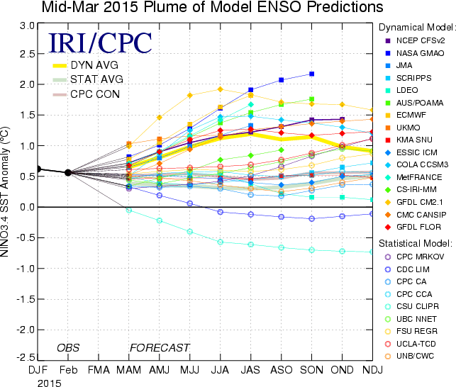
In the tropical Pacific region, weak El Niño conditions continue, with some recent warming of sea-surface temperatures in the diagnostic regions of the tropical Pacific. The Multivariate ENSO Index (MEI) rose slightly in the February–March period but remains in weak El Niño territory. A slight majority (50-60%) of the individual ENSO model forecasts compiled by IRI in the mid-March ENSO Prediction Plume call for El Niño conditions to continue through summer 2015. The dynamical models as a group call for strengthening El Niño conditions, while the statistical models generally favor weakening.