Water Year 2021 Summary
- The 2021 water year was the second consecutive year of drought in the Intermountain West. The year began with 100% of the region in drought and over 50% of the region in extreme drought. A below average to near-average winter snowpack yielded a much-below average spring runoff seasons. Seasonal runoff volumes from most regional rivers varied from 8-57% of normal and the inflow to Lake Powell received 28% of normal streamflow. Higher seasonal streamflow volumes were observed for river basins east of the Continental Divide in Colorado and Wyoming. Heavy precipitation in eastern Colorado relieved drought by June 1st east of the Continental Divide. Elsewhere in the region, drought conditions peaked in July as Lake Powell and the Great Salt Lakes reached all-time low elevations. An overall dry and drought-riddled water year finished on a positive note as a very strong North American Monsoon brought above average July-August precipitation to much of the region and regional soil moistures have recovered somewhat from all-time lows during early summer.
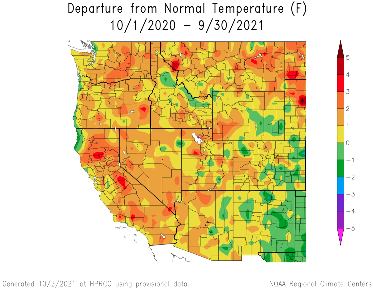
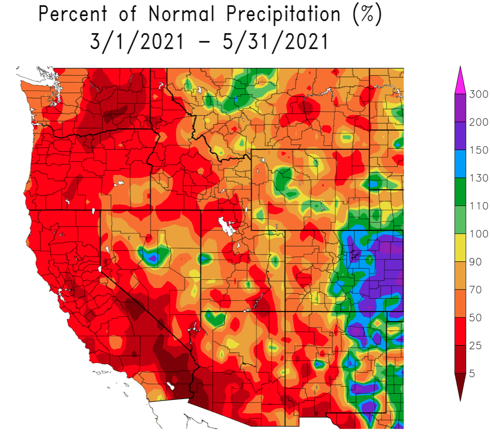
- Precipitation during the 2021 water year was below normal for most of the region, except for the Front Range and southeastern Colorado where precipitation was up to 120% of normal. Northwestern and southern Utah, southwestern and eastern Wyoming and northwestern Colorado received less than 70% of average precipitation. Temperatures were generally above normal in western Colorado, most of Utah, and southwestern and northeastern Wyoming. Temperatures were cooler than average in eastern Colorado and southeastern Wyoming. Summer temperatures were extremely hot in the Intermountain West in 2021; Utah saw the hottest June-August on record while Wyoming and Colorado experienced the 3rd and 4th hottest summers since 1895.

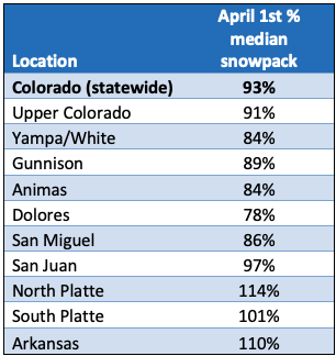
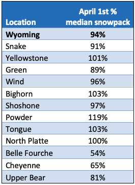
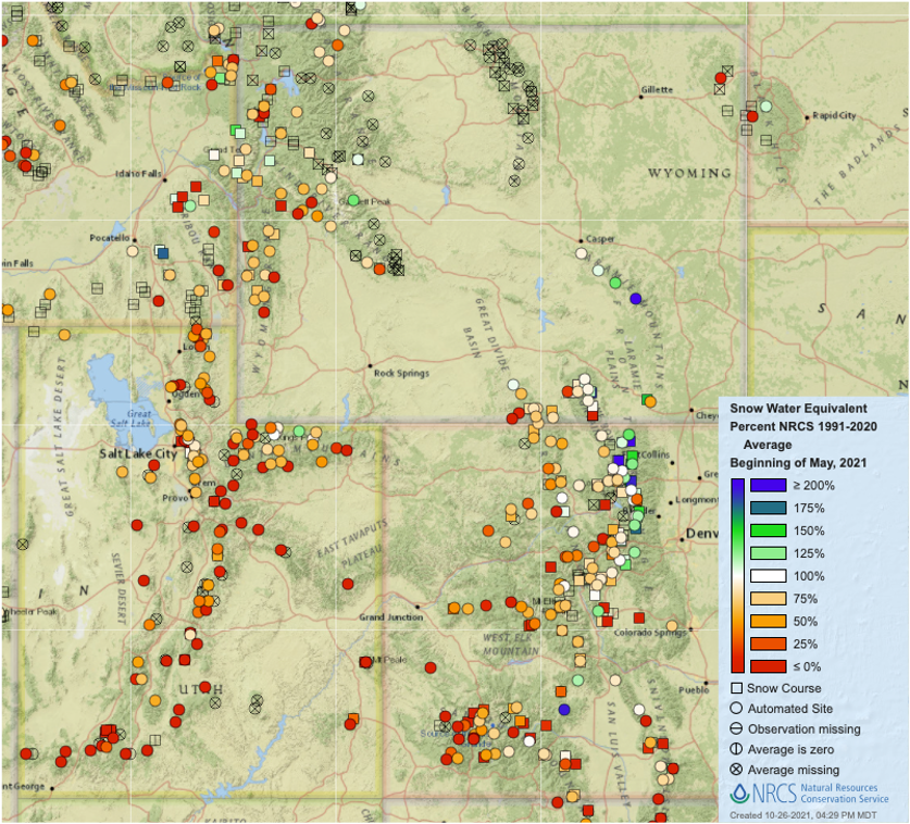
- Winter was slow to start regionally; January 1st 2021 snow water equivalent (SWE) was 50-80% normal in most locations. By April 1st, SWE was near average in Colorado (93% statewide average) and Wyoming (94%), but below average in Utah (79%). Snowmelt proceeded extremely quickly during April and May, especially in Utah and western Colorado; May 1st SWE was 52% of normal in Utah and 71% of normal in Colorado. One June 1st, SWE was 12% of normal in Utah and snow was completely melted from all but 3 sites compared to 17 sites with snow on a normal June 1st.

-
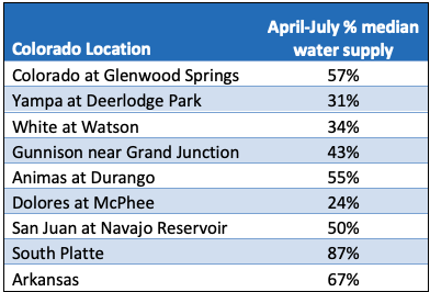
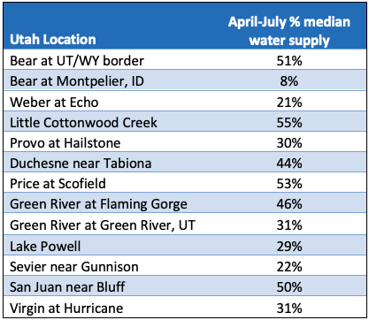
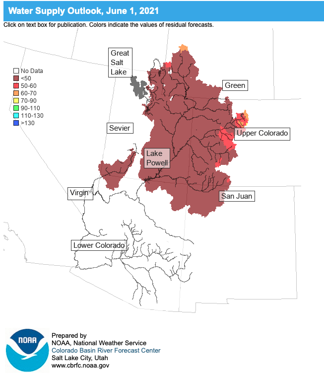
Much like the 2020 water year, streamflow volumes in the 2021 water year were significantly lower compared to average than snowfall. While April 1st SWE varied from 50-80% of normal in most locations, April-July streamflow volumes varied from just 8-57% at those same locations. The inflow to Lake Powell was 28% of normal in 2021. April-July streamflow volumes were closer to normal east of the Continental Divide where snowfall was near to slightly above normal. The 2021 water year produced an inefficient runoff for all river basins in the Intermountain West similarly to the 2020 water year. Streamflow volume forecasts were very low on April 1st at <60% of normal runoff for most of the region. Warm temperatures, dry soils and below average spring precipitation led to a very fast snowmelt in Utah and western Colorado.
-
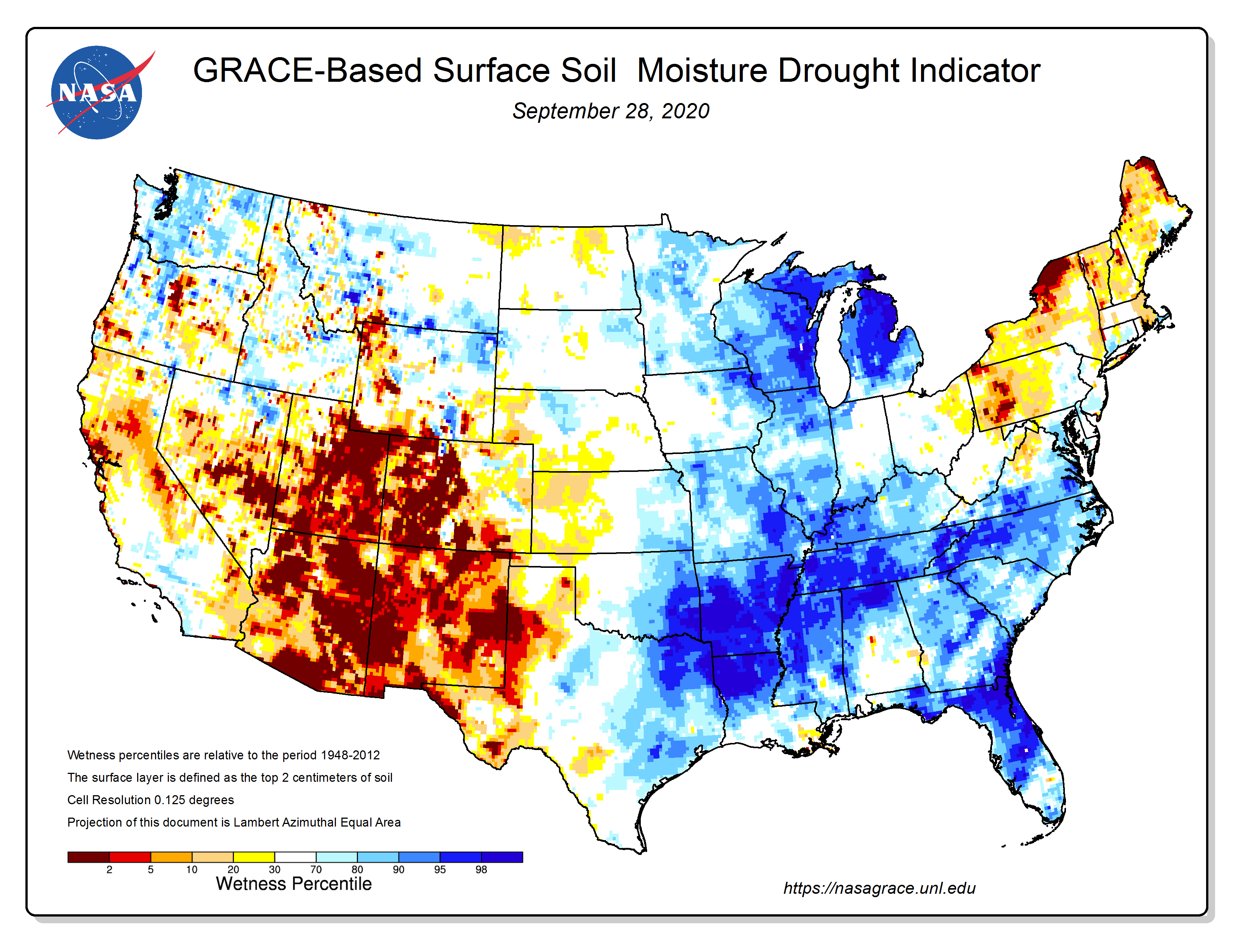
By June 1st seasonal streamflow volume forecasts predicted <50% of normal runoff for nearly the entire Upper Colorado and Great Basins. One cause of inefficient runoff during 2021, was extremely low soil moisture to begin the water year. October 1st 2020 soil moisture values were very low in Utah, western Colorado and parts of western Wyoming. Soils in large areas of Utah and western Colorado were at the lowest moisture levels observed (since 1948) to start a water year. Very low October 1st soil moisture meant that melting snow in spring needed to first recharge soil moisture reservoirs before snowmelt could reach regional rivers.
-
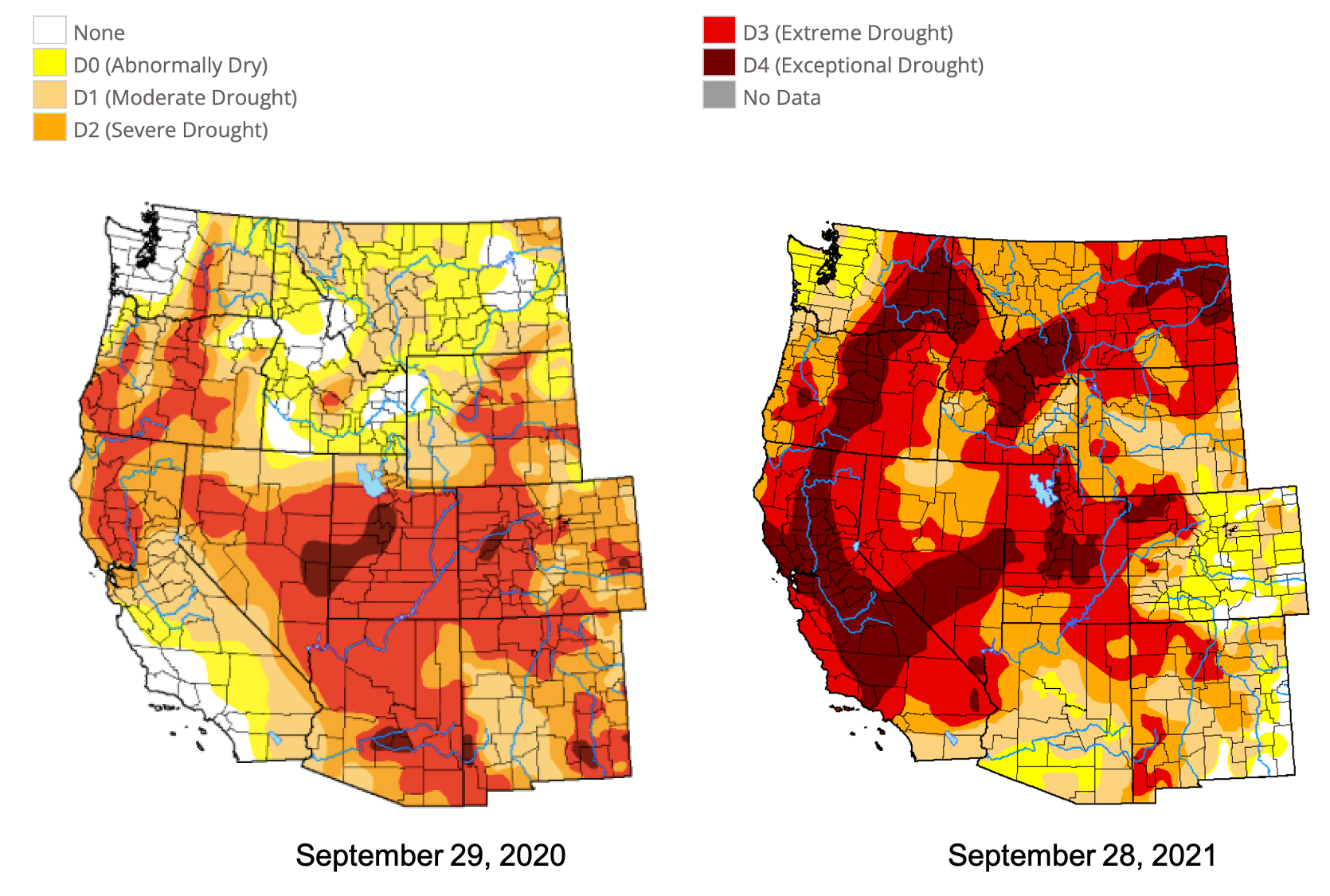
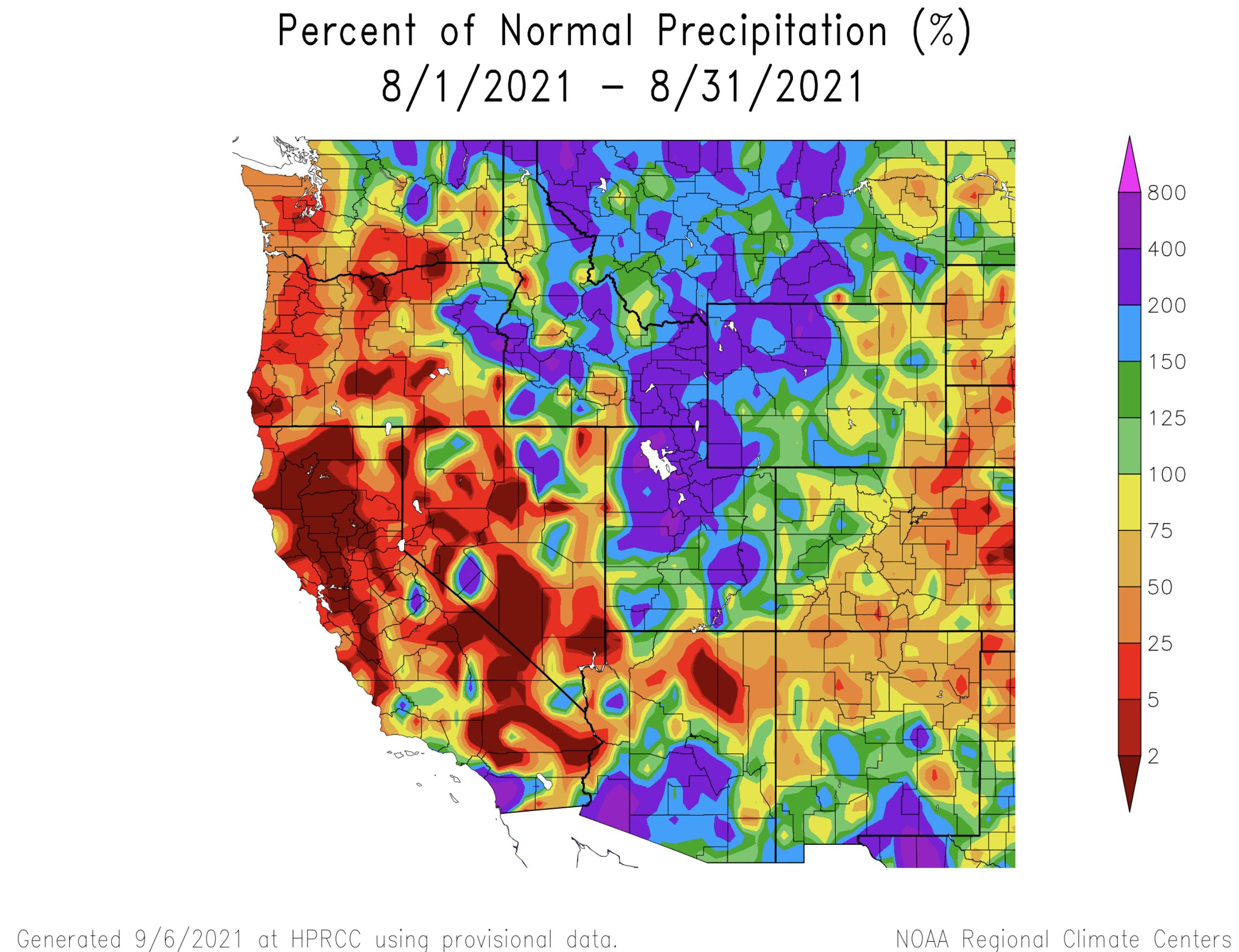
The 2021 water year was a year of extreme drought for the entire region. The water year began with 99% of the region in drought and over 50% of the region in extreme drought. The worst drought conditions were found in Utah; during July, when conditions were driest, 100% of the state was in at least extreme drought and 70% of the state was in exceptional drought. Two periods of rainfall outside of winter brought improvements to drought during 2021. Much above average precipitation during March – May 2021 in eastern Colorado led to the complete removal of all drought conditions east of the Continental Divide by June 1st. The wet period began on March 13th with a very large upslope snowstorm that brought 18 – 52” of snow to an area from the north slope of the Uinta Mountains east to Cheyenne, WY and south to Denver, CO. Except for eastern Colorado, drought conditions generally worsened throughout the region until mid-July when monsoonal precipitation began to push northward into southern Utah and southwestern Colorado. Strong monsoonal precipitation continued into August when Utah, western Wyoming and northwestern Colorado received above average precipitation; large areas of Utah and western Wyoming saw greater than 200% of normal August precipitation with some locations breaking monthly rainfall records. The 2021 water year closed with some improvements to the severity of drought compared to the beginning of the water year; regional coverage of D1-D3 drought decreased by 10-20%.

-
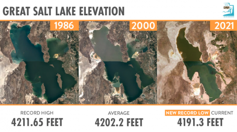
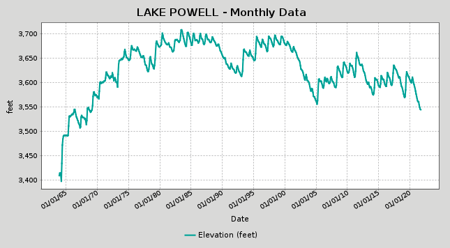
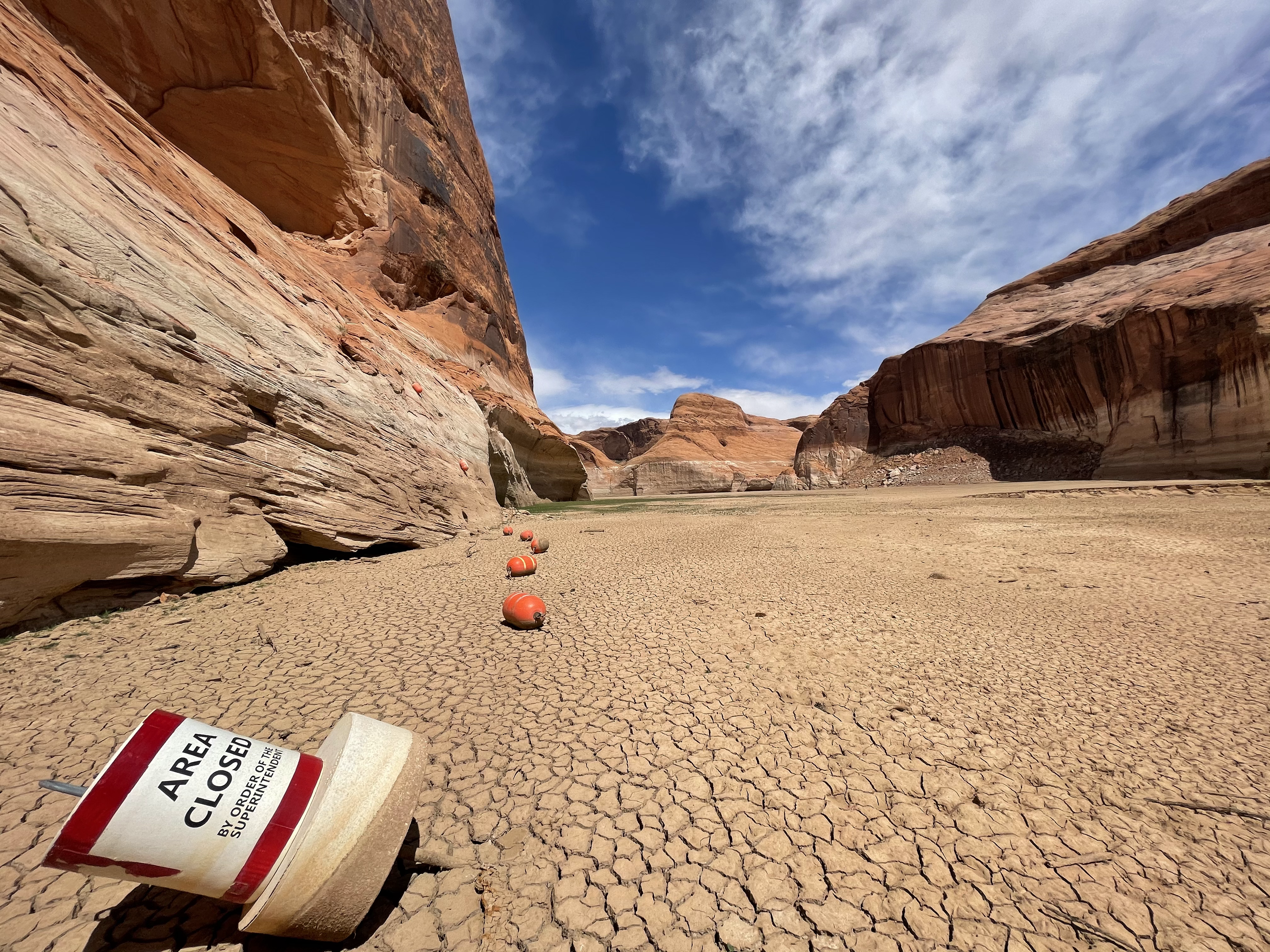
Monsoonal rainfall during July and August did improve drought conditions, but the region is far from recovered from drought. One impact of long-term drought is reflected by the amount of water in large reservoirs and terminal lakes. Both Lake Powell and the Great Salt Lake reached all-time low elevations during summer 2021. During August, Lake Powell reached a new record-low elevation of 3,551 feet above sea level; Lake Powell is currently at an elevation of 3,544 feet, 29% full and is expected to fall another 30 feet before spring runoff begins. The Great Salt Lake is a terminal lake in northern Utah that marks the end of the Bear, Weber and Provo/Jordan Rivers. Because it is a terminal lake, its elevation is a function of water inputs and water withdrawals. Drought, climate change and human consumption of water have led to a long-term decline in the Great Salt Lake’s elevation and area. The lake reached an all-time low elevation during of 4,191.3 feet in August, about 20 feet below its all-time high elevation in 1986. Because the Great Salt Lake is such a shallow lake, the area of the lake fluctuates by nearly a factor of 3, ranging from an area of 965 square miles in 2021 to 2,395 square miles in 1986. Above average precipitation during August – October has kept Great Salt Lake elevations hovering around record low levels, but not consistently lower as predicted earlier in the summer.
Image Image
Image Image
Image