September 6, 2023 - CO, UT, WY
August began with heavy monsoonal precipitation in Utah and Wyoming and much of the region received above normal precipitation except for drier conditions in parts of Colorado. August temperatures were near-normal for most of the region, but above average temperatures were recorded in parts of Colorado. Normal to above normal streamflow continued throughout most of the region following much-above average seasonal runoff coupled with monsoonal rainfall. Drought slightly expanded in the region; however, Wyoming became drought-free as of mid-August. The moderate El Niño in place has strengthened in the Pacific Ocean and is expected to continue through winter. NOAA seasonal forecasts for September suggest an increased probability of above average precipitation in Utah, below average precipitation in Colorado, and above average temperatures for the entirety of the region.
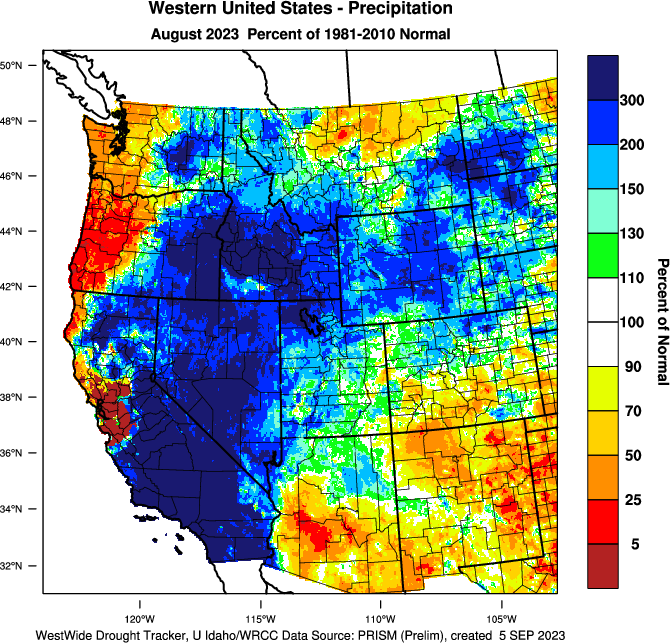
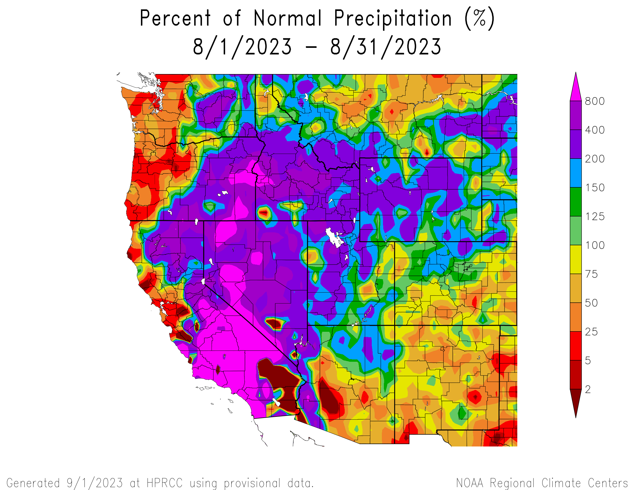
August precipitation was above to much-above normal for much of the region, except for southern and eastern Colorado where precipitation was below normal. Much-above normal precipitation occurred throughout much of Utah and Wyoming, ranging from 200-400% of normal precipitation with pockets of 400-800% of normal precipitation in Tooele and Box Elder Counties in Utah. A mix of wet and dry conditions occurred in Colorado, with wetter conditions in the Front Range and northern mountains and drier conditions throughout the eastern plains and southern mountains. Pockets of much-above normal precipitation fell in Larimer, Weld, and Logan Counties, and a pocket of much-below normal precipitation fell in Pueblo County.
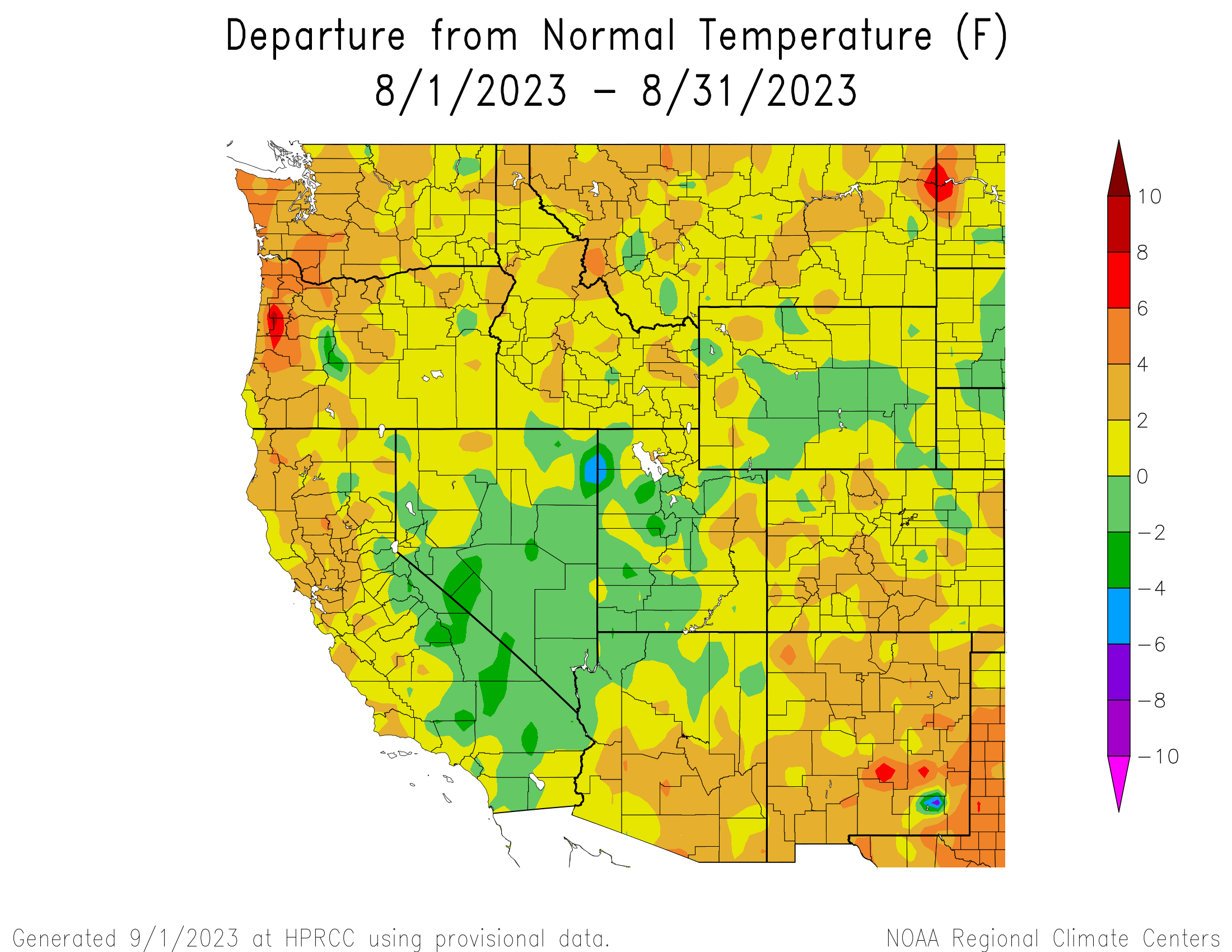
Temperatures in the Intermountain West were mostly near-normal in August, with above normal temperatures scattered throughout, particularly in Colorado. Near-normal temperatures were observed in almost the entirety of Utah and Wyoming. Exceptions include pockets of above normal temperatures in eastern Utah and western Wyoming and pockets of below normal temperatures in western Utah where temperatures were up to 4-6°F below normal at the western edge of Tooele and Box Elder Counties. Colorado also experienced near-normal temperatures throughout much of the state; however, temperatures were 2-4°F above normal in the central to southern mountains.
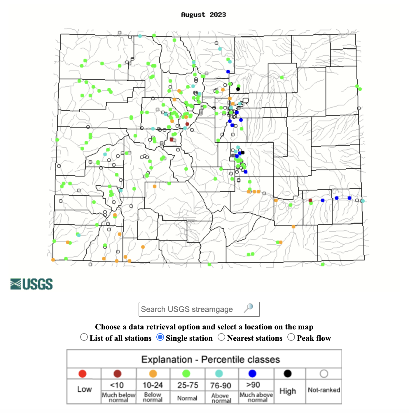
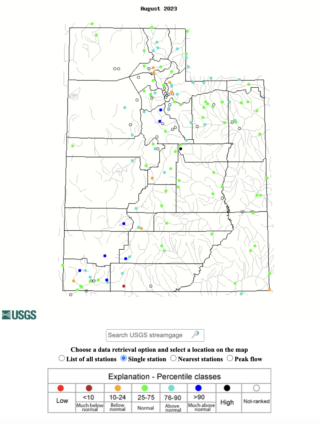
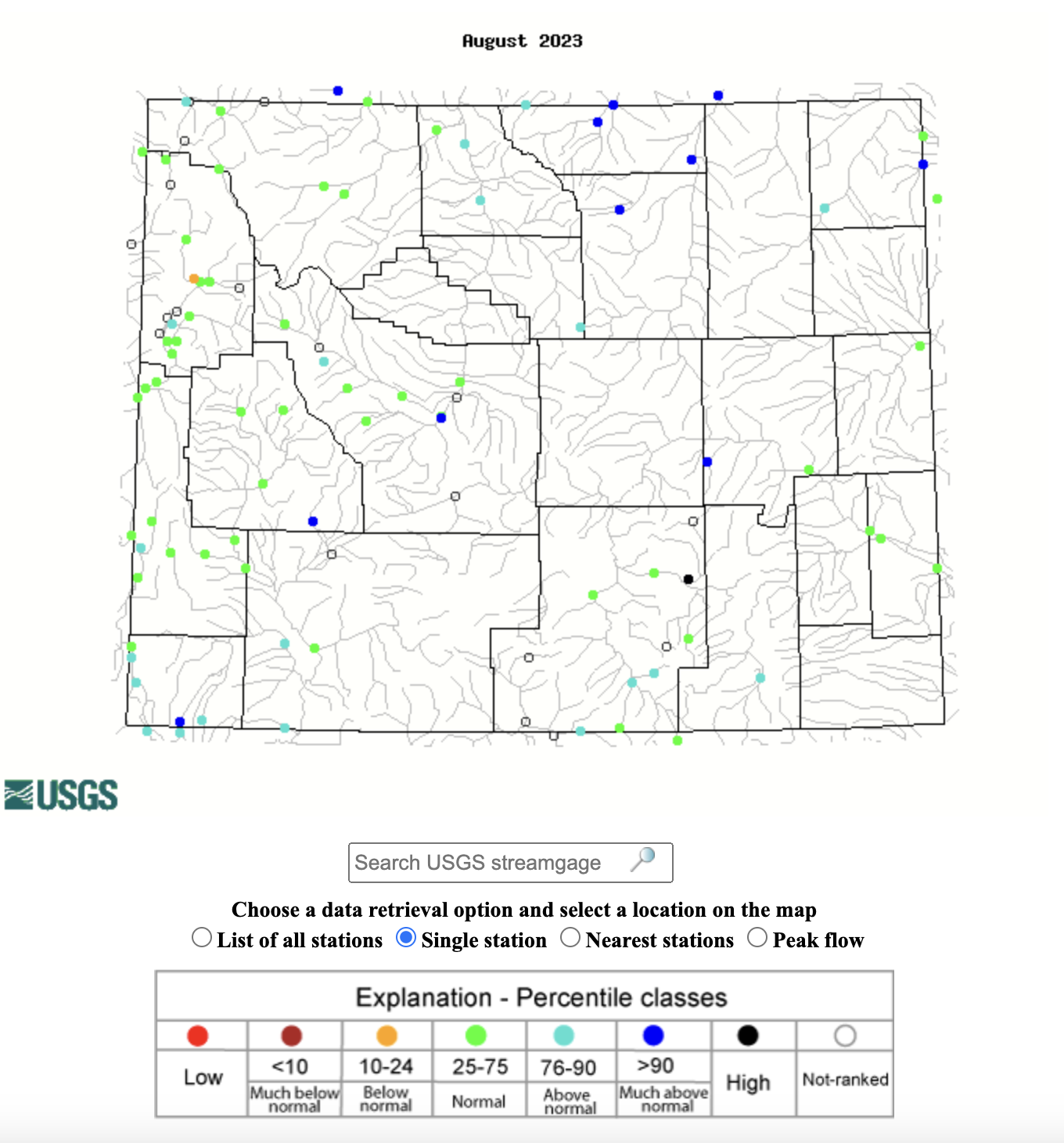
Normal to above normal streamflows were observed throughout the region during August, with much-above normal flows observed in each state and below normal flows at many sites in Colorado. Much-above normal streamflow occurred in the Provo, Beaver, Santa Clara, and North Fork Virgin Rivers in Utah; the Powder, Little Wind, Big Sandy, and Blacks Fork Rivers in Wyoming; the Big Thompson and Arkansas Rivers in Colorado. High flows (>95%) occurred at one site in Colorado, Utah, and Wyoming. Much-below normal streamflow occurred at one stream gauge in Utah and three gauges in Colorado including along the Arkansas and Blue Rivers.
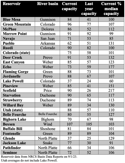
Most regional reservoirs continue to be full, nearly full, or have above average storage capacity. Statewide, Colorado reservoirs are 75% full and 101% of normal capacity. Last year, Colorado reservoirs were 58% full and at 78% of normal capacity. Reservoirs in Utah are also storing significantly more water than last year and are currently 88% full, which is 110% of normal capacity. Last year, Utah reservoirs were 57% full and at 81% of normal capacity. The notable exception to reservoir drought recovery, yet again, is Lake Powell, which remains only 37% full and 60% of median capacity despite above normal inflow this runoff season. Another exception is Navajo Reservoir on the San Juan River which is currently 71% full and at 85% of median capacity.
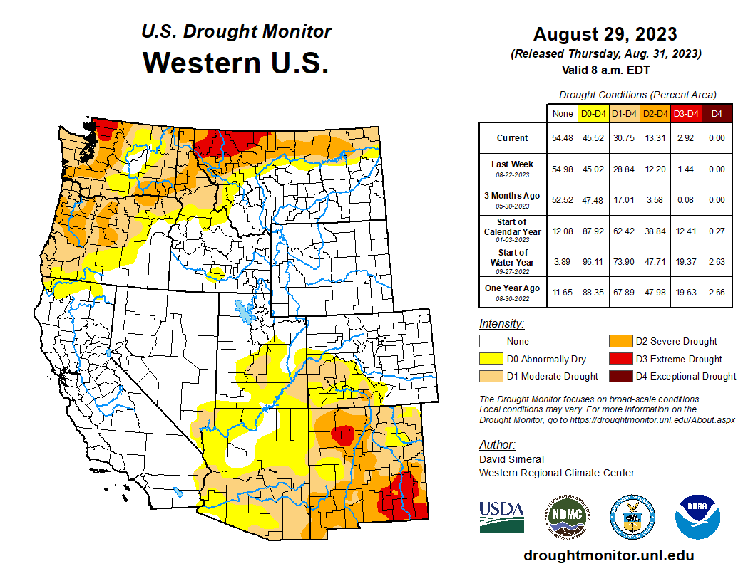
Regional drought coverage increased slightly to cover 9% of the region. However, further improvement of drought conditions in Wyoming was due to much-above normal August precipitation and now the state is drought-free. Much-above normal precipitation in Utah also helped shrink drought coverage by about 4%. In Colorado, drought coverage expanded in the Southwest with development of D2-D4 drought in Rio Grande, Alamosa, Conejos, and Costilla Counties.
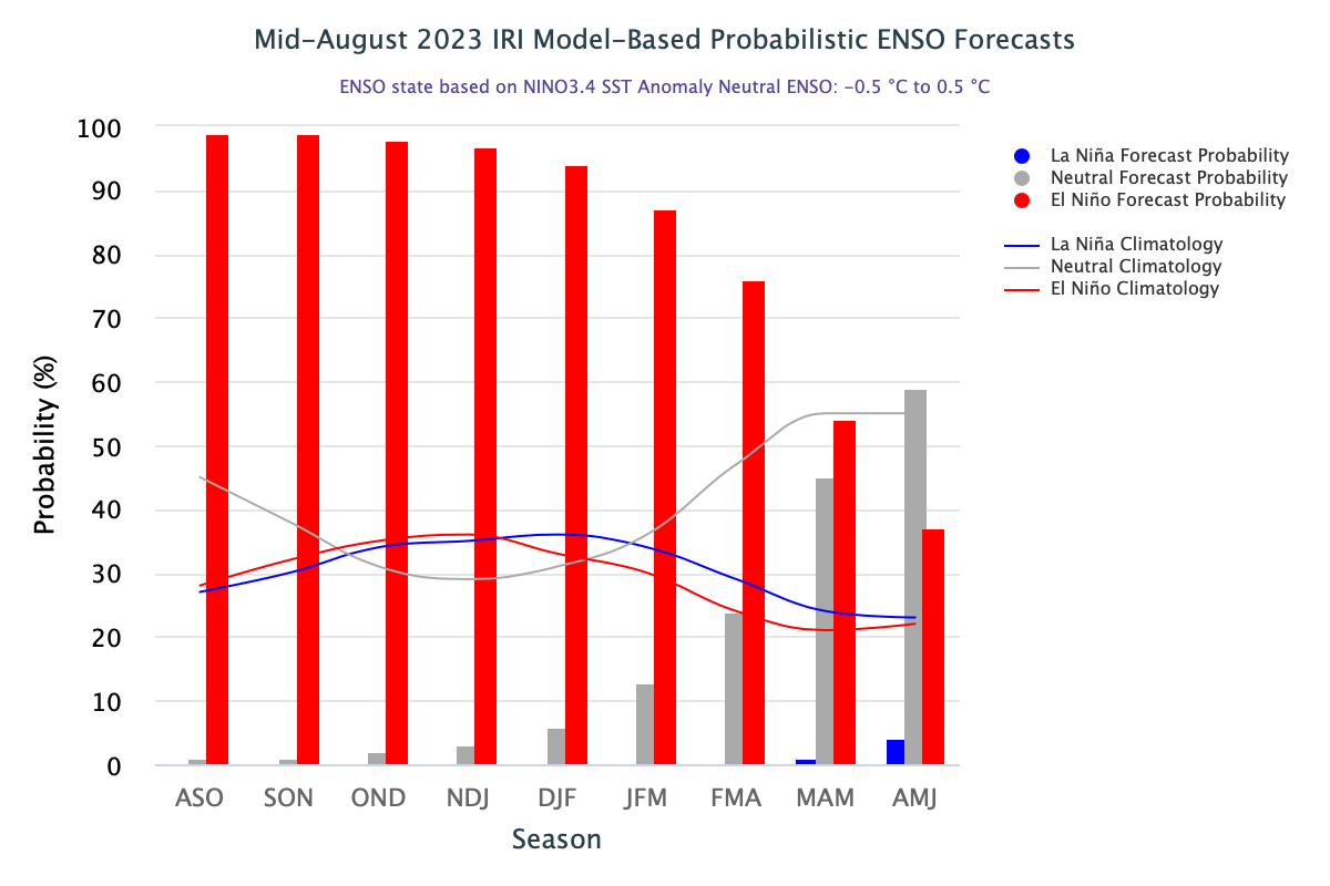
Moderate El Niño conditions developed during August as sea-surface temperatures in the central-eastern Pacific continued to warm. It is extremely likely that El Niño conditions will remain through winter with over a 90% probability of El Niño persisting through January and above 80% chance of it continuing into March. By April, there are 50/50 odds of El Niño or neutral conditions and by May, the probability of neutral conditions increases to almost 60%. NOAA seasonal forecasts for September predict an increased probability of above average precipitation in southwestern to central Utah and below average precipitation in eastern Colorado, particularly in the southeastern portion of the state. Above average temperatures are forecasted for the entirety of the region in September, with increasing probabilities moving eastward in the region. During September-November, NOAA seasonal forecasts predict an increased probability of above average temperatures throughout the region.
Significant August weather event. A wet and tropical August. Much of Utah and Wyoming received over 150% of normal August precipitation and large areas received 200-400% normal August precipitation. High regional precipitation was driven by an early August surge of monsoonal moisture (8/1-8/9) and the remnants of Hurricane Hilary (8/20-8/23). In Wyoming, it was the 2nd wettest August in Pinedale, 3rd wettest in Dubois, 4th wettest at Old Faithful, and the 5th wettest in Buffalo and Sheridan. Near-record wet conditions were also observed in many Utah cities; it was the wettest August ever in Grantsville, the 3rd wettest in Brigham City and Ogden, and the 5th wettest in Logan and Salt Lake City. Daily rainfall records were broken at many long-term monitoring sites in Utah from 8/1-8/5 and in Wyoming from 8/1-8/9. In Utah, the wettest August week on record was observed in Grantsville (3.59”), Pleasant Grove (2.26”), and Trenton (2.61”); two daily records at each site were also broken during the record-wet week of 8/1-8/7. In Wyoming, Wamsutter experienced its wettest August week on record as 1.9” of rain fell from 8/2-8/8. During the first 9 days of August, 57 daily rainfall records were broken in Wyoming (at sites with > 50 years of data). Many locations observed multiple new daily rainfall records during early August. In Dubois, daily rainfall records were set on four days; in Story, three new daily rainfall records were set, and daily rainfall records were broken twice at 12 additional sites.