September 2, 2022 - CO, UT, WY
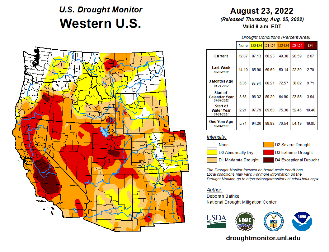
August brought several waves of monsoonal thunderstorm to Colorado, Utah and western Wyoming and left much of the region with above average August precipitation. Monsoonal thunderstorms triggered high flows and flash floods in many locations. On August 20th, 1-2” of rain in Moab triggered a large flash flood that caused Mill Creek to crest its banks and flow down Main Street. Temperatures were near average for much of Colorado and Utah; temperatures in Wyoming, northern Colorado and northern Utah were 2-4 degrees above normal. Drought conditions improved slightly in Utah and Colorado and Utah remains the hardest hit by drought with 100% of the state in drought and 61% of the state in D3-D4 drought. La Niña conditions are predicted to persist through early winter and temperatures are likely to be above average and precipitation below average for much of the region.
Much of the region received average to above-average precipitation during August. Areas that traditionally receive ample monsoonal moisture like the Colorado Rockies and eastern Utah received average to slightly above average August precipitation. Large swaths of western and northern Utah and western Wyoming received 150-400% of normal August precipitation. August is typically a very dry month in these areas, so it is important to note that much above average precipitation meant total precipitation of 1-3 inches with isolated observations of 4 inches. There were three distinct areas of below average precipitation during August: eastern Colorado and Wyoming, northeastern Utah, northwestern Colorado into central Wyoming and the Lake Powell region.

August temperatures cooled somewhat compared to record and near-record July heat. Temperatures in most of Colorado and Utah were near-normal with areas of relatively cooler temperatures in the southern parts of both states. In parts of northern Colorado and Northern Utah, temperatures were 2-4 degrees above normal. In Wyoming, August temperatures were 2-4 degrees above normal in most locations.

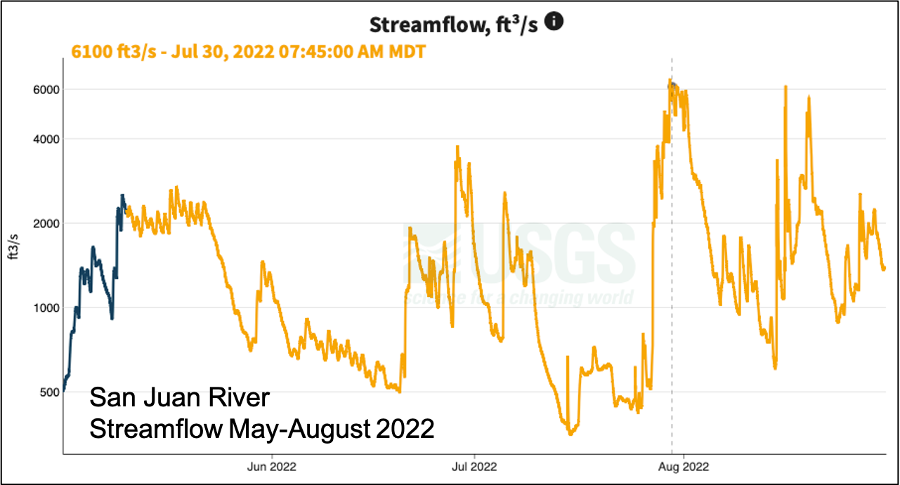
Several streams and rivers in central Utah continued to report record low monthly streamflows during August. In other locations, monsoonal rains caused many regional rivers to rise to above or much-above normal flows for short periods. Southern Utah rivers where flash floods occurred and flows rose to at least 1,000 cubic feet per second (cfs) included the Dirty Devil, Dolores, Paria, Price, Santa Clara and San Juan Rivers. Flows in the San Juan River were much higher than normal in August, including a peak flow of 6,000 cfs. The San Juan had a paltry peak spring streamflow of around 2,000 cfs, flows followed by a low of 350 cfs in late June.
The impacts of long-term drought are evident in regional reservoir storage, especially in the Colorado River Basin. Of the Upper Colorado River basin reservoirs, Flaming Gorge (75% full) and Fontanelle (92%) have the most stored water and Lake Powell remains extremely low (26% full). Navajo (55%) and Blue Mesa (41%) are also much lower than average for this time of year. Overall reservoir storage in Utah is below average and slightly lower than last year; Utah reservoirs are currently 62% full and 82% of median reservoir levels. Reservoir storage is slightly lower in Colorado where statewide reservoir storage is 56% full and at 75% of median reservoir storage. Colorado reservoir storage is highest in the South Platte River basin and Colorado River headwaters and the lowest levels of Colorado reservoir storage are found in the Gunnison and San Juan River basins.
Overall, regional drought conditions improved somewhat during August. Drought now covers 68% of the region (down from 73% on 8/2) and 21% of the region is in extreme (D3) drought, most of which is in Utah. Drought conditions improved by one category in southern and eastern Utah during August. In Wyoming drought conditions worsened by one category in south central Wyoming and southwestern Wyoming where extreme (D3) drought emerged. While monsoonal rains did improve drought conditions during August, conditions did not improve in as widespread of an area as predicted last month.
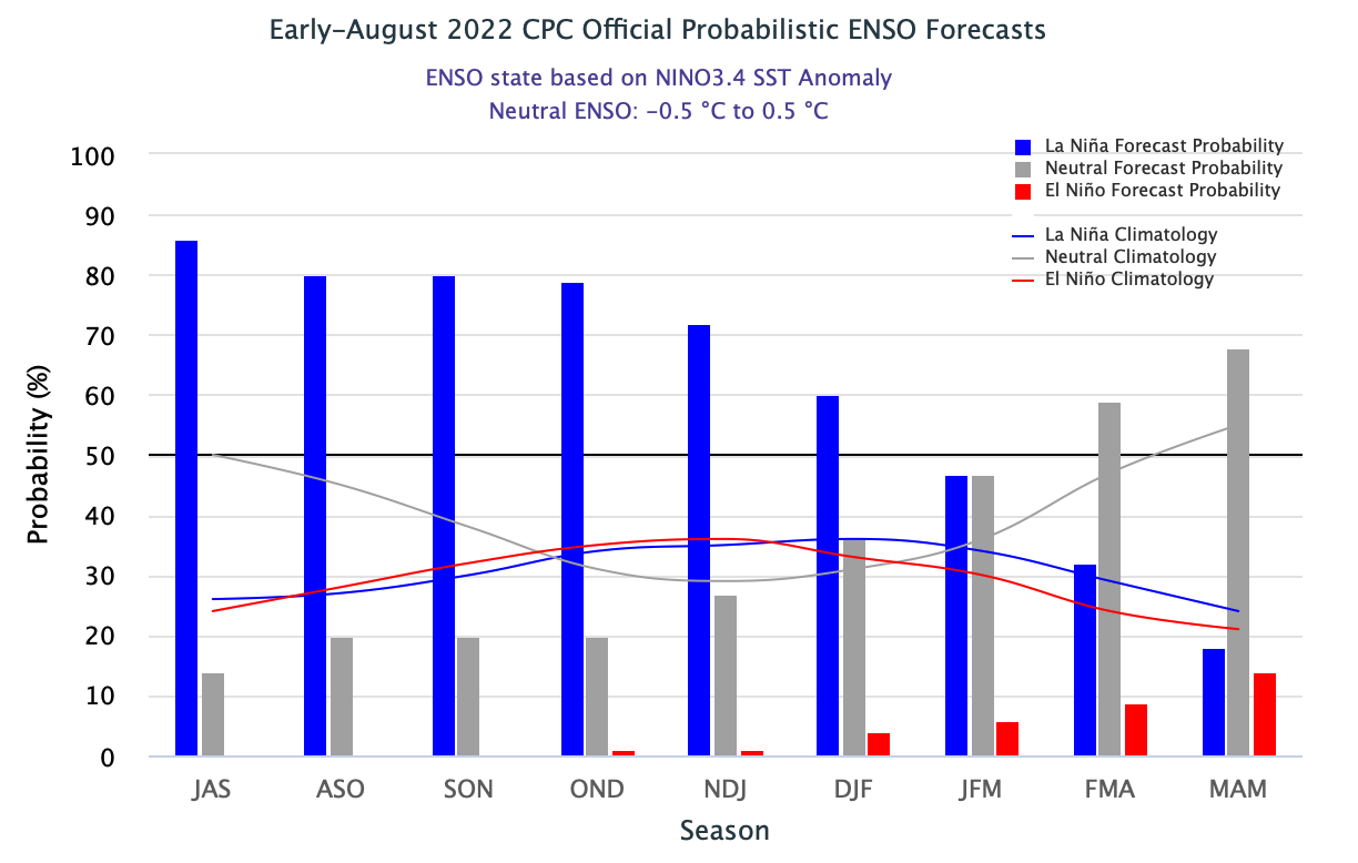
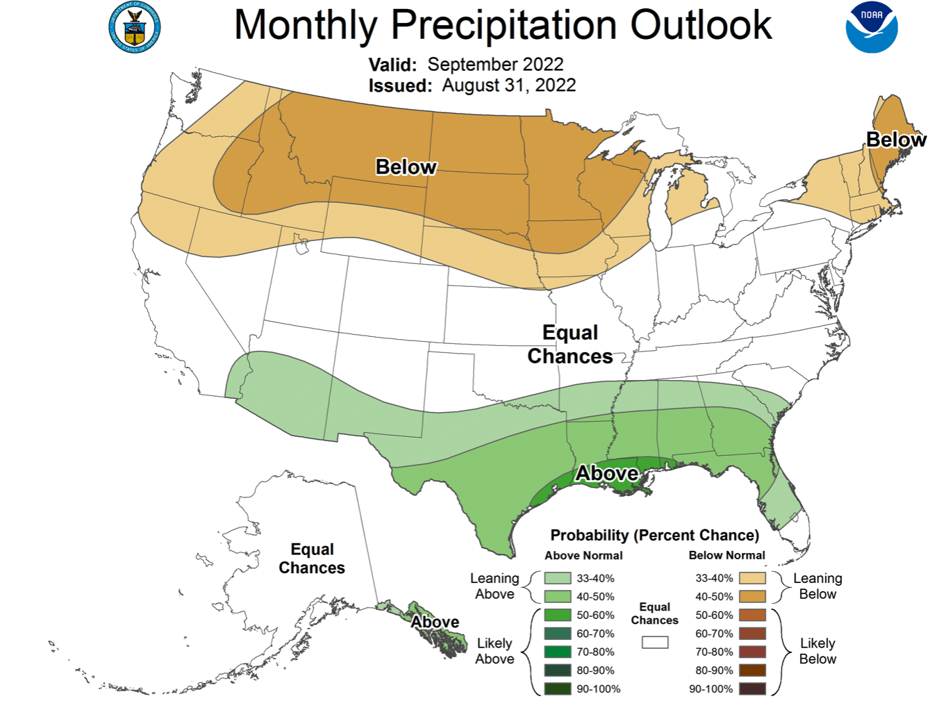
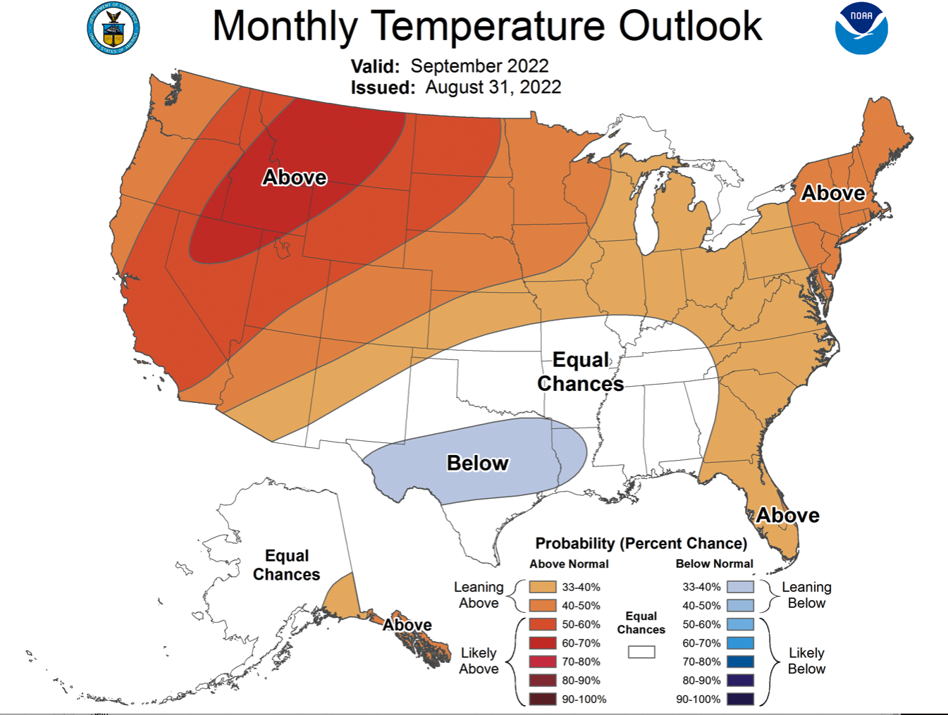
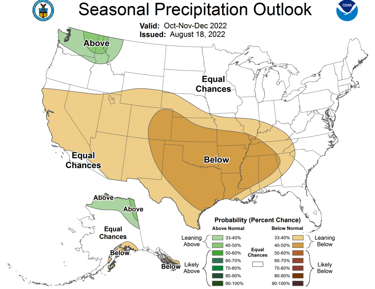
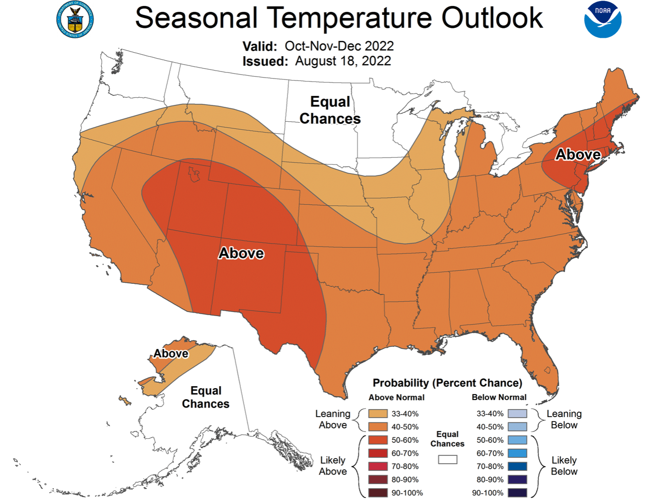
La Niña conditions remain in place as eastern Pacific Ocean temperatures remain consistently 0.5º - 1ºC below normal. There is a 60-85% probability of La Niña conditions remaining through mid-winter. By early 2023, there is a higher probability of neutral ENSO conditions and a 20-45% chance of La Niña conditions persisting. NOAA monthly climate outlooks project a 33-60% chance of above average regional temperatures and an increased probability of below average precipitation in Wyoming. The NOAA seasonal climate outlook for October-December indicates the influence of a La Niña weather through early winter with an increased probability of above average temperatures across the region and an increased probability of below average precipitation for Colorado, Utah and southern Wyoming.
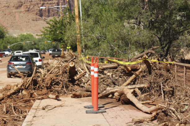
Significant August weather event. Strong monsoonal thunderstorms caused flash flooding and extensive damage in Moab, UT and a hiker fatality in Zion National Park. On August 20th, 1 to 1.75 inches of rain fell in the Mill Creek watershed southeast of Moab, UT. The ensuing flash flood tore down Mill Creek, reaching a peak flow of over 1,000 cfs upstream of Moab. Mill Creek overflowed its banks and ran down Main Street in Moab reaching depths of 2-3 feet, carrying several cars, woody debris and mud through downtownUtah Governor Spencer Cox declared a state of emergency in Moab and plans to seek aid from FEMA There was an estimated $10 million in damages from the flood.
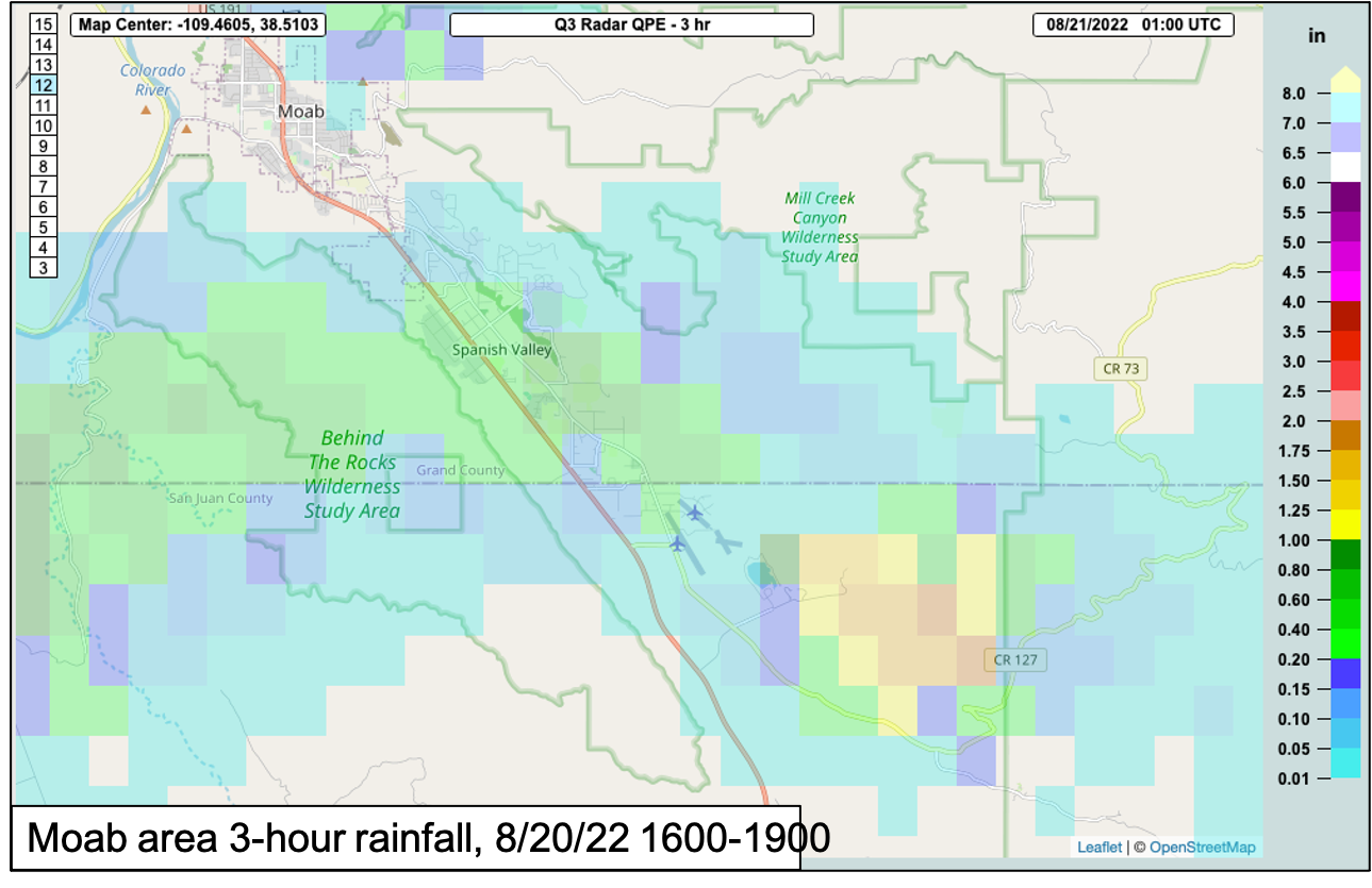
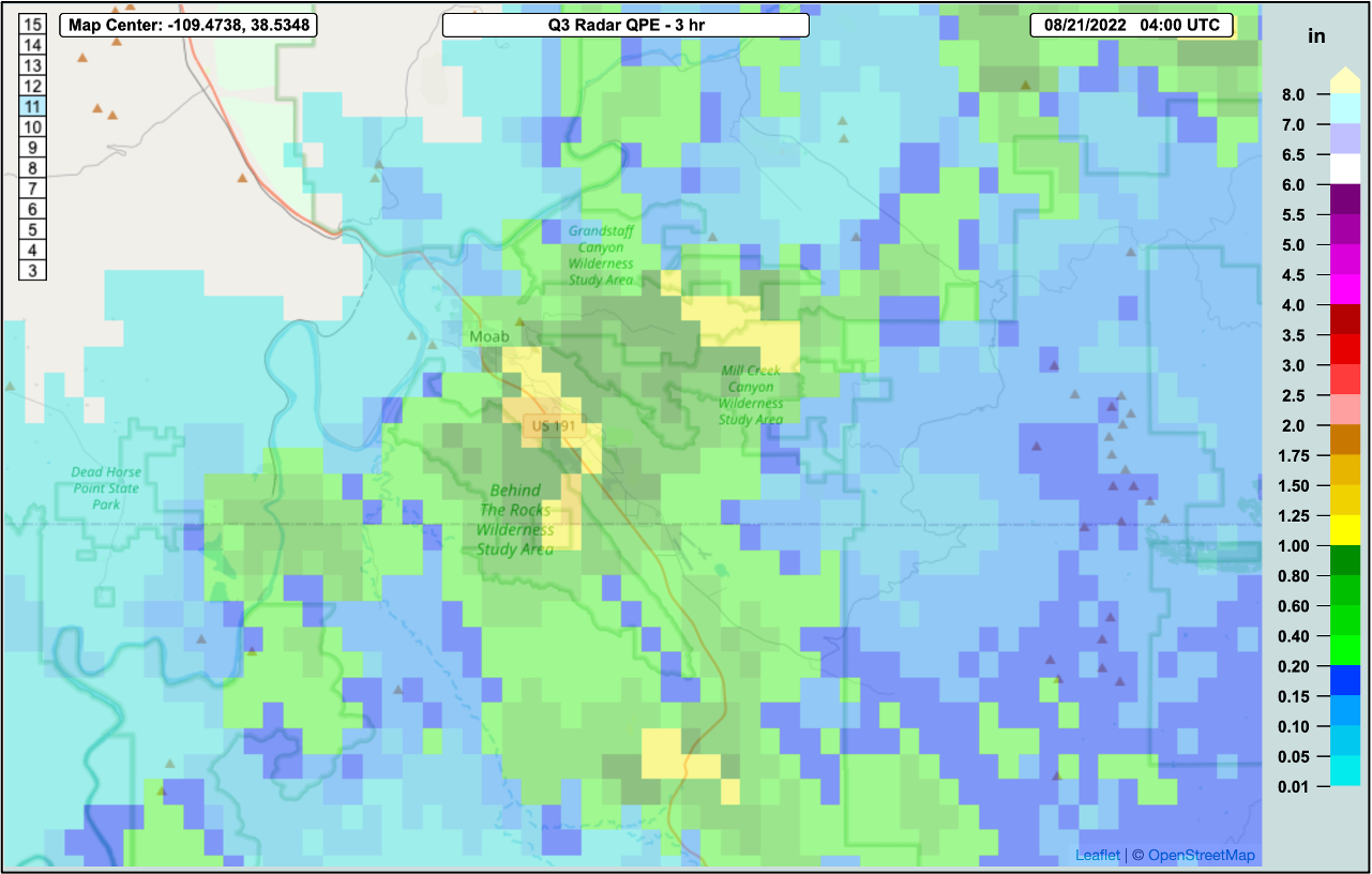
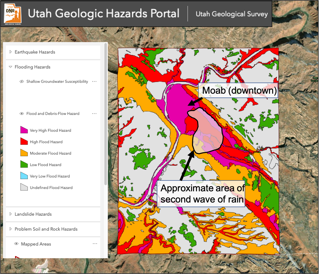
Area newspapers widely reported the flood as a 1-in-100-year event based on precipitation recurrence interval frequencies. The flash flood was actually caused by two distinct 1-in-100-year rainfall events in the Mill Creek watershed; one event started at 5:30 pm, the second event started at 6:40 pm and both lasted just over 1 hour. The rainfall event that triggered the initial high flows of 1,000 cfs in Mill Creek was from a small area of intense precipitation that stalled over Mill Creek upstream of Moab beginning at 5:30 pm. This area of rain dumped 1.25-1.75” of rain over 60-90 minutes. As Mill Creek flows were peaking at around 1,000 cfs, a second wave of precipitation arrived and dumped 1-1.5” of rainfall over Mill Creek immediately upstream of Moab. Mill Creek flows in downtown Moab, downstream of the streamflow gauge, were likely much higher than 1,000 cfs; most of the second wave of precipitation fell downstream of the Mill Creek stream gauge. Rainfall from the Moab area sites reported 0.03-0.64” of rain on 8/20. A potential contributor to the severity of the flood was the 2021 Pack Creek Fire which burned 8,000 acres in the upper Mill Creek watershed, however the most intense precipitation from the event did not occur over the Pack Cree Fire burn scar. The second wave of precipitation fell in an area rated as a high to very high flooding hazard according to Utah Geologic Survey maps.

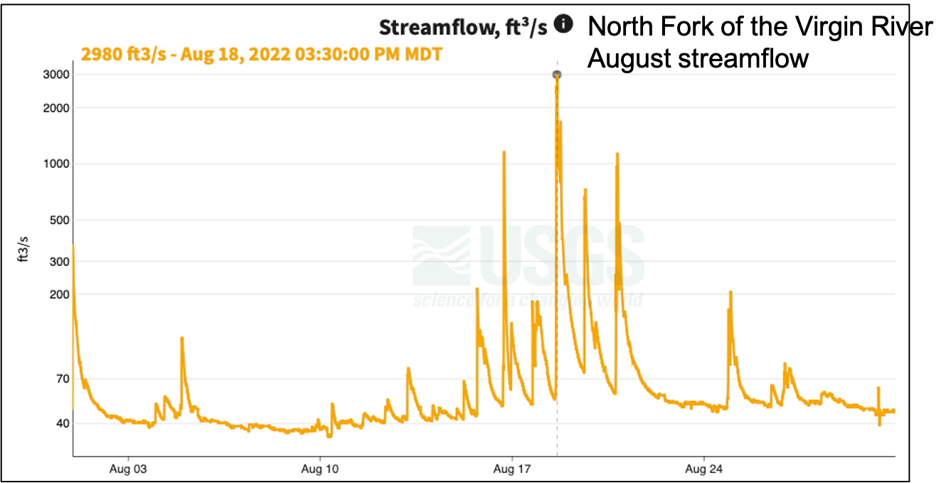
The day prior to the Moab flood, August 19th, a strong thunderstorm triggered a large flash flood in the Narrows of the Virgin River in Zion National Park. The Narrows is a popular hike in the park and particularly dangerous during times of high flash flood risk. Just downstream of the Narrows, on the North Fork of Virgin River, 0.67” of rain fell and the river peaked at a flow of 2,540 cfs. During the flash flood, there were several reports of hikers being swept off their feet or trapped by flood waters in the Narrows. Immediately following the flood, no hikers were unaccounted for, but by the evening of 8/19, a hiker from Tuscon, AZ was reported missing. Search efforts recovered the body of the 20-year-old woman on 8/23, approximately 6 miles downstream of the Narrows.