October 8, 2024 - CO, UT, WY
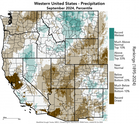
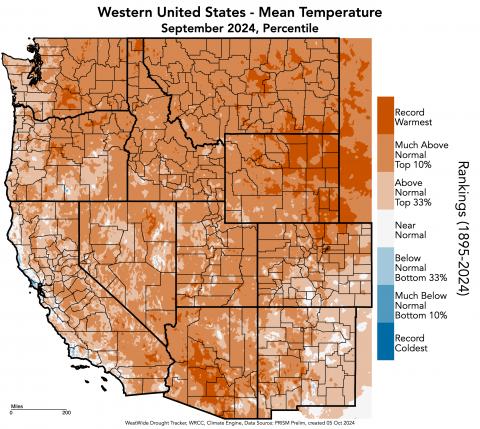
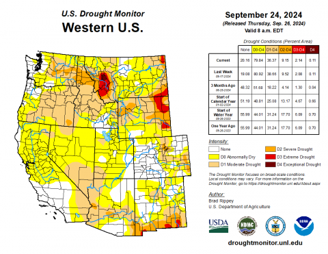
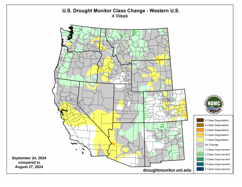
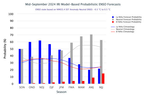
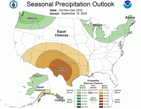
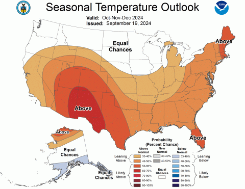
September precipitation was below to much below normal, particularly in Utah and Wyoming where record-dry conditions occurred. Temperatures were above to much above normal, breaking many record-warm temperatures in the region, particularly in Wyoming. Due to below normal precipitation and above normal temperatures in September, regional drought expanded by 7%, now covering 31% of the region. Neutral-ENSO conditions are transitioning into La Niña conditions with a 62% probability forecast that La Niña will develop by early winter. NOAA seasonal forecasts for October-December suggest an increased probability of below average precipitation and above average temperatures for the region.
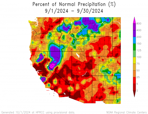
Regional precipitation during September was below to much below normal, with pockets of above normal precipitation in south-central and southeastern Colorado and northwestern Wyoming. Much below normal precipitation occurred throughout the majority of Utah and Wyoming, with exceptionally below normal (<2%) conditions in southern, western, and eastern Utah, and central Wyoming. Record-dry conditions were scattered throughout Utah and Wyoming with particularly large pockets in Tooele, Kane, and San Juan Counties in Utah.
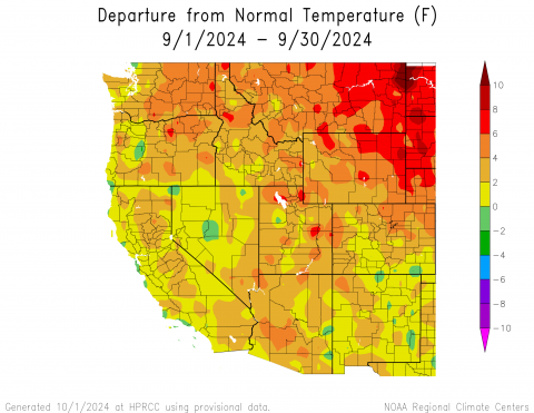
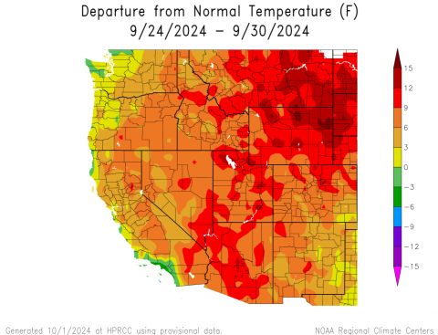
The region experienced at least 2-4°F above normal temperatures throughout the majority of the region in September, with large areas of 4-6°F above normal temperatures in each state. Pockets of 6-8°F above normal conditions were observed in Utah and Wyoming, with a large swath of these conditions in northeastern Wyoming. The greatest departure from normal temperatures was observed in a pocket of 8-10°F above normal conditions in Weston County, Wyoming. Record-warm temperatures occurred in a staggering amount of Wyoming, particularly in the eastern half of the state, as well as a large pocket from Denver up to Larimer and Weld Counties in Colorado.
The first accumulating snow fell across many mountain locations above 11,000 feet in Colorado on September 4. As of October 1, the highest amount of SWE is at Berthoud Summit in Colorado at 0.3 inches of SWE. Almost all other mountains in the region remain at 0 inches of SWE.
At the end of September, 31% of the region was covered by drought, a 7% expansion since the end of August. Wyoming experienced the most severe drought conditions, with D1 (moderate) drought expanding to 62% and D3 (extreme) drought conditions more than doubling in coverage up to 9% of the state’s area. D1 and D2 (severe) drought conditions both doubled in coverage in Colorado during September. Despite hot and dry conditions, drought coverage in Utah changed little during September.
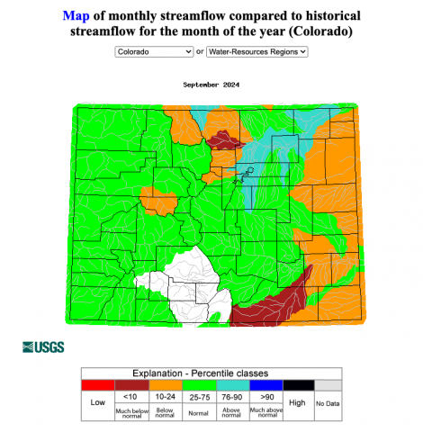
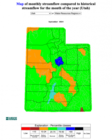
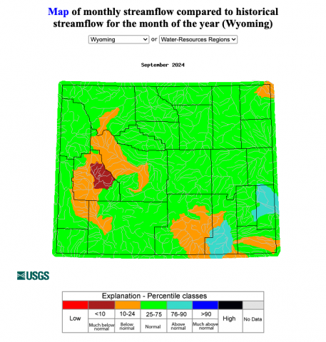
Streamflow in regional rivers was near to below normal during September. Much below normal streamflow occurred in the New Fork River basin in Wyoming, Big Thompson and Purgatoire River basins in Colorado, and the northern end of the Chinle River basin in Utah. Above normal streamflow occurred in the Wyoming portion of the North Platte River basin, the Upper Laramie River basin in Wyoming, the Colorado portion of the South Platte River basin, and the East Fork Sevier River basin in Utah. Lastly, much above normal streamflow occurred in the Spanish Fork River basin in Utah.
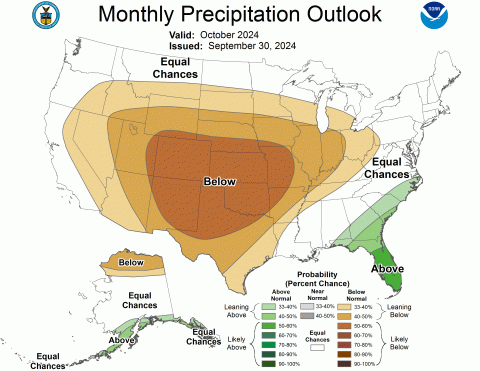
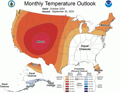
Near-to-below average sea surface temperatures were observed in the eastern Pacific Ocean, consistent with neutral-ENSO conditions. Current forecasts indicate a 62% probability of La Niña developing by December and a 59% probability of neutral-ENSO conditions returning by March. The NOAA monthly precipitation outlook for October suggests an increased probability of below average precipitation for the entire region, with below (50-60%) average conditions for all of Colorado. The monthly temperature outlook suggests an increased probability of above (60-80%) average conditions for the entire region. The NOAA seasonal outlook for October-December suggests an increased probability of below average precipitation for southern Utah and most of Colorado, and above average temperatures for the entire region, particularly in Colorado and Utah, with likely above (60-70%) average conditions in the Four Corners region.
Significant climate event: Late September heat wave. After cooler conditions during mid-September, a significant heat wave settled over the Intermountain West from September 25-30. The six-day period was the hottest on record for many weather monitoring sites with at least 50 years of data. All-time average high temperature records for September 25-30 were set at 28% of long-term weather monitoring sites in Colorado (29 of 105), 38% of sites in Utah (36 of 94), and 43% of sites in Wyoming (34 of 80). The September 25-30 heat was also significant because of the magnitude of heat across the region. The maximum temperatures reached during the heat wave included 104ºF in St. George, UT, 102ºF in Sheridan, WY, and 97ºF in Pueblo, CO, all of which were daily maximum temperature records. Several sites shattered the old all-time average maximum temperature record for September 25-30 including Gillette and Laramie, WY where the previous records were broken by 8.1ºF and 5.5ºF, respectively. During the heat wave, many sites set daily temperature records on multiple days. Across Colorado, Utah, and Wyoming, 17 sites set daily high temperature records on three days, 18 sites set daily temperature records on four days, and 4 sites set daily temperature records on four days. Two sites, Neola, UT, and Grand Junction, CO set daily high temperature records on all six days. Looking back to August predictions of temperature, the NOAA forecast for September correctly forecasted a 70-80% chance of above average temperatures during September. Across North America, a series of late September extreme weather events were interrelated, beginning with an anomalous atmospheric river event in northern British Columbia and southern Alaska which set up a ridging pattern that led to favorable conditions for the late September heat wave and then created conditions that interacted with Hurricane Helene in the southeastern United States.
