November 13, 2024 - CO, UT, WY
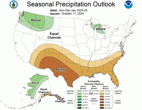
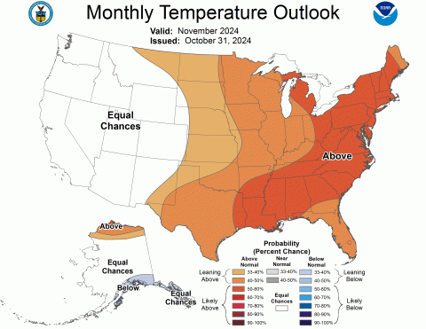
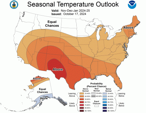
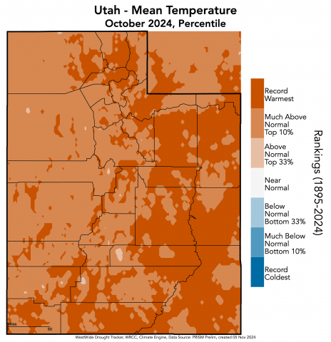
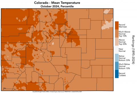
October precipitation varied widely across the region, particularly in Colorado with southern Colorado seeing above normal conditions and northern Colorado generally seeing below normal conditions. October temperatures were above to much above normal throughout the region, with Utah experiencing its warmest October on record and Colorado and Wyoming their second warmest. Regional snow-water equivalent (SWE) was variable, with the majority of Utah and southern Colorado observing above normal SWE and northern Colorado and Wyoming observing below normal SWE. By the end of October, drought conditions expanded since September, now covering 53% of the region. ENSO-neutral conditions continued in October and there is a 53% chance of La Niña conditions developing by early winter. The NOAA seasonal outlook for November-January suggests an increased probability of below normal precipitation for much of Colorado and southern Utah and above normal temperatures for the whole region.
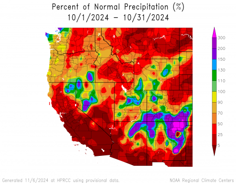
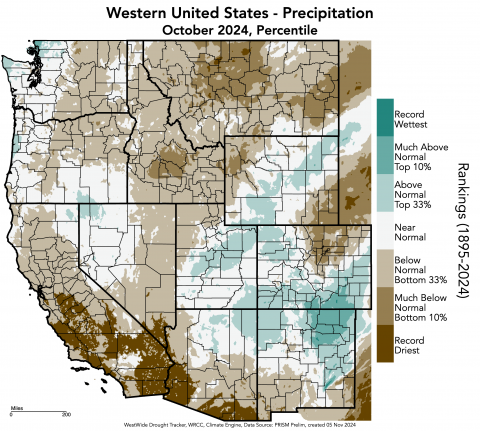
Regional precipitation was variable in October, ranging from above to below normal conditions in each state. Colorado experienced the widest variance of conditions, from as low as 5-25% of normal precipitation along the Front Range and in northeastern Colorado, to 200-300% of normal precipitation in southern Colorado. A small area in Las Animas County, Colorado experienced greater than 300% of normal precipitation. October precipitation was 5-25% of normal in southeastern Wyoming. October precipitation was in the bottom 10% of the period of record in northwestern and southeastern Wyoming as well as northern Colorado, while precipitation was in the top 10% of all years in southern Colorado.
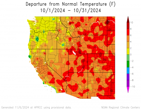
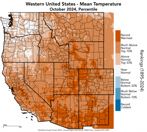
October temperatures were 4-8ºF above normal throughout the region. Pockets of 8-10°F above normal temperatures were observed in northern and eastern Utah, northern Colorado, and southern Wyoming. A few pockets of 2-4°F above normal temperatures occurred in each state, and one small pocket of near normal (0-2°F) temperatures occurred in Mineral County, Colorado. Large areas throughout the region experienced record-warm temperatures for October. Regionally, Utah experienced its warmest October on record, while Colorado and Wyoming had their second warmest. Additionally, many other states in the West experienced their warmest or second warmest Octobers on record, including Arizona, New Mexico, and Texas, and California and Montana, respectively.
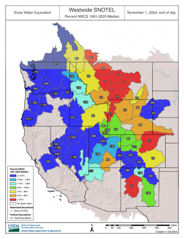
As of November 1, snow-water equivalent (SWE) was variable across the region. SWE was above normal for the majority of Utah, with much above normal conditions in the Upper Colorado-Dolores River (592%), Great Salt Lake (588%), and Jordan River Basins (204%). Much above normal SWE also was observed in southwestern Colorado and northeastern Wyoming basins. Below normal SWE was observed in the majority of Wyoming, with much below normal SWE in the Upper Yellowstone (41%) and Snake Headwaters Basins (41%). The South Platte Basin in Colorado also experienced much below normal SWE at 37% of normal. In Colorado, most SNOTEL sites reported 0-2" of SWE with a high of 6” at Beartown near Telluride. In Utah, most SNOTEL sites reported 0-1" of SWE with a high of 2.4” at Steel Creek Park in the Uinta Mountains. Lastly, in Wyoming, most SNOTEL sites reported 0-1" of SWE with a high of 2.3” at Bald Mountain in the Bighorn Mountains.
Note: Current SWE as a percent of normal maps are often skewed at this time of year due to the very low average SWE this early in the season.
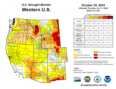
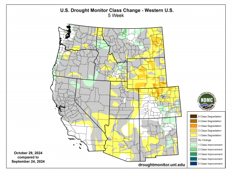
At the end of October, drought covered 53% of the region, up from 31% drought coverage in September. As of mid-October, drought conditions covered the entire state of Wyoming. Severe (D2) drought coverage more than doubled and extreme (D3) drought coverage tripled in Wyoming, and a small pocket of exceptional (D4) drought emerged in northeastern Wyoming. In Colorado, D1 drought coverage nearly doubled, D2 drought nearly tripled, and D3 drought emerged along the northern Front Range. Lastly, in Utah, D1 drought coverage doubled and D2 drought emerged in Washington County.
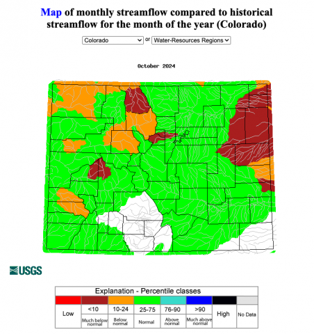
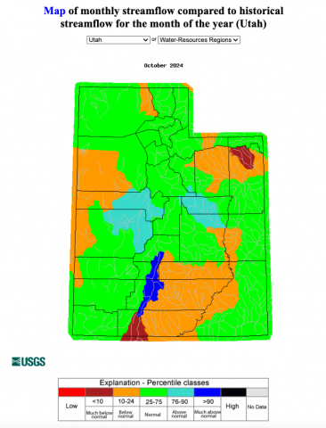
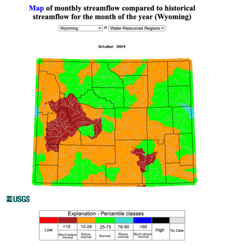
Regional streamflow conditions were near to below normal during October. Below normal streamflow conditions were observed in multiple river basins of each state with much below normal conditions in parts of the Gunnison, North Platte, South Platte, Republican, and Arkansas River Basins in Colorado; the Lower Green and Lower Colorado River Basins in Utah; and the Big Horn, Upper Green, and North Platte River Basins in Wyoming. Much above normal conditions were observed in the East Fork Sevier River Basin in Utah.
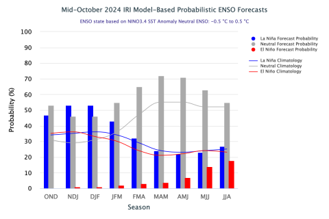
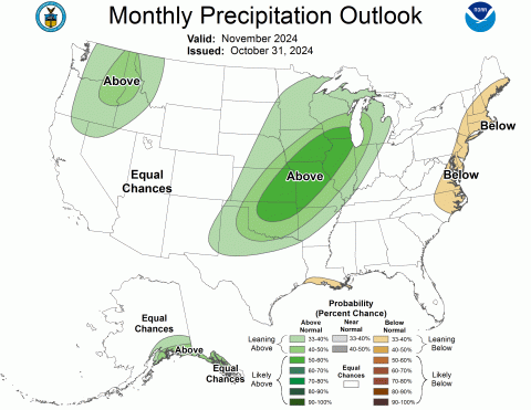
ENSO-neutral conditions continued during October with near to below average sea surface temperatures in the Pacific Ocean, which triggered a La Niña Watch from the NOAA Climate Prediction Center. There is a 53% chance of La Niña emerging by December and a 53% chance of it persisting through December-February. There is a 55% chance of ENSO-neutral conditions returning by January-March, according to the IRI Model-Based Probabilistic ENSO Forecast. Note, there is a discrepancy between the NOAA and IRI ENSO forecasts at this time. The NOAA seasonal outlook for November-January suggests an increased probability of below normal precipitation for southern Colorado and southeastern Utah, and above normal precipitation for northwestern Wyoming. There is an increased probability of above normal temperatures for the entire region, particularly in southern Colorado and southeastern Utah.
Significant climate event: Record October heat. Salt Lake City experienced its warmest October on record in 2024, with the first 16 days reaching 80°F or above. The average temperature for the month was 62.4°F, surpassing the previous record of 60.5°F set in 2015. Other Utah cities also saw record-breaking average temperatures: St. George at 69.9°F, Provo at 61°F, Fillmore at 60.7°F, Escalante at 60.6°F, Price at 58.6°F, Lehi at 57.9°F, Manti at 56.6°F, Park City at 52.9°F, and Alta at 47.1°F. Northern Colorado experienced very dry weather and significantly above normal temperatures as well, with only two days of measurable precipitation and 26 days of above normal temperatures. Colorado was on track to have its warmest October on record, but a cold front in the last two days caused the average monthly temperature to slip to the second warmest on record. In Denver, the mean October temperature was 59.1°F, which was 8.0°F above normal, making it the second warmest October on record. Precipitation was much below average at 0.11 inches, which is 0.88 inches below normal. No snow was observed, which is 3.9 inches below the average October snowfall.
