May 5, 2022 - CO, UT, WY
April precipitation and temperature was strongly influenced by La Niña with cooler temperatures and above average precipitation in Wyoming and warmer temperatures and below average precipitation in much of Colorado and Wyoming. On a statewide basis, peak snowpack in Colorado and Utah occurred in late March, but snowpack continued to increase in much of Wyoming through April. May 1st seasonal streamflow forecasts are below to much-below normal in the Upper Colorado River and Great Basins. As drought continues in 94% the entire region and reservoir storage is below normal at most locations, water supplies will likely be strained during summer 2022.
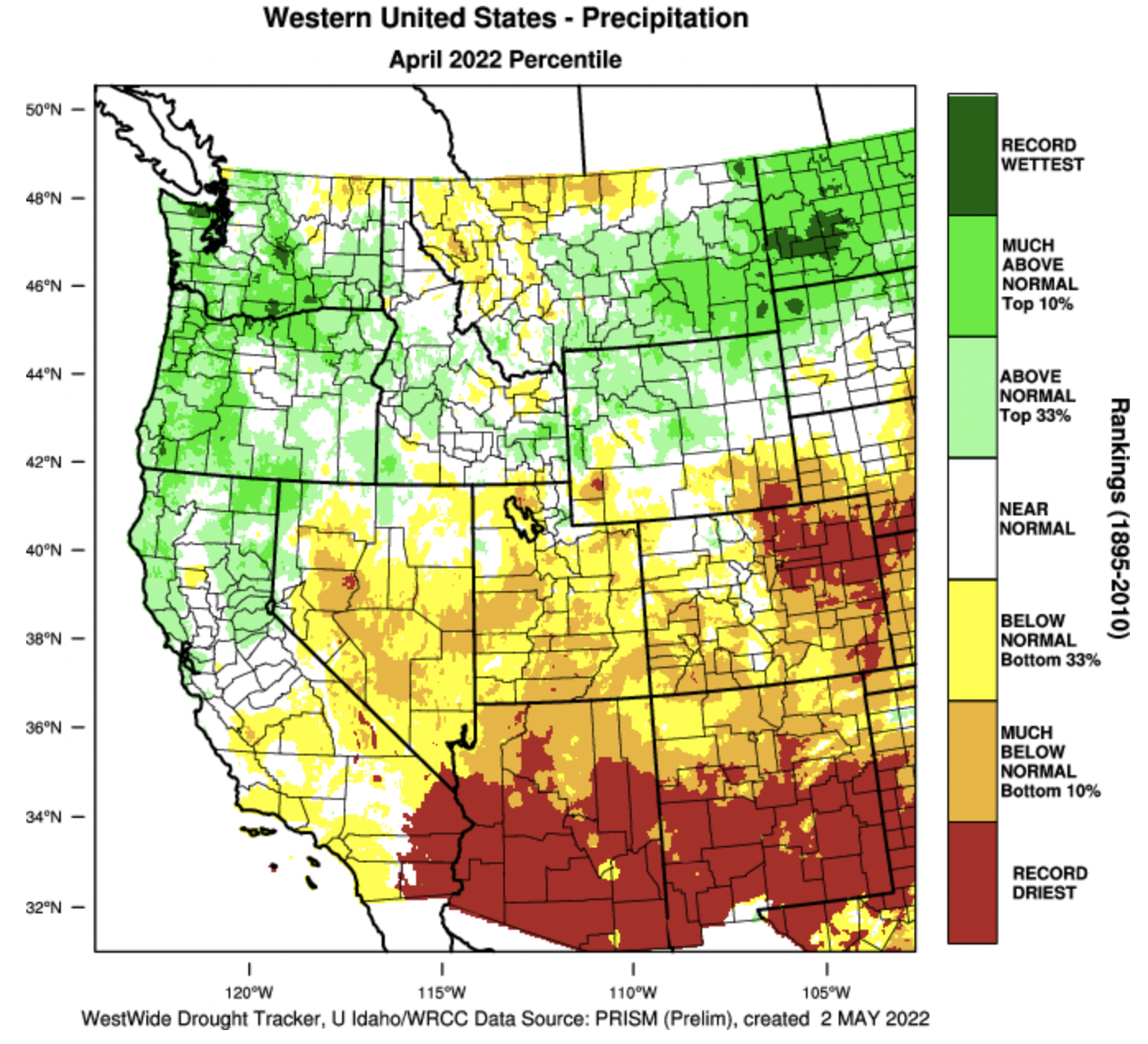
April precipitation was below to much-below normal in Colorado and Utah; precipitation was above average in northern Wyoming and below average in southern Wyoming. Large areas of Utah and southern and eastern Colorado received less than 50% of normal April precipitation. A large swath of the eastern plains of Colorado received less than 5% of normal April precipitation. April precipitation in northern Wyoming was up to 200% of average, but drier in the southern half of the state especially in southeastern Wyoming.

April temperatures were below normal for most of the region with much below temperatures in the north to slightly above normal temperatures in the south. Wyoming experienced the coldest temperatures during April; temperatures were 2 to 6 degrees below normal in most of the state and some locations were up to 8 degrees colder than normal. Temperatures throughout most of Utah and Colorado were within 2 degrees of normal but parts of northern Colorado and Utah were 2 to 4 degrees colder than average.

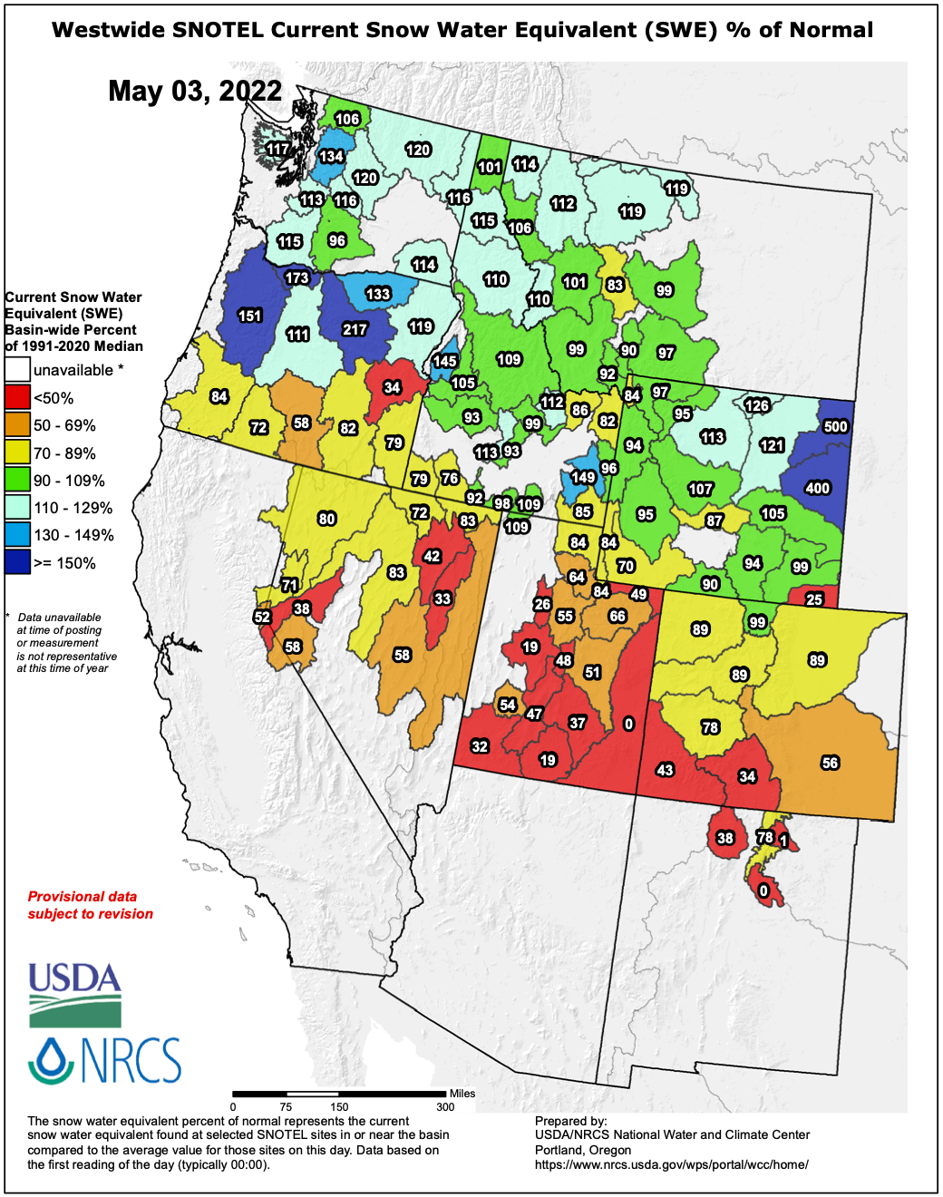
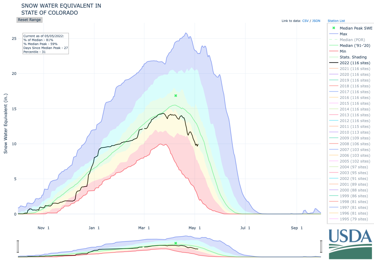
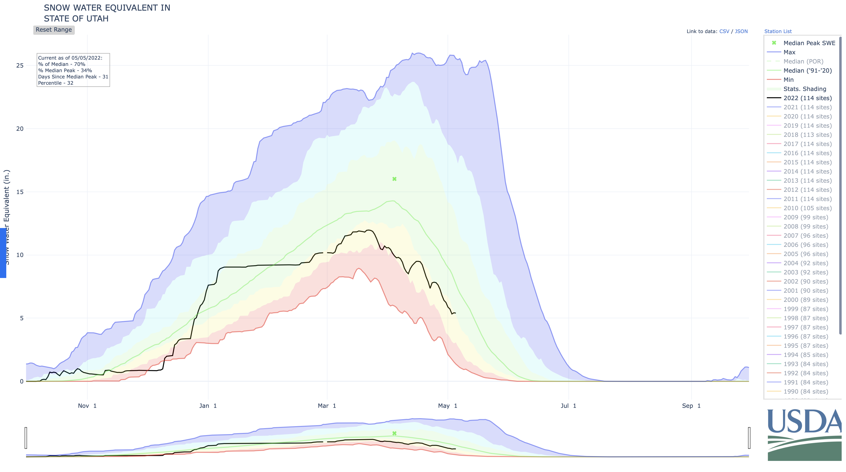
Like April precipitation, snowpack on May 1st was below normal in Colorado and Utah, but near-to-above normal in Wyoming. Except for the Bear River basin, SWE in all Utah river basins was below 70% of normal on May 1st and snow has completely melted from all sites in eastern Utah. Snowpack in northern Colorado was near-to-slightly-below normal and below normal in southern Colorado. Snowpack in most of Wyoming was near-normal on May 1st. Northeastern Wyoming SWE was much-above normal despite being very dry earlier in the winter. Overall, May 1st SWE in the Intermountain West follows patterns that would be expected with La Niña conditions; more snow in the north, less snow in the south. Snowmelt in the San Juan Mountains has occurred at nearly unprecedented rates; snowpack in the Dolores and San Juan River basins was near-normal on April 1st, but fell to 40-50% of normal by May 1st. Four hundred miles to the north in Wyoming, snowpack experienced the opposite change during April. In northern Wyoming river basins, April 1st snowpack was around 70% normal, but April storms increased May 1st snowpack to 100-120% of normal.

Seasonal streamflow volume forecasts in the Upper Colorado River and Great Basins were below to much-below normal. May 1st seasonal streamflow volume forecasts are generally lower in the southern portions of the Upper Colorado River Basin and Great Basins. Streamflow forecasts are relatively higher along the Bear, Mainstem Colorado, Upper Green and Gunnison Rivers. The Surface Water Supply Index (SWSI) is very low in most regional river basins, especially in Utah, due to below normal streamflow forecasts and low reservoir storage. The inflow forecast for Lake Powell on May 1st was 58% of normal, down slightly since April due to low precipitation and rapid melt in the southern portion of the basin during April.
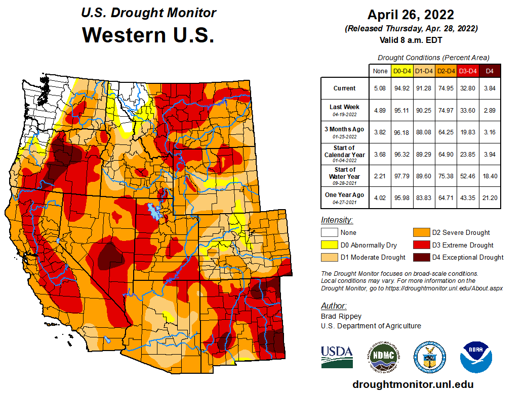
Regional drought conditions change little during April; 94% of the region is in drought and 20% of the region is in extreme (D3) drought. A one category worsening of drought conditions occurred during April in central Utah (D3 drought emerged), southern Colorado (D3) and eastern Colorado (D2). Drought conditions were removed in parts of central Wyoming and a one category improvement of drought conditions occurred in northeastern Wyoming. Drought conditions are expected to persist or develop throughout the remainder of the spring and early summer. Given below average snowpack in many locations and seasonal forecasts suggesting above average temperatures and below average precipitation, drought conditions are likely to worsen.
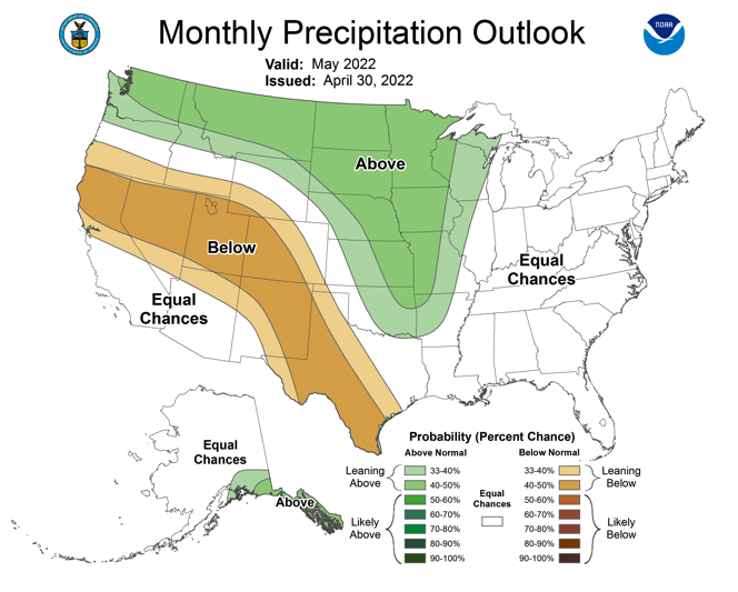
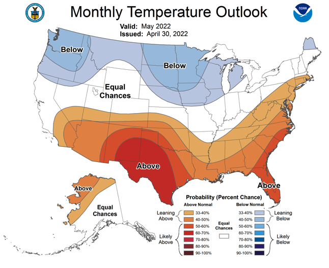
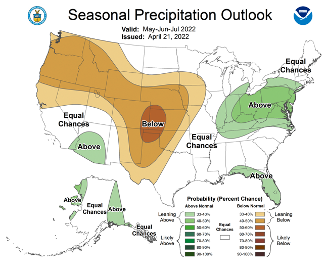
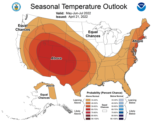
La Niña conditions persisted during April and are forecasted to continue through May. After May, there are nearly equal probabilities of La Niña or neutral ENSO conditions. NOAA precipitation and temperature forecasts for May are consistent with continued La Niña conditions. There is an increased probability of below average precipitation during May for most of Colorado and Utah and an increase probability of above average precipitation in northeastern Wyoming. During May, there is an increased probability of above average temperatures for southern Colorado and southern Utah. The seasonal outlook for May-July looks quite different than May. The entire region is likely to see above average temperatures during May-July with 70-80% probability of above average temperatures in Colorado and Utah. For most of the region, especially Wyoming and Colorado, there is an increased probability of below average precipitation in May-July. In much of Arizona, there is an increased probability of above average precipitation during May-July, suggesting the development of a stronger than average monsoon during June and July. NOAA seasonal forecasts for June-August suggest a further strengthening of the monsoonal pattern during August.
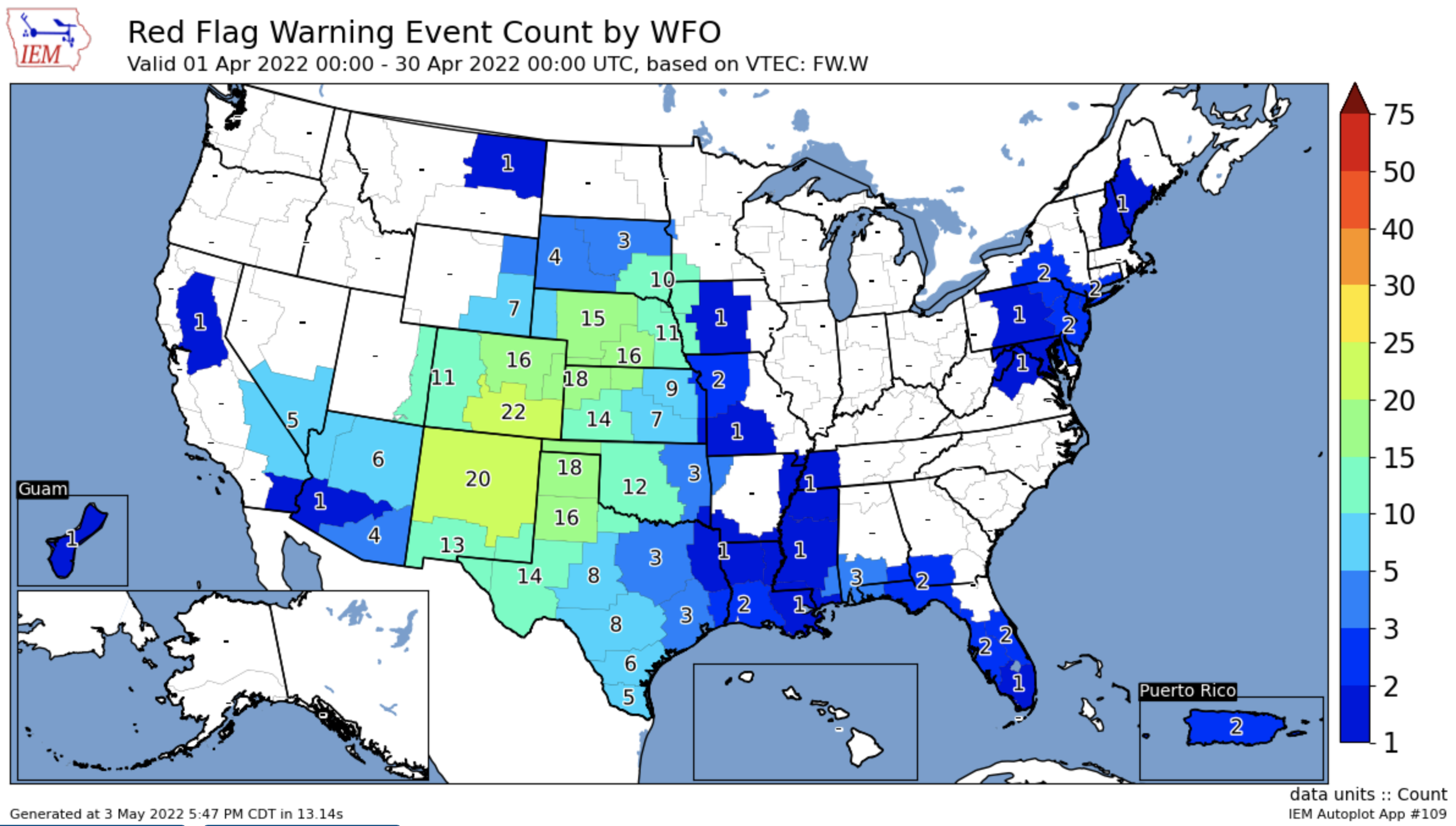
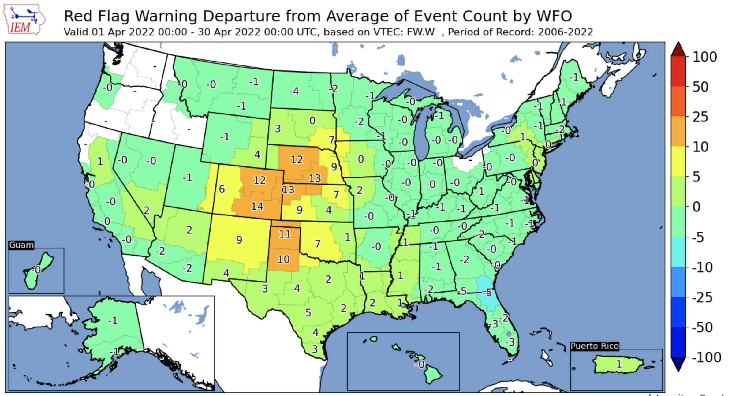
Significant April weather event. Extreme fire weather conditions in Colorado. Colorado, especially along the Front Range and in the Eastern Plains had an unusually high number of days with very high fire danger. The National Weather Service issues Red Flag Warnings when a combination of warm temperatures, low humidity and high winds are forecasted to produce elevated fire danger. In a normal April, 4-8 Red Flag Warnings are issued in Colorado, but this April, Red Flag Warnings were issued 22 times in southeastern Colorado, 16 times in northeastern Colorado and 11 times in western Colorado. The entirety of Colorado east of the Continental Divide is in drought and extreme to exceptional drought emerged in southeastern Colorado during April. April precipitation was extremely low with large areas of the Eastern Plains receiving less than 5% of normal April precipitation. Boulder, Colorado Springs and Limon experienced their driest April on record and large areas of eastern Colorado observed the lowest April precipitation since 1895.