March 8, 2022 (CO, UT, WY)
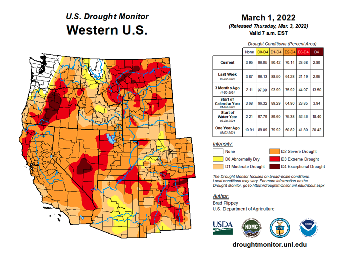
Dry conditions continued across much of the region during February and regional snowpack generally declined relative to normal despite below average temperatures. March 1st seasonal streamflow volume forecasts also declined compared to February 1st forecasts. Streamflow forecasts generally range from below normal to slightly above normal throughout the region and the inflow to Lake Powell is forecasted to be 72% of median. Drought persists across 97% of the region and extreme drought developed in northwestern Wyoming. Current La Niña conditions and NOAA seasonal forecasts suggests that significant alleviation of drought conditions will not occur during the remainder of winter.
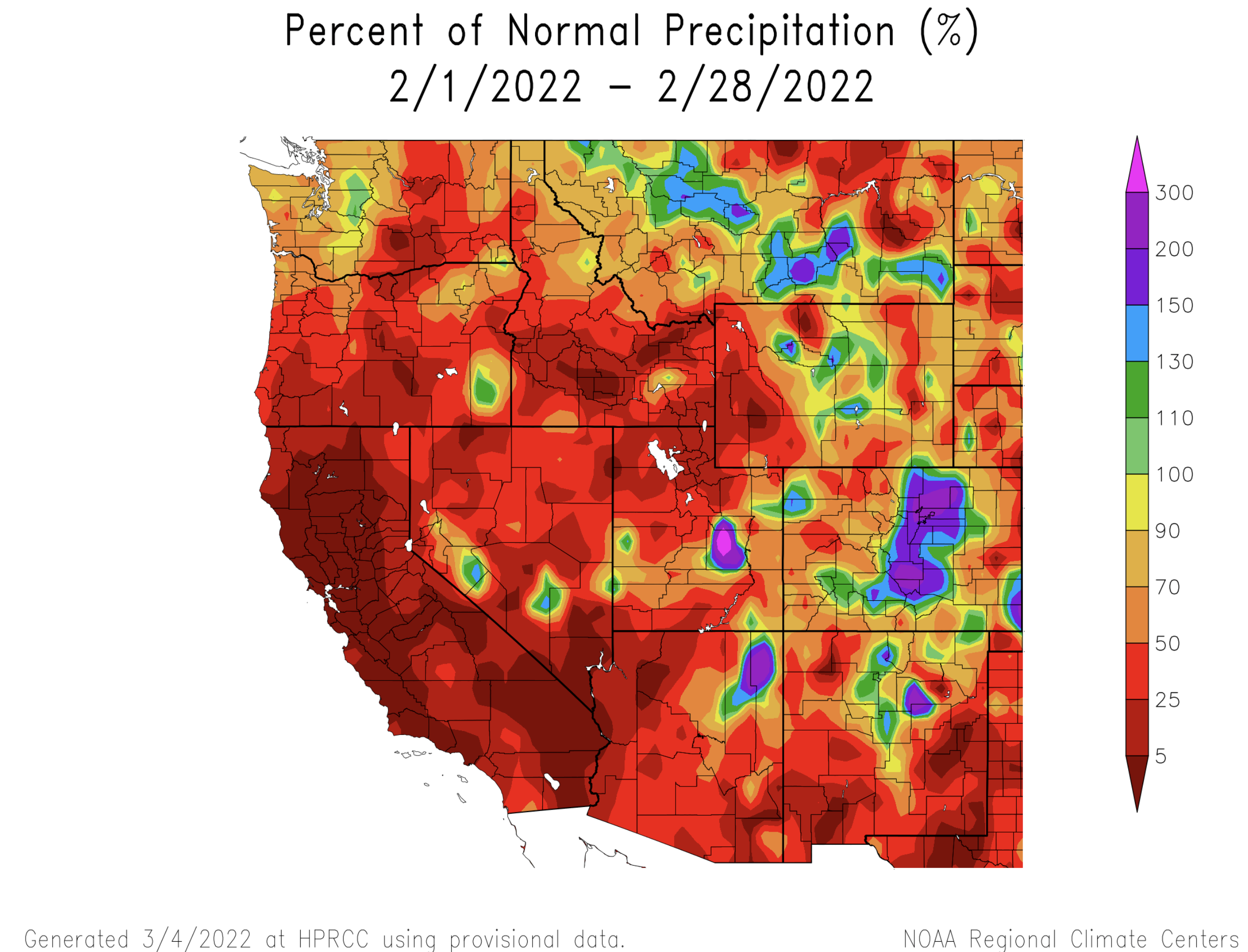
February precipitation was below to much-below normal for most of the region. Large portions of Utah and western Wyoming received less than 50% of normal precipitation. Western Colorado, southern Wyoming and eastern Wyoming generally received 50-90% of normal February precipitation. Precipitation was slightly above normal in central Wyoming and up to 300% of normal in eastern Colorado.
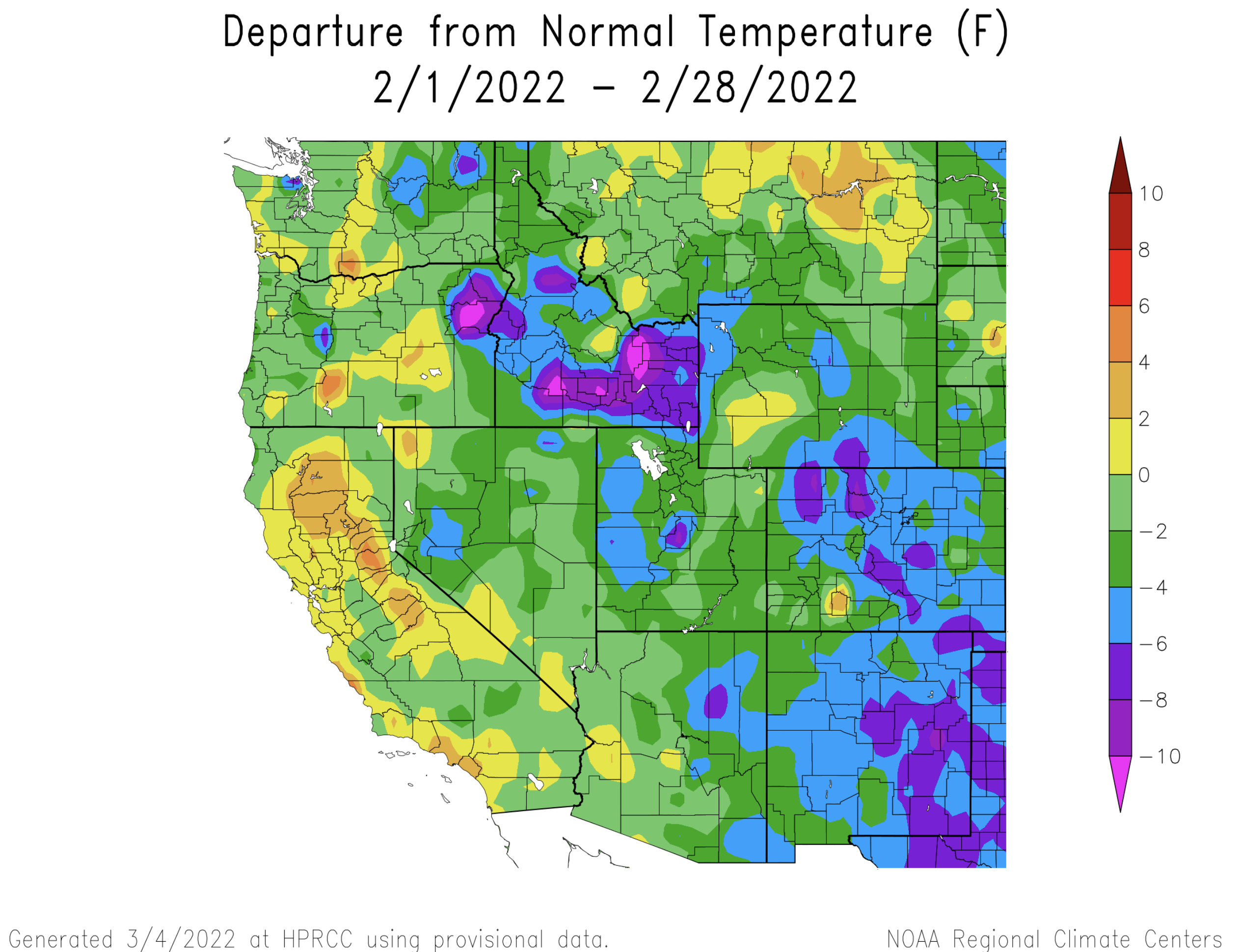
Temperatures were below average during February in Colorado, Utah and Wyoming. In most of Utah and Wyoming, February temperatures were 2-4 degrees below normal and central to eastern Colorado saw temperatures that were 4-8 degrees below normal.
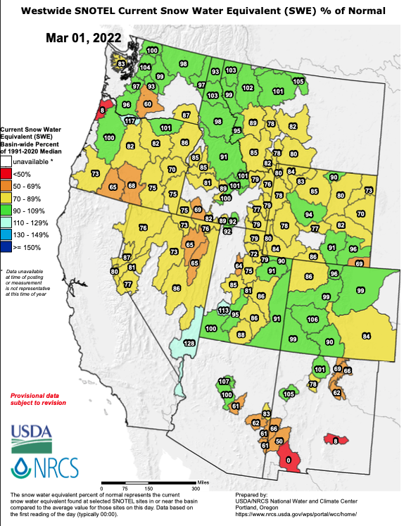
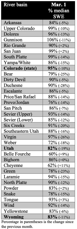
Regional snowpack continued to decline relative to normal and ranges from 62% to 106% of normal in regional river basins. Snowpack is deepest in Colorado with 95% of normal statewide snowpack. Statewide snowpack is at 82% of normal in Utah and 83% of normal in Wyoming. The largest declines in snowpack relative to normal during February were in northern Utah and western Wyoming.
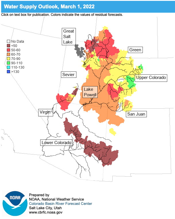
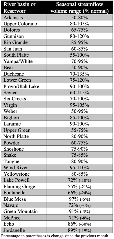
March 1st seasonal streamflow volume forecasts range from much-below normal to normal across the region and decreased since February 1st for all regional river basins except the San Juan and Rio Grande Rivers which remained unchanged. Streamflow forecasts generally range from 55-135% of normal in the Upper Colorado River Basin, 50-11% of normal in the Great Basin and 50-110% of normal in Colorado and Wyoming east of the Continental Divide. The lowest March 1st seasonal streamflow forecasts were in the Bear, Dolores, Upper Green, Powder and Weber River Basins. The greatest decreases in season streamflow forecasts since February 1st were found in the Bear, Upper Green, Sevier, Six Creeks and Weber River Basins, roughly correlating to where February precipitation was lowest.
Drought conditions expanded slightly during February and now cover 97% of the region; extreme (D3) drought conditions continue to cover 18% of the region, but shifted in location. In Colorado, D3 drought was removed from the Eastern Plains and decreased in coverage in the Rio Grande River Basin. In Utah, drought remained unchanged except for a small area of improvement in southwestern Utah. In Wyoming, D3 conditions expanded in northeastern Wyoming and developed in the Teton and Wind River Ranges. Significant regional improvement in drought regional drought conditions seems unlikely during the remainder of winter.
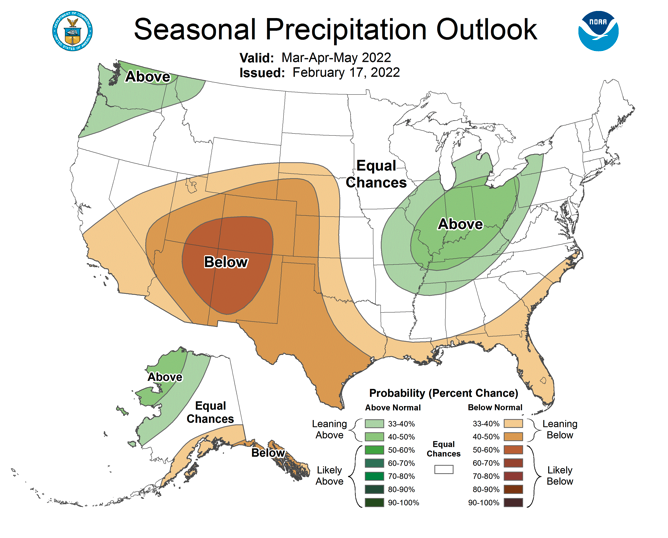
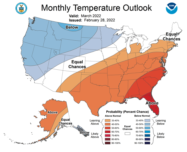
A La Niña advisory remained in effect during February and Pacific Ocean temperatures are currently 0.5-1ºC below normal. Weak La Niña conditions are projected to remain in place through March-May, but ENSO neutral conditions are likely to return by May-July. NOAA seasonal forecasts for March suggest an equal probability of below or above average precipitation for the region and an increased probability of below average temperatures for Wyoming and most of Utah. On the three-month timescale, NOAA seasonal forecasts predict an increased probability of below average precipitation, especially for the Four Corners region, and an increased probability of above average temperatures for the entire region except northern Wyoming.

Significant February weather event: Wyoming cold wave. On February 22-23, an extremely cold air mass dropped into the Northern Rockies east of the Continental Divide, causing a short-lived but intense period of cold temperatures across Wyoming and northeastern Colorado. A cold front arrived on 2/21 causing record low minimum and maximum temperatures on 2/22-2/23. Temperatures bottomed out at -34ºF at Lamar Ranger Station in Yellowstone National Park on the morning of 2/23. Considering weather stations with at least 50 years of data (there are 77 such stations in Wyoming), 16 record low temperatures were set on 2/22 and 21 records set on 2/23. Even more record low maximum temperatures were set with this cold wave. Record low maximum temperatures were set at 44 sites on 2/22 and 52 records were set on 2/23. While the cold wave was not as extensive in Colorado, many record low temperature records along the Front Range were also broken, including in Fort Collins, Boulder, Denver, Colorado Springs and Pueblo.
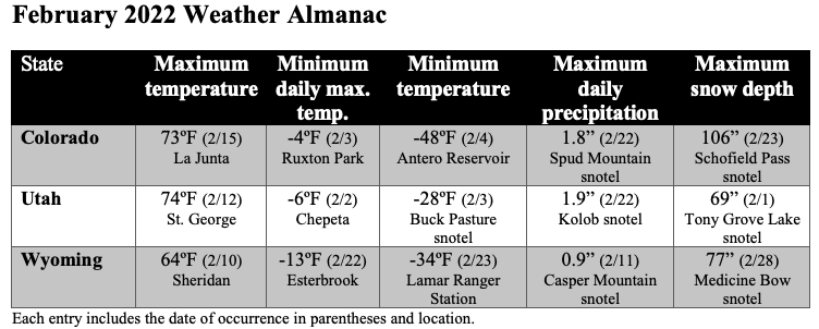
This month’s climate summary includes a monthly weather almanac which highlights climate extremes for the month of February in each state. This will be a regular addition to future monthly climate summaries.