January 7, 2022 (CO, UT, WY)
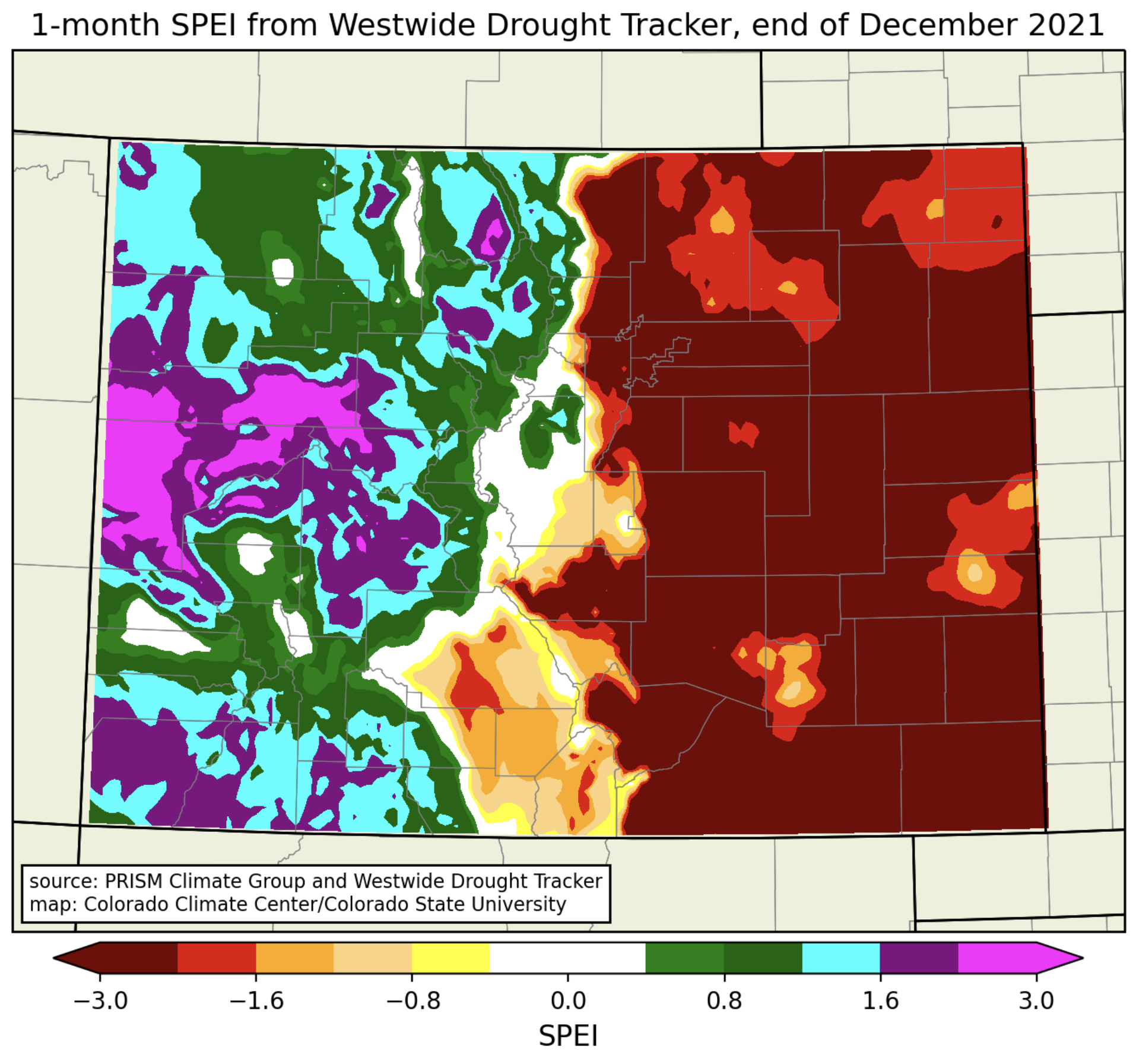
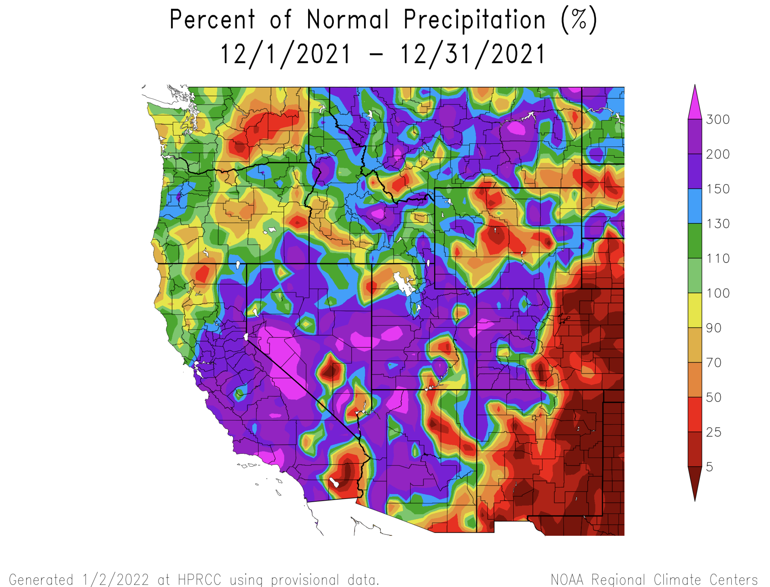
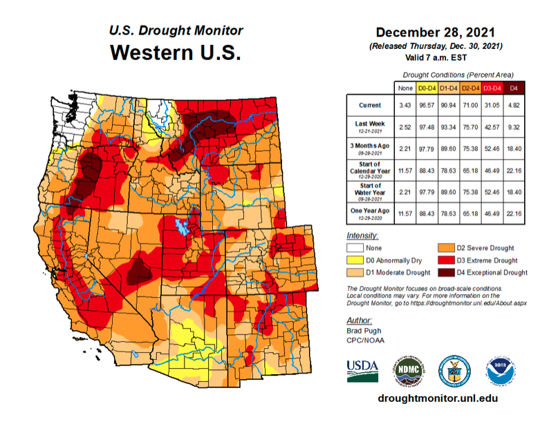
Precipitation was much above normal during December except for Colorado east of the Continental Divide and parts of northern and eastern Wyoming. December began with much below normal regional snowpack, but a very stormy last three weeks of the month left nearly all river basins with normal to much-above normal snowpack. January 1st seasonal streamflow volume forecasts were near- to above normal for the Upper Colorado River and Great Basins. Drought conditions remain in place in 98% of the region, but prolific December precipitation eased drought in many locations except east of the Continental Divide in Colorado where drought conditions worsened. Extreme drought conditions and very strong downslope winds contributed to the catastrophic Marshall Fire in Boulder County on December 30th which burned more structures than any other in Colorado history.
Precipitation was much above normal during December for most of Utah, western Colorado and parts of Wyoming. The first half of December was relatively dry, but 10-day storm cycle beginning before Christmas left December precipitation between 150% to over 300% of normal in Utah (except northwestern and southeastern), western Colorado and part of Wyoming. Much of the regional precipitation during December was derived from atmospheric river events; these storms stayed west of the Continental Divide in Colorado which led to much below normal precipitation for eastern Colorado and southeastern and central Wyoming.
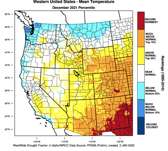
December temperatures were above normal for the entire region with all areas experiencing temperatures that were at least 2-4 degrees above average. Temperatures were 6-10 degrees above average in eastern Colorado and large parts of Wyoming. Western Colorado temperatures were generally 4-6 degrees above average and much of Utah experienced temperatures that were 2-4 degrees above average. Temperatures in most of Colorado and southern Wyoming were among the warmest 11 years since 1895 and an area along the Arkansas River around Pueblo experienced its warmest December on record.

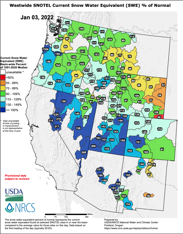
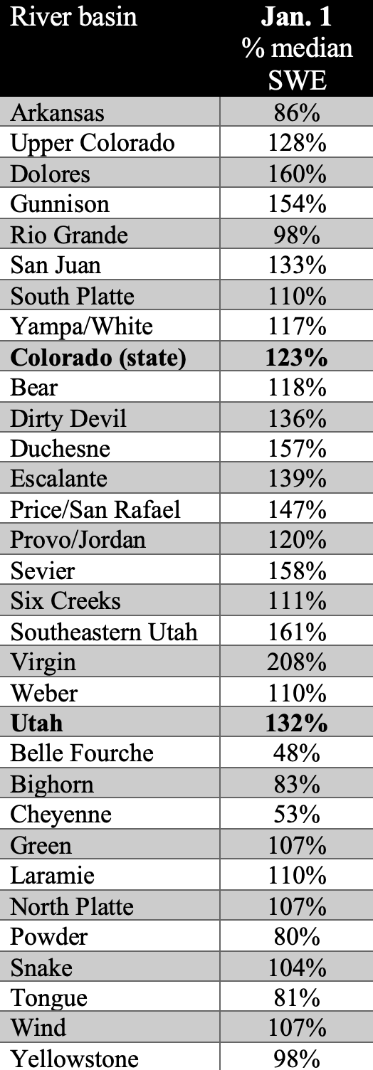
The 2022 water year has been one of wild monthly swings in snow-water equivalent. A very stormy and cool October left most of the region with above to much-above normal snowpack on November 1st. A dry and warm November left the entire region, especially Utah, with much below normal snowpack on December 1st. As of January 3rd, SWE is near- to above normal for the entire region except northeastern and southeastern Wyoming. All river basins in Utah have above normal SWE, ranging from 108% of normal in the Weber River Basin to 208% of normal in the Virgin River Basin. In Colorado, SWE ranges from 91% of normal in the Arkansas River Basin to 151% of normal in the Gunnison River Basin. Wyoming snowpack is near-normal to slightly above normal in western and southern parts of the state, but is below normal in much of northern and eastern Wyoming. Thus far, the 2022 water year is not behaving like a typical La Niña year. La Niña typically favors the northern part of the region with above average precipitation and the southern portion of the region with below normal precipitation. So far, the opposite is observed with more snow in the southern areas and relatively less in northern areas.
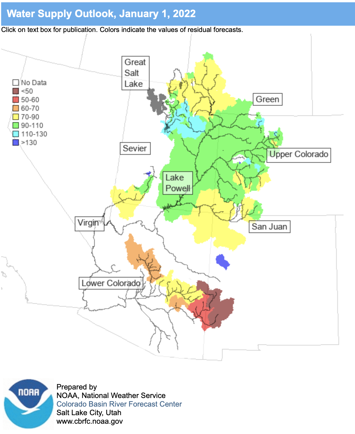
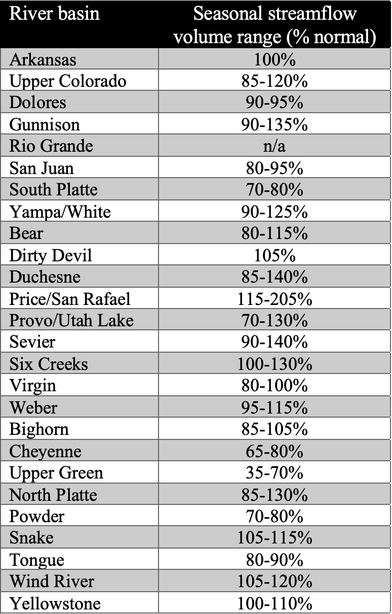
Much above average precipitation in the last three weeks of December resulted in near- to above normal seasonal runoff forecasts in the Upper Colorado and Great Basins as of early January 2022. Colorado Basin River Forecast Center seasonal runoff forecasts for the Upper Colorado River and Great Basins range from 70 – 140% of normal. For the first time since 2019, many river basins have near to above normal forecasts for seasonal runoff volumes. The forecasted inflows for major reservoirs include Fontanelle 650 KAF (thousand acre-feet) (88% average), Flaming Gorge 840 KAF (87%), Green Mountain 265 KAF (95%), Blue Mesa 650 KAF (102%), McPhee 235 KAF (92%), Navajo 550 KAF (87%), Deer Creek 141 KAF (119%), Strawberry 60 KAF (100%), Echo 174 KAF (116%), Pineview 123 KAF (93%) and Lake Powell 6.3 million acre-feet (99%).
The good news about drought during December is that D4 drought was completely removed from the region; the bad news about drought last month is that it still covers nearly 98.9% of the region. In Colorado, drought conditions improved by 1 category on parts of the West Slope. East of the Continental Divide, drought conditions worsened by 1 category in many locations and severe or extreme drought covers the entire eastern plains of the state. Exceptional (D4) drought was entirely removed from Utah and parts of central Utah saw a two-category improvement to drought conditions. Drought conditions did not change in Wyoming during December.
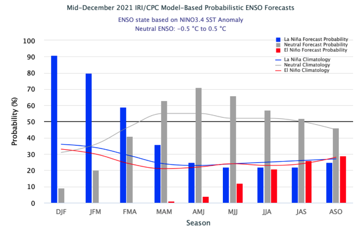
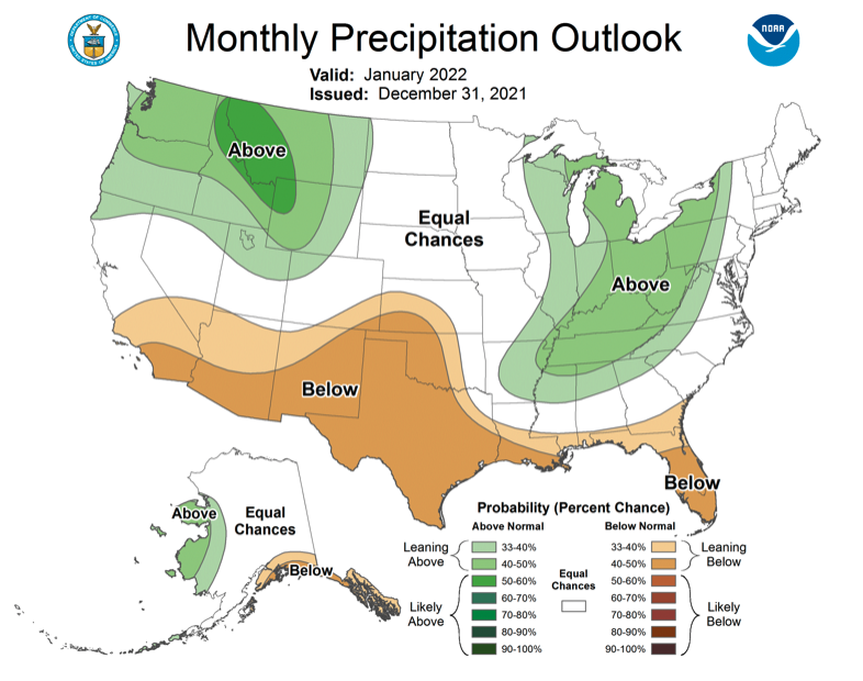
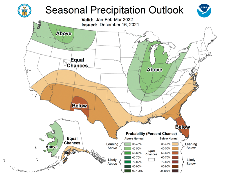
La Niña conditions continued during December and there is an 80% probability that the current La Niña will continue through March. By May, there is a 60% probability that ENSO neutral conditions will occur. The persistence of La Niña conditions through winter is reflected in the NOAA precipitation and temperature forecasts for January and January – March with cooler wetter conditions predicted in the northern portion of the region and warmer, drier conditions in the southern part of the region. Most notably, the NOAA forecast for January predicts an increased probability for above average precipitation in most of Wyoming and northern Utah. There is an elevated probability for above average January temperatures in eastern Utah and Colorado.

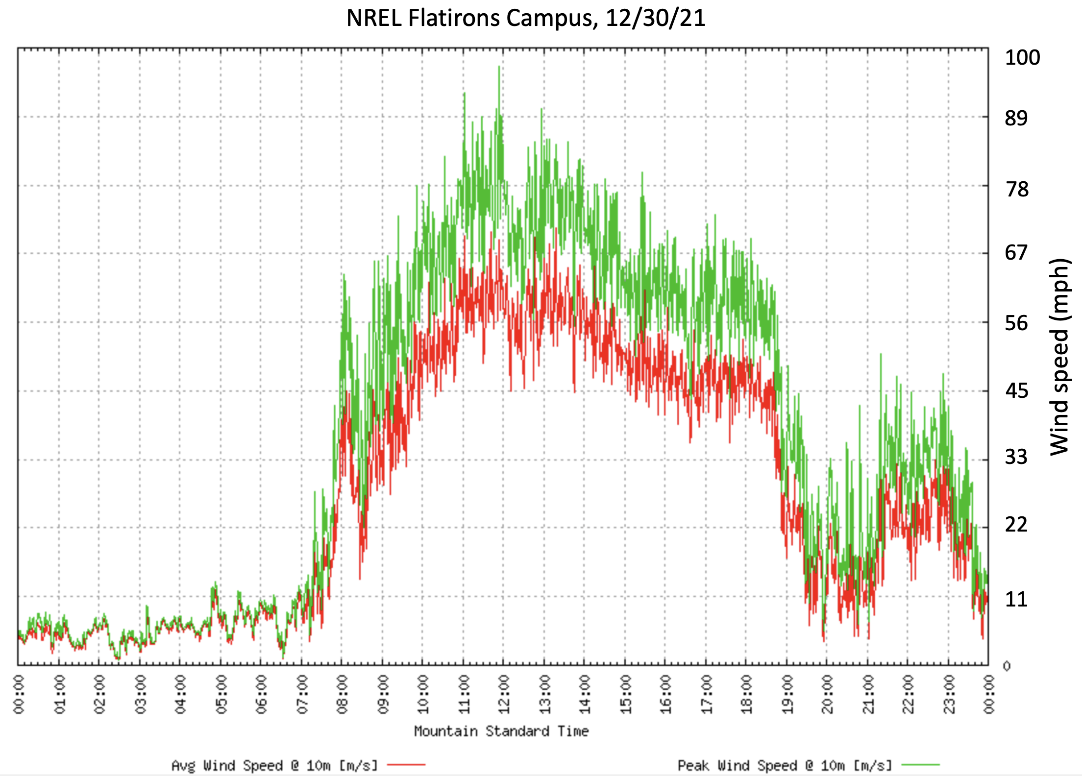
Significant December weather event. In the late morning on December 30th, the Marshall Fire ignited near the base of the foothills in Boulder County, Colorado. The fire started around 11:30 am in the midst of a significant downslope or Chinook wind event. Fire spread eastward across tinder-dry grasslands, fanned by wind gusts from the west of over 100 mph. Throughout the remainder of 12/30 and early on 12/31, the Marshall Fire burned, growing to 6,200 acre, destroying 1084 residential structures in the towns of Superior and Louisville and likely causing 2 fatalities. The Marshall Fire was not the typical Colorado wildfire; it began in an unfrosted, rural part of the county, burned rapidly through grassland, and then turned into an urban/suburban fire burning homes and businesses first in Superior, then Louisville, after the fire jumped four lanes of Highway 36. Although the source of the fire remains under investigation, the Marshall Fire was human-caused; the speed and ferocity of the fire was driven by multiple, coincident hazards. First, a very wet late winter and early spring in Boulder caused prolific plant growth in foothills grasslands. Second, August through December 2021 was one of the warmest and driest on record in Boulder so that by December, Boulder County was in extreme drought. Thirdly, an extreme downslope wind event occurred on the morning of December 30th which caused rapid spread of the fire. Dry conditions during summer and fall, especially during December, caused the extensive grassland vegetation to dry and extreme downslope winds caused the fire to spread with great speed once it started. As with many other singular events, climate change did not cause the Marshall Fire, but drought conditions, exacerbated by climate change, set the stage for the catastrophic fire. Finally, the fire occurred during a time with Covid cases spiking, adding yet another layer of complexity towards recovery. The cause of the fire remains under investigation. Check WWA’s website in the coming weeks for a detailed analysis of climate factors and multiple hazards involved in the Marshall Fire. For ways to assist Boulder County residents displaced from the fire, visit resources available here.