February 9, 2024 - CO, UT, WY
After a relatively wet January, snowpack conditions improved and are near-average in Utah (96%), slightly-below average in Colorado (87%) and below average in Wyoming (74%). Seasonal streamflow volume forecasts are below average for most locations except for northern Utah where forecasts predict average to slightly-above average seasonal streamflow. Regional coverage of drought remained steady at 15% and alleviation of some drought conditions in southwestern Colorado was offset by the development of drought in northern Wyoming. El Niño conditions are expected to continue through spring with above average precipitation and temperatures predicted for February.
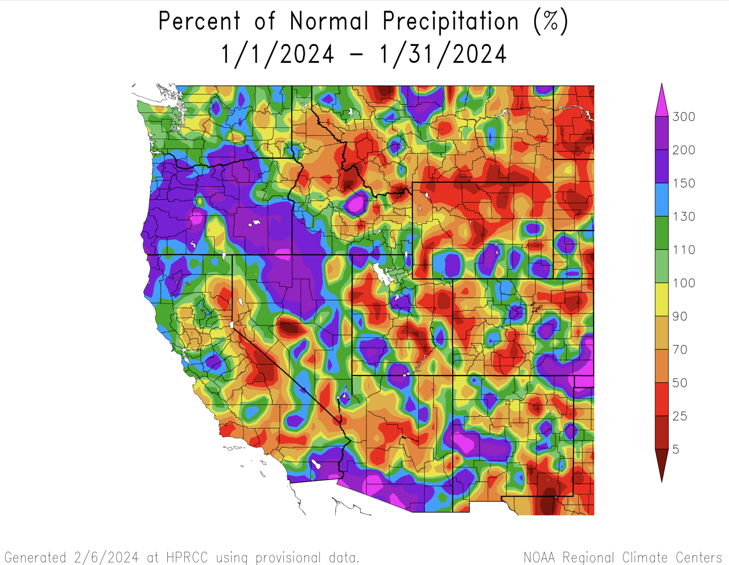
Across the region, a patchwork of above and below average precipitation fell during January. Slightly-above average January precipitation was observed in northern Colorado, southern Wyoming and along the Wasatch Front and southwestern Utah. Much-above average January precipitation was observed in southeastern Colorado. Below average January precipitation, including large areas of less than 50% of average, fell in northeastern, south-central and northwestern Colorado and Utah and across all of northern Wyoming.
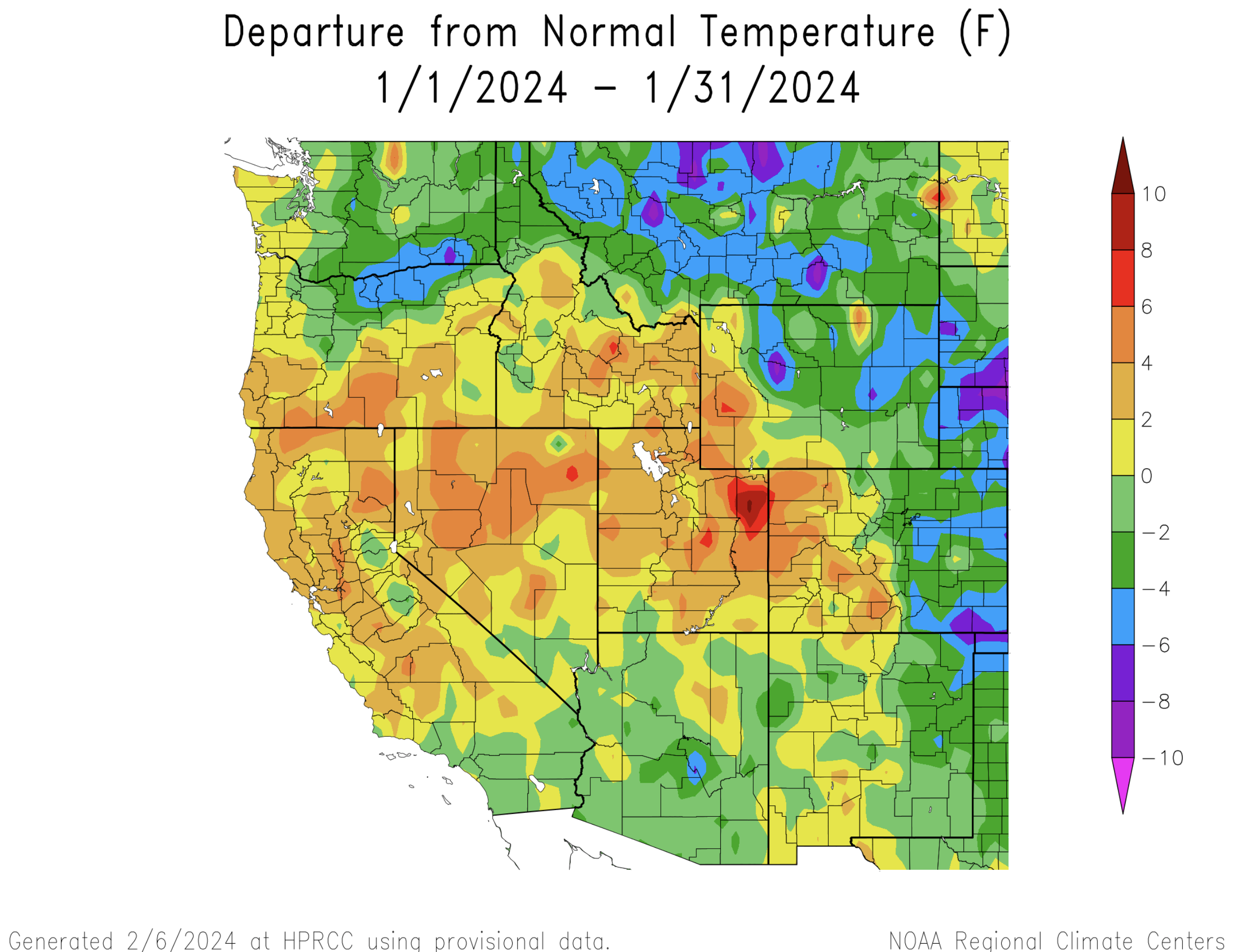
January temperatures were generally above average in the southwestern portion of the region and below average in the northeast. In Colorado and Wyoming, January temperatures were above average on the west side of the Continental Divide and below average east of the Divide with temperatures as cold as 10 degrees below average. Utah temperatures were generally 2 to 4 degrees above average but the eastern Uinta Basin saw temperatures up to 10 degrees warmer than average.
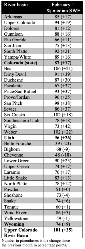
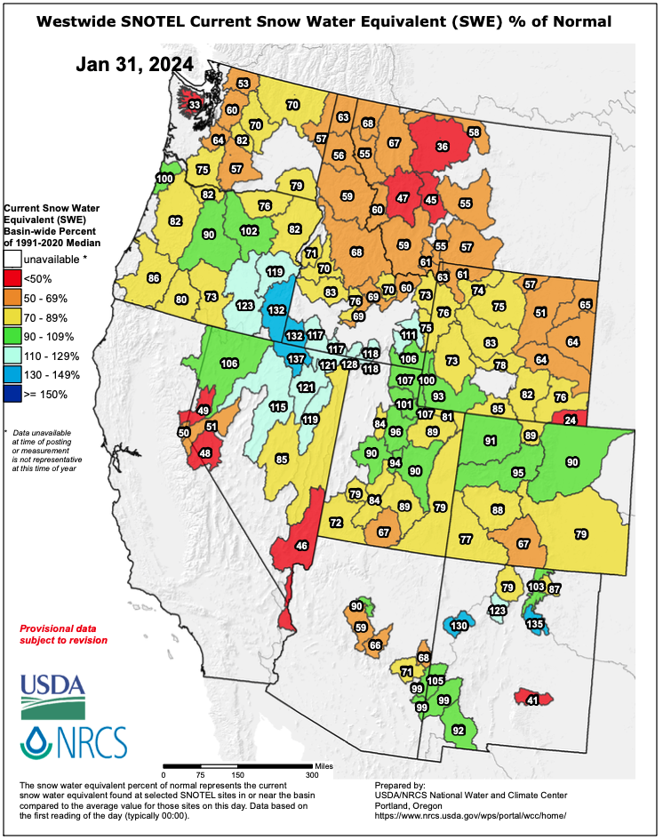
Regional snowpack at the end of January was a mix of near-normal and below normal conditions. Near-average snow water equivalent (SWE) was observed in northern Utah and northern Colorado. In southern Colorado, southern Utah and much of Wyoming, SWE was 70-90% of average. Snowpack in northeastern Wyoming and in the Yellowstone River Basin was much-below normal (50-70% average). Statewide SWE improved relative to average in Colorado (87%), Utah (96%) and Wyoming (74%).
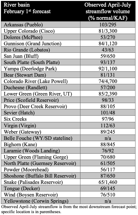
Regional April-July streamflow volume forecasts are generally below to much-below average, except northern Utah where streamflow forecasts are near to above average. In most locations, forecasted streamflow volume increased compared to the January 1st forecast. Streamflow forecasts are lowest for the Dolores, Duchesne and San Juan River Basins. The forecast for the inflow to Lake Powell is 74% of average.
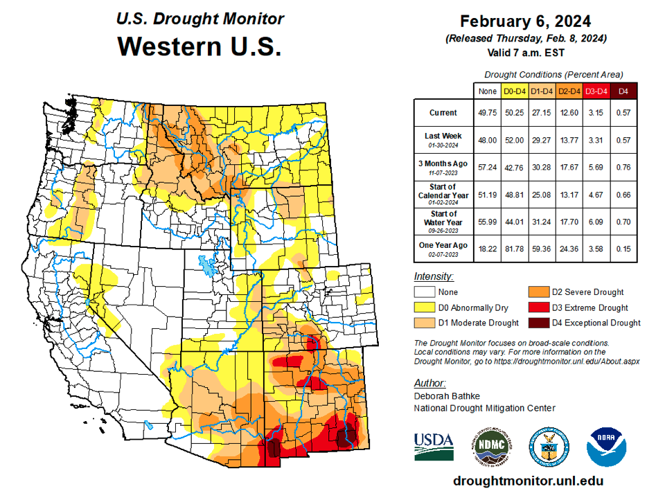
Total regional coverage of drought remains at 15% and unchanged since December. Drought development in northern Wyoming was balanced by drought improvement in southeastern Utah and southwestern Colorado.
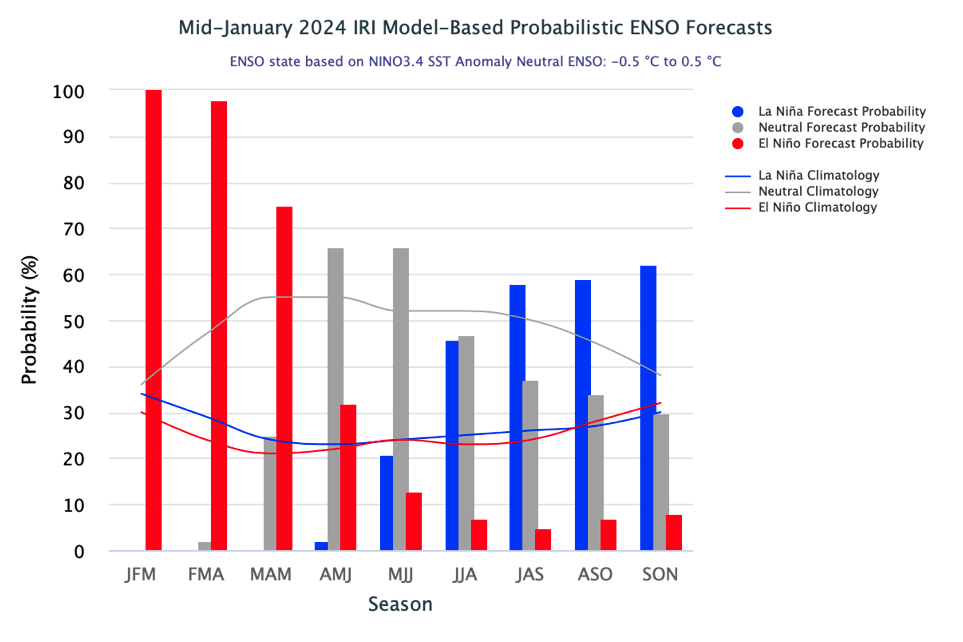
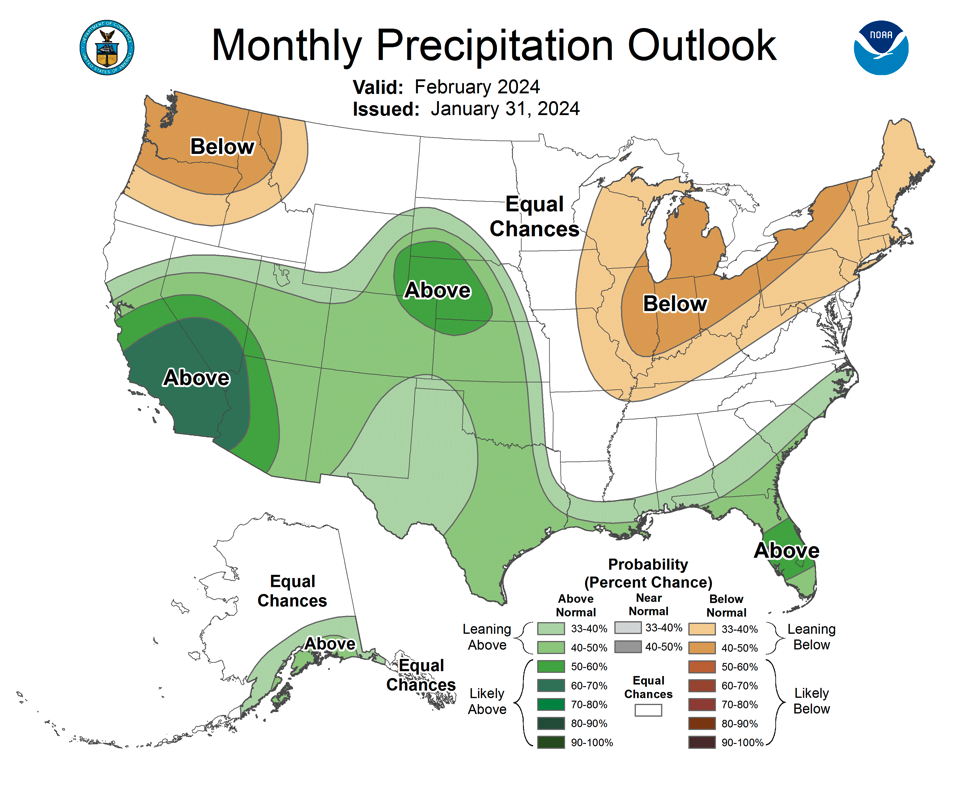
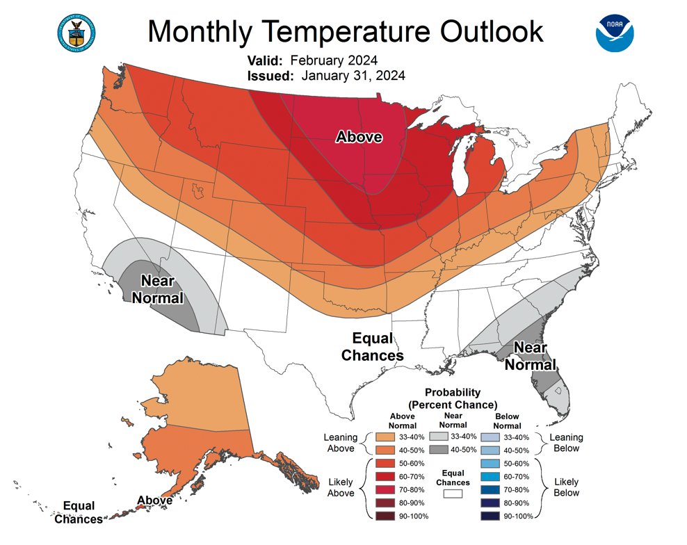
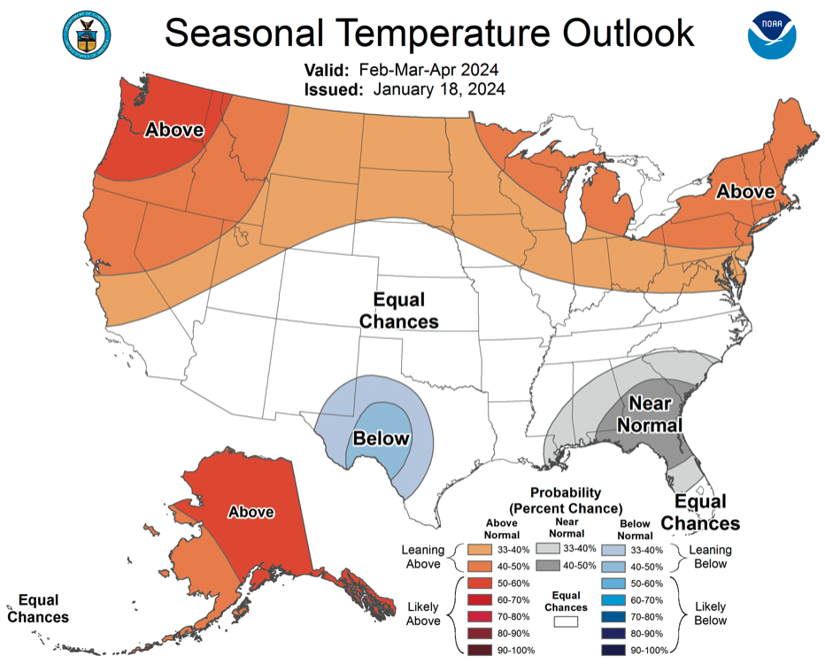
El Niño conditions continue as ocean temperatures in the eastern Pacific were 1.5–2 degrees Celsius above average. All ocean temperature models are projecting a steady cooling of ocean temperatures and there is a 70% chance of El Niño conditions continuing through spring (March-May). This summer, there is a 65% probability of neutral ENSO conditions but by fall, there is a 60% chance of La Niña conditions developing. The NOAA monthly outlook for February suggests an increased probability of above average precipitation for Colorado, Utah and eastern Wyoming and above average temperatures for the entire region. During February–April, the NOAA seasonal forecast suggests an increased probability of above average temperatures for northern Utah and Wyoming.
January significant weather event: Early January storm cycles and avalanches. After a stormy early December in the West, very dry conditions prevailed across Colorado, Utah and Wyoming from December 10–January 4. Beginning on January 4 and lasting for 11 days, near-continuous storms impacted the Intermountain West and brought below and much-below average snowpacks to near-normal by January 15. River basins reached near-normal SWE conditions by January 15 including the Bear, Jordan, Yampa-White and Weber which received 3.5–5.5” of SWE. A few snotel sites in northern Utah received very high amounts of SWE from January 4–January 15 including 10.4” at Ben Lomond Peak near Ogden, 8.5” at Alta near Salt Lake City and 8.3” at Tony Grove Lake near Logan. With the combination of a month-long snow drought and the rapid addition of SWE to mountain snowpacks in Utah, extreme avalanche danger was forecasted for the entire Wasatch Mountain Range from Logan to Provo including the Wasatch Plateau in central Utah. It was extremely rare to see extreme avalanche danger over the entire Wasatch Mountain Range on a single day and not something that I have personally observed over the last 17 years. Extreme avalanche danger closed Little Cottonwood Canyon Road for 36 hours and avalanche mitigation efforts triggered numerous full-path avalanches that buried the road.