February 9, 2023 - CO, UT, WY
The calendar year started with near-continuous storms and favorable water supply forecasts. Snow-water equivalent (SWE) was near-normal to much-above normal for most of the region, with February 1st SWE as high as 200% of normal in Utah and southwestern Wyoming and 150% of normal in Colorado and the rest of Wyoming. Regional precipitation was generally greater than 200% of normal. Regional temperatures were mostly near normal, with pockets of below normal temperatures in Colorado and Wyoming. February 1st seasonal streamflow forecasts are near-to-much-above average except for the river basins east of the Continental Divide in Colorado. Regional drought conditions improved slightly during January. Neutral ENSO conditions are likely to prevail by early spring.
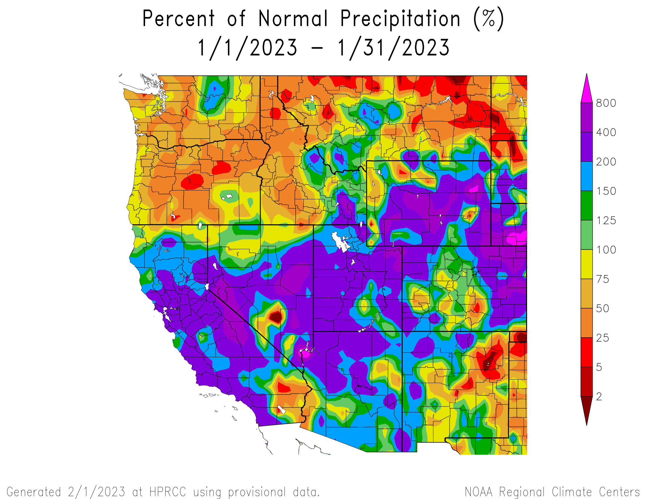
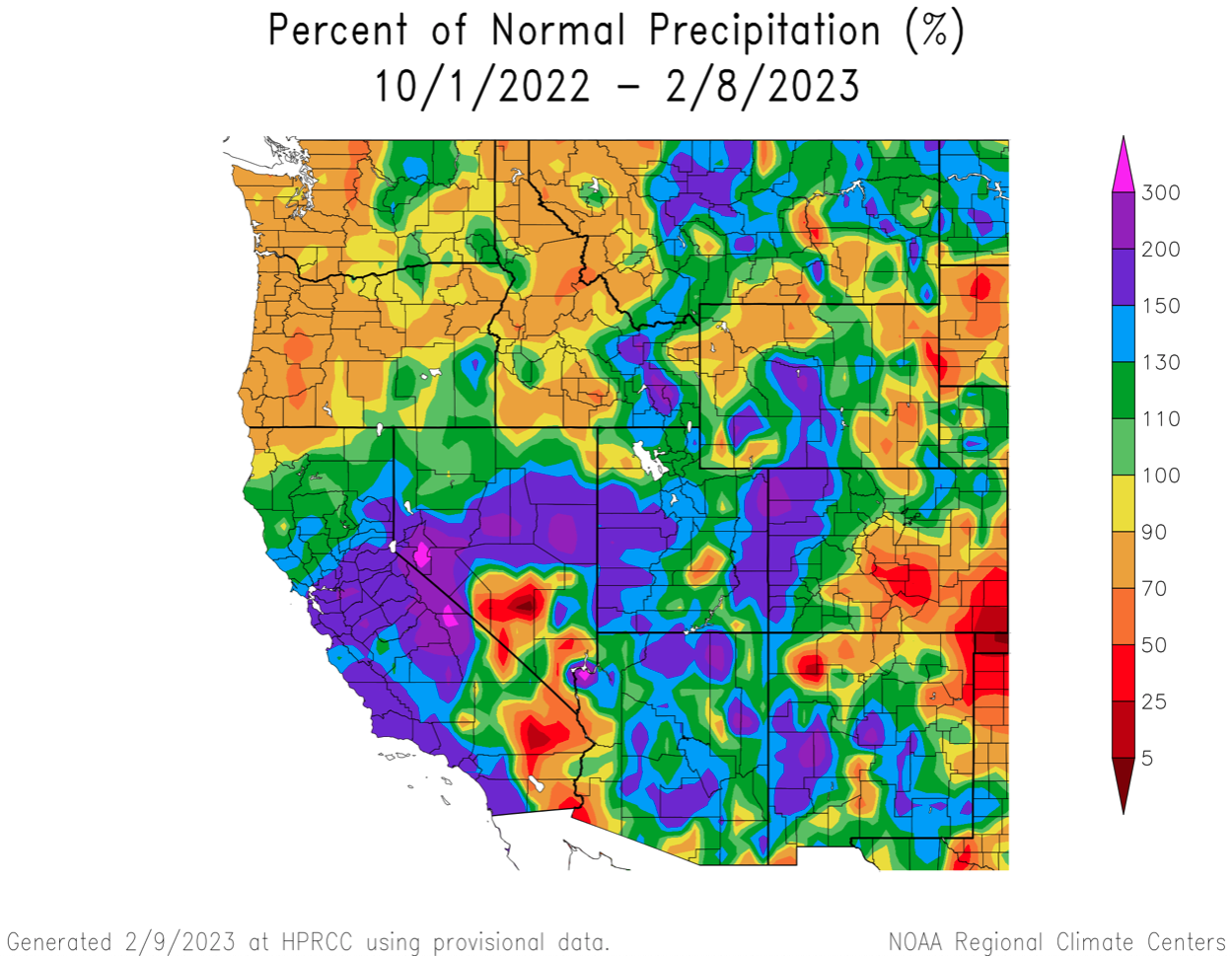
January precipitation was greater than 200% of normal for much of the region, particularly in Utah. Parts of central Wyoming and northeastern Colorado received over 400% of average precipitation in January. Pockets of below normal January precipitation were observed in central Colorado and northwestern Wyoming. Regional water year precipitation is average to above average except in southeastern Colorado northwestern Wyoming and eastern Wyoming.
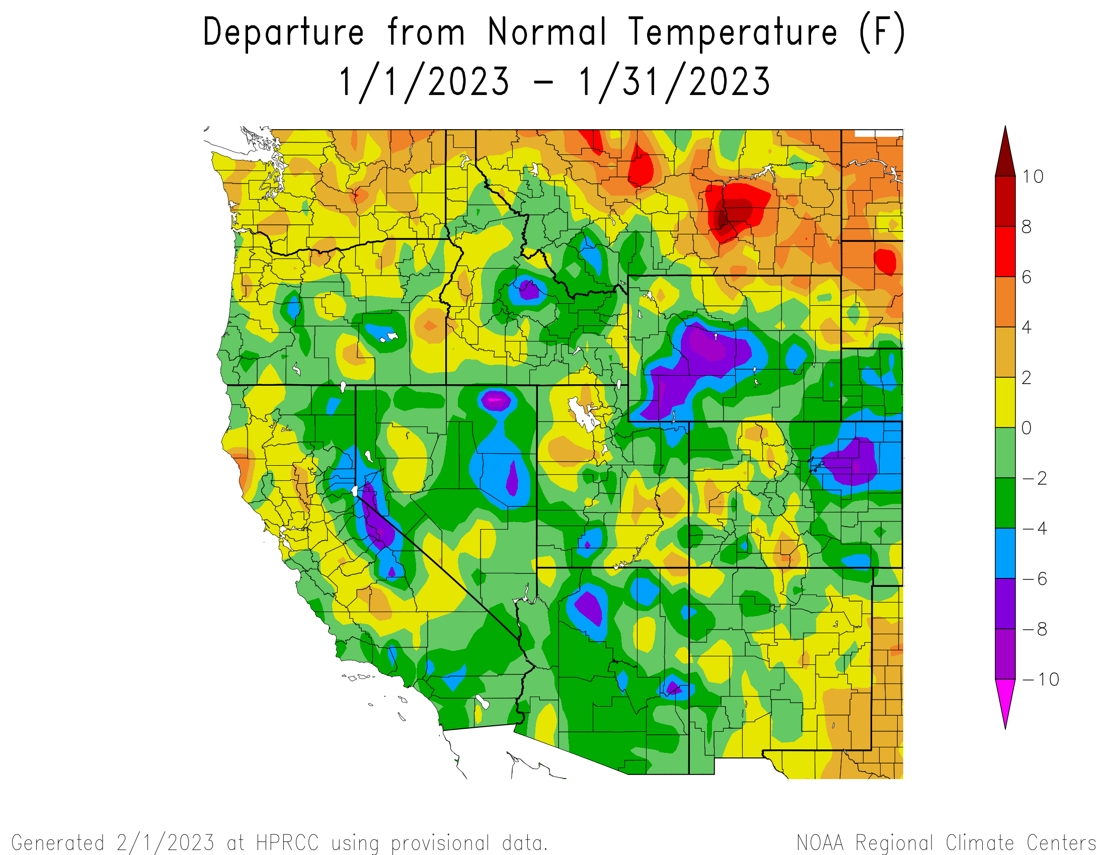
Regional temperatures were mostly near-normal to below normal in January. Parts of central Wyoming were up to 8 degrees below normal. Locations with warmer than normal January temperatures included the Great Salt Lake basin, eastern Utah, central Colorado, and northeastern Wyoming.
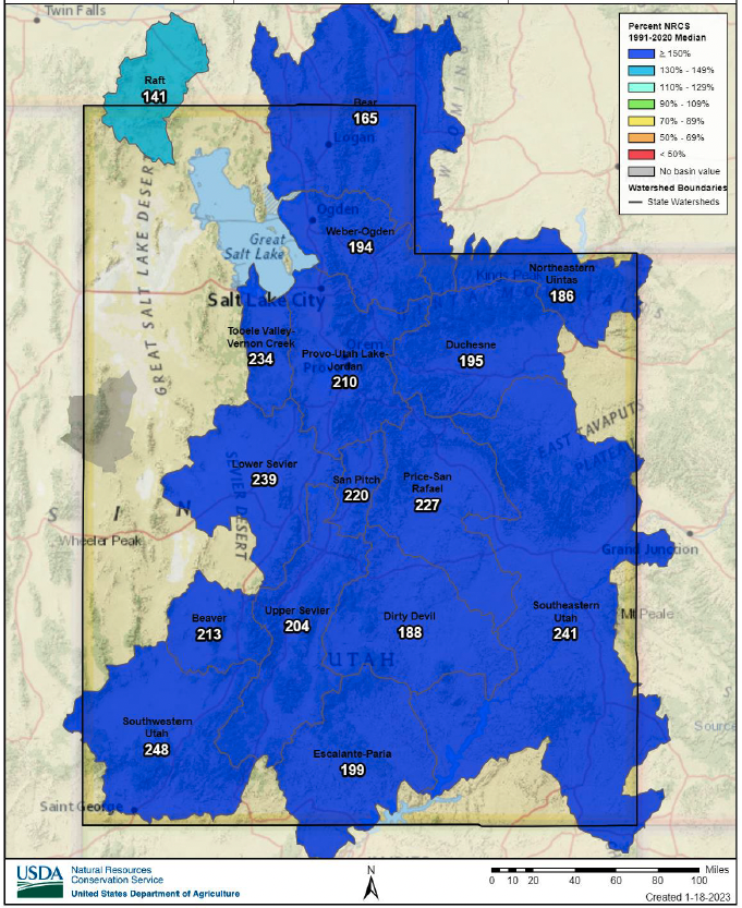
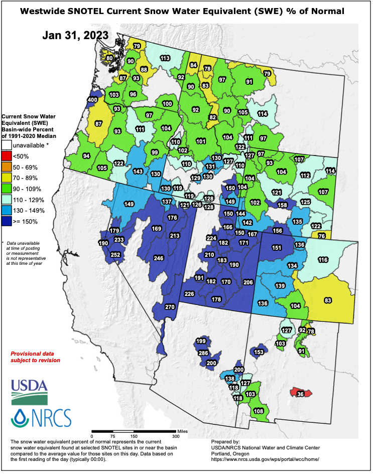
Regional snow water equivalent (SWE) is near-normal to much-above normal for the entire region except for the lower Arkansas River Basin. February 1st SWE is 140-200% of normal in Utah and southwestern Wyoming. Snowpack in Colorado and the remainder of Wyoming is 100-150% of normal. Much of the region experienced significant SWE accumulation in the first half of January as a series of nine atmospheric river events impacted the western United States. In Utah, 26 snotel monitoring sites observed record SWE at some point during January and over 70% of Utah snotel sites have already reach average peak SWE.
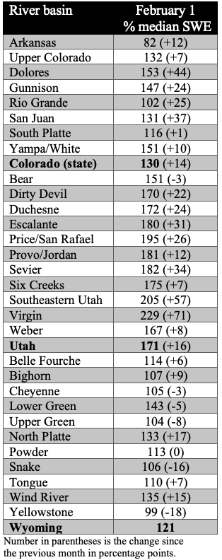
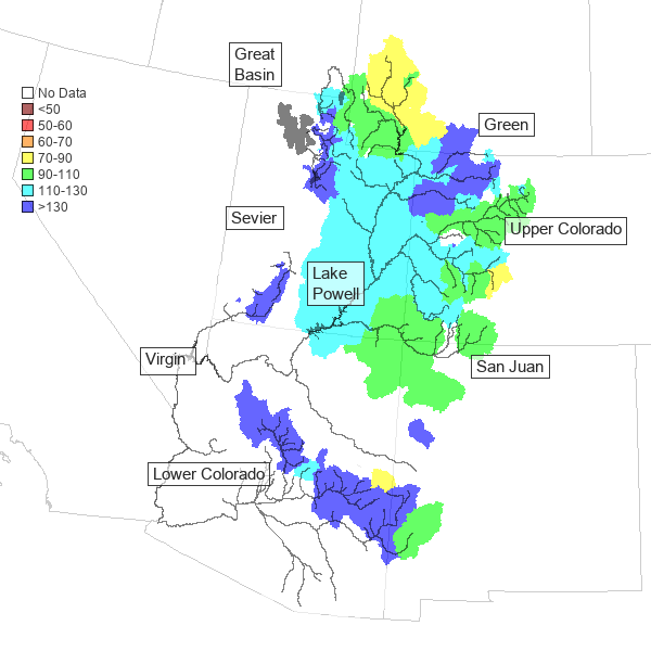
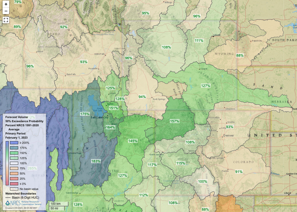
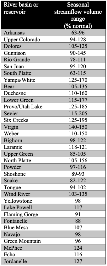
February 1st seasonal streamflow forecasts are above normal in the Upper Colorado and Great Basins, with much-above normal forecasts for the Six Creeks and Provo River basins. Near-normal seasonal streamflow volumes (90-110%) are forecasted for the Upper Colorado, Dolores, Upper Green, Gunnison, San Juan, Bighorn, Powder, Shoshone, Snake, and Tongue Rivers. Above normal seasonal streamflow (110-130%) is forecasted for the Bear, Weber, Laramie, North Platte, and Wind Rivers. Much-above normal seasonal streamflow (>130%) is forecasted for the Duchesne, Lower Green, Utah Lake, Sevier, Six Creeks, and Virgin Rivers. Seasonal streamflow forecasts for most large Upper Colorado River Basin reservoirs are near-normal with above normal forecasts for McPhee, Echo, and Jordanelle Reservoirs. The inflow forecast for Lake Powell is 117% of normal. East of the Continental Divide in Colorado, seasonal streamflow forecasts are below normal for the Arkansas, Rio Grande, and South Platte Rivers.
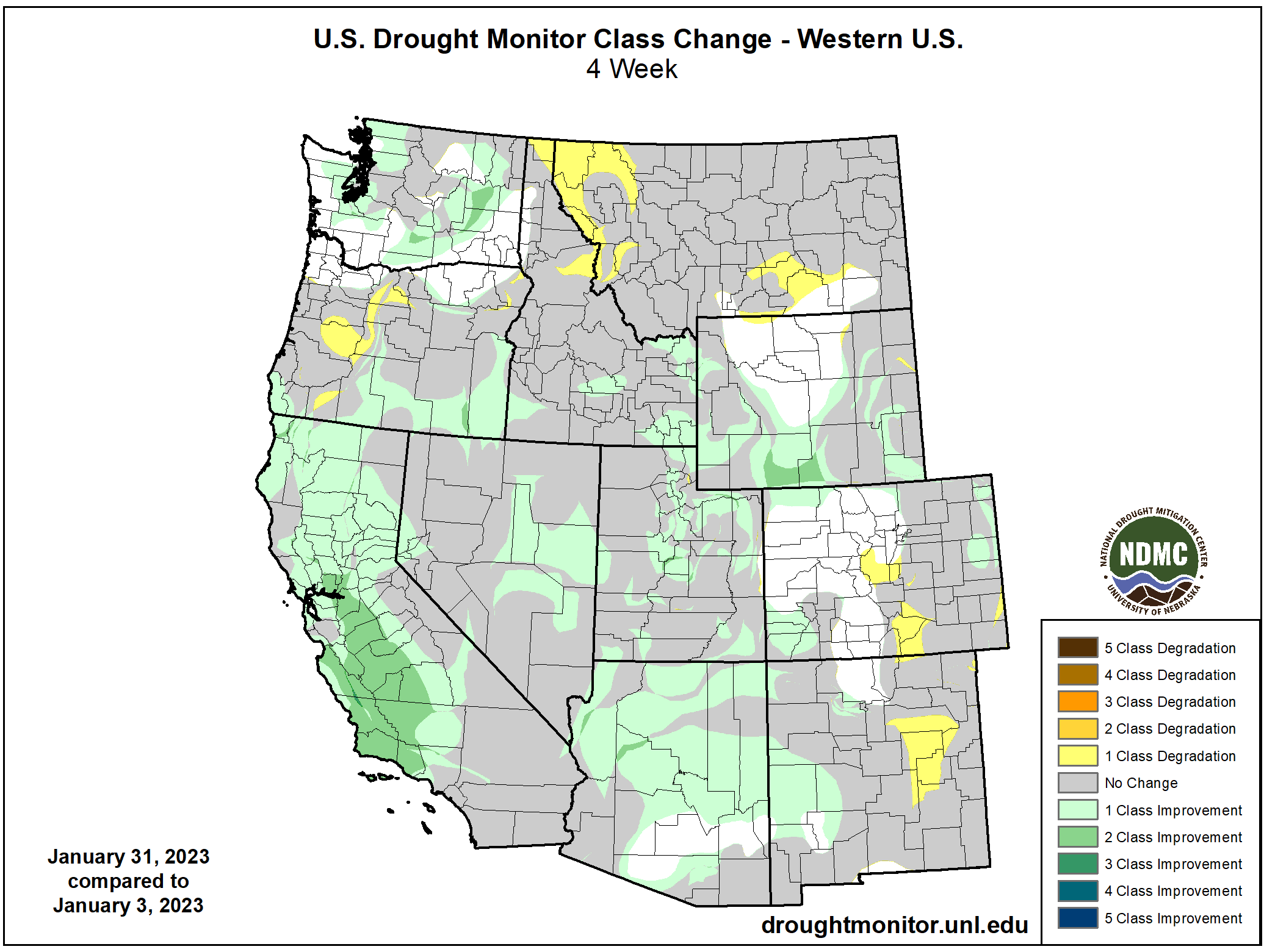
Regional drought conditions improved slightly in January. On January 31, drought covered 56% of Colorado, Utah, and Wyoming, down from 58% in early January. In Utah, there was a one category improvement in drought conditions over much of the north-central part of the state; exceptional drought was removed and extreme drought coverage decreased by 9% in January. In central Wyoming, drought conditions improved by 1-2 categories and extreme drought coverage decreased. Drought conditions in southern Colorado, east of the Continental Divide worsened during January.

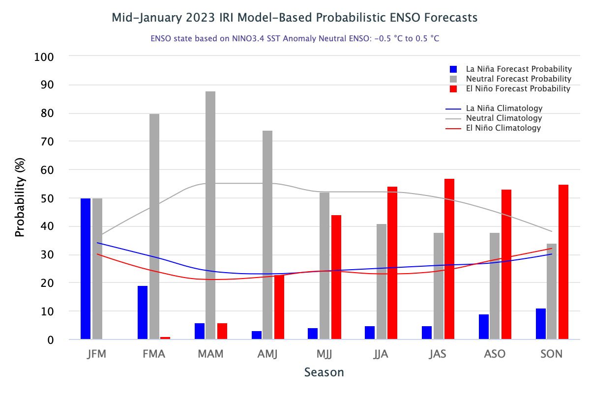
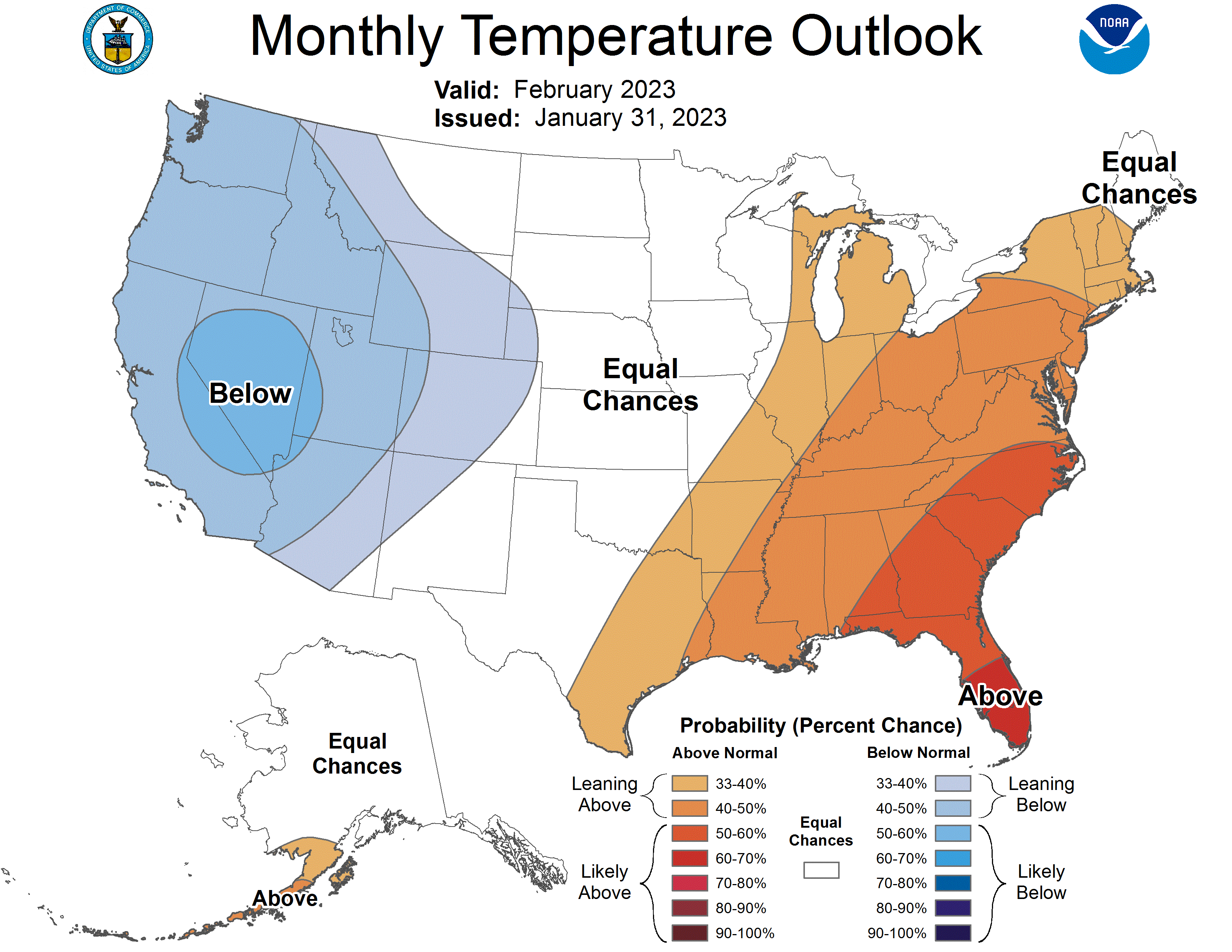
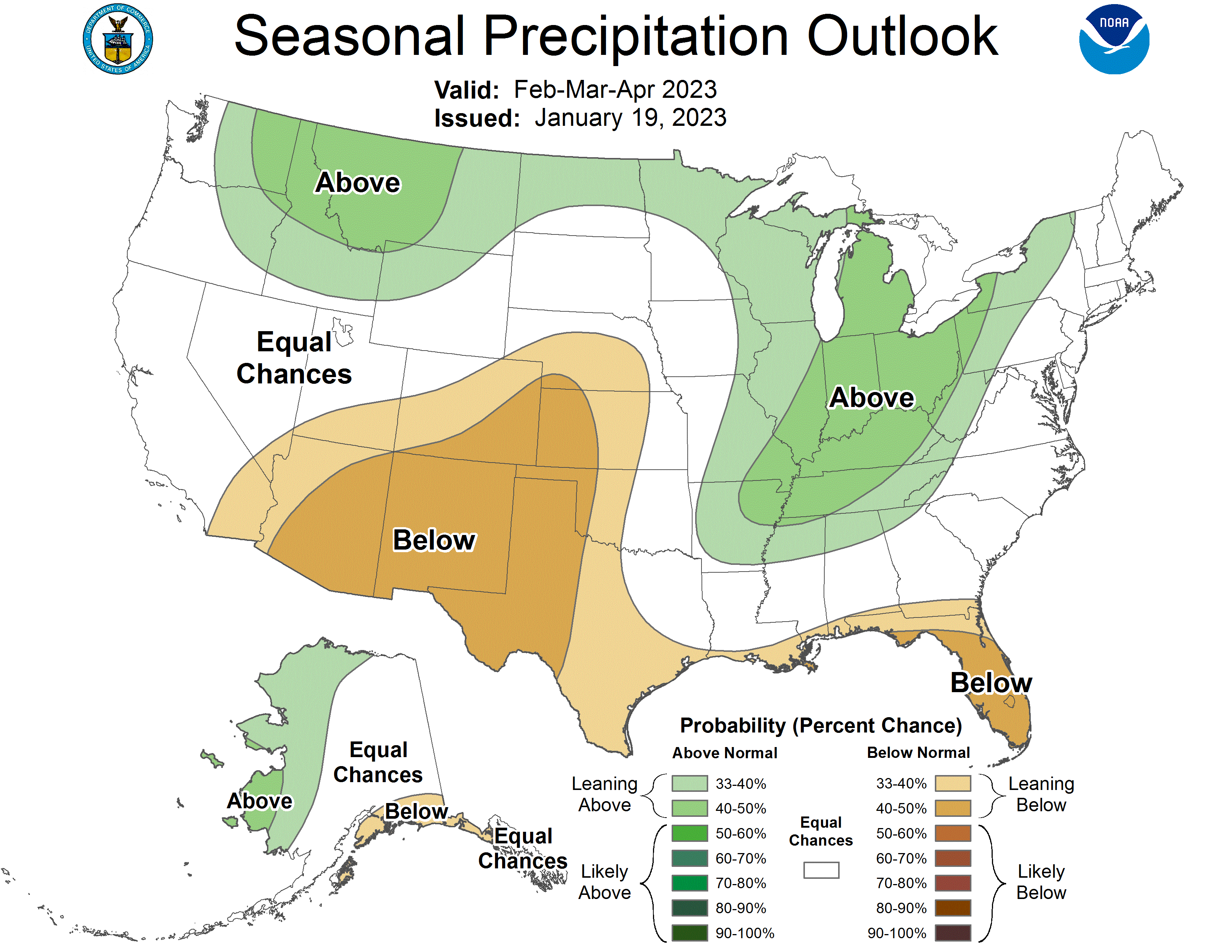
La Niña conditions persisted throughout January, but are forecasted to dissipate over the next 1-2 months. There is a 70-90% probability of neutral ENSO conditions during spring through early summer. By late summer, there is a 50% probability of El Niño conditions developing. The NOAA February monthly precipitation outlook suggests an increased probability of above average precipitation for northwestern Wyoming and equal chances of above or below normal precipitation for the rest of the region. The seasonal (February-April) precipitation outlook predicts an increased probability for above normal precipitation in northwestern Wyoming and below normal precipitation in southern Utah and much of Colorado. There is an increased probability of below normal temperatures for the entire region during February.

Significant January weather event: Snow, snow, snow! As of February 1st, Utah’s SWE was 171% of normal and all major basins in the state except for Raft River basin are above 150% of normal. Statewide SWE is 109% of Utah’s typical peak SWE, which guarantees an above normal snowpack season for much of Utah. Since SNOTEL sites were installed in Utah, the only years on record with more snow at the beginning of February were 1984 and 1997, making this winter the snowiest winter in 25 years. New SWE records were set in Utah as of February 1st. Three SNOTEL sites—Big Flat near Beaver, LaSal Mountain near Moab, and Vernon Creek near Vernon—reported a record-high SWE conditions compared to the last 30 years. The second-highest recorded SWE was observed at 11 additional sites. According to the NRCS Utah Snow Survey, the most probable outcome is for maximum SWE to reach 150% of normal. Considering the best-and-worst-case scenarios for the remainder of the winter, statewide SWE could range between 120% of normal to a new record-high statewide SWE.