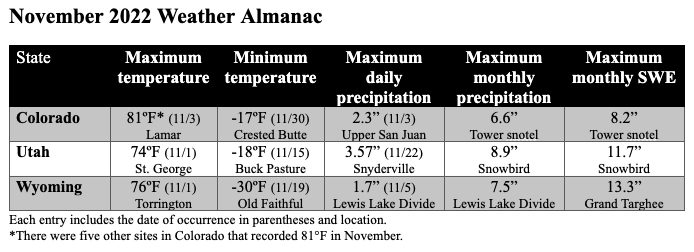
December 7, 2022 - CO, UT, WY
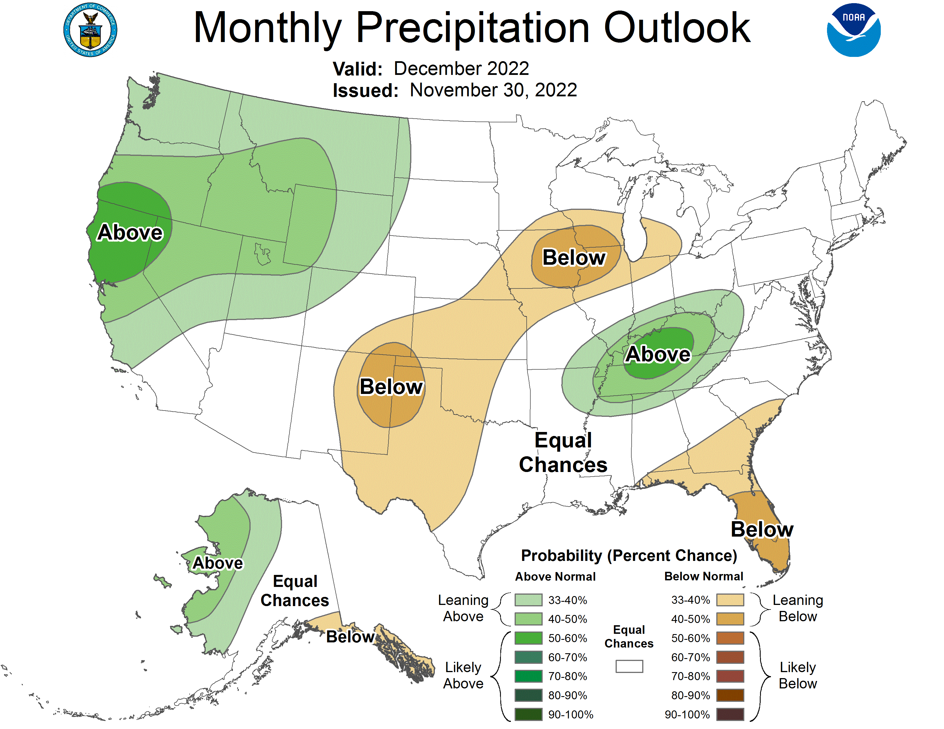
Regional precipitation was a mix of above to much-above normal conditions in northern and western Utah, western Wyoming, and northwestern Colorado, and below to much-below normal conditions in eastern Utah and Wyoming, and most of Colorado. Temperatures were below normal for the entire region. Regional snowpack is near normal for a majority of Colorado and Wyoming and is slightly above to much-above normal in Utah. Regional drought has slightly expanded, with a slight expansion in Wyoming, a slight improvement in Colorado, and a very slight improvement in Utah. La Niña conditions are expected to persist through winter, but will likely return to ENSO-neutral conditions by spring. NOAA December precipitation forecasts suggest an increased probability of above normal precipitation for most of Utah and Wyoming, while probabilities for above normal, below normal, and equal chances are split for Colorado.
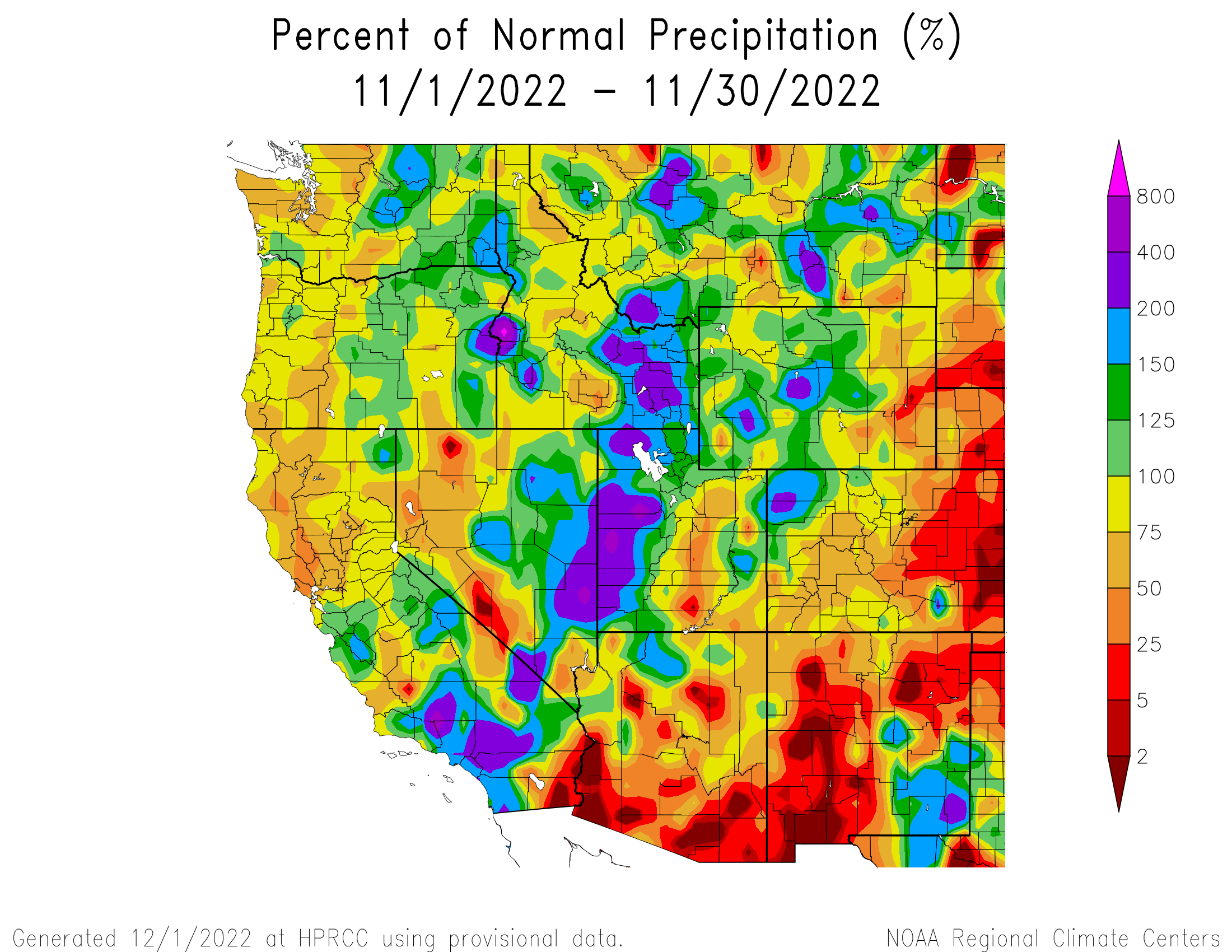
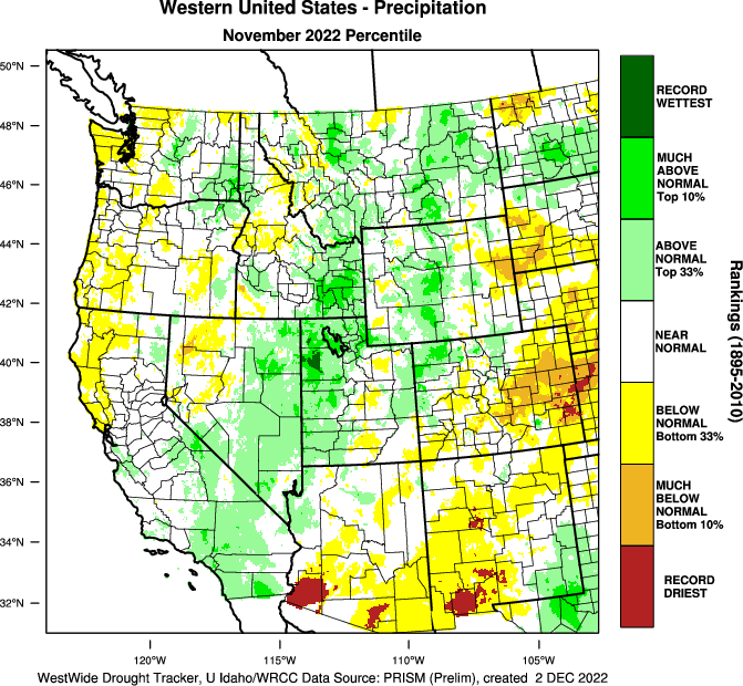
November precipitation was above normal (125-200% of average) throughout much of Utah, Wyoming, and northwestern Colorado, and much-above normal (200-800%) in western Utah. Precipitation was below normal (25-75%) in eastern Utah and eastern Wyoming, and was below normal to much-below normal (<25%) in Colorado. Record-wettest conditions were observed in Tooele and Box Elder Counties in Utah, and record-driest conditions were observed in Kit Carson, Cheyenne, Kiowa, Bent, and Prowers Counties in Colorado.
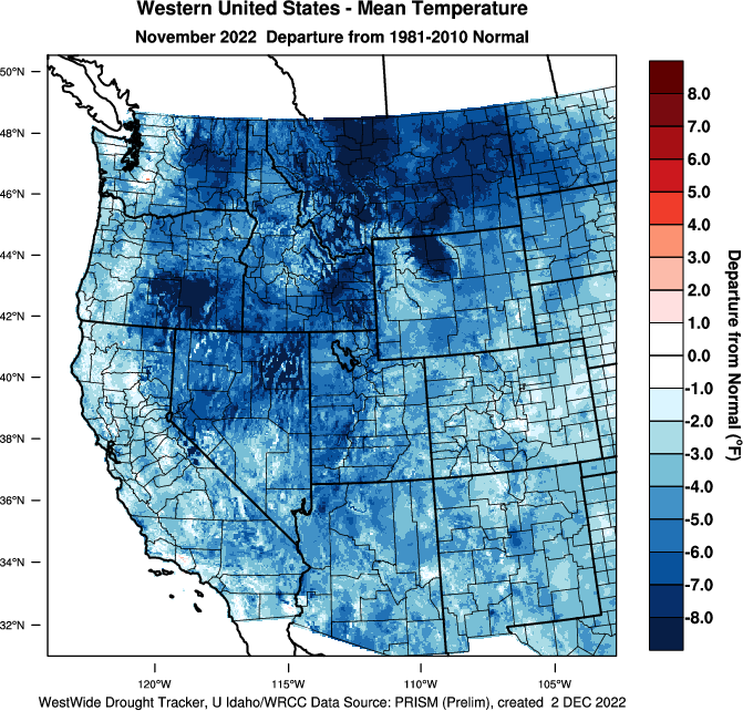
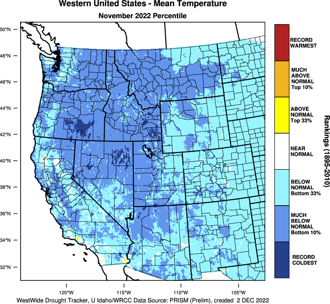
November temperatures were slightly below normal (0 to -3°F) to below normal (-3 to -9°F) for the entire region, with pockets of much-below normal temperatures (-9 to -15°F) in northwestern Wyoming and central Utah.

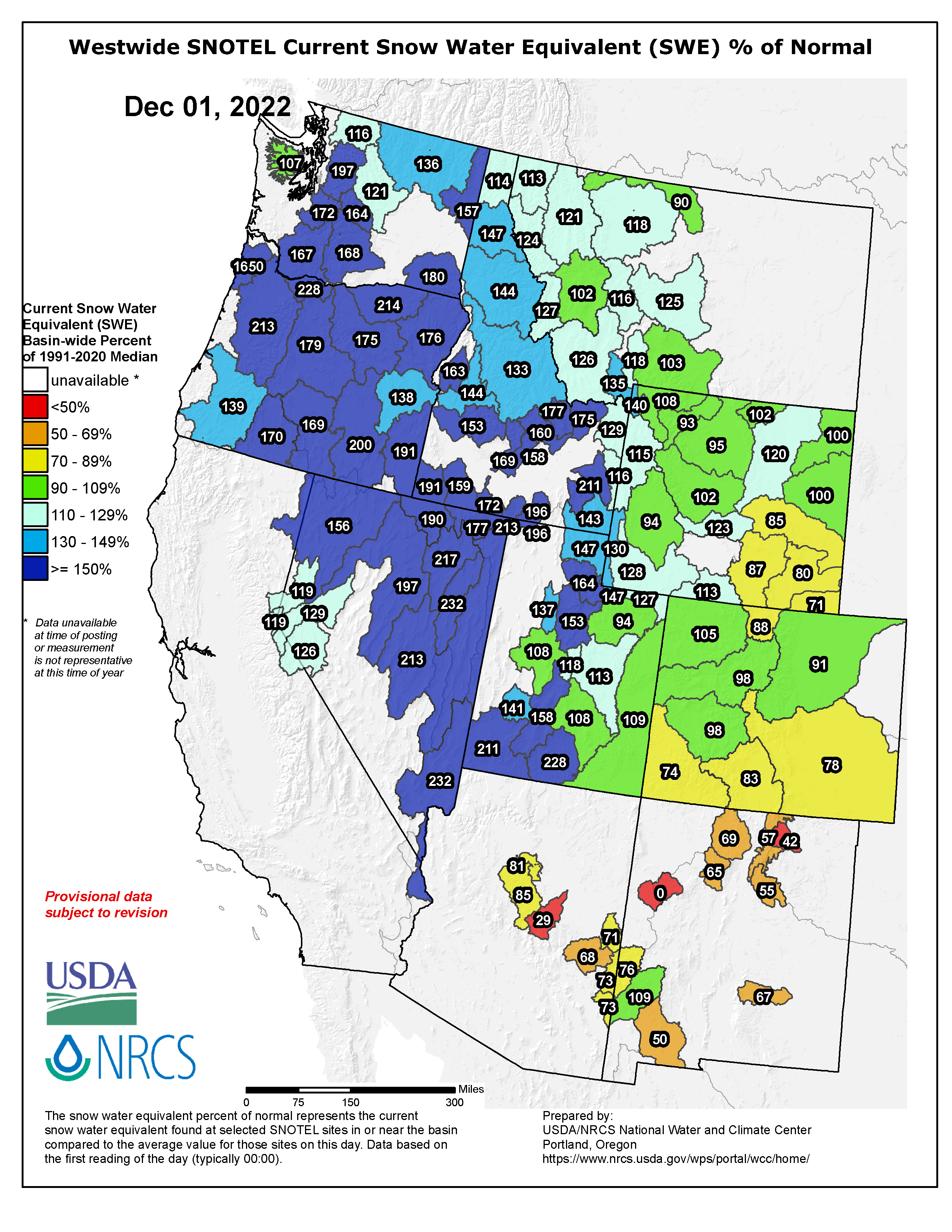
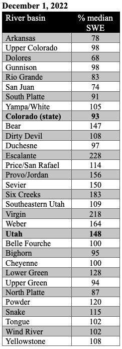
As of December 1st, snow-water equivalent (SWE) was much-above normal in northern and southwestern Utah and slightly above normal in eastern Utah. SWE was near-normal in much of northern Wyoming, above normal in parts of northern and southwestern Wyoming, and below normal in southeastern Wyoming. SWE was near-normal in northern Colorado and below normal in southern Colorado. It was the third snowiest November in Denver in the last 15 years. Most SNOTEL sites above 8,000 ft. reported 2-6” of SWE in Utah and Wyoming, and 1-4” in Colorado.
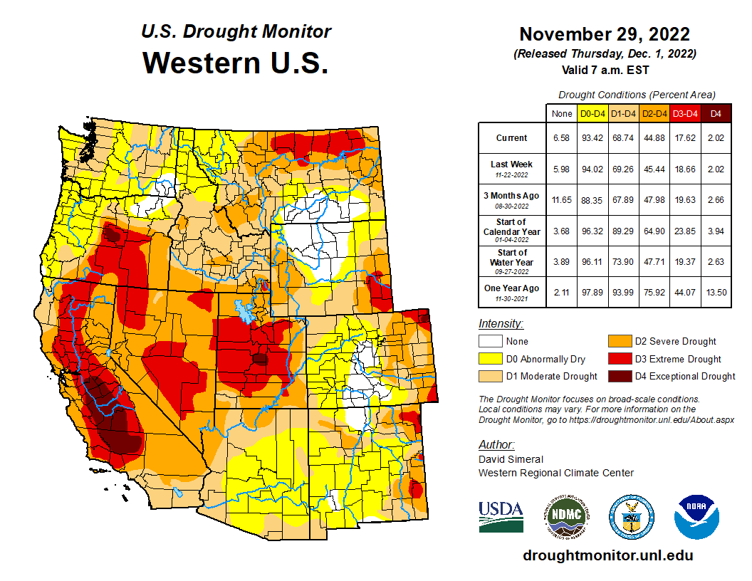
Regional drought coverage remained unchanged from October to November. Drought has been spatially consistent from October to November in our region (CO, UT, WY) with pockets of exceptional (D4) drought remaining particularly in Sanpete County in central Utah and Sedgwick and Phillips Counties in northeastern Colorado. Extreme (D3) drought has expanded to cover 6% of southeastern Wyoming and 4% of eastern Colorado. D3 drought continues to cover 50% of central Utah, although it has improved slightly. D3 drought was removed from the Green and Snake River basins in western Wyoming.
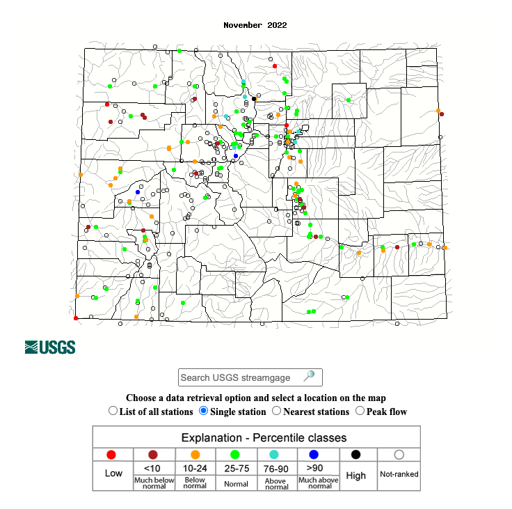
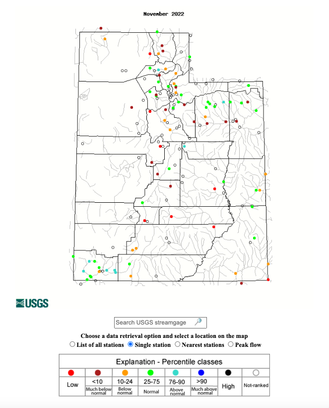
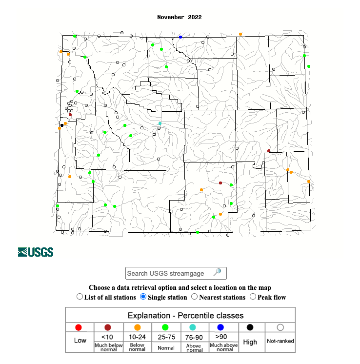
Record-low flows were observed at several locations, including the North Fork Cache La Poudre, San Juan, and White Rivers in Colorado; and the Bear, Dirty Devil, Fremont, San Rafael, and Sevier Rivers in Utah. Many sites in the region, particularly in Utah, recorded below to much-below normal November streamflows. However, there are also many sites throughout the region with normal streamflows, as well as above normal streamflows at six sites in Colorado, five in Utah, and one in Wyoming. There were a few sites that observed much-above normal streamflows, including Blue River in Colorado and Little Bighorn River in Wyoming.
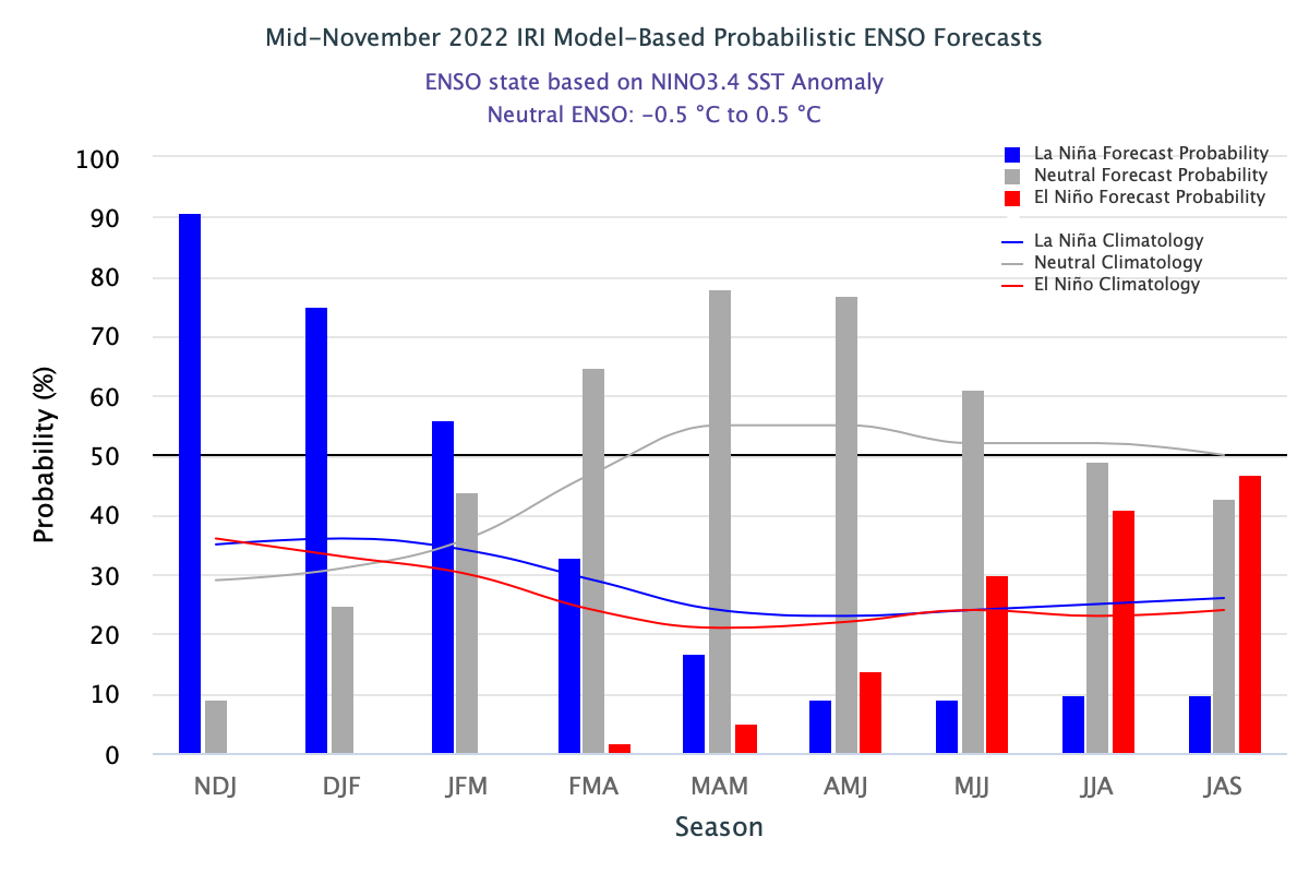
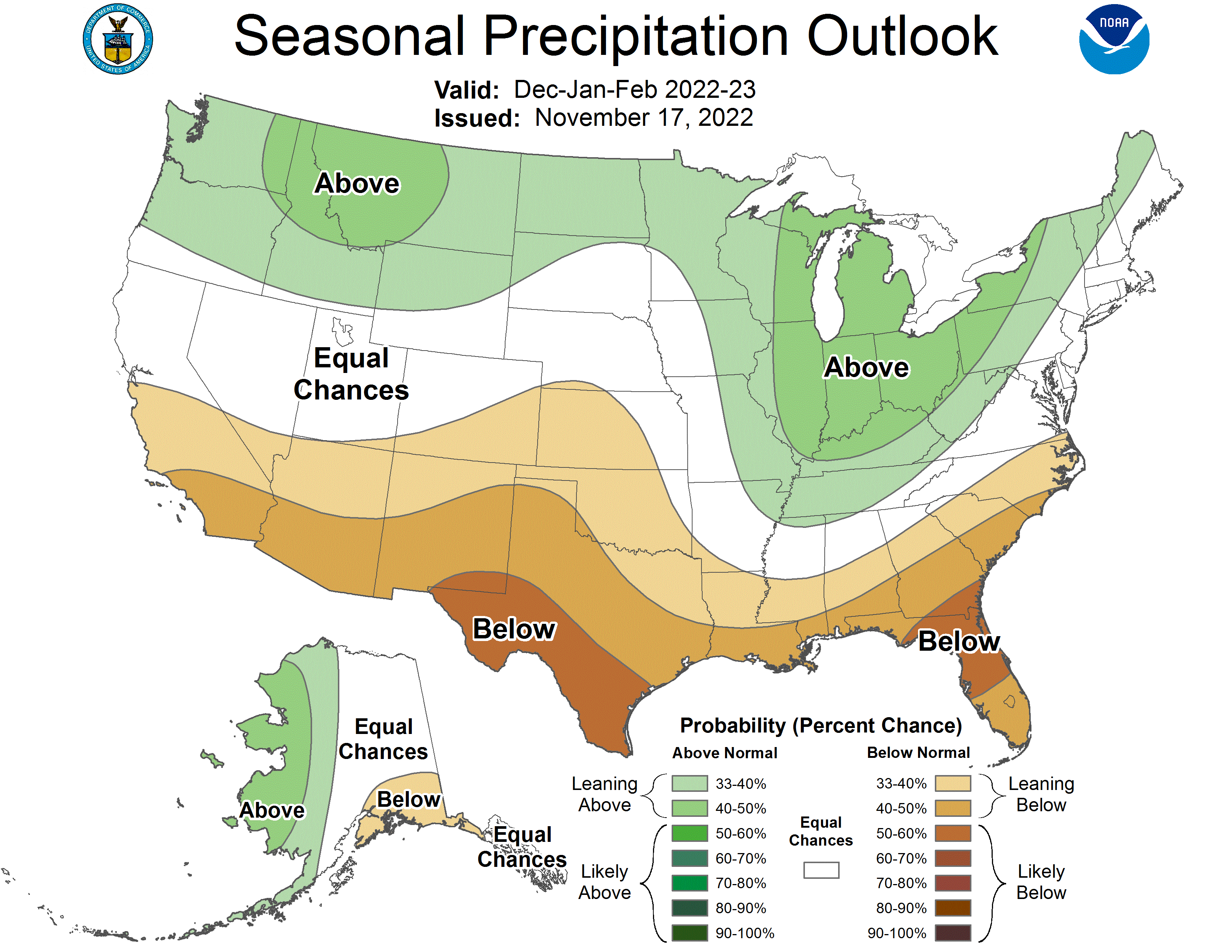
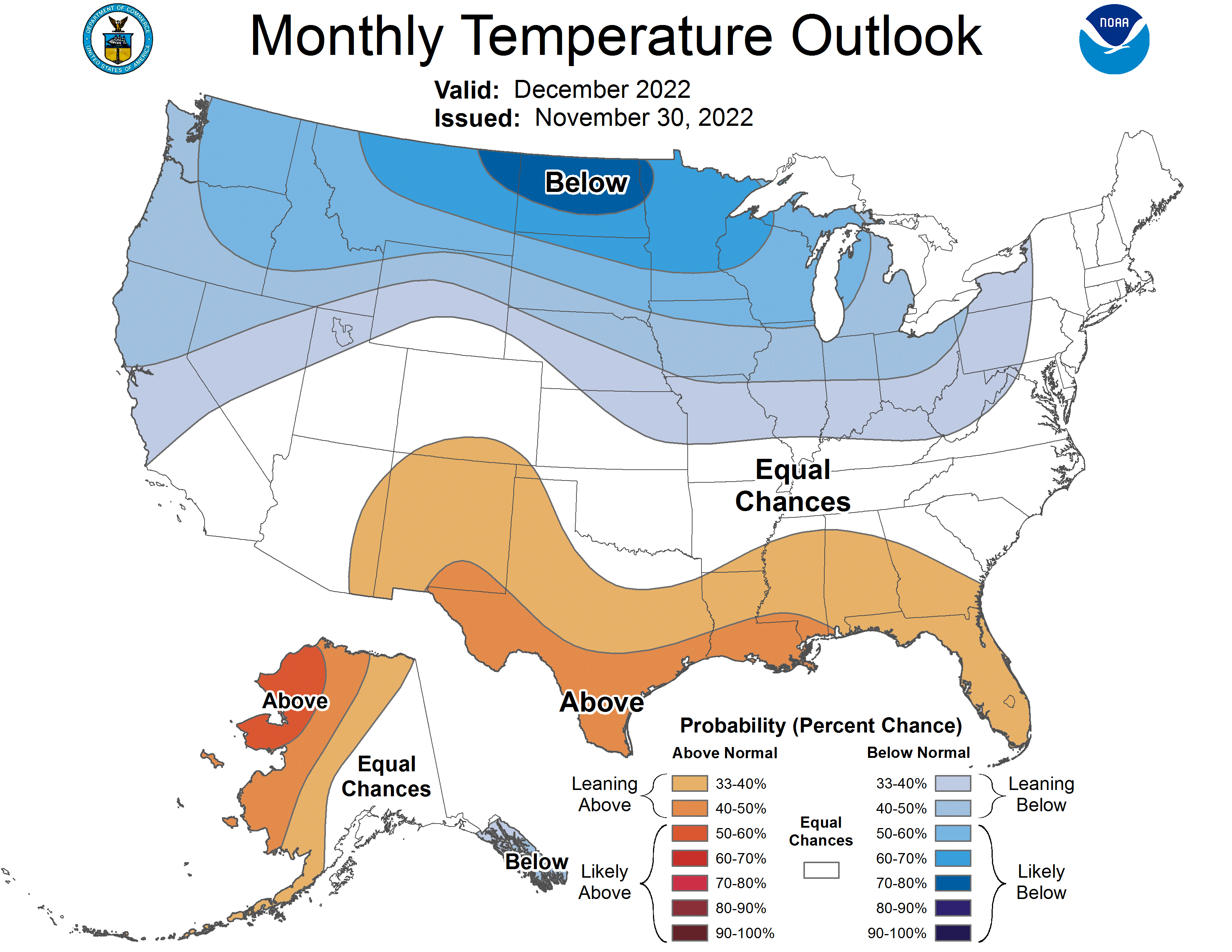
A La Niña advisory remained in place during November as below average sea surface temperature (SST) anomalies persisted in the equatorial Pacific Ocean and increased in the east-central Pacific Ocean, causing temperatures that were nearly 1°C below normal. SST models predict a 76% probability of La Niña conditions continuing through winter (December-February). However, ocean temperatures are projected to warm by the end of winter and there is a 65% probability of ENSO-neutral conditions by early spring (February-April). The NOAA monthly precipitation forecast for December indicates a 40-50% chance of above normal precipitation for western Wyoming and northern Utah, and a 33-40% chance of above normal precipitation in northwestern Colorado, central Utah from west to east, and most of eastern and central Wyoming. There is an increased probability of above normal temperatures in southern Colorado and below normal temperatures in northwestern Utah and central Wyoming from west to east. There are higher probabilities of below normal temperatures in northern Wyoming. Over this winter (December-February), the NOAA seasonal precipitation forecast predicts an increased probability of above normal precipitation in northern and central Wyoming and a 33-40% chance of below normal precipitation in southeastern Utah and southern to eastern Colorado. The seasonal temperature forecast shows a 33-40% chance of above normal temperatures in southern to western Colorado and southern to central Utah during the winter. The forecast shows a 33-40% chance of below normal temperatures in northern Wyoming this winter.

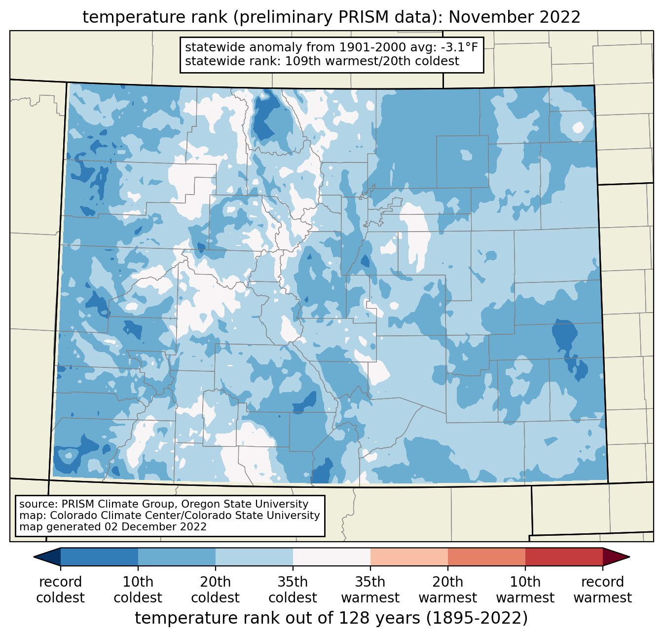
Significant November weather event: Colder than average temperatures covered the entire region with monthly temperatures ranging from 0 to -15°F below normal for the western U.S. Temperatures were coldest in northwestern Wyoming, where November temperatures were up to 8 degrees below normal in Park, Bighorn, Washakie, and Hot Springs Counties. The majority of Colorado and Wyoming experienced below normal temperatures (bottom 33rd percentile) and the majority of Utah experienced much-below normal temperatures (bottom 10th percentile). In Wyoming, Moose experienced its coldest November on record, Jackson and Lamar Ranger Station experienced their second coldest November on record, and Old Faithful and Tower Junction experienced their third coldest November on record. Denver and Salt Lake City had their coldest November since 2000 with average monthly temperatures of 35.6°F and 37.2°F, respectively. Statewide, November 2022 was Colorado’s 20th coldest November since 1895; temperatures were 3.1°F below the 20th-century average.