December 6, 2024 - CO, UT, WY
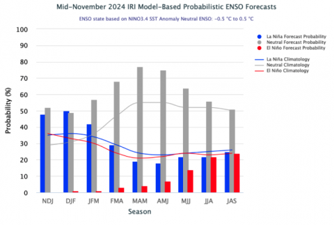
November precipitation was above average across central Utah and Colorado, much above average in eastern Colorado and below average across most of Wyoming, worsening the state’s drought conditions and low snowpack. Record 5-day precipitation totals in eastern Colorado aided in the removal of drought conditions. Regional temperatures were mostly below average, aiding the accumulation of snowpack, especially in Utah and Colorado where SWE conditions are average to above average. ENSO-neutral conditions prevailed in the Pacific Ocean during November and there is a 50/50 chance of neutral or La Niña conditions over the next few months.
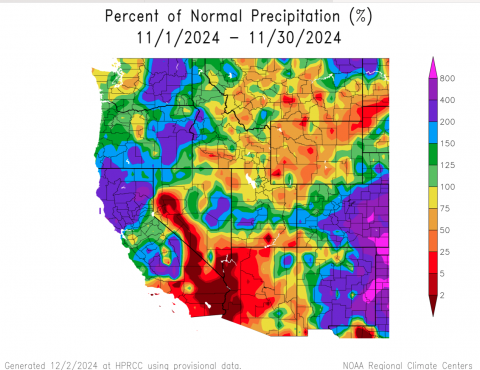
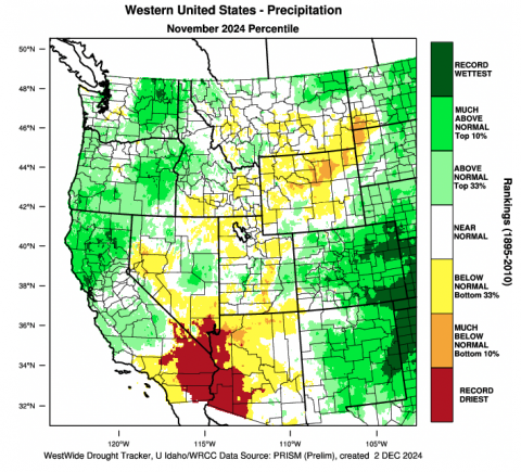
Colorado, central Utah and southwestern Wyoming received above average November precipitation while southern Utah and much of Wyoming received below average precipitation. Precipitation was 150-400% of normal for the central Colorado Rockies and the Eastern Plains received over 400% of average November precipitation. Baca County in the southeastern corner of Colorado received over 800% of average precipitation during November. Large areas of eastern Colorado saw record November precipitation. Extremely dry November conditions prevailed in far southern Utah and much of Wyoming, especially in the northeast corner of the state.
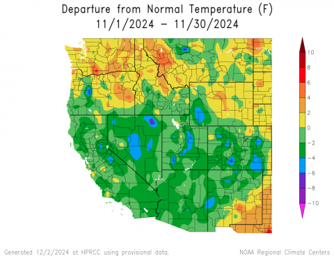
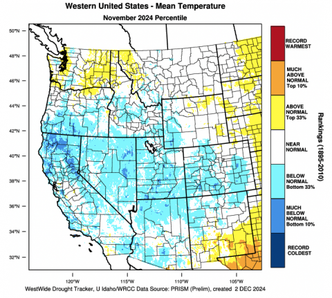
November average temperatures were below average in Utah, Colorado and southwestern Wyoming and near average across the remainder of Wyoming. Most of Utah, Colorado and southwestern Wyoming saw November temperatures that were up to 4 degrees below normal, but pockets of 4 to 6 degrees below normal were found in central and eastern Colorado, central Utah and southwestern Wyoming.
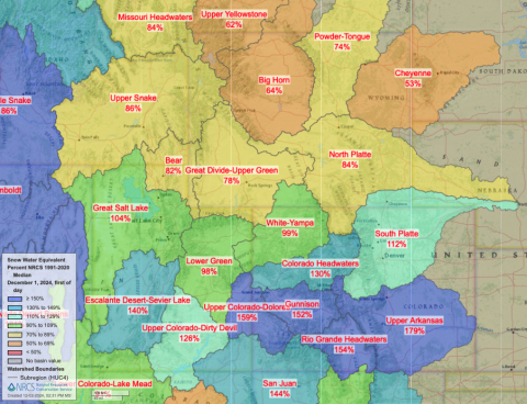
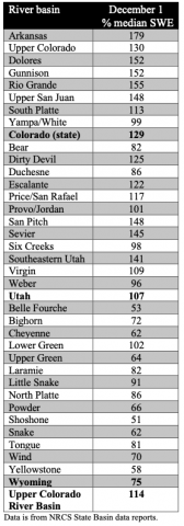
December 1st snow water equivalent (SWE) was near to above normal in Colorado and Utah and below normal in Wyoming. Much above normal SWE conditions on December 1 were present in the Arkansas, Upper Colorado, Dolores, Gunnison and Rio Grande River Basins. Much below normal SWE conditions existed in the Big Horn, Cheyenne and Yellowstone River Basins. On a statewide basis, December 1 SWE was 129% of normal in Colorado, 107% of normal in Utah and 75% of normal in Wyoming.
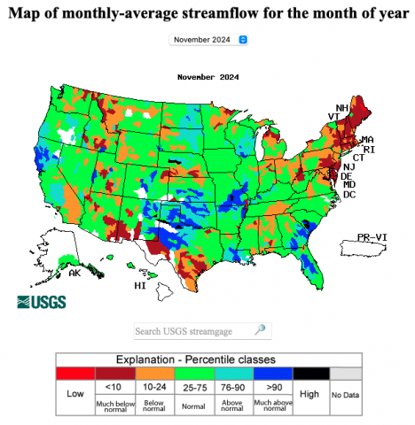
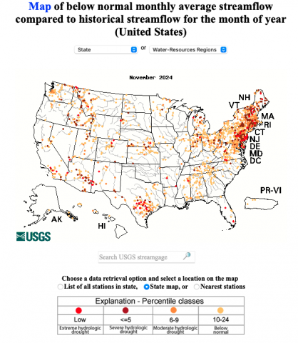
November streamflow in most of the region’s river basins was near average. Above average streamflow during November occurred in the Arkansas and South Platte River Basins. Much below normal November streamflow (<10th percentile of observations) was observed at sites in the Bear, Escalante, Fremont, Madison, Ogden, Sevier, Weber and Yellowstone River Basins. Record low November streamflow was observed at one site in the Cache La Poudre River Basin.
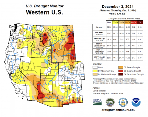
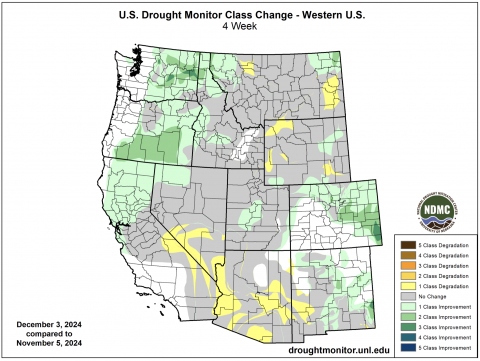
November precipitation, especially in Colorado brought significant improvements to regional drought conditions. As of December 3rd, drought covers 42% of the region, down from 53% of the region last month. Much above average November precipitation in Colorado caused the removal of a large area of drought and a reduction in the area of extreme drought. Drought conditions also improved in central Utah and parts of Wyoming. Severe drought conditions in northwestern Wyoming expanded during November.
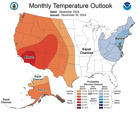
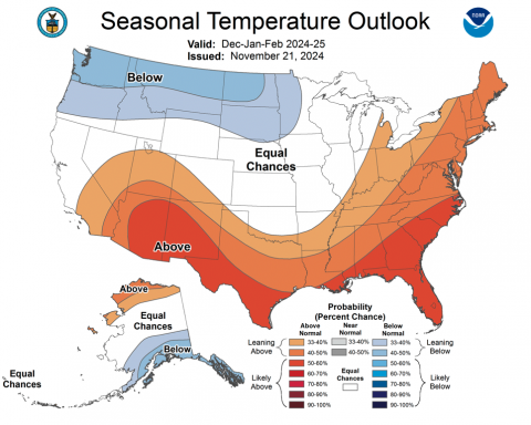
Sea surface temperatures in the Pacific Ocean during November remain consistent with neutral ENSO conditions. For the November-February period, there are near-equal chances of ENSO remaining neutral or weak La Niña development. By the February-April period, there is a 75% chance of ENSO-neutral conditions. NOAA seasonal forecasts for December and December-February indicate an increased probability for above average precipitation in northwestern Wyoming and an increased probability of below average precipitation for southern Colorado and southern Utah. During December, NOAA forecasts a high probability for above average temperatures. For the heart of meteorological winter, NOAA forecasts indicate an increased probability for above average temperatures in Utah and southwestern Colorado and an increased probability for below average temperatures in northern Wyoming.
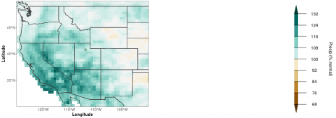
A new forecasting tool is now available on the Intermountain West Climate Dashboard under the Seasonal Outlook tab. The Experimental Winter Precipitation Forecast provides a prediction of December-March precipitation for the western United States using a novel model that incorporates both Pacific Ocean (ENSO) and Atlantic Ocean (Atlantic Quadpole Mode or AQM) along with historical observations of seasonal precipitation. The most recent Experimental Winter Precipitation Forecast uses September and October sea surface temperatures and indicates average to slightly above average precipitation for much of the region. Below average December-March precipitation is forecasted for eastern Colorado and eastern Wyoming. The next forecast, which will use September-November sea surface temperatures, will be available in mid-December.
November significant weather event: Heavy rainfall in eastern Colorado. On November 5-9, a series of two slow-moving storms caused record 5-day rainfall totals in eastern Colorado. Record 5-day rainfall totals for November were observed at 14 sites in eastern Colorado with at least 50 years of weather data. The highest 5-day precipitation total of 5.93” was observed in Walsh, CO which is nearly a third of average annual precipitation and the third highest 5-day precipitation total on record for that site. Heavy precipitation in Colorado facilitated the removal of drought from a large portion of the state that included up to a 3-category improvement in drought conditions.
