December 3, 2021 (CO, UT, WY)
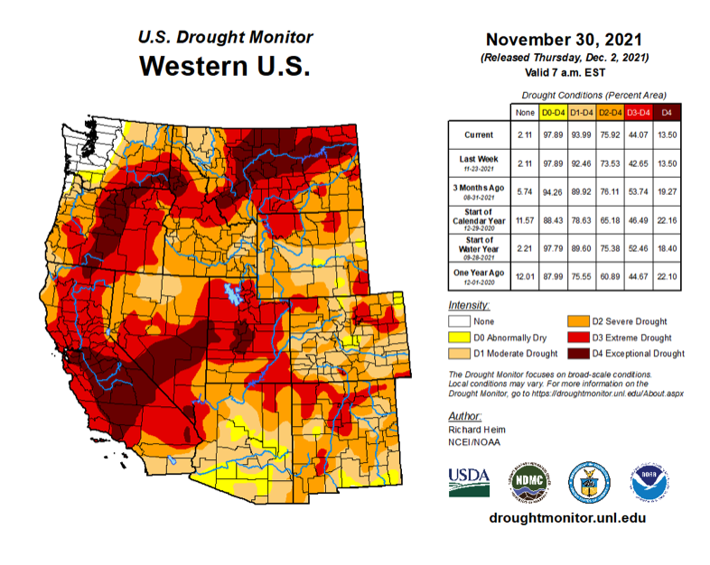
- November was warm and dry across the Intermountain West with some locations observing record heat and no precipitation. After a snowy October, November produced little snow and regional snowpack is much below normal with many sites breaking low precipitation records. Despite wetter conditions in July – October, streamflow in some regional rivers remains very low, especially in southern Utah and southwestern Colorado. Drought now covers 97% of the region; exceptional drought eased in Utah, but extreme drought expanded in northeastern Colorado and southeastern Wyoming. A La Niña advisory is in effect and La Niña conditions are expected to persist through winter. NOAA seasonal forecasts reflect a La Niña with an increased probability of above average precipitation in western Wyoming and an increased probability of above average temperatures and below average precipitation for southern Colorado and southern Utah.
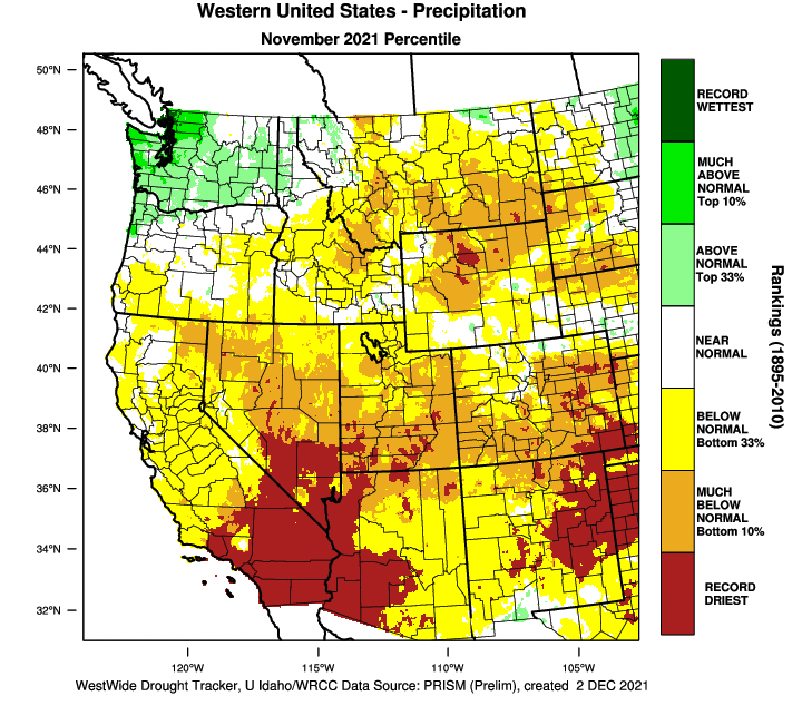
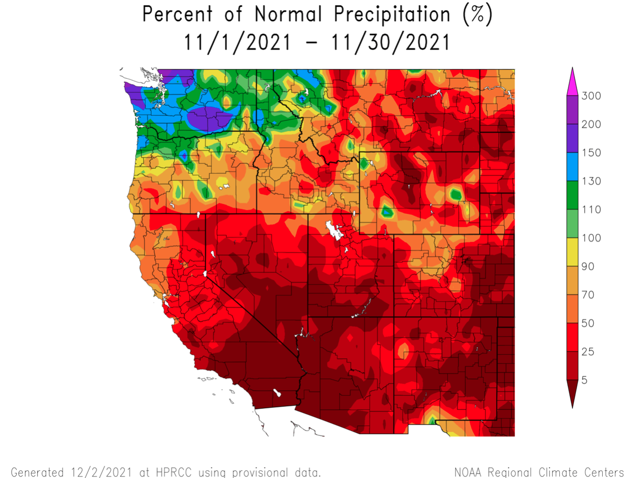
- In contrast to October, below average precipitation fell across the entire region during November. Less than 50% of normal precipitation was observed in Utah, most of Colorado and northern Wyoming. Large areas of southern Utah and Colorado received less than 25% of typical November precipitation. November precipitation was slightly higher (50-70% of normal) in parts of Wyoming and northern Colorado.
Image
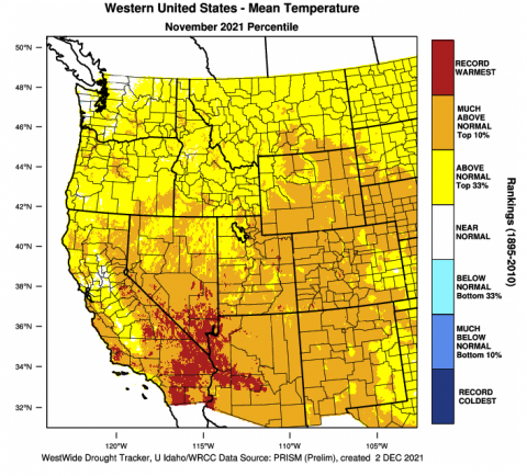
- Regional temperatures were much above normal during November. Temperatures throughout nearly all of Colorado and Utah were 4 to 6 degrees above normal. Temperatures in Wyoming and northern Colorado were mostly 6 to 8 degrees above normal and central Wyoming observed temperatures more than 10 degrees above normal.
Image

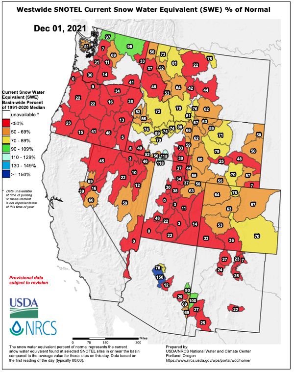
- After above normal snowfall during October, warm temperatures and low precipitation during November produced little accumulating snowfall. Consequently, regional snowpack on December 1st was much below normal. Snowpack in central Wyoming, northern Colorado and Colorado east of the Continental Divide was between 60-70% of normal, but only 35% of normal in southwestern Colorado. In Utah, snowpack was generally less than 40% of normal except for the Uinta Mountains. Snowpack in Wyoming was mostly 50-60% of average.
Image
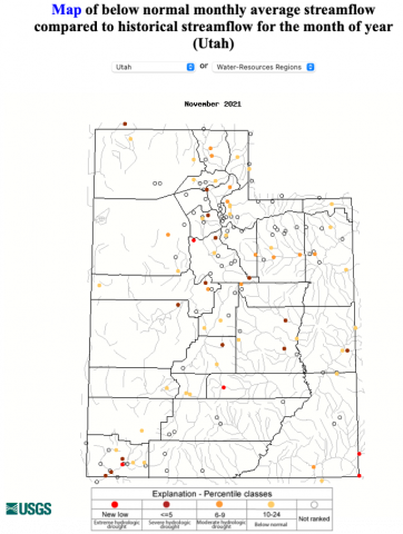
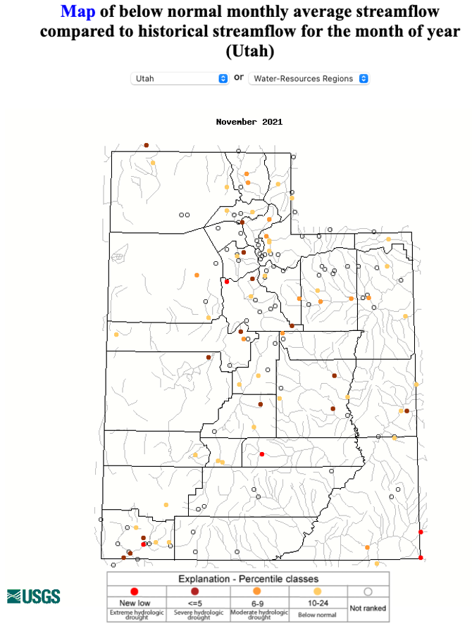
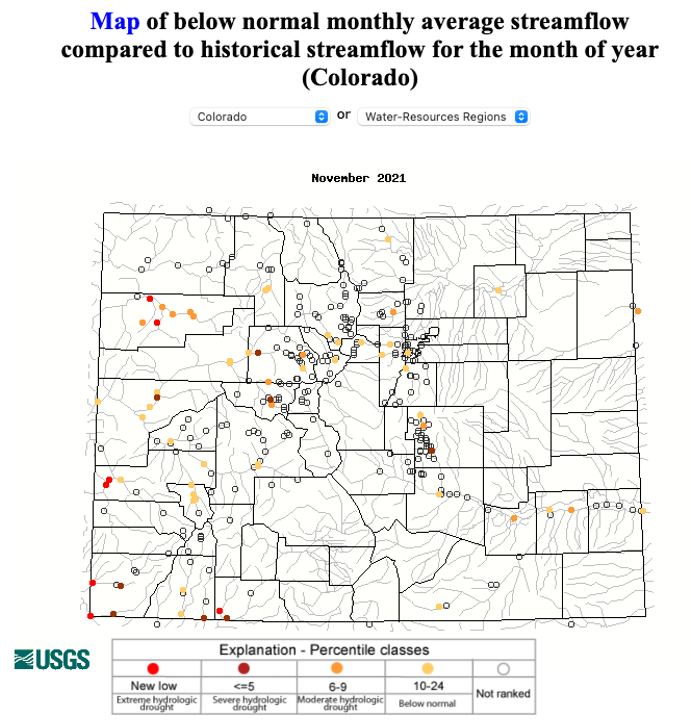
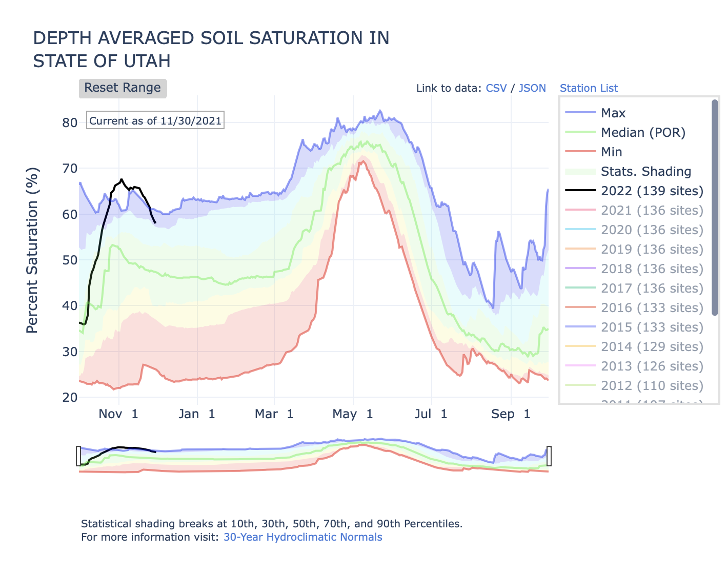
- Although streamflow has generally increased since during July, many important regional rivers continue to see much below average streamflow. Record low November streamflow was observed on the Dolores, Fremont, San Juan and Virgin Rivers. In Colorado, much below normal streamflow (<10th percentile) was observed on lower Arkansas, Roaring Fork and White Rivers. Much below normal streamflow was also observed on many Utah rivers including the Colorado (at Cisco), Duchesne, Logan, Price, San Rafael and Weber Rivers. Streamflow on Wyoming’s Snake and Wind Rivers was also much below normal during November. On a more optimistic note for future streamflow, soil moisture in Utah (from 139 sites including Snotel) continues to be much above average despite a warm and dry November.
Image
 Image
Image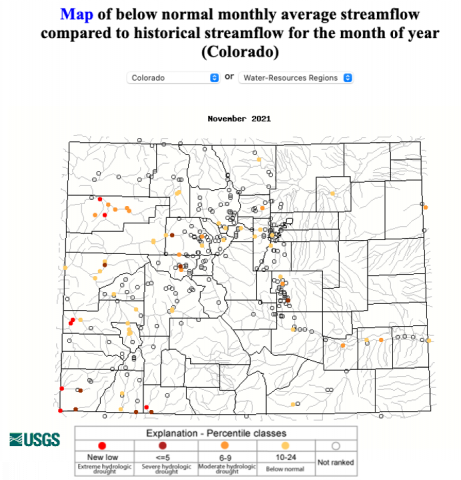 Image
Image
- Overall coverage of regional drought increased slightly during November and drought now covers 97% of the region. East of the Continental Divide in Colorado experienced the greatest expansion of drought, including the emergence of D1 and D2 drought in southern Colorado and the emergence of D3 drought in northeastern Colorado. Drought conditions in Utah generally remained the same throughout November, except for a contraction of an area of D4 drought in central Utah. An area of D3 drought emerged in southeastern Wyoming and D1 drought developed in central Wyoming.
Image
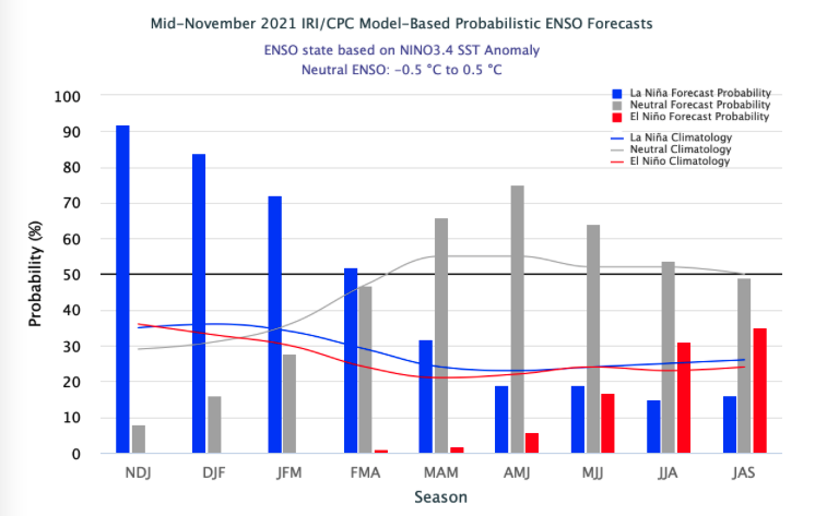
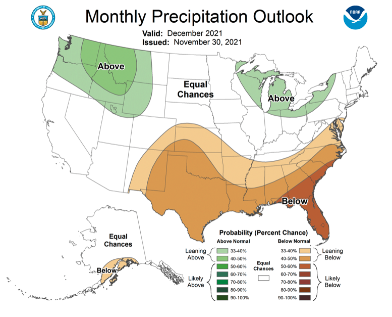
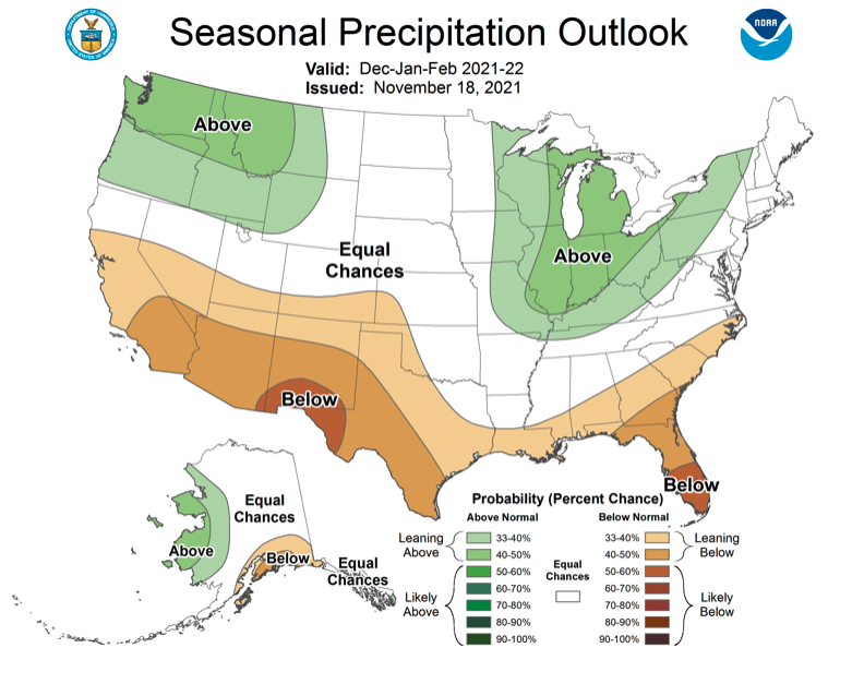
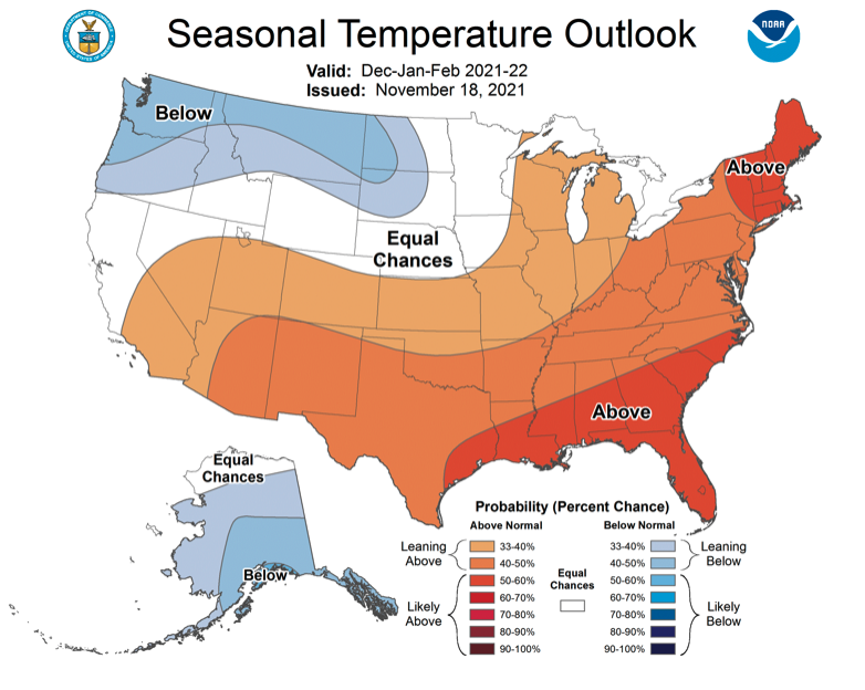
- A La Niña advisory remained in place during November as east-central Pacific Ocean temperatures were nearly 1ºC below normal. Sea-surface temperature models predict an 80% probability of La Niña conditions continuing through winter and a 70% probability of ENSO neutral conditions prevailing by summer. The NOAA seasonal forecast for December indicates a 33% chance of above average precipitation for western Wyoming and northern Utah. There is an increased probability of above average temperatures for the entire region, especially in southern Colorado and southern Utah. Over winter (Dec-Feb), the NOAA seasonal forecast predicts a 33% probability of above average precipitation in western Wyoming and a 33% chance of below average precipitation in southern Colorado and southern Utah. Temperatures will likely be above average in Colorado and Utah during winter.
Image
 Image
Image Image
Image Image
Image
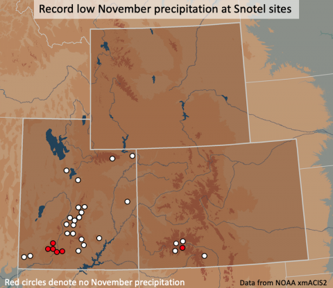
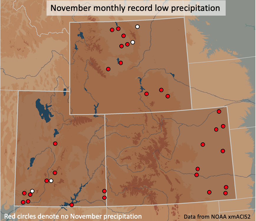
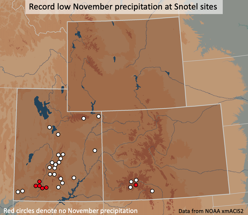
- Significant November weather event. Extremely warm and dry conditions covered the entire region during November. Looking at temperatures on a regional scale, November temperatures were mostly in the warmest 10% of years. However, looking at a finer resolution, 22 sites (with at least 50 years of data) across the region experienced the hottest November on record. As of November 21st, Denver, CO officially broke the record of latest first snowfall; Denver still awaits its first snowfall. In most of Utah, southern Colorado and northern Wyoming, November precipitation was in the lowest 10% of the historical record with many locations experiencing the driest November on record. Across the region, 34 sites observed the driest November on record with 30 of those sites receiving no precipitation. With an eye towards the upcoming water year, an examination of Snotel sites with at least 30 years of data reveals 27 sites in Utah and 5 sites in Colorado with the driest November on record. Six snotel sites recorded no precipitation during November.
Image
 Image
Image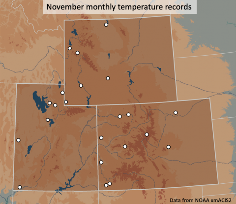 Image
Image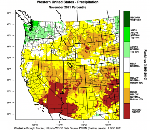 Image
Image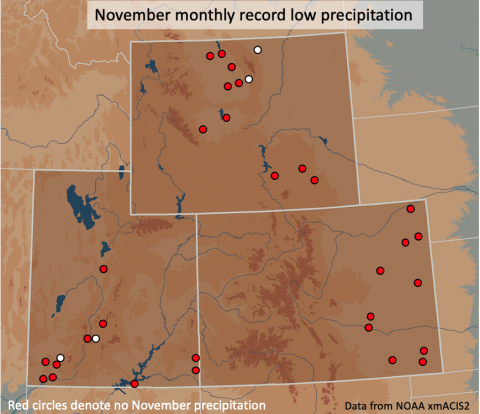 Image
Image