August 6, 2024 - CO, UT, WY
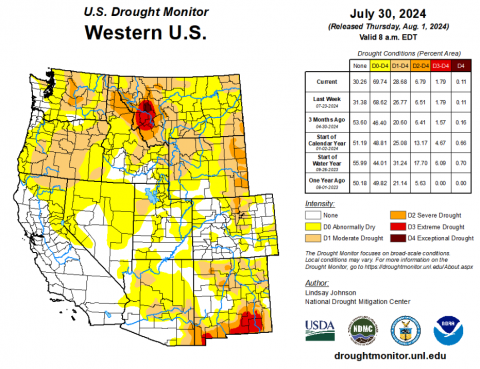
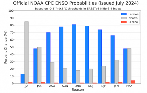
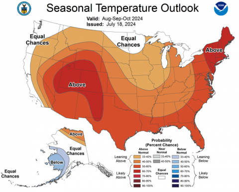
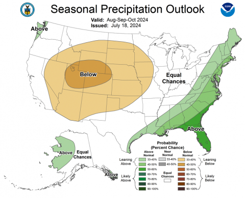
A hot and dry July caused expansion of drought conditions across the region. Intermountain West drought coverage expanded from 9% on July 2 to 23% on July 30 driven by drought conditions in eastern Wyoming and the northern Front Range. Regional streamflow conditions were generally below average, but regional reservoir storage is above average in Utah and near average in Colorado and Wyoming. La Niña conditions are predicted to return by early fall and there is a high probability of above average temperatures and below average precipitation for the region during August-October.
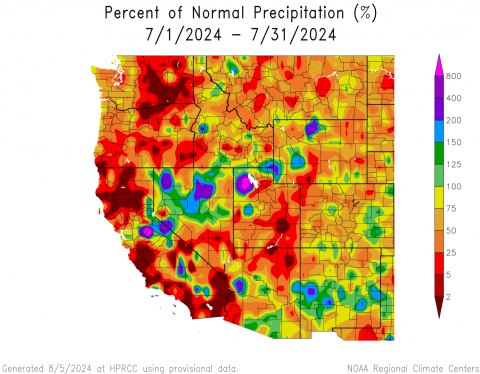
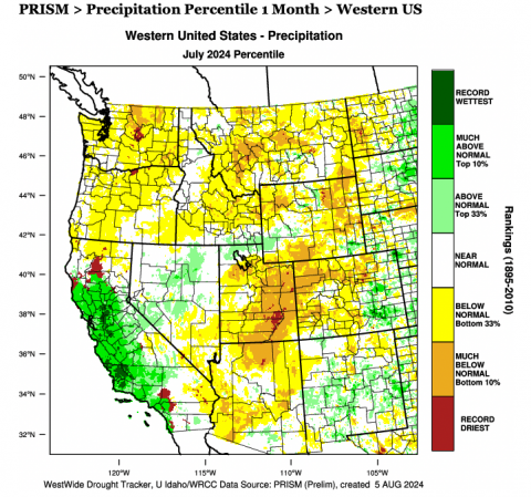
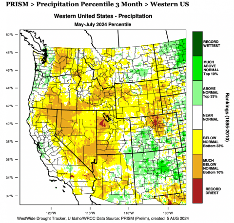
Regional precipitation was mostly below average during July. The driest conditions were observed in Utah where the majority of the state received less than 50% of normal July precipitation and SNOTEL sites recorded a statewide 53% of average precipitation. Record-dry July conditions were observed near the confluence of the Green and Colorado Rivers. Large portions of Colorado received less than 75% of average July precipitation with SNOTEL sites recording 76% of average July rainfall. Much of Wyoming also received less than 75% of average July precipitation with SNOTEL sites reporting 82% of average July rainfall. Pockets of above average July precipitation were observed across northwestern Utah and northwestern Wyoming. Despite below average July precipitation, regional water-year precipitation remains near-average.
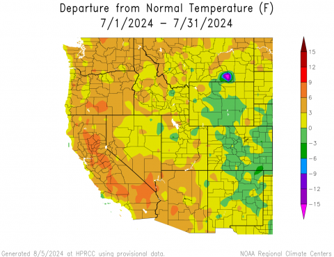
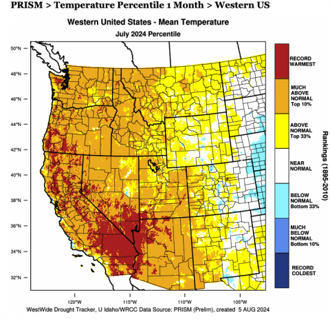
July temperatures were generally above average west of the Continental Divide and below average east of the Divide. July temperatures in much of Utah, western Colorado and western Wyoming were up to 3 degrees above normal with southern Utah recording July temperatures 3-6 degrees above average. July temperatures in central Wyoming and Colorado east of the Divide were below average.
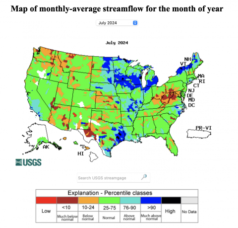
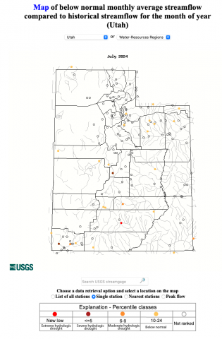
As regional hydrology approaches baseflow conditions, July streamflow was near average in much of the region. Below average streamflow conditions were observed in western Wyoming, southern Utah and the Dolores River Basin. In Utah, July streamflow was in the lowest 10% of observations for the Escalante, Fremont, Sevier and Virgin Rivers.
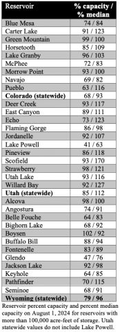
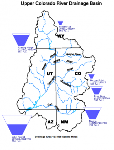
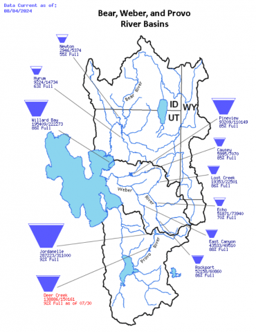
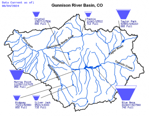
Two years of average to above average precipitation leaves regional reservoirs at water storage amounts near-to-above average. In Colorado, reservoirs are 68% full and 93% of median capacity; Utah reservoirs are 85% full and 112% of median capacity; Wyoming reservoirs are 79% full and 96% of median capacity. Upper Colorado River Basin Reservoirs have the most cumulative storage since 2020 with Fontanelle 85% full, Flaming Gorge 88% full, Navajo 70% full, Blue Mesa 74% full and Lake Powell 41% full. Wasatch Front reservoirs are particularly full with Weber River Basin reservoirs at 87% of capacity and Provo River Basin reservoirs at 92% capacity.
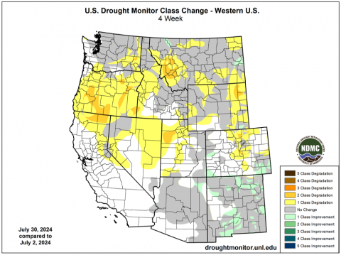
After months of relatively little change in regional coverage of drought, drought coverage expanded during July to cover 23% of the region, compared to 9% of the region covered by drought on July 2. Severe drought (D2) developed in eastern Wyoming and the northern Front Range. Moderate drought conditions developed in the Great Salt Lake Desert and expanded in northwestern Wyoming, eastern Wyoming and the northern Front Range. Moderate drought conditions were removed from southeastern Colorado near the Arkansas River.
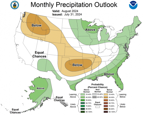
ENSO-neutral conditions currently exist in the eastern Pacific Ocean and there is a 70% probability of La Niña conditions developing by early fall. NOAA seasonal forecasts suggest a hot and dry August-October. For most of the region, there is a 60-70% chance of above average temperatures during August-October. In August, there is an increased probability of below average precipitation for Wyoming and eastern Colorado. On the three-month timescale, there is an increased probability of below average precipitation for the entire region.
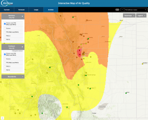
Severe drought and wildfires on the Front Range. Severe drought conditions developed across the northern Front Range of Colorado during July. Despite near-average water year precipitation along the northern Front Range, May-July precipitation was the lowest on record in parts of Boulder and Larimer Counties. The rapid development of drought was accompanied by the ignition of several wildfires, the Alexander Mountain Fire (10,000 acres, west of Loveland), the Stone Canyon Fire (1,500 acres, west of Longmont) and the Quarry Fire (southwest of Littleton) on 7/29 – 7/31. Wildfire smoke from these fires, mixing with smoke from other western fires, caused poor to extremely poor air quality from Colorado Springs to Fort Collins on 7/29 – 8/4. Boulder, Denver, Fort Collins and Greeley experienced orange air quality (unhealthy for sensitive groups) for ozone during this period. In Colorado Springs, orange air quality conditions due to ozone pollution were present from 7/31 – 8/4. Red or unhealthy air quality conditions were observed in Boulder and Denver from 7/31 – 8/2 with high PM2.5 pollution co-occurring on 8/1. Spikes in ozone pollution during periods with wildfire smoke can occur even if particulate matter from smoke is low or moderate.
