April 7, 2023 - CO, UT, WY
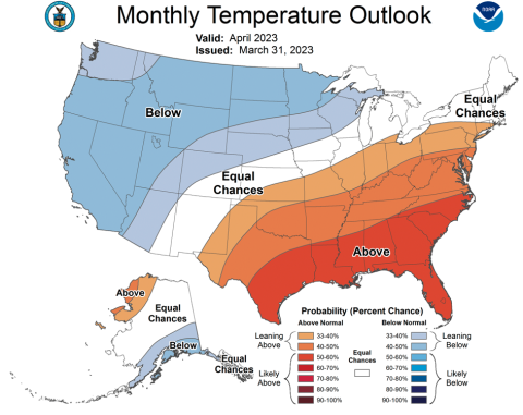
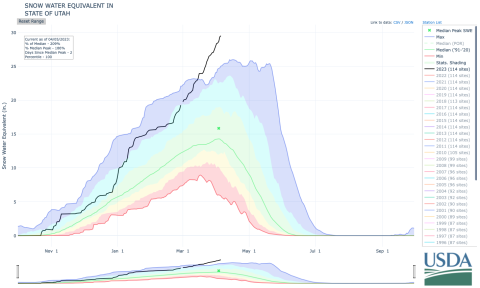
Record snowfall continued across many portions of the region during March. Record-high April 1st snow-water equivalent values were observed in Utah and western Colorado and the 2023 Utah statewide average surpassed the previous record set in 1983. Streamflow volume forecasts are above to much-above average for the Upper Colorado River and Great Basins and the inflow forecast for Lake Powell is 177% of average, providing much-needed water after record-low water levels. Regional drought conditions improved during March, especially in Utah, and 45% of the region is currently in drought. There is an increased probability of below average regional temperatures during April which would contribute to flooding risk in portions of the region with very large snowpacks.
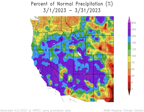
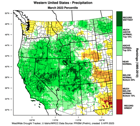
March precipitation was much-above normal in Utah and western Colorado, above normal in western Wyoming, and generally below normal in eastern Colorado and eastern Wyoming. In Utah and western Colorado, precipitation was 150-400% of normal during March; half of Utah observed 200-400% of normal March precipitation. March precipitation was 25-75% of normal for most of Colorado and Wyoming east of the Continental Divide, except for the Bighorn Mountains in northern Wyoming where March precipitation was near-normal.
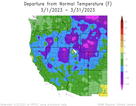
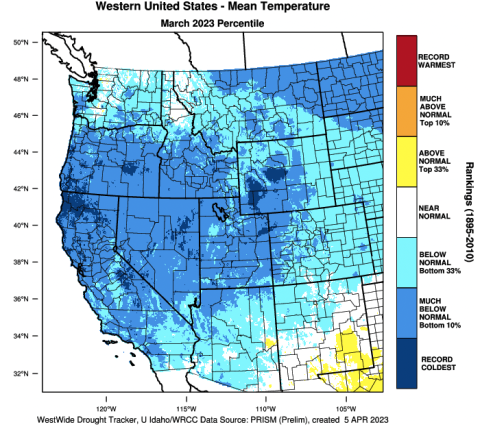
Regional temperatures were below normal during March. The coldest conditions were observed in western Wyoming where temperatures were 9-15 degrees below normal; temperatures in parts of southwestern Wyoming were the coldest on record. In Utah and northwestern Colorado, March temperatures were generally 6-12 degrees below normal and March temperatures were among the 12 coldest on record. Southeastern Colorado was the regional hot spot where temperatures were 3-6 degrees below normal.
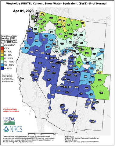
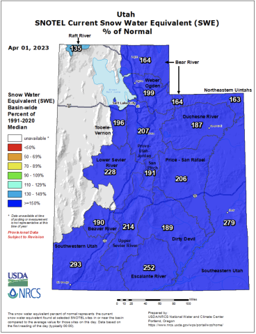
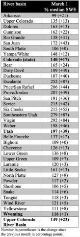
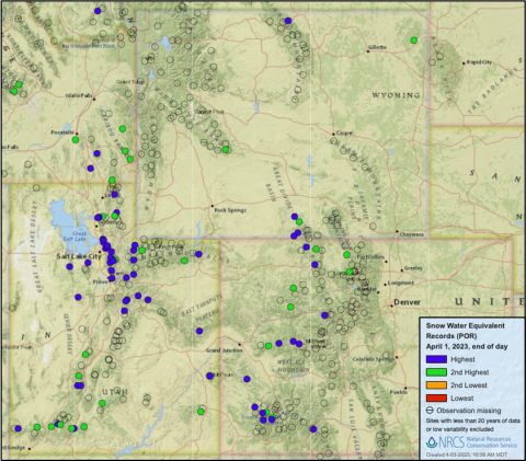
Regional snowpack is above average for the entire region except for the South Platte and Arkansas River Basins where April 1 snow-water equivalent (SWE) is near-average. For much of Utah and western Colorado, record-high SWE conditions exist. On April 1st, statewide average SWE in Utah was 197% of normal and average SWE was 28.4”, shattering the previous statewide SWE record of 26” set in 1983. In Colorado, April 1st statewide SWE was 140% of average. Snowpack in Colorado was generally near-normal east of the Continental Divide and much-above normal west of the Divide, including the Dolores River Basin which is at a record-high 165% of average. Wyoming snowpack is above normal statewide (117% average) with near-normal April 1st SWE in the Bighorn, Upper Green, Shone, and Yellowstone River Basins and above average SWE conditions across the remainder of Wyoming.
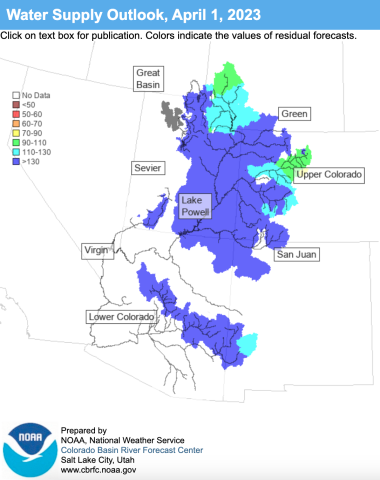
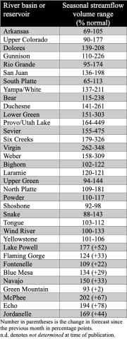
Seasonal streamflow volume forecasts are above average to much-above average for most regional river basins. Streamflow forecasts are highest for the Great Basin where forecasted volumes are 115-450% of average. Below normal (60-90%) to near-normal (90-110%) seasonal streamflow volumes are forecasted for the Arkansas, South Platte, Shoshone, Tongue, and Yellowstone Rivers. Above normal seasonal streamflow (110-130%) is forecasted for the Bighorn, Laramie, Powder, and Wind Rivers. Much-above normal seasonal streamflow (>130%) is forecasted for the remaining regional river basins, with streamflow forecasts above 300% for the Lower Green, Provo/Utah Lake, Sevier, Six Creeks, Virgin, and Weber Rivers. Seasonal streamflow forecasts for most large Upper Colorado River Basin reservoirs are much-above normal with only near-to-above normal forecasts for Green Mountain, Fontenelle, and Flaming Gorge Reservoirs. The inflow forecast for Lake Powell is 177% of normal.
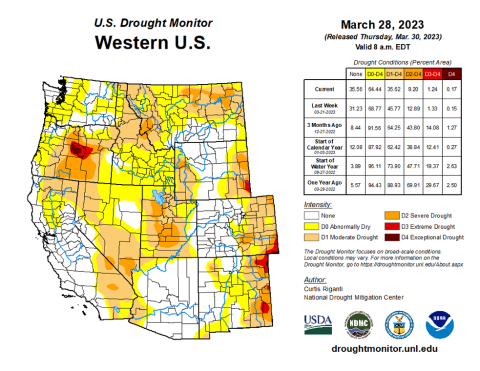
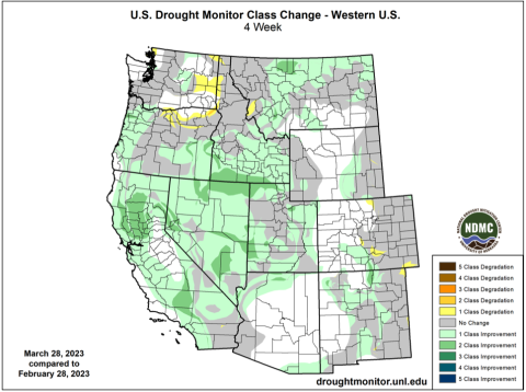
Regional drought conditions improved during March due to above to much-above average precipitation and cool temperatures. At the end of March drought covered 45% of the Intermountain West, down from 55% at the end of February. The most significant improvement in drought conditions occurred in Utah where drought conditions were entirely removed from the eastern, northern, and western portions of the state. Moderate and severe drought conditions remain present in the central portion of Utah. Drought conditions in Colorado and Wyoming changed little during March with drought conditions in the eastern portions of both states and wetter conditions in western Colorado and central Wyoming.
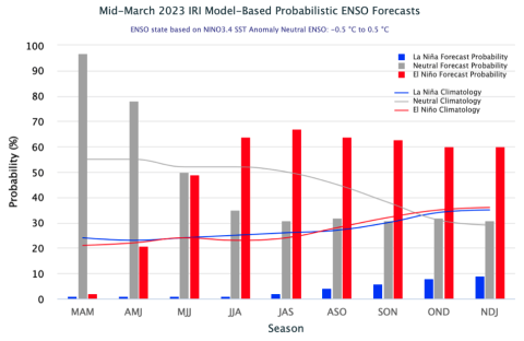
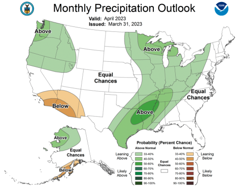
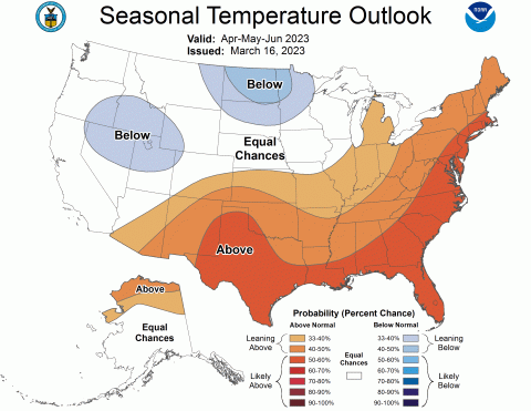
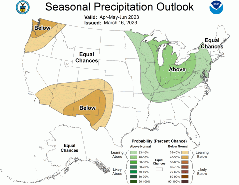
Eastern Pacific Ocean temperatures were slightly below to slightly above average during March leading to neutral ENSO conditions. There is a 60-70% probability of El Niño conditions developing during late summer and persisting through the end of the forecast period in early winter. NOAA seasonal forecasts for April suggest an increased probability of below average temperatures for most of the region and an increased probability of above average precipitation for northwestern Utah. The April-June NOAA seasonal forecast predicts an increased probability for below average precipitation in southern Colorado and southern Utah, an increased probability of below average temperatures for northern Utah, and above average temperatures for southeastern Colorado.
Significant March weather event: Record Utah snowpack. As a scientist, skier, and general lover of snow, I’ve simply run out of superlatives to describe the 2023 winter in Utah. Snowfall and SWE records around Utah are falling, especially in northern Utah. As of April 5th, statewide average SWE is 29.5” and at 209% of normal. The early 1980s, particularly 1983, were the winters of record in Utah, and 2023 has eclipsed nearly all snowfall and SWE records from those years. As of April 4th, of SNOTEL sites with at least 20 years of data, 36 sites were reporting record-high daily SWE totals, and 17 sites reported second-highest daily SWE totals. Twenty SNOTEL sites were reporting all-time record high SWE including Ben Lomond Peak, a site in northern Utah with an astounding 81.8” of SWE and a snow depth of 186”. While I don’t typically report snowfall from ski areas, the snowfall totals in the Wasatch Mountains, particularly the Cottonwood Canyons, are absurdly high. Ski areas in northern Utah have relatively long snowfall records, as long or longer than the SNOTEL network and all have broken all-time snowfall records; current (4/5/23) 2023 record snowfall totals in the Cottonwood Canyons include 874” at Alta, 850” at Brighton, 805” at Snowbird, and 779” at Solitude. Maximum snow depths in the Wasatch Mountains range from 150-250”. Many high elevation sites in Utah have likely not yet reached peak SWE and high elevation snowpack may continue to build. The 2023 winter has also been remarkable due to cold temperatures and very deep snowpacks at low elevations, which the SNOTEL network does not effectively capture. In Salt Lake City, winter 2022-2023 was the 6th snowiest on record (through 4/4) and the snowiest since 1993 with 87” of snowfall since October 1, 2022.
