April 7, 2022 - CO, UT, WY
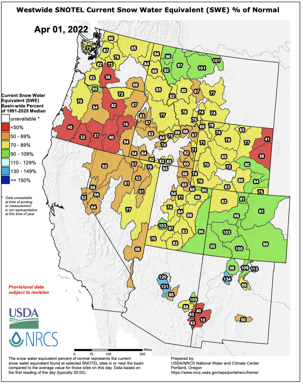
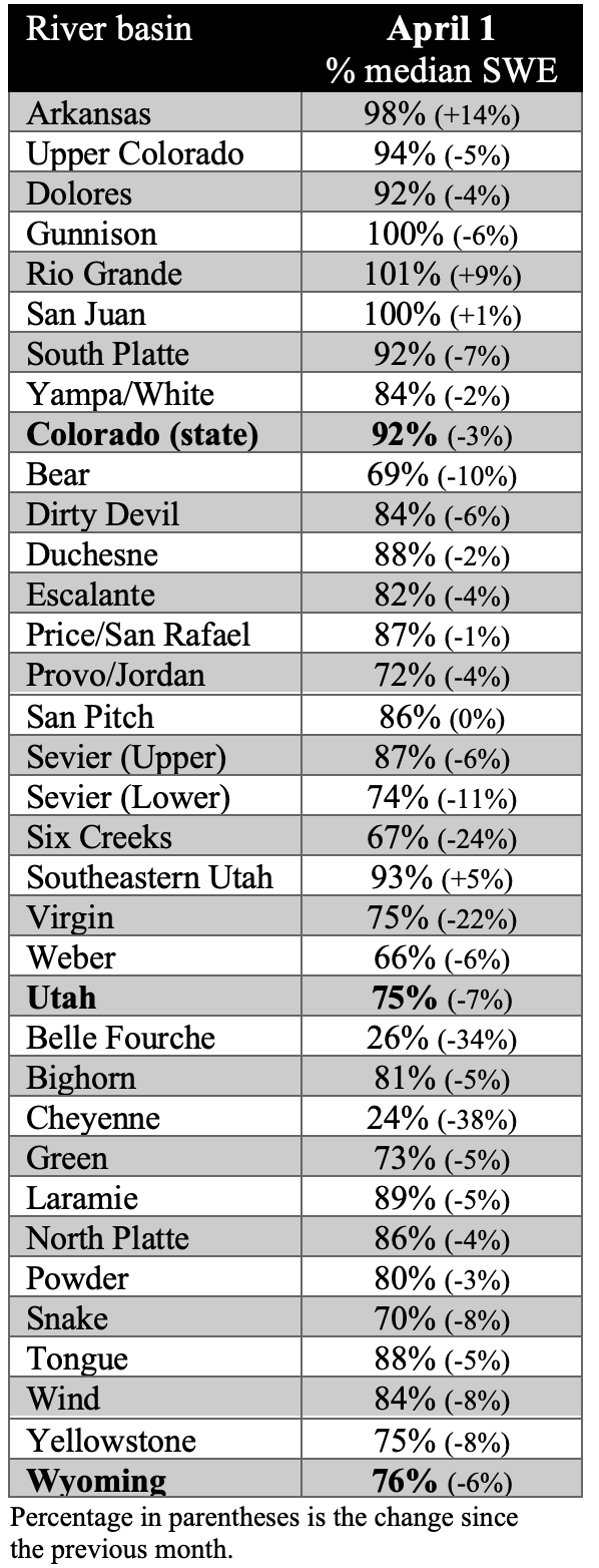
Despite a cooler than normal March, a late-month heat wave triggered snowmelt and an increase in streamflow for most regional river basins. April 1st snowpack was much below normal in Utah (75%) and Wyoming (76%) and near-normal in most Colorado river basins (92%). Below normal precipitation since January 1st was the major cause of low snowpack in Utah and Wyoming. Seasonal streamflow supply forecasts are generally below to much-below normal and Lake Powell inflow is forecasted at 64% of average.
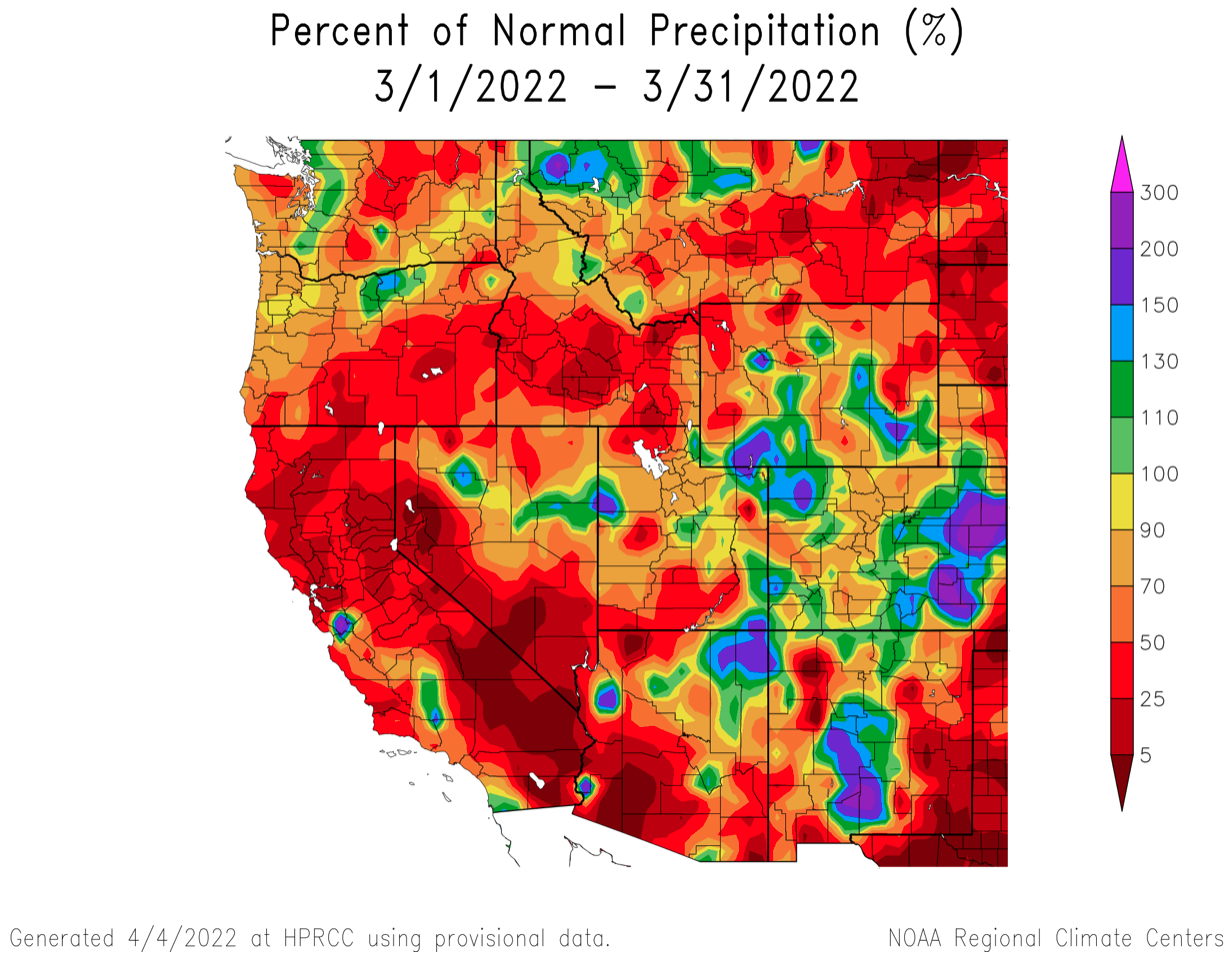
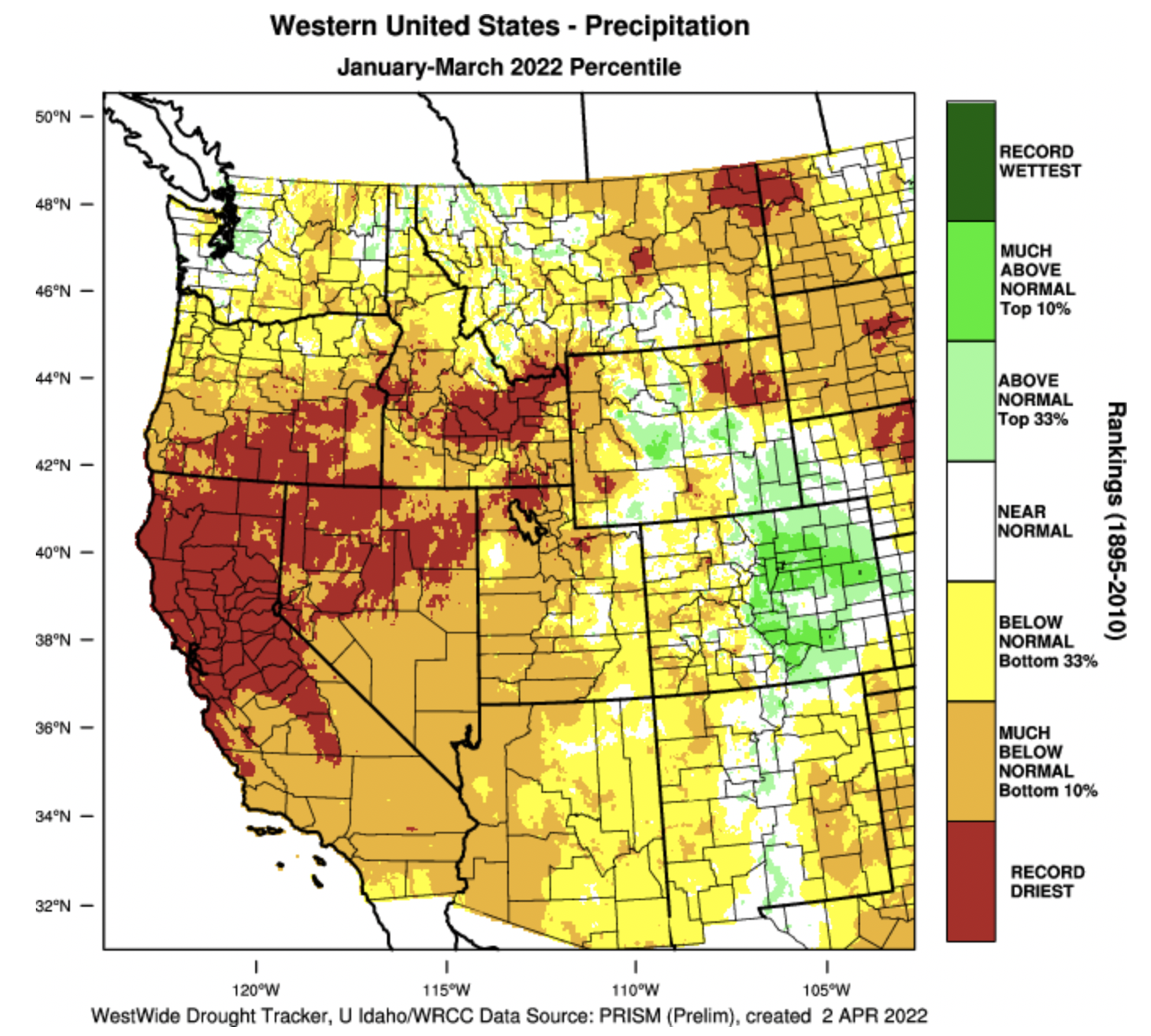
Regional precipitation was generally below normal during March. In Colorado, precipitation was 50-90% of normal in western Colorado and above normal on the Eastern Plains and in parts of the Front Range. Utah precipitation was less than 50% of normal in the south and 70-90% of normal in northern Utah. Wyoming saw above normal precipitation in the central portion of the state and below normal precipitation elsewhere. Locations west of the Continental Divide received below normal precipitation during the last three months with large areas of Utah, western Colorado and western Wyoming seeing precipitations totals among the 12 driest years on record. January-March was the driest on record for parts of northern Utah and Wyoming.
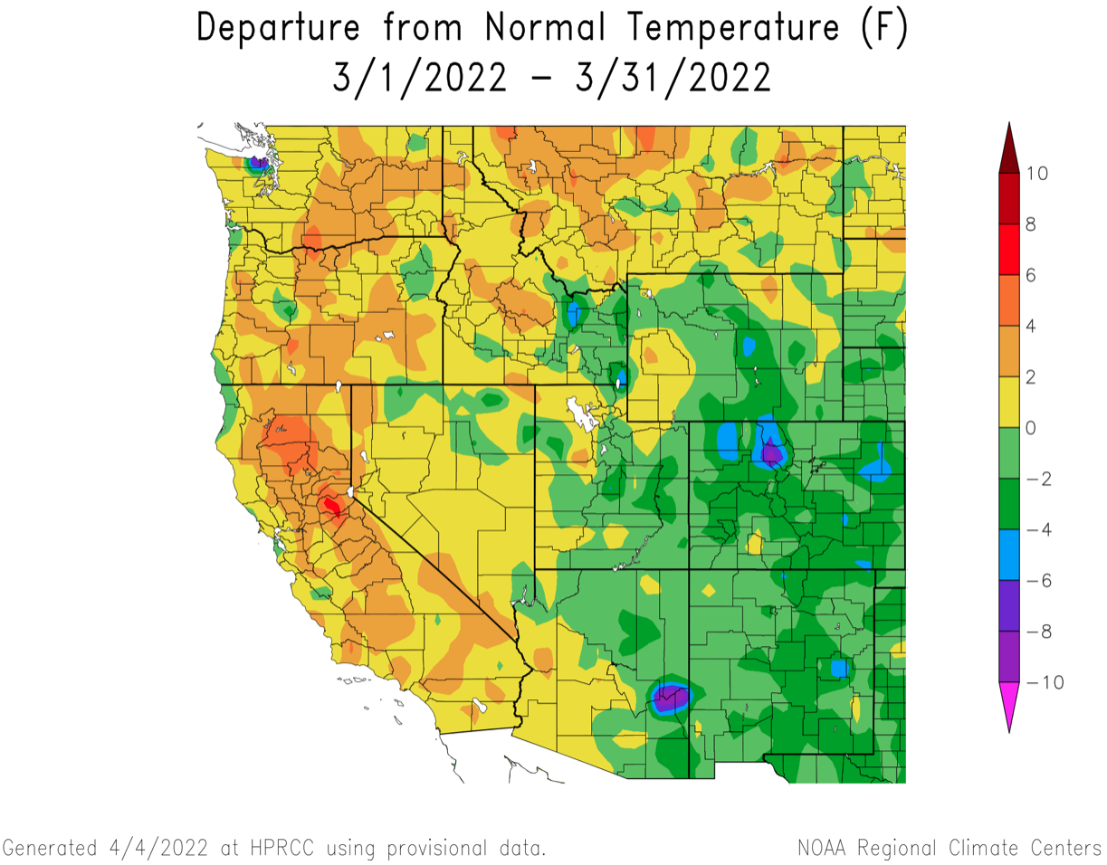
Temperatures were slightly below normal during March. In parts of central Wyoming and eastern Colorado, temperatures were 2-4ºF below normal. Below normal March temperatures were despite an extremely warm last 10 days of March when temperatures were 9-12ºF above average in northern Utah and southwestern Wyoming.
Regional snowpack conditions are a mix of near-normal and below normal as of April 1st. In Colorado, April 1stsnowpack is near-normal except in the Yampa/White River Basins where SWE is 83% of normal. In Utah, April 1st SWE is below normal except for the Beaver River basin and in eastern Utah. Snowpack is 70-90% in most Utah river basins, but 50-70% of normal in the Bear and Weber River basins. In most Wyoming river basins, April 1st snowpack is 70-90% of normal. Near-normal SWE conditions exist in the Laramie River basin and snowpack is less than 40% of normal in northeastern Wyoming. Record warm temperatures in late March caused melt to begin in nearly all regional river basins.
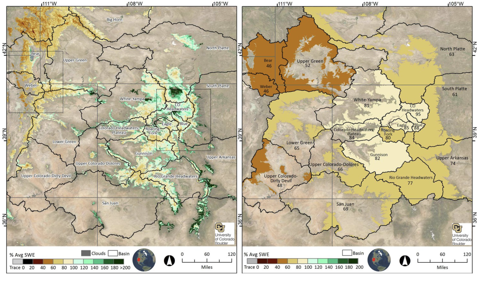
The University of Colorado Mountain Hydrology Group is issuing reports containing near-real-time estimates of snow-water equivalent (SWE) for the Intermountain West region (Colorado, Utah and Wyoming). Modeled SWE output is generated as an experimental research product at a spatial resolution of 500 m from mid-winter through the melt season. The report is typically released within a week of the date of data acquisition at the top of the report. Detailed SWE maps (in JPG format) and summaries of SWE (in Excel format) by individual basin and elevation band accompany the report and are publicly available on their website.
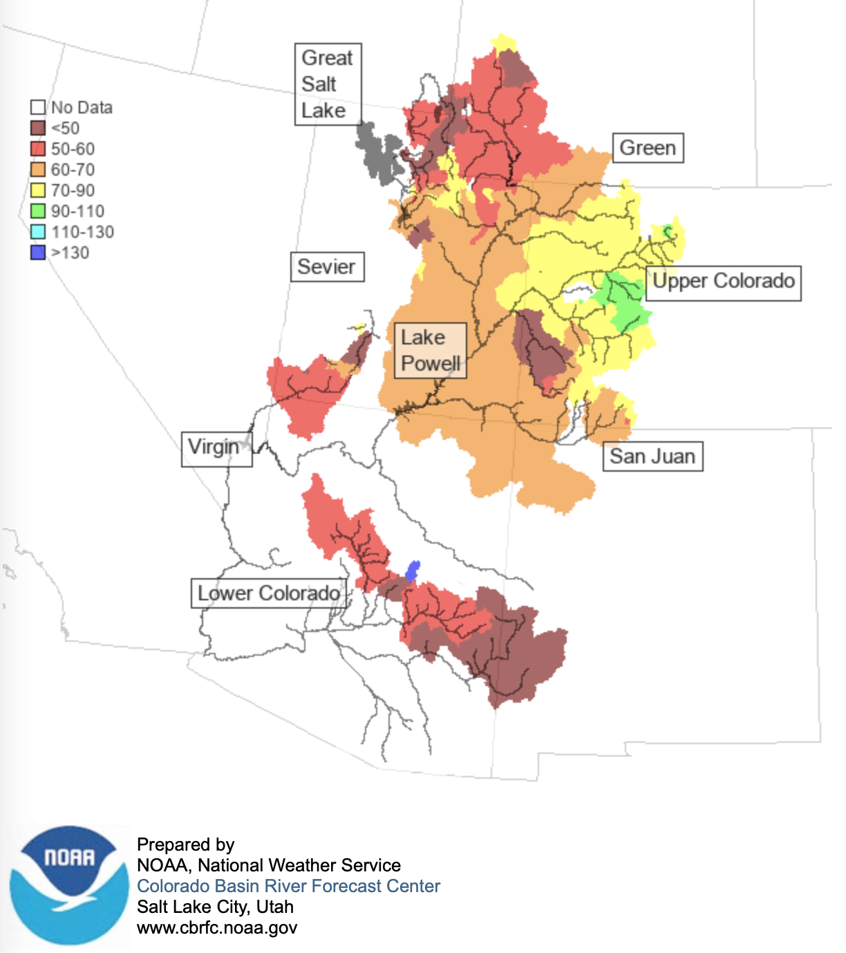
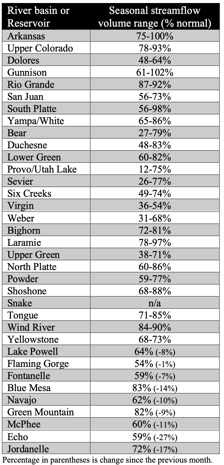
Seasonal streamflow volume forecasts for April 1st are below normal throughout the region except for parts of the Arkansas, Gunnison and Laramie River basins where streamflow volume forecasts are near-normal. Seasonal streamflow forecasts in the Upper Colorado River basin range from 40-100% of normal and 30-80% of normal in the Great Basin. Seasonal streamflow forecasts declined slightly since March 1st due to below average March precipitation. A late March heat wave caused snowmelt to begin and streamflow increased to above average flows by the end of March.
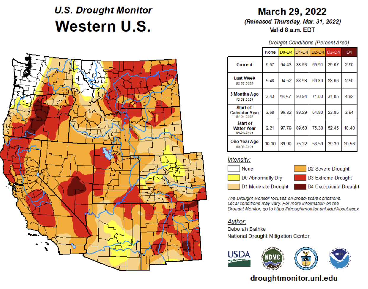
Drought conditions remain in place across 93% of the region. Parts of northern and western Colorado are the wettest, but are still experiencing abnormally dry conditions. Extreme (D3) drought covers 20% of the region. Extreme drought conditions developed in northwestern Wyoming and along the Wasatch Front during March. Extreme drought conditions impacted regional rivers during March. Record low March streamflow was observed at sites along the American Fork, Dolores, East Fork of the Sevier, San Juan, San Rafael and Weber Rivers in Utah, the Animas and Dolores Rivers in Colorado and the Firehole and Snake Rivers in Wyoming.
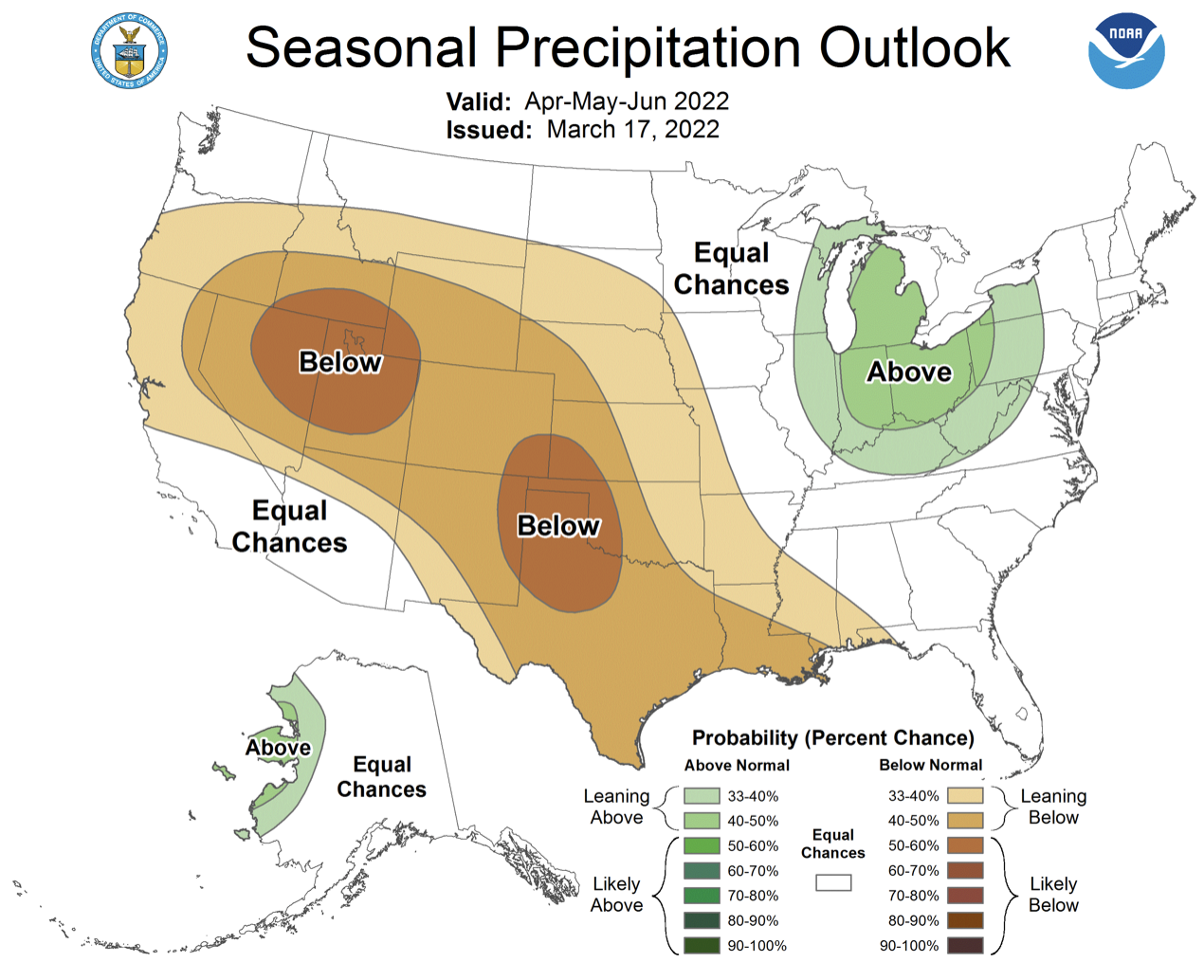
La Niña conditions remain in place over the eastern Pacific Ocean, but the majority of ocean temperature models project a return to neutral ENSO conditions by summer. There is an increased probability for below average precipitation and above average temperatures during April for Colorado and Utah. During April-June, there is an increased probability for below average precipitation for the entire region, but Utah has a greater than 60% probability for below average precipitation. There is also an increased probability for above average temperatures during April-June across Colorado, Utah and Wyoming, with the highest probability in southern Colorado.

Significant March weather event: Regional heat wave. A regional heat wave, centered over Utah, set daily maximum temperature records and triggered early snowmelt from March 24-29. In Utah, 20-45% of sites with at least 50 years of data observed daily maximum temperatures records on 3/25-3/27. Notable daily high temperature records include the first days over 80ºF during March in Tooele, UT and the hottest March temperature recorded in Ogden (79ºF) and Morgan, UT (77ºF). Daily high temperature records were observed at sites in western and southern Wyoming on 3/26-27 with all-time March high temperatures recorded in Green River, Moose and Wamsutter. In Colorado, fewer maximum daily temperature records were set, but 20-25% of sites with greater than 50 years of observations set daily records on 3/26-27. The temperature record at snotel sites is shorter (10-40 years), but many daily high temperature records were observed. On 3/25, 98 of 106 snotel sites in Utah observed a new daily high temperature record and on 3/27 72 of 114 snotel sites in Colorado recorded new daily high temperature extremes. The cumulative result of the heat wave was the onset of snowmelt in nearly all regional river basins.
