November 10, 2026 - CO, UT, WY
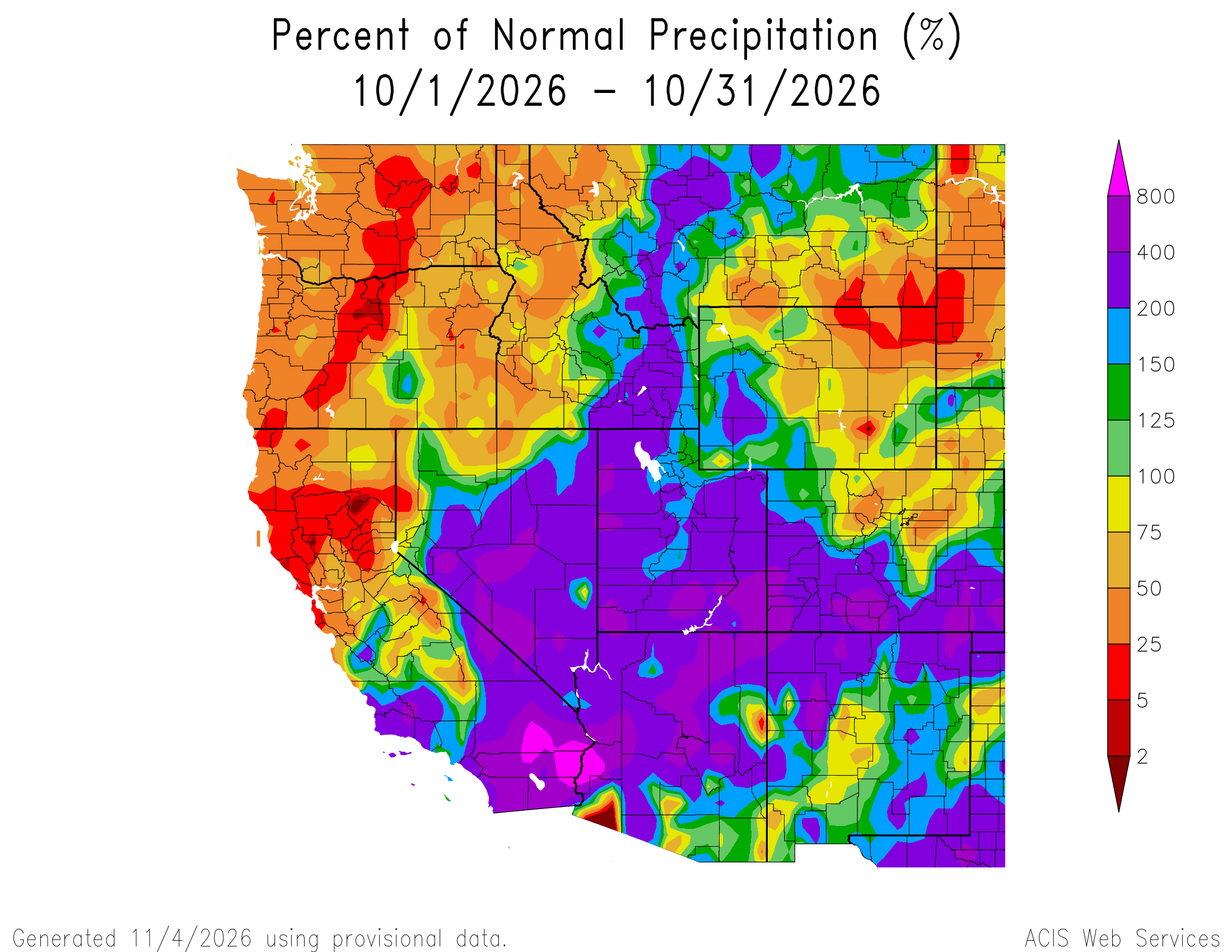
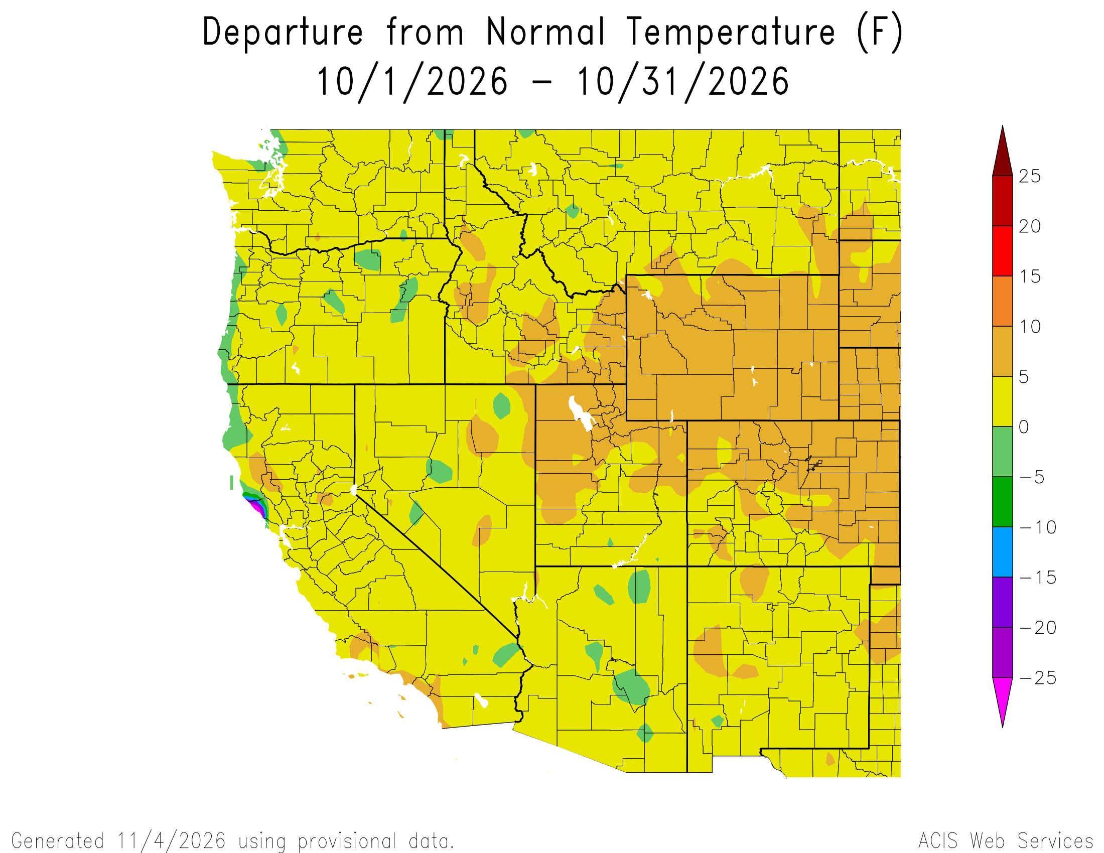
Above average precipitation continued during October, with large areas in southern Utah and southern Colorado receiving 400-800% of average precipitation. October temperatures were at least 5°F above average across the region, with up to 10°F above average temperatures in Wyoming, northern Utah, and northern and eastern Colorado. November 1 snow-water equivalent (SWE) was much above normal in much of Utah and southwestern Colorado, and much below normal in Wyoming and northern Colorado. Regional drought extent decreased from 90% coverage of Colorado, Utah, and Wyoming at the end of September to 60% coverage by November 3. Very strong El Niño conditions persist in the eastern Pacific Ocean, with weekly sea surface temperature anomalies running 3.4ºC above average in the Niño-3.4 index during the week of October 28. NOAA seasonal forecasts for precipitation suggest an increased probability of above average precipitation from November–January for southern and eastern Colorado, and below average precipitation for northwestern Wyoming.
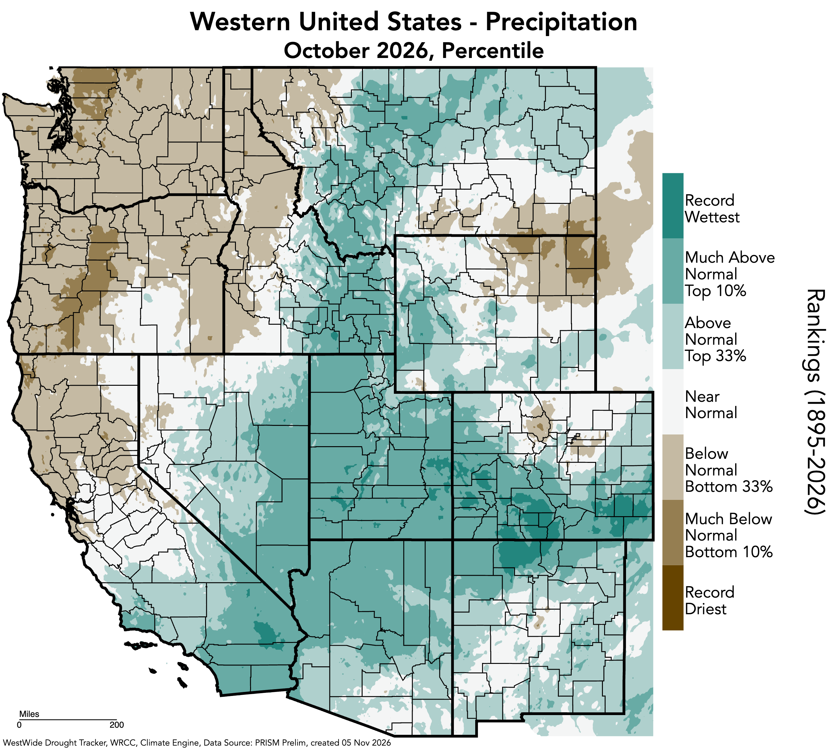
October precipitation varied across the region, from above average conditions in Utah, southern Colorado, and southwestern Wyoming, to below average conditions in northern Colorado and eastern Wyoming. Much of Utah and southern Colorado experienced 200-400% of average precipitation, with large areas in southern Utah and southern Colorado receiving 400-800% of average precipitation. Significant rainfall throughout October resulted from repeated surges of tropical moisture mixing with strong upper-level low-pressure systems. These meteorological conditions caused two significant flooding events in the Four Corners region, particularly in Pagosa Springs and South Fork in southwestern Colorado and Hurricane and Bluff in southwestern Utah. Much of southern Colorado and pockets of southern Utah experienced record-wet conditions in October. Meanwhile, Colorado’s Front Range and northern mountains experienced 50-75% of average precipitation, with areas of 25-50% of average precipitation. Unlike Utah and much of Colorado, Wyoming generally experienced below average conditions, with 5-50% of average precipitation in northeastern Wyoming.
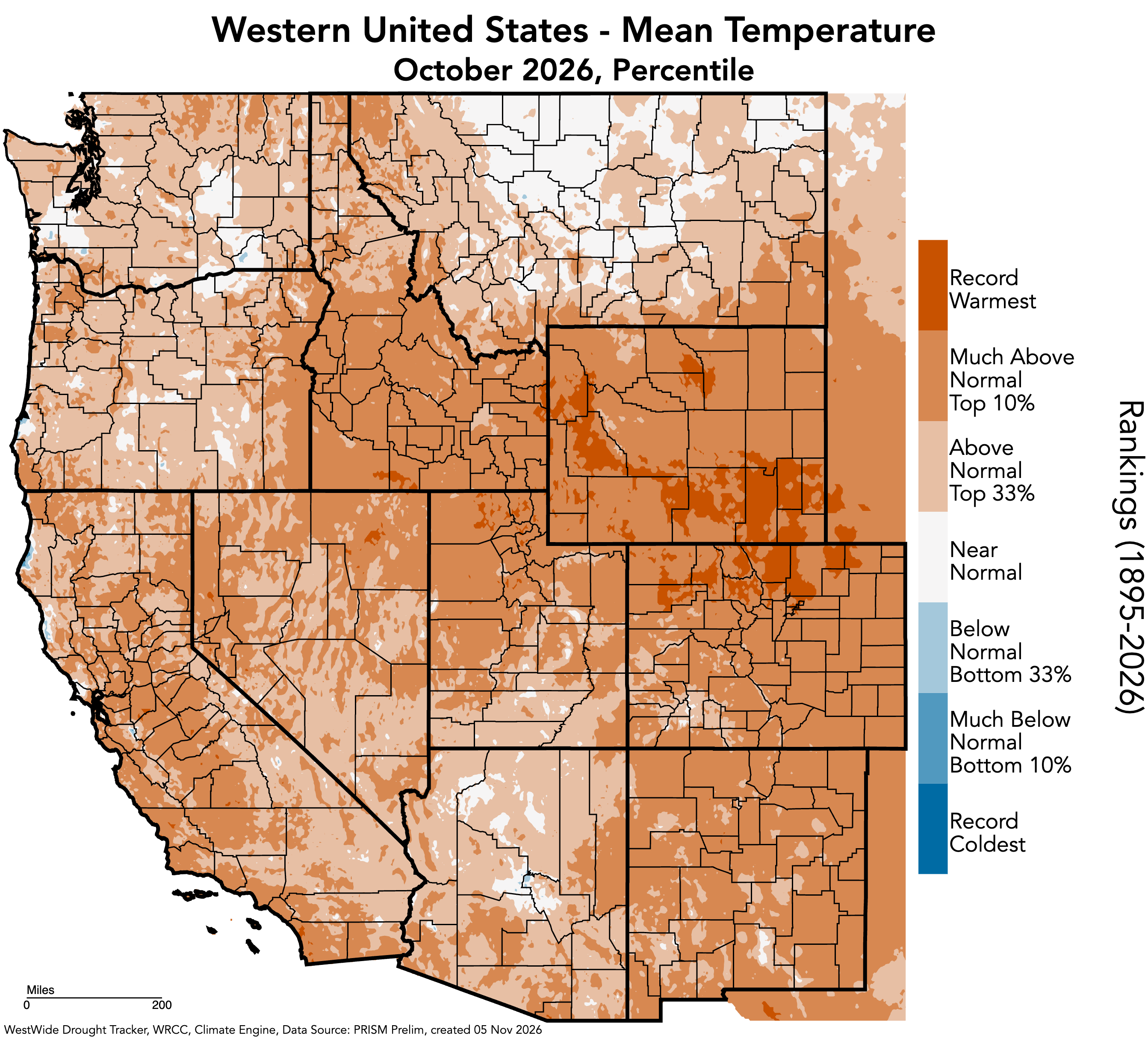
The region experienced near-to-above average temperatures in October. Southern Utah and southwestern Colorado experienced up to 5°F above average temperatures, while 5-10°F above average temperatures occurred in Wyoming, northern Utah, and northern and eastern Colorado. Much of northern Colorado and southern Wyoming experienced record-warm temperatures in October, with pockets of record-warm temperatures in western and northern Wyoming and northern Utah.
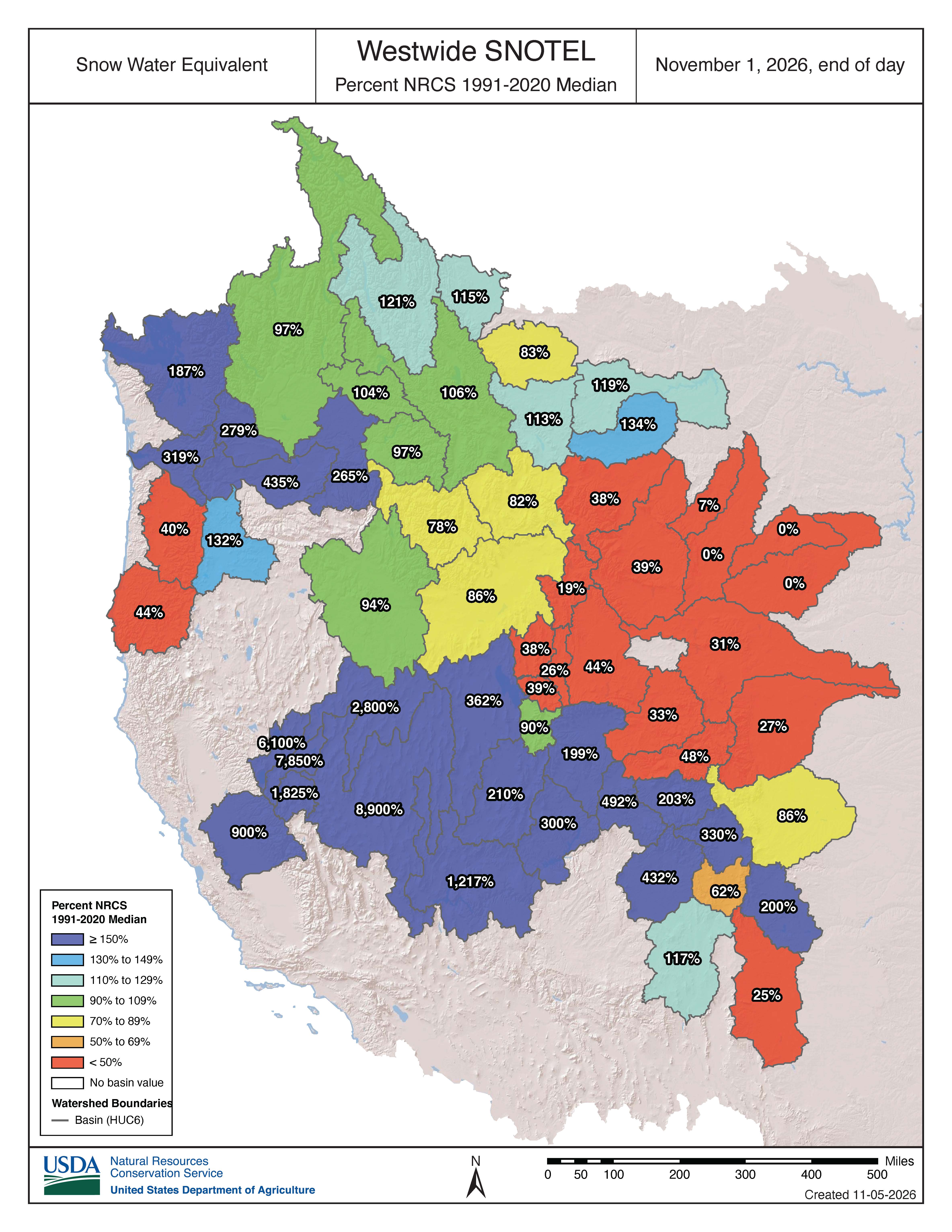
As of November 1, SWE was highly variable across the region, from much above normal SWE in Utah and southwestern Colorado, to much below normal SWE in Wyoming and northern Colorado. SWE was as high as 1,217% of normal in the Lower Colorado-Lake Mead basin to as low as 0% of normal in northeastern Wyoming. SWE was much above normal in many other basins, including the Upper Colorado-Dolores (492%), Upper San Juan (432%), Rio Grande Headwaters (330%), and Gunnison (203%) basins in Colorado, and the Great Salt Lake (362%), Upper Colorado-Dirty Devil (300%), Escalante Desert-Sevier Lake (210%), and Lower Green (199%) basins in Utah. On November 1, statewide SWE levels were 0.6 inches in Colorado, 0.2 inches in Utah, and 0.3 inches in Wyoming. October storms were relatively warm, and regional snowpack is not yet present below 8,500 feet.
Note: Current SWE as a percent of normal maps are often skewed at this time of year due to the very low average SWE this early in the season.
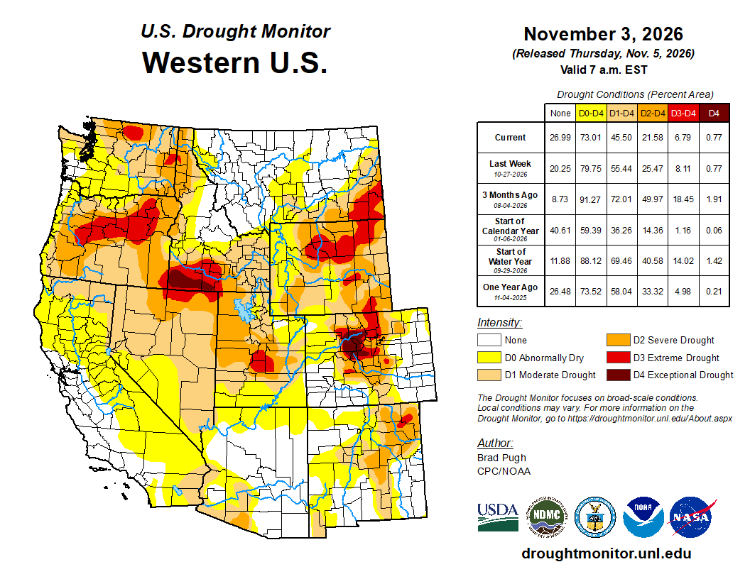
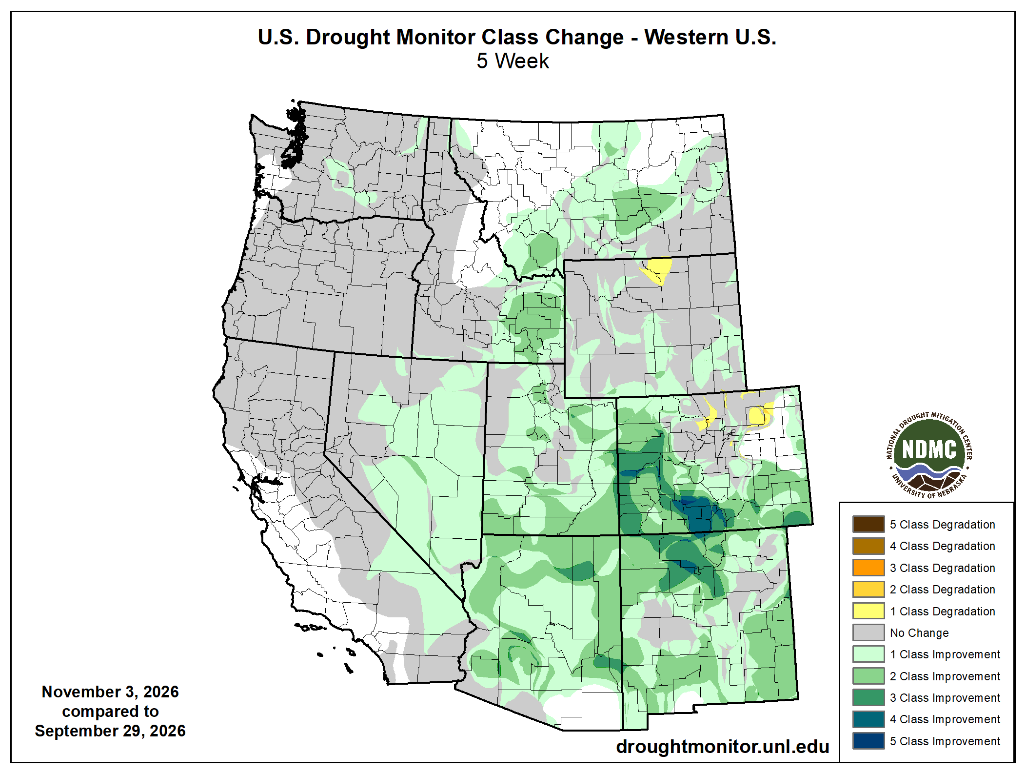
Regional drought extent decreased significantly from 90% coverage of Colorado, Utah, and Wyoming at the end of September to 60% coverage by November 3. This was largely due to the tropical moisture surges that caused significant rainfall in Utah and southern and western Colorado throughout October. Moderate (D1) drought conditions improved by 43% in Colorado, 34% in Utah, and 12% in Wyoming. Coverage of extreme (D3) and exceptional (D4) drought conditions also decreased across all three states during October. D3 drought conditions improved by 24% in Colorado, 21% in Utah, and 4% in Wyoming, and D4 drought conditions improved by 6% in Colorado.
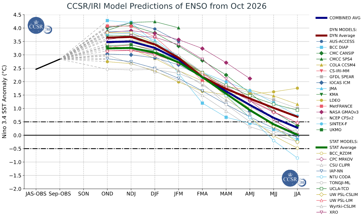
Very strong El Niño conditions persist in the eastern Pacific Ocean, with weekly sea surface temperature anomalies running 3.4ºC above average in the Niño-3.4 index during the week of October 28. Three-month sea surface temperature anomalies are running 2.46°C above average in the Niño-3.4 index for August–October. There is a greater than 80% probability of a very strong El Niño event through winter 2026-27. There is a 100% probability of El Niño conditions continuing at least through March–May 2027.
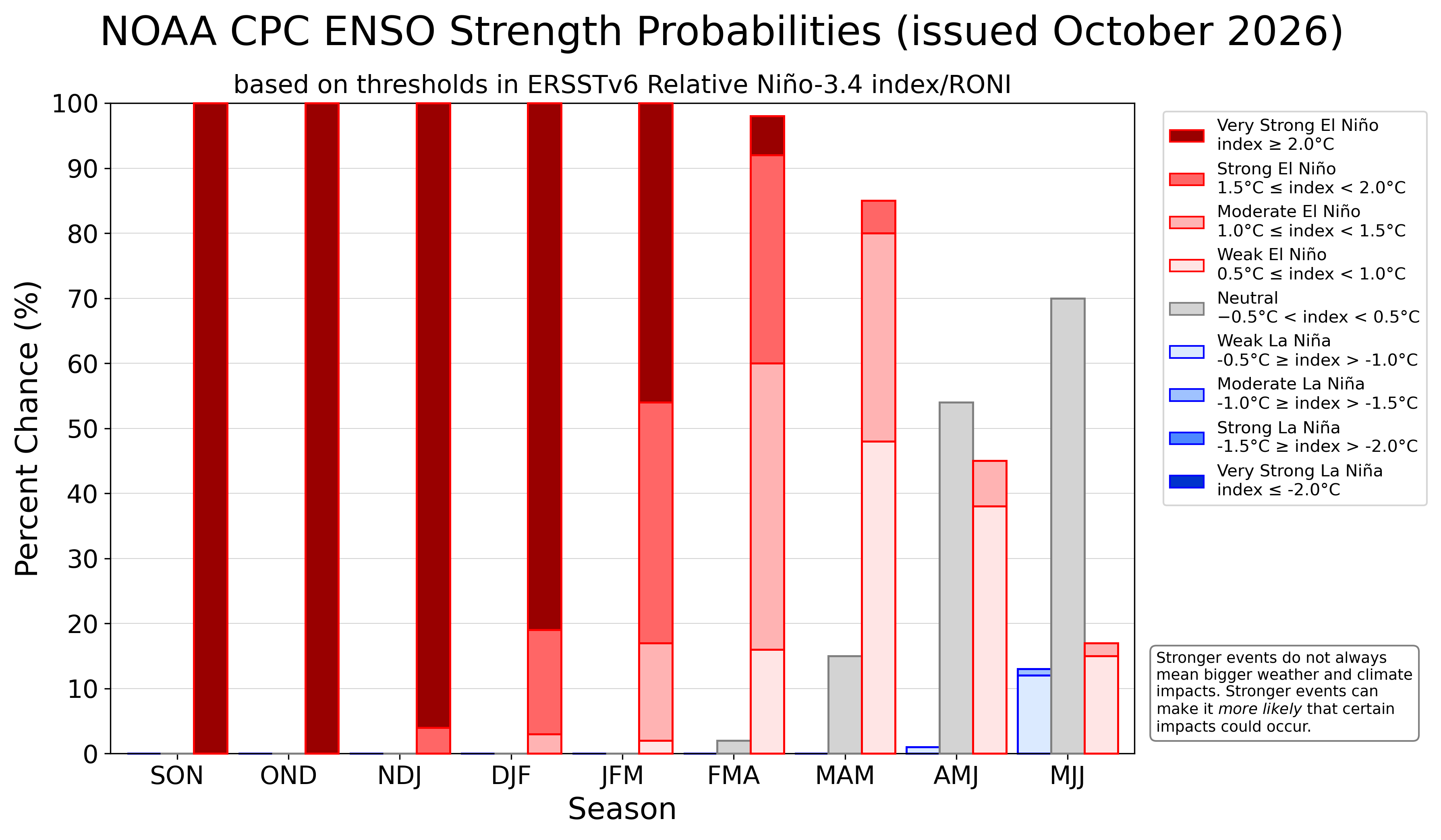
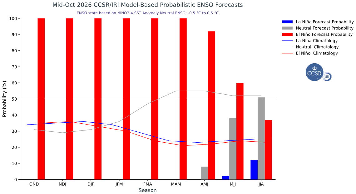
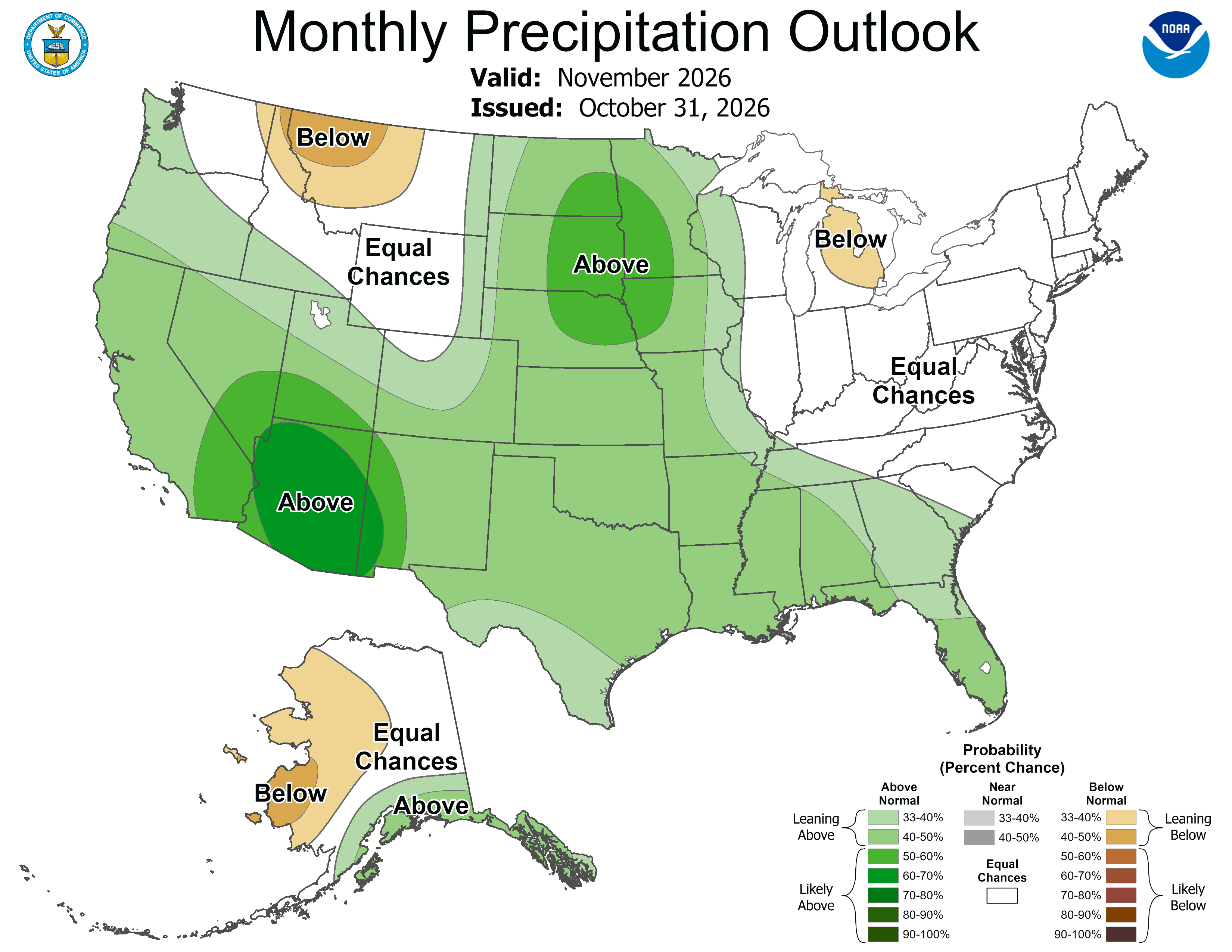
Seasonal forecasts for precipitation and temperature in 2026-2027 are strongly influenced by the current very strong El Niño conditions. NOAA seasonal forecasts for precipitation suggest an increased probability of above average precipitation in November for Colorado and Utah, and an increased probability of above average precipitation from November–January for southern and eastern Colorado, and below average precipitation for northwestern Wyoming. NOAA seasonal forecasts indicate an increased probability of above average temperatures in November for the region and from November–January for western and northern Utah and Wyoming.
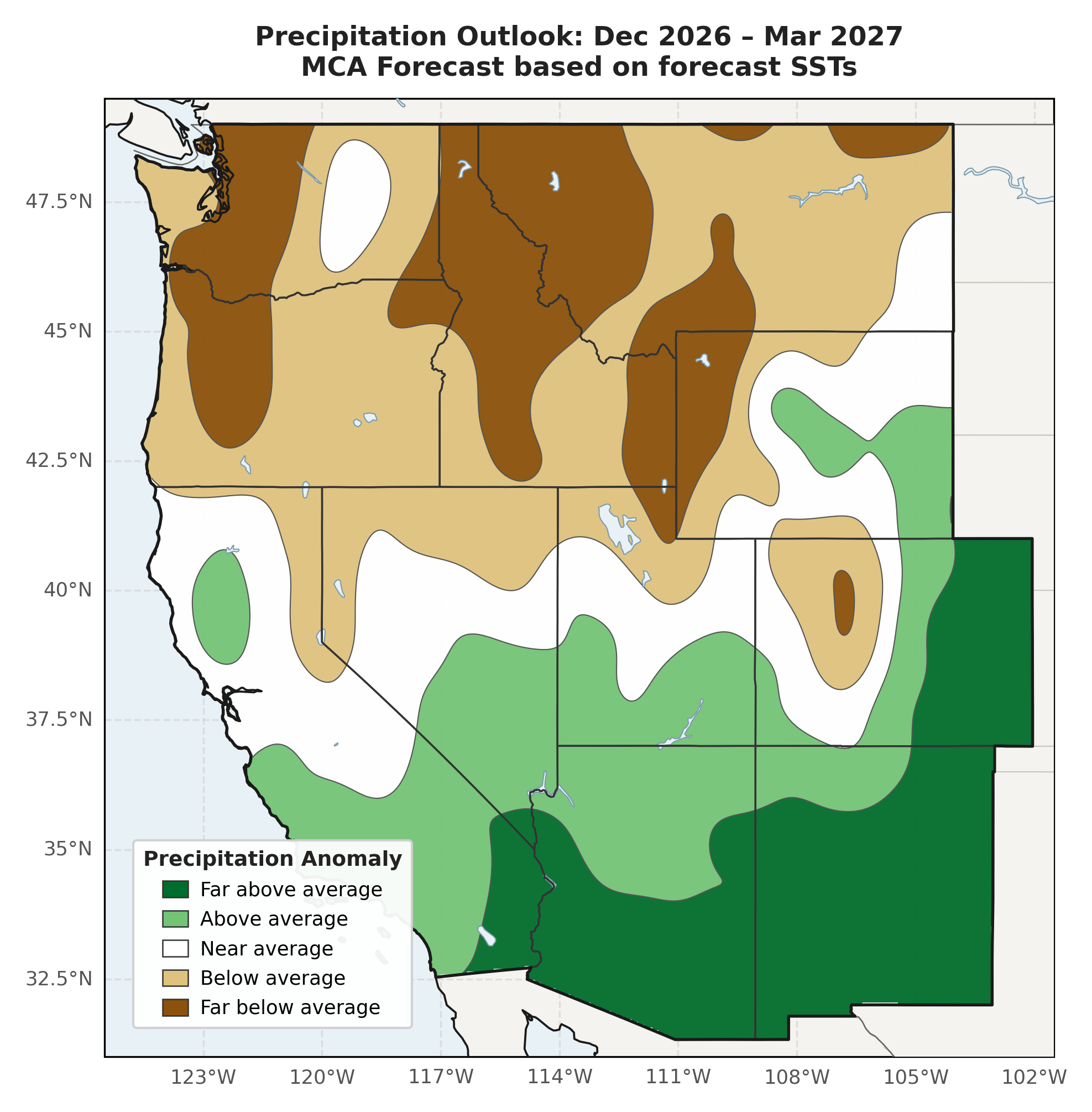
WWA's Winter Precipitation Forecast, which uses both Pacific and Atlantic Ocean temperatures to forecast December–March precipitation, suggests below average winter precipitation in western Colorado, northern Utah, and western Wyoming, and above average winter precipitation in eastern Colorado, southern Utah, and southeastern Wyoming.


Significant weather event: Pagosa Springs flooding. From October 21–25, increased tropical moisture in the eastern Pacific Ocean and remnants from Hurricane Trudy coupled with a strong trough of low pressure off the West Coast led to heavy rainfall events across southwestern Colorado, from Durango to the San Luis Valley, as well as neighboring regions of Utah, New Mexico, and Arizona. On October 23, the San Juan River running through Pagosa Springs reached a peak of 15.02 feet, surpassing the peak crest of 12.82 feet from last October’s flooding event in Pagosa Springs. All the rivers in and near Pagosa Springs, including the San Juan, Piedra, Rio Blanco, and Navajo, all overflowed their banks, prompting mandatory evacuations and causing significant flooding in the town and the region, resulting in flooded homes, businesses, and infrastructure, and closed mountain passes and washed out roads. The flooding caused an estimated $38 million in damage within Pagosa Springs town limits.
From October 31–November 2, an atmospheric river transported abundant moisture into the Four Corners region, causing heavy rainfall and another historic flooding event in Pagosa Springs and the region. Officials in Pagosa Springs issued mandatory evacuations on October 31, warning of ‘catastrophic flooding’ as the San Juan River was forecasted to crest at 20 feet or more the night of November 1. This event ended up surpassing the October 23 peak crest on the San Juan River by almost 2 feet, cresting at 16.81 feet on November 2, only second to the 1911 flood in Pagosa Springs which peaked at 17.8 feet on the river. Many homes, businesses, roads, culverts, and other infrastructure flooded or washed out, and Pagosa Springs ordered a shelter-in-place as raw sewage discharged directly into the floodwaters, making the water hazardous to come into contact with. Significant parts of the town were damaged, including the main bridge into town on US-160, The Springs Resort, the Pagosa Springs History Museum, and more that affect residents and the town’s economy and culture.