January 13, 2026 - CO, UT, WY
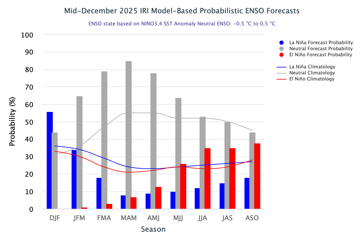
The region experienced record-warm temperatures and below to near average precipitation in December. Below to much below normal snowpack conditions exist throughout Colorado, Utah, and eastern Wyoming, with the exception of above normal snowpack in western Wyoming. The first seasonal streamflow forecasts of the year suggest below average runoff in Colorado, Utah, and southeastern Wyoming river basins. Drought coverage remains at 54% for the region since late December, although snow drought is persisting. La Niña conditions are expected to transition to ENSO-neutral conditions during January-March.
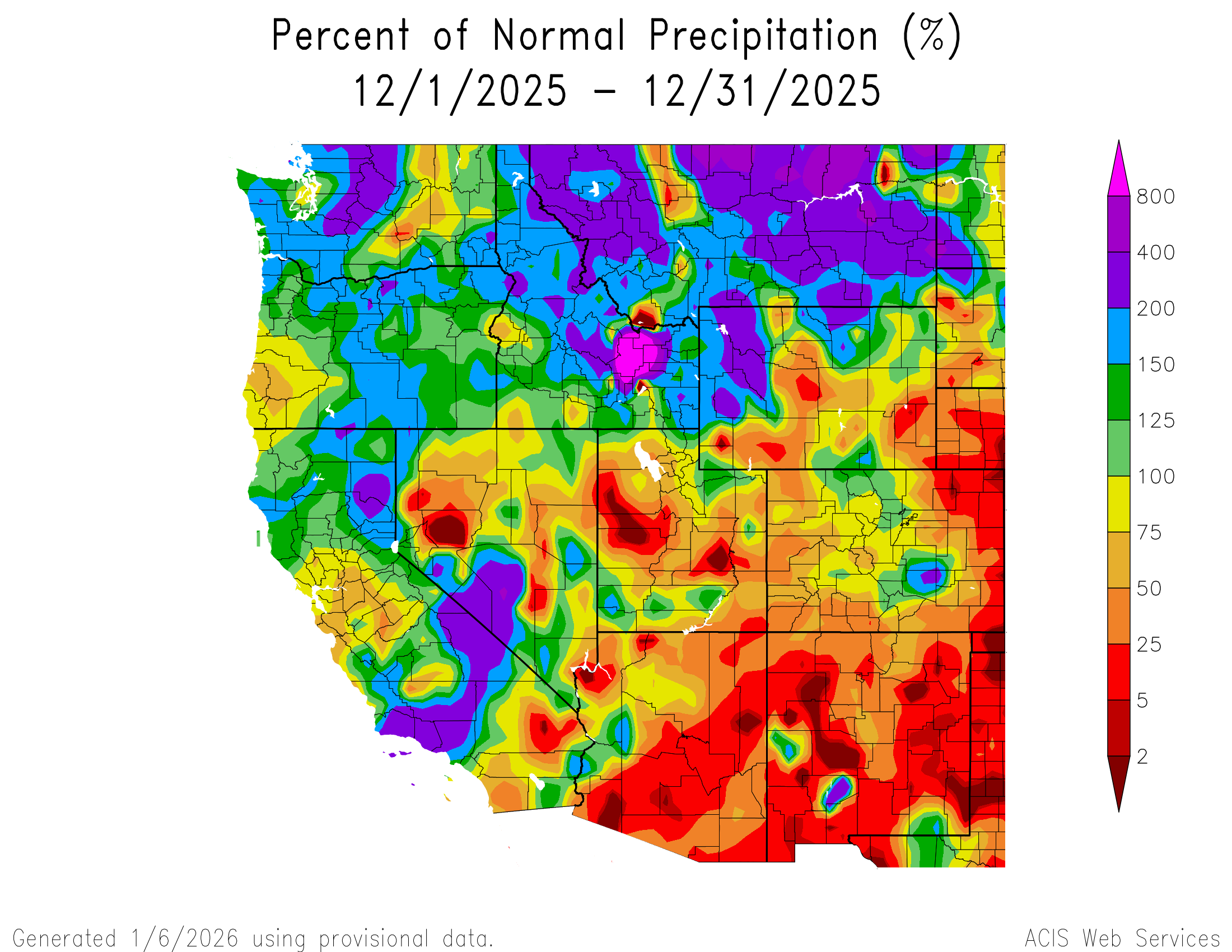
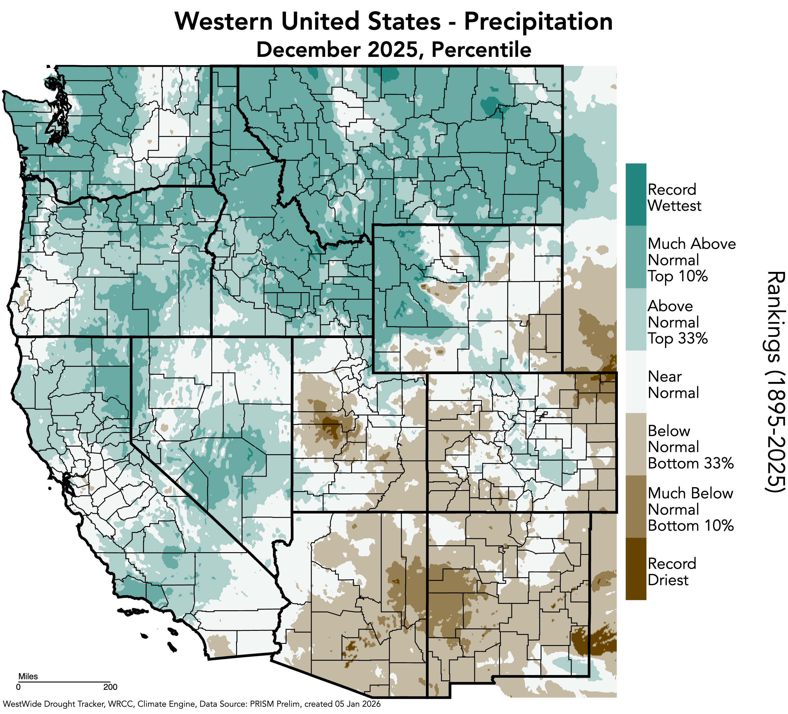
December precipitation was below to near average throughout much of the region, with areas of less than 25% of average conditions in eastern Colorado, western and eastern Utah, and southern Wyoming. Pockets of less than 2% of average precipitation occurred in Tooele, Juab, and Millard Counties in western Utah, and Emery County in eastern Utah. These conditions also occurred in smaller pockets in northeastern and southeastern Colorado, and southwestern Wyoming. In contrast, areas of above average precipitation occurred in each state, particularly in northern and western Wyoming, where large pockets of 200% of average conditions occurred. Record-dry December precipitation occurred in Juab and Millard Counties in Utah, and in Logan, Sedgwick, and Phillips Counties in northeastern Colorado. Record-wet December precipitation occurred in Park, Teton, Hot Springs, Fremont, and Sublette Counties in northwestern Wyoming.
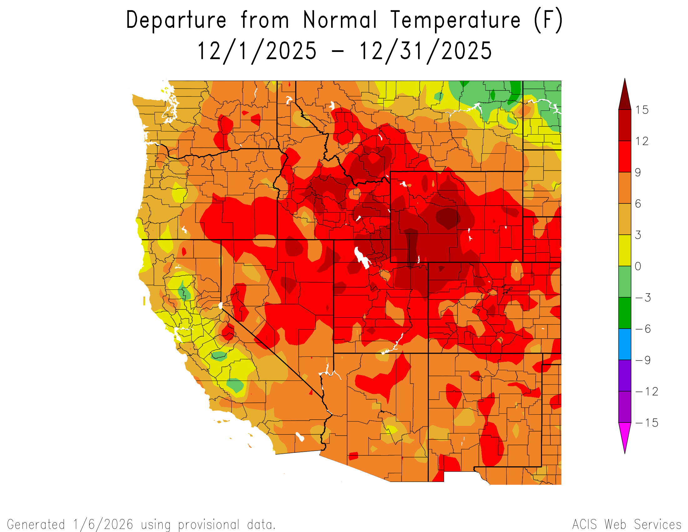
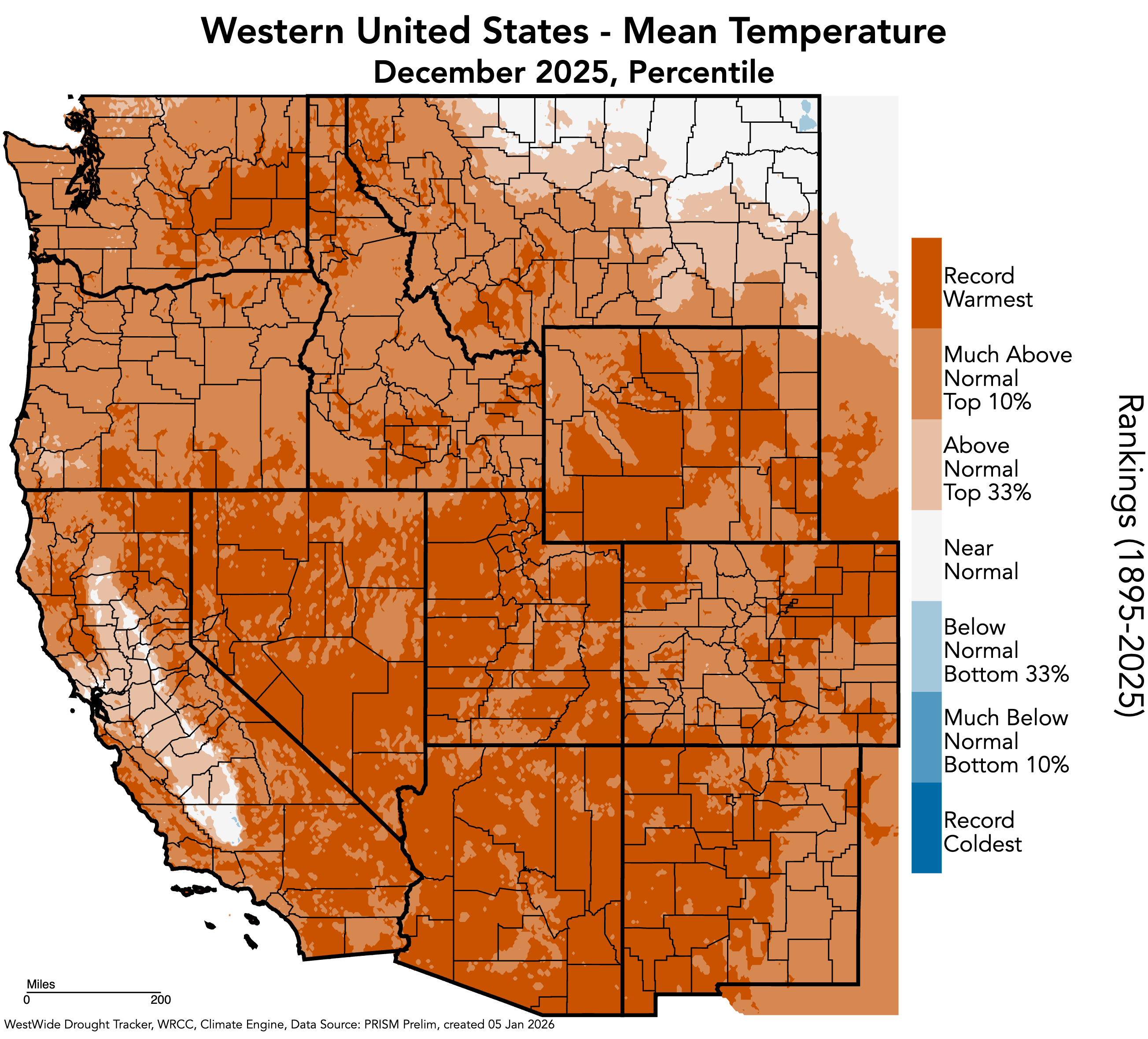
December temperatures were much above average throughout the region. Much of the region saw 9 to 12°F above average temperatures, with a large pocket of 12 to 15°F above average temperatures in western Wyoming, northern Utah, and northwestern Colorado. Pockets of 15°F or more above average temperatures occurred in three areas: one in Fremont and Natrona Counties in western Wyoming, another from southwestern Wyoming to northeastern Utah, and the last in Moffat County in northwestern Colorado. The entire region experienced much above average (top 10%) to record-warm temperatures in December. For weather monitoring sites with at least 50 years of data, 50 of 60 sites in Utah had a record-warm December, 31 of 75 sites had records in Colorado, and 34 of 46 sites had records in Wyoming. All SNOTEL sites except 1 had record-warm Decembers in Utah, all SNOTEL sites but 3 had records in Wyoming, and all SNOTEL sites but 16 had records in Colorado. These records vary from a few years to 47 years. A record-warm October-December was recorded at most regional SNOTEL sites. For example, all SNOTEL sites in Utah, except 3 in southern Utah, had a record-warm October-December.
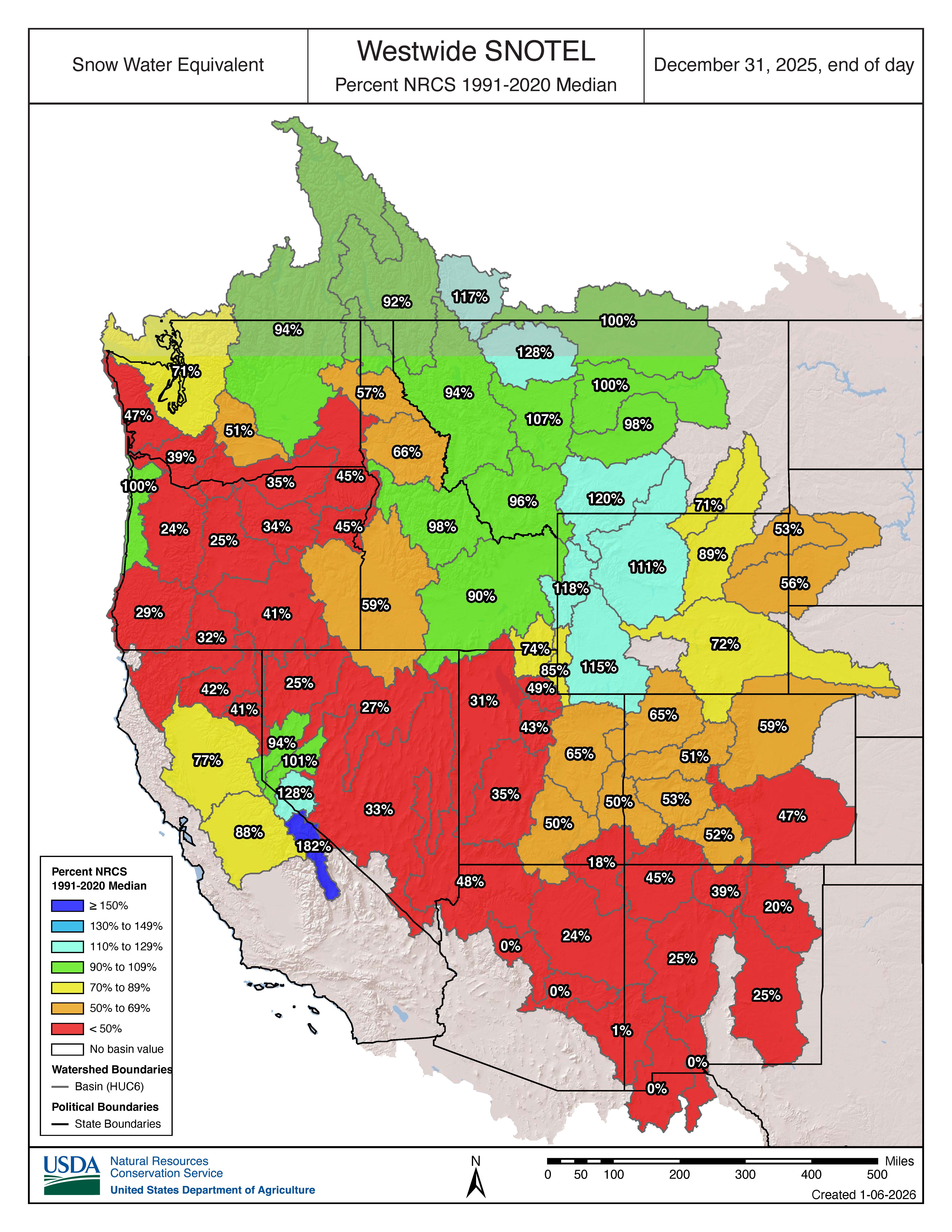
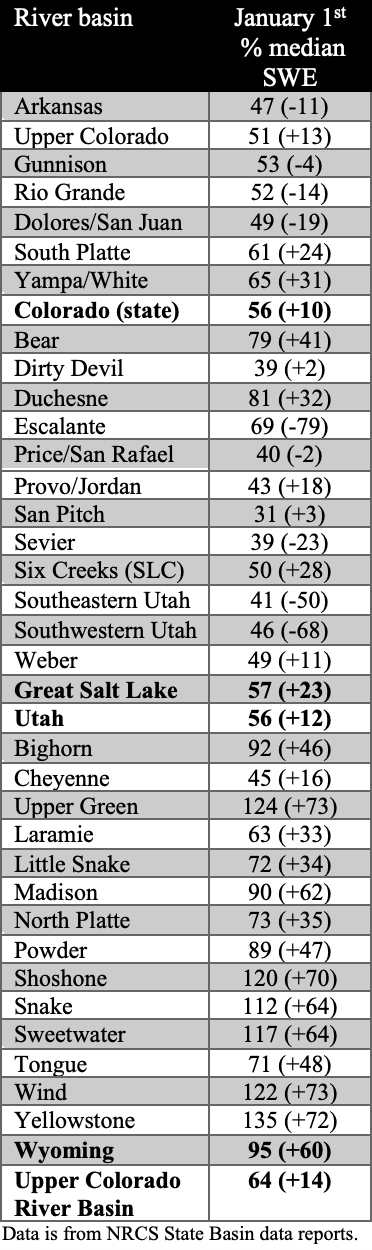
Below to much below normal snow-water equivalent (SWE) continues to exist for Colorado, Utah, and eastern Wyoming as of January 1. River basins with less than 50% of normal SWE include the Upper Arkansas (47%) and Upper San Juan (45%) in Colorado, and the Weber (49%), Lower Colorado-Lake Mead (48%), Jordan (43%), Escalante Desert-Sevier Lake (35%), Great Salt Lake (31%), and Lower San Juan (18%) in Utah. In contrast, western Wyoming river basins have above normal SWE, including the Big Horn (111%), Upper Green (115%), Snake Headwaters (118%), and Upper Yellowstone (120%). Snow drought in the western U.S. continues to persist this winter, and according to NIDIS, over 80% of all Snow Telemetry (SNOTEL) stations in Colorado, Utah, Washington, Oregon, Arizona, and New Mexico are experiencing snow drought.
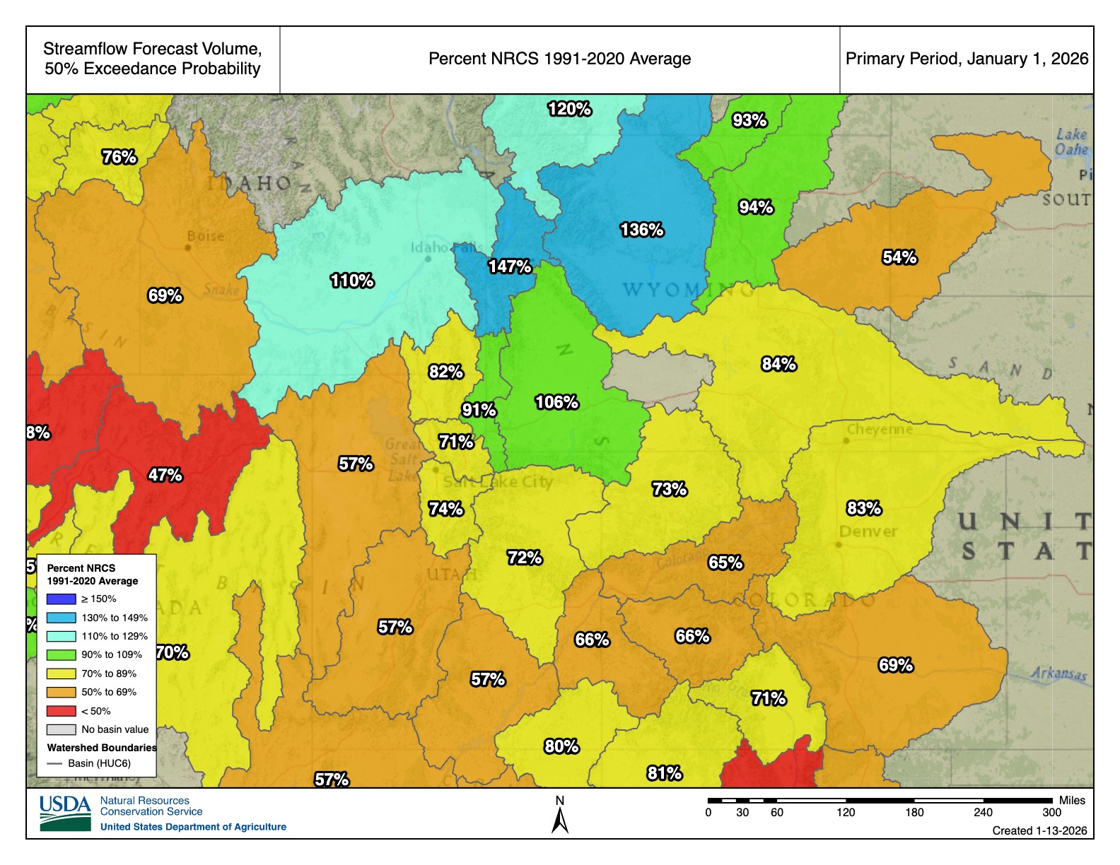
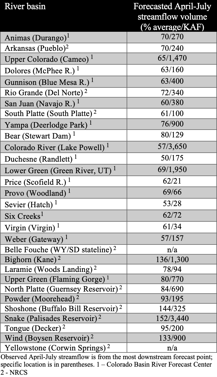
The first seasonal streamflow forecasts of the 2026 water year suggest below average runoff in Colorado, Utah, and southeastern Wyoming river basins, and near to above average runoff in northern and western Wyoming river basins. In Colorado, seasonal streamflow forecasts suggest 65-85% of average runoff for all river basins. Runoff in most Utah river basins is forecasted at 55-80% of average, except for the Upper Bear (91%) and Lower Bear (88%). Wyoming has a mix of streamflow forecasts, with below average forecasts in the Cheyenne (54%) and North Platte (84%) River Basins, near average forecasts in the Tongue (93%), Powder (94%), and Upper Green (106%) River Basins, and above average forecasts in the Upper Yellowstone (120%), Big Horn (136%), and Snake (147%) River Basins. Below average inflow is forecasted for Lake Powell (57%), Flaming Gorge (80%), McPhee (63%), Blue Mesa (63%), and Navajo (60%) Reservoirs. If drought conditions continue in 2026, the water level in Lake Powell is at risk of dropping below minimum power pool (3,490 feet above sea level), which will threaten dam infrastructure and halt hydropower generation at Glen Canyon Dam.
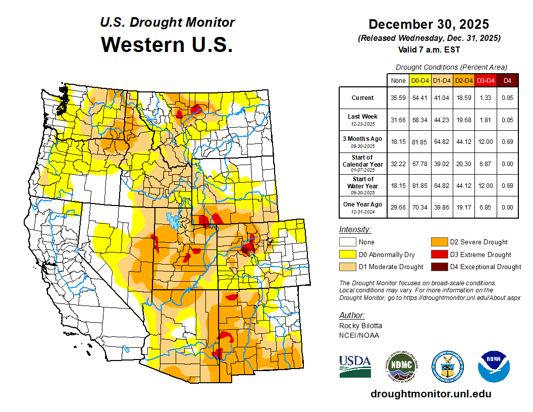
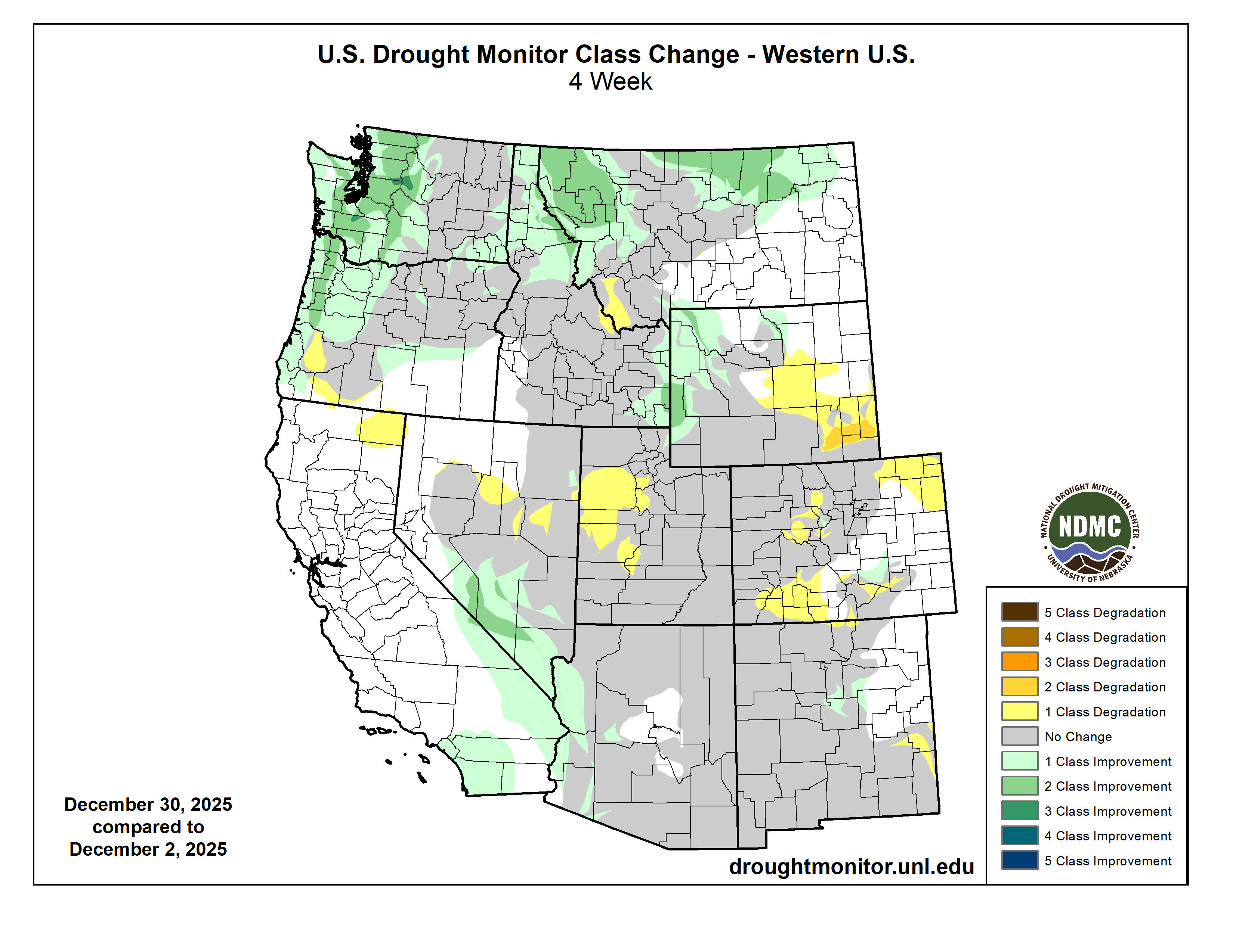
Regional drought coverage remained the same at 54% during December. Most of eastern Colorado and eastern Wyoming remain drought-free, but a pocket of exceptional (D4) drought developed in the northern mountains of Colorado in Eagle and Pitkin Counties. Coverage of severe (D2) drought decreased by 8% in Wyoming but increased in Utah by 13%. There were two pockets of 2 Class Improvement in drought in western Wyoming and a pocket of 2 Class Degradation in drought in southeastern Wyoming.
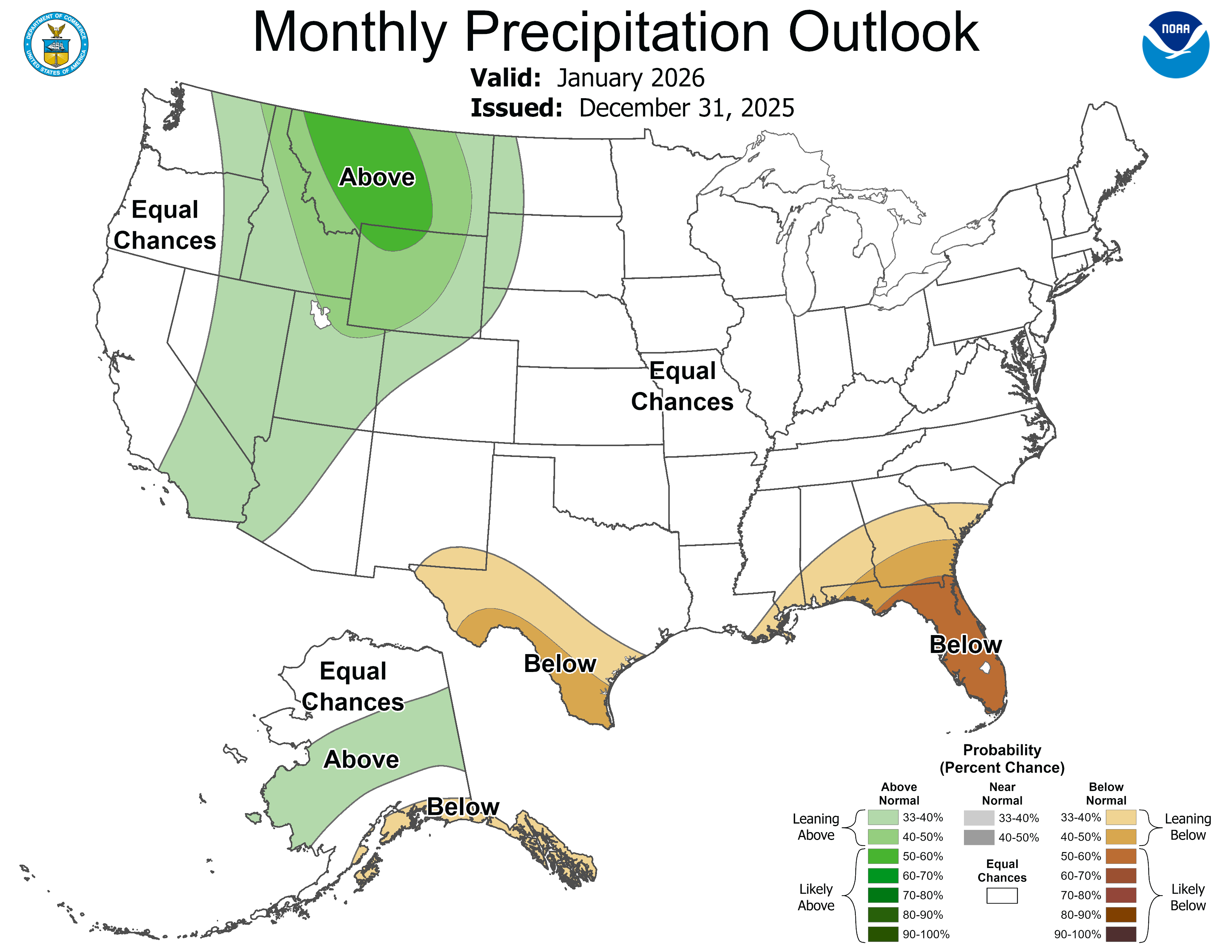
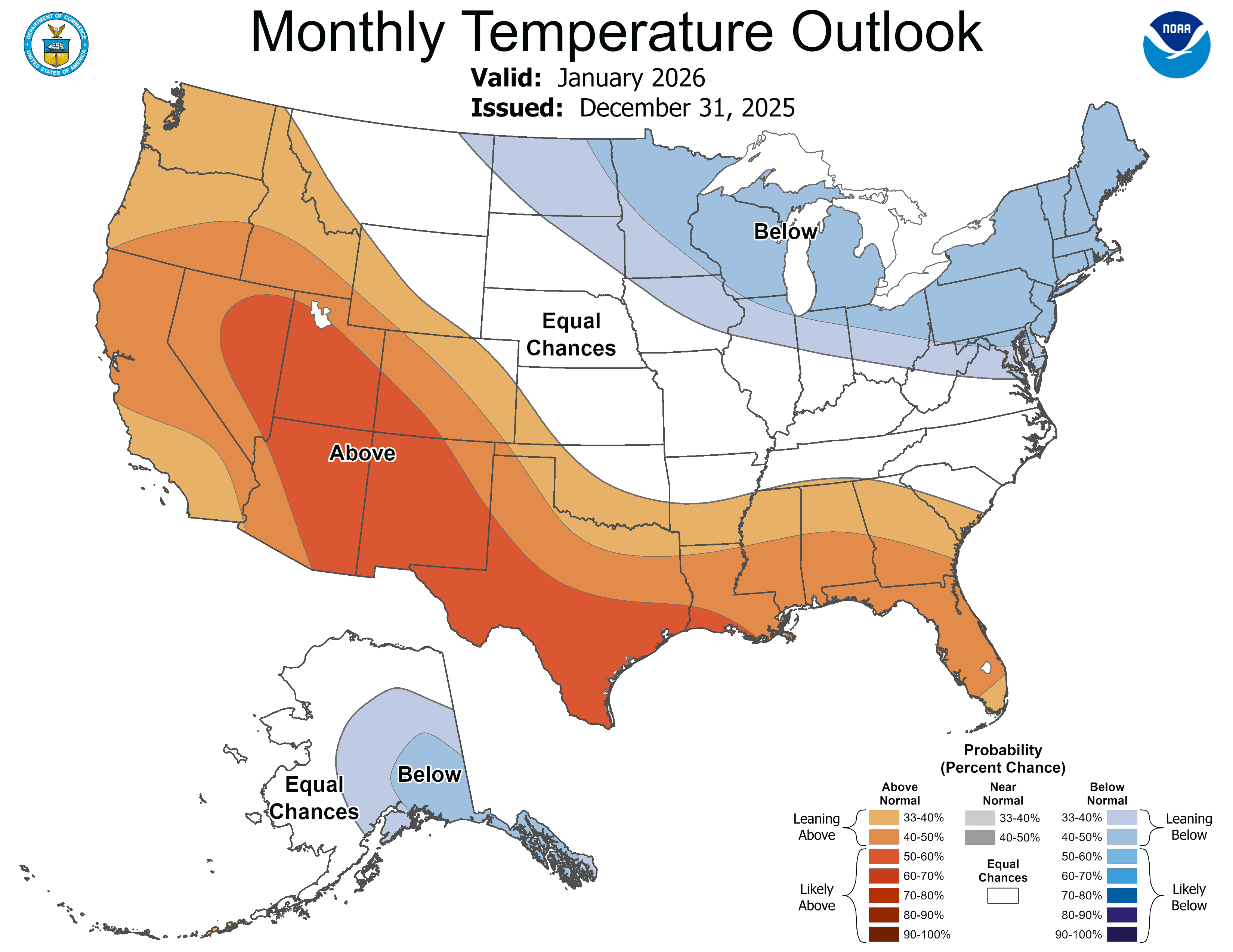
A La Niña Advisory is still in effect as eastern Pacific Ocean temperatures are below average. La Niña conditions are expected to transition (65% probability) to ENSO-neutral conditions during January-March. The NOAA January Precipitation Outlook suggests an increased probability of above average precipitation in Wyoming, Utah, and northwestern Colorado. The NOAA January Temperature Outlook suggests an increased probability of above average temperatures in Utah, Colorado, and southwestern Wyoming. The NOAA Seasonal Outlooks for January-March suggest an increased probability of above average precipitation in Wyoming and below average precipitation in southern Utah and southern Colorado, and above average temperatures throughout much of Colorado and Utah and below average temperatures in northeastern Wyoming.


Significant weather event: High wind events on the Front Range. On December 17 and 19, the Front Range of Colorado faced two severe windstorms that brought hurricane-force gusts, widespread damage and power outages, and significant wildfire danger. On December 17, the first of the two high wind events occurred, where the strongest peak gust in the Front Range reached 109 mph at the National Center for Atmospheric Research (NCAR) Mesa Lab in south Boulder, followed by peak gusts of 102 mph at Rocky Flats and 96 mph in Marshall, both south of Boulder. In the mountains, some ski resorts reported even stronger gusts, reaching 124 mph at Breckenridge’s Peak 6 and 124 mph at Winter Park’s Parsenn Bowl. Ahead of this wind event, Xcel Energy initiated a Public Safety Power Shutoff (PSPS) for nearly 50,000 residents in Boulder, Clear Creek, Jefferson, Larimer, and Weld Counties to prevent wildfire ignition from downed power lines. By sunset, more than 115,000 people were without power due to the windstorm. On December 18, the National Weather Service issued a Particularly Dangerous Situation for December 19 along the Front Range, the first time in Colorado history. On December 19, the second high wind event slammed the Front Range again, coupled with warmer winds and an even lower relative humidity under 10%. The strongest peak gust reached 113 mph at the NCAR Mesa Lab in Boulder, likely the strongest wind recorded at that location in over 10 years, and nearly as strong as the peak gust of 115 mph recorded near Highway 93 during the Marshall Fire in December 2021. Xcel Energy implemented another widespread power shutoff due to the extreme wildfire conditions, cutting power to 69,000 residents in the morning, with another 20,000 people already without power due to damage from the previous windstorm and power shutoff.
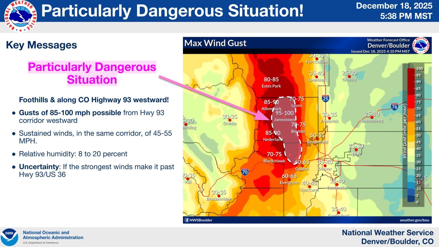
Image credit: NWS Boulder on December 18, 2025. "PARTICULARLY DANGEROUS SITUATION FRIDAY. We rarely issue these, but Friday will be a Particularly Dangerous Situation regarding potential for rapid wildfire spread in and immediately adjacent to the Boulder/Jefferson County foothills. Be ready to take swift action."
Sources:
https://www.cpr.org/2025/12/17/xcel-power-shutoff-high-winds-wednesday/
https://www.cpr.org/2025/12/19/nearly-90000-xcel-customers-without-power-friday-morning/
https://en.wikipedia.org/wiki/December_17%E2%80%9320,_2025_North_American_storm_complex
https://www.nytimes.com/2025/12/19/weather/denver-winds-fire-colorado.html