August 6, 2025 - CO, UT, WY
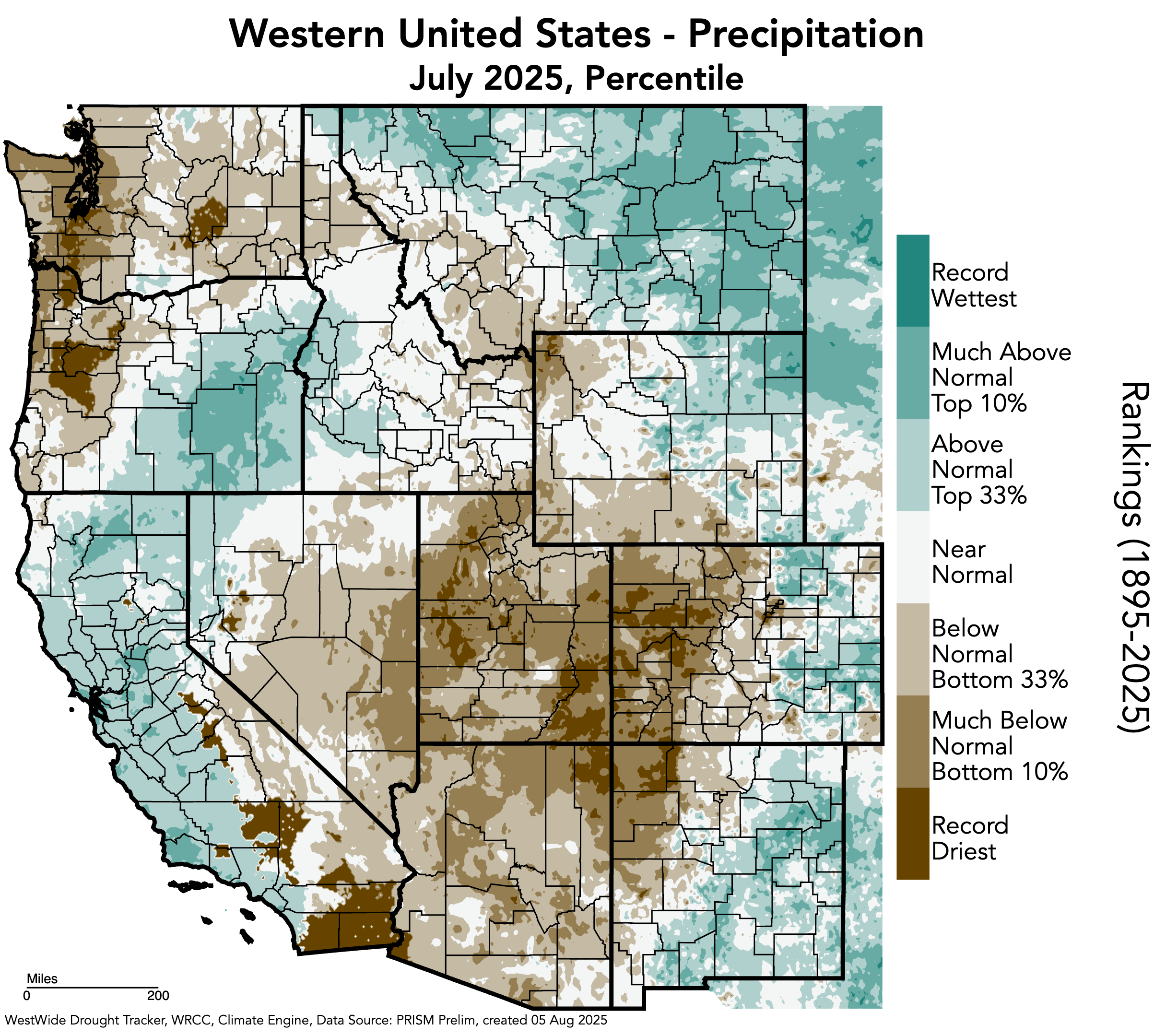
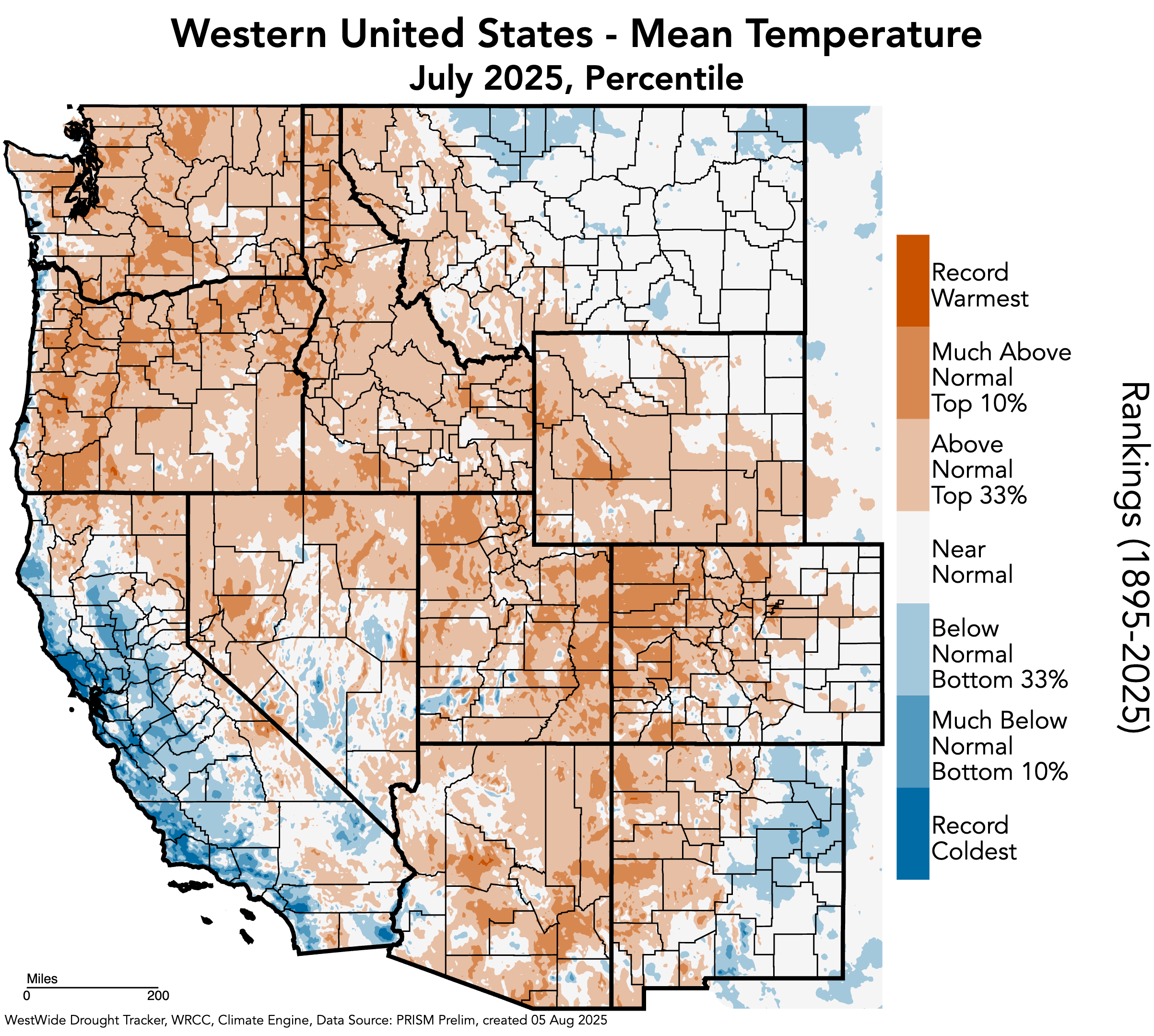
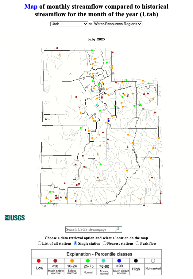
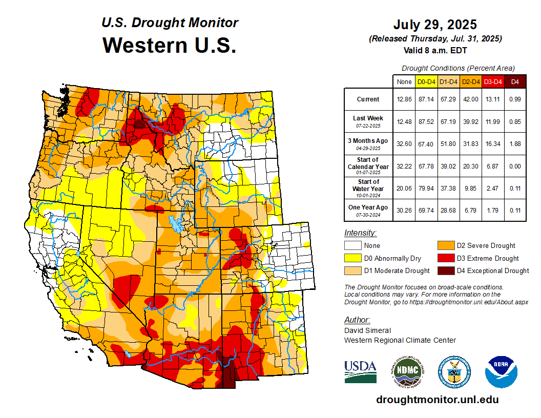
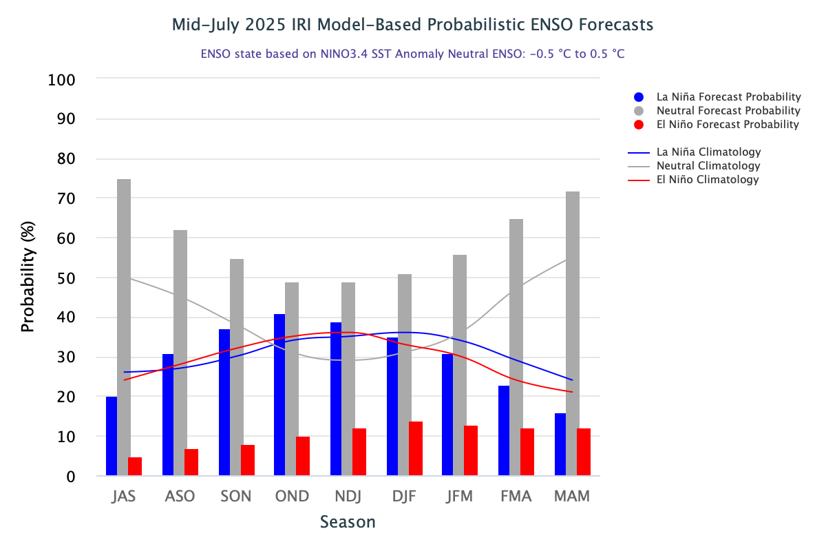
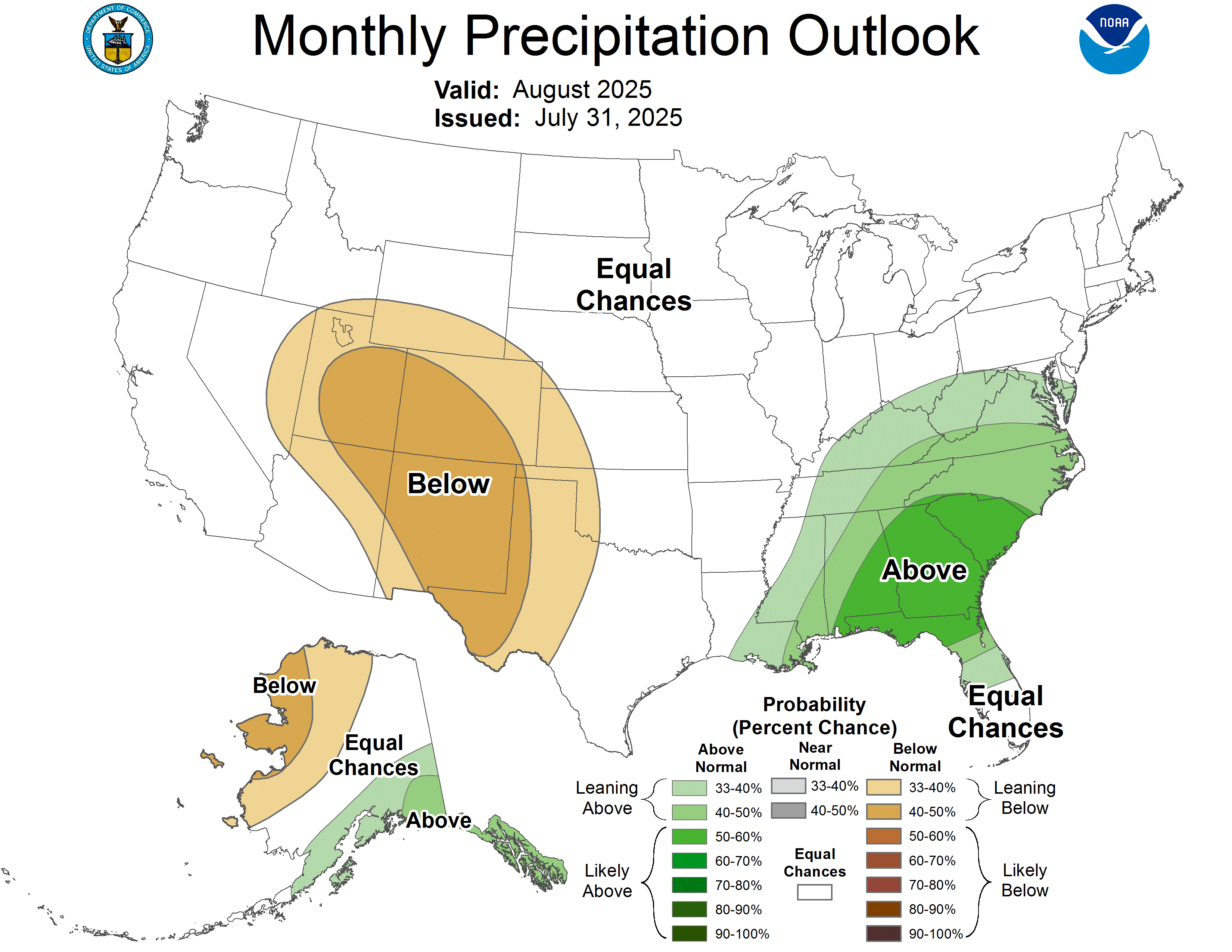
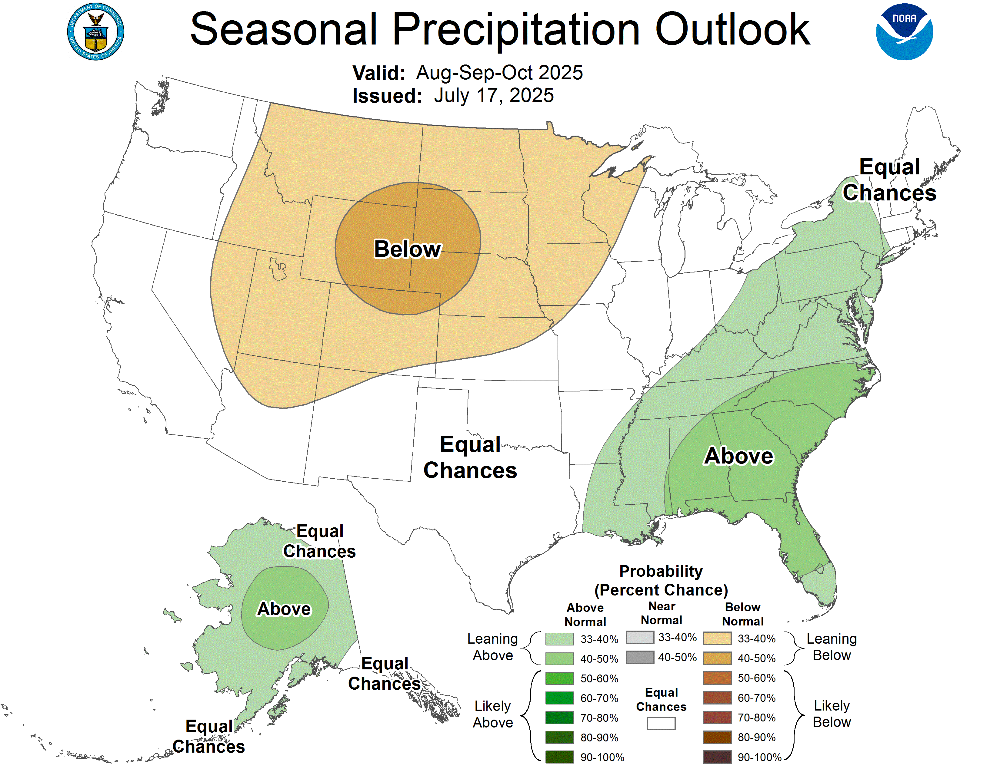
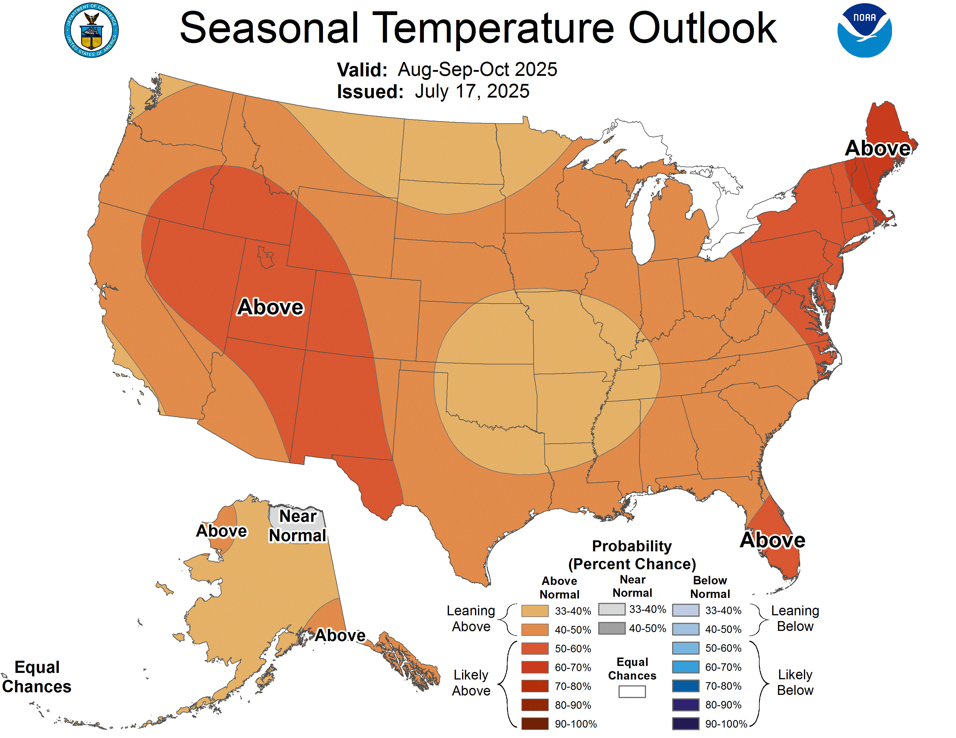
In July, regional precipitation was generally below normal, with record-dry conditions throughout much of the region, including western and southeastern Utah and the West Slope of Colorado. Regional temperatures were generally above normal, with much above normal temperatures throughout much of Utah and western Colorado. Regional streamflow was normal to much below normal, with much below normal conditions observed in many river basins throughout each state. As of August 1, Colorado reservoirs are 63% full, Utah reservoirs are 75% full, and Wyoming reservoirs are 72% full. Regional drought coverage in late July was 62%, with extreme drought expanding in western Colorado and developing in Utah. ENSO-neutral conditions are expected to continue through early fall. The NOAA seasonal outlook for August-October suggests an increased probability of below average precipitation and above average temperatures in the region.
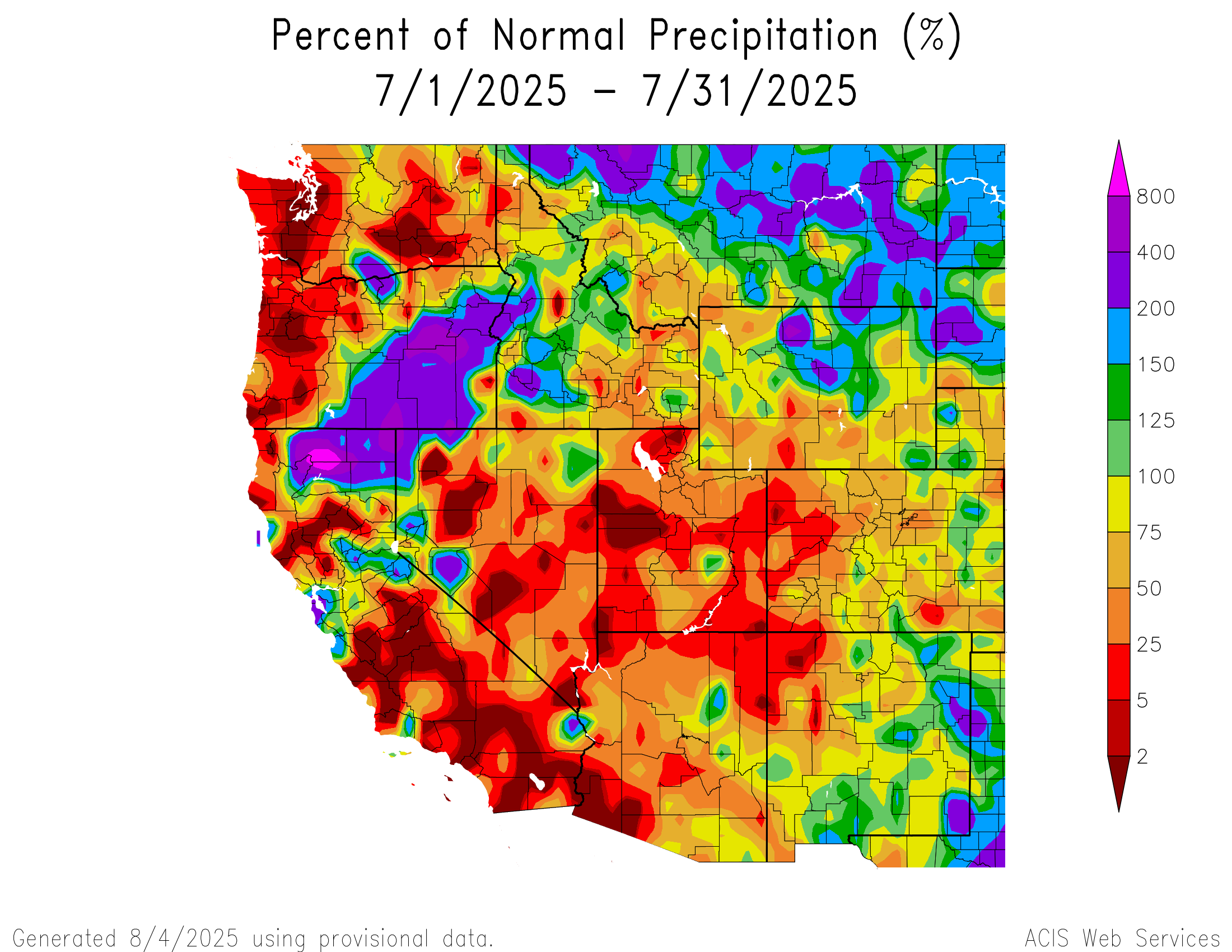
Regional July precipitation was below normal for the majority of Utah, western Colorado, and southern Wyoming. Large swaths of 5-25% of normal conditions occurred throughout Utah and western Colorado, and a large pocket of less than 2% of normal conditions occurred in Tooele, Juab, and Millard Counties in western Utah. Smaller pockets of less than 2% of normal precipitation occurred across Utah, including in Washington, Cache, San Juan, and Beaver Counties. Record-dry conditions occurred throughout much of western and southeastern Utah and the West Slope of Colorado, with small pockets scattered throughout Utah, Park and Teton Counties in Wyoming, Jefferson, Arapahoe, and Douglas Counties in the Denver metro, and more. Small pockets of above normal precipitation occurred in northern and southeastern Wyoming, eastern and southern Colorado, and Emery County in Utah. Pockets of 150-200% of normal conditions occurred in Washington County in Colorado and Laramie County in Wyoming, with large swaths across north-central and northeastern Wyoming. Large pockets of 200-400% of normal conditions occurred in several Wyoming counties, particularly in Sheridan, Big Horn, Washakie, and Natrona Counties. One pocket of 400-800% of normal precipitation occurred in Big Horn County in northern Wyoming.
Regional July temperatures were near to above average. In July, temperatures were two degrees above normal for much of the region, except for southern and eastern Colorado and southwestern Utah where temperartures were two degrees below average. In northern Colorado, northern Utah, and western Wyoming, July temperatures were two to four degrees above average. Pockets of four to six degrees above average temperatures were observed in Park County, Wyoming, and between Uintah and Carbon Counties in Utah. July temperatures were in the top 10% of historical observations throughout much of Utah and Colorado, particularly in northern and eastern Utah and western Colorado, the Front Range and the southwestern half of Wyoming.

July streamflow was below normal throughout the region except for eastern Colorado and eastern Wyoming where average July streamflow conditions were observed. Below to much below normal streamflow conditions were observed throughout the region, particularly in western Colorado, western Wyoming, and most of Utah. Several USGS stream gauges reported July streamflow conditions in the lowest 3% of all historical observations, including four in Colorado, two in Wyoming, and one in Utah.


As of August 1, Colorado reservoirs are 63% full and at 83% of median capacity, Utah reservoirs are 75% full and at 100% of median capacity, and Wyoming reservoirs are 72% full and at 87% of median capacity. There are many reservoirs with 80% or more of capacity, including Carter Lake, Horsetooth, Lake Granby, and Morrow Point in Colorado, East Canyon, Flaming Gorge, Jordanelle, Scofield, Strawberry, and Utah Lake in Utah, and Alcova, Belle Fourche, Buffalo Bill, Fontenelle, and Jackson Lake in Wyoming. Reservoirs with less than 60% capacity include McPhee, Navajo, and Pueblo in Colorado, Lake Powell and Willard Bay in Utah, and Angostura, Glendo, Keyhole, Pathfinder, and Seminoe in Wyoming.

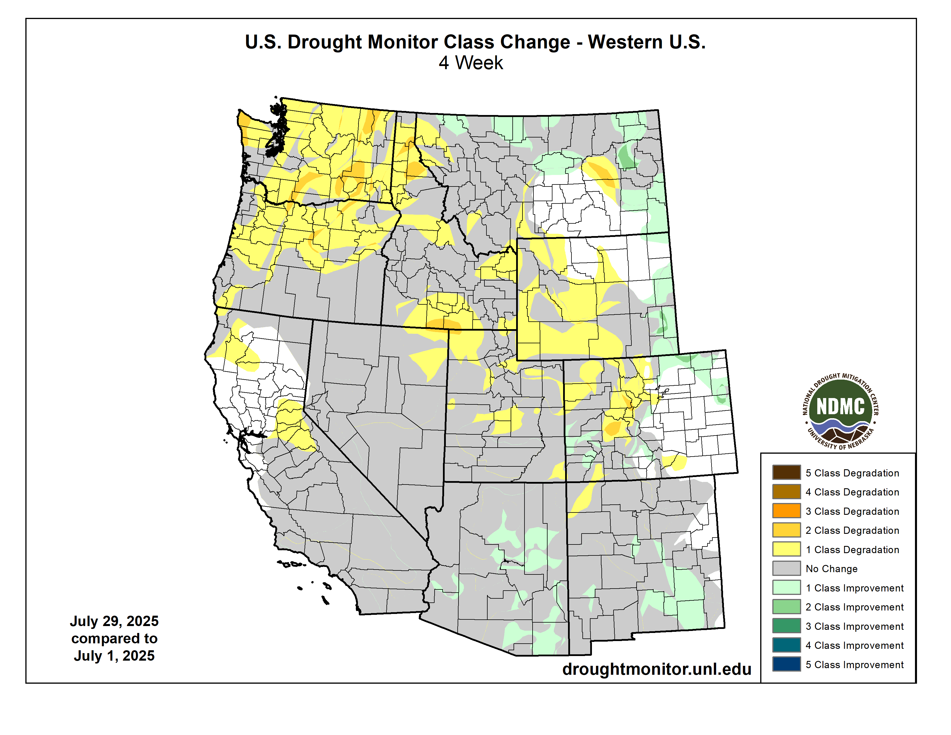
On July 29, moderate (D1) drought conditions covered 62% of the region, nearly unchanged since July 1. Severe (D2) drought expanded by 8% in Colorado, 16% in Utah, and 19% in Wyoming. Extreme (D3) drought expanded by 4% on the West Slope of Colorado, developed in Utah to 2% coverage, and remains at 0% in Wyoming.
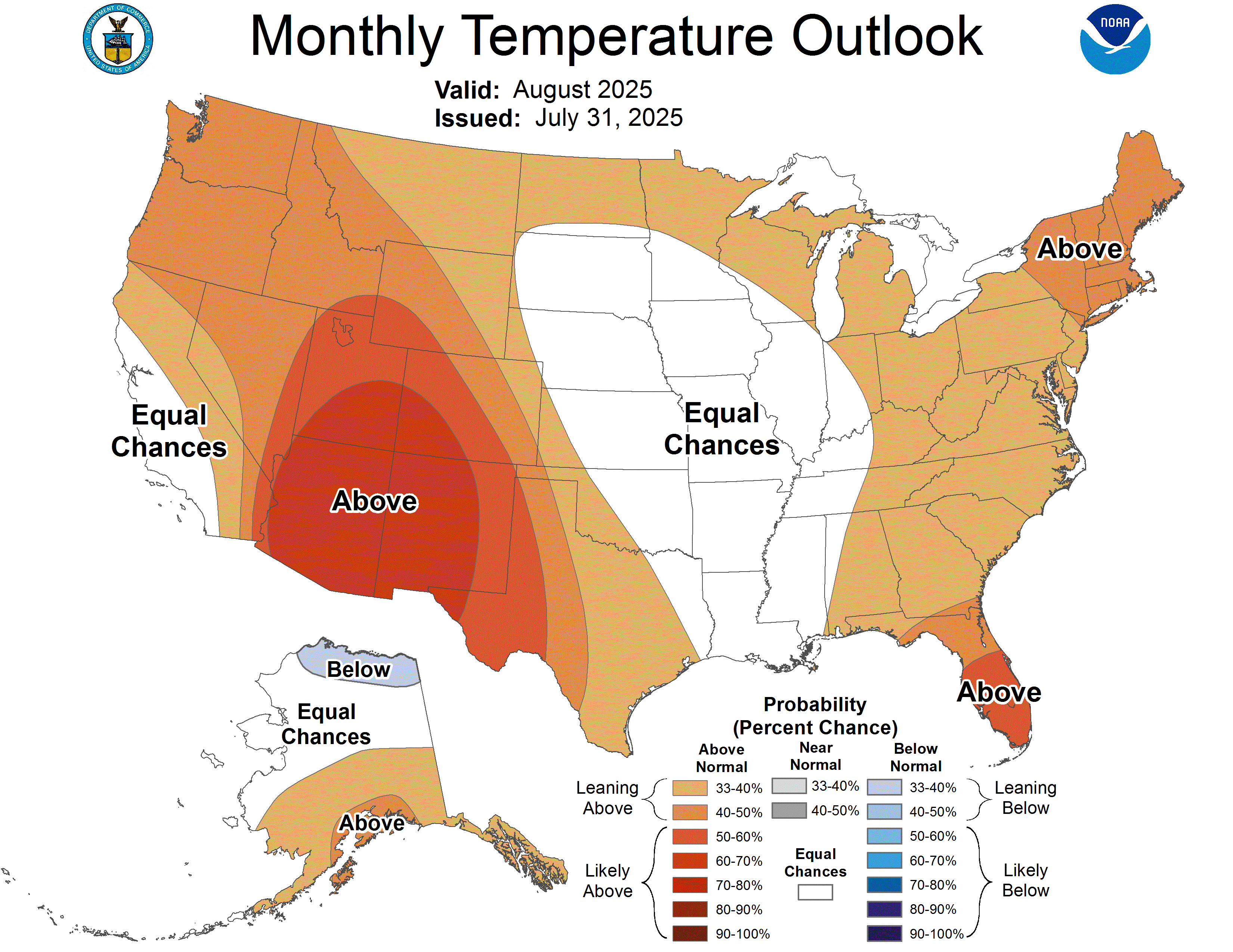
ENSO-neutral conditions continued in July, and ENSO-neutral conditions are favored through the rest of the summer with chances exceeding 50% through early fall. The NOAA monthly outlook for August suggests an increased probability of below average precipitation in Colorado, Utah, and southern Wyoming, and above average temperatures throughout the region, particularly in southern Utah and southwestern Colorado. The NOAA seasonal outlook for August-October suggests an increased probability of below average precipitation throughout the region, particularly in eastern Wyoming and northern Colorado, and above average temperatures throughout the region, particularly in Utah, western Colorado, and southwestern Wyoming.
Significant weather event: Large wildfire in Utah. The Monroe Canyon Fire began on July 13, 2025, near Richfield in Sevier County, Utah, and is currently the largest active wildfire in Utah. As of August 6, it has burned approximately 64,957 acres and is 15% contained. The cause remains undetermined. However, Utah Governor Spencer Cox said 72% of this year's Utah wildfires were human-caused. During a press briefing on August 1, Governor Cox said, “I haven’t begged in a long time. I’m begging people right now to please exercise extreme caution.” Governor Cox declared a 30-day state of emergency to mobilize resources and protect lives, property, livestock, drinking water supplies, and critical infrastructure. On August 3, fire crews were able to gain some control amid lower temperatures and milder winds and have since made progress in containment efforts along Highway 24 and in areas like Elk Country, Bagley Ranch, and Manning Meadows. Some evacuation orders have been lifted, but officials continue to urge caution due to the ongoing fire danger. The fire is under red flag conditions that are predicted to remain at least until the end of the week, with high temperatures, low humidity, strong winds, and critically dry fuels contributing to these conditions. These challenges follow record-low snowpack in the mountains near the fire. Additionally, several thunderstorms are expected to pass through the area later in the week, but unfortunately, they will not bring moisture with them.
Sources:
https://governor.utah.gov/press/gov-cox-declares-state-of-emergency-as-wildfires-intensify/
https://www.abc4.com/news/central-utah/containment-jumps-monroe-canyon-fire-red-flag/
https://www.foxweather.com/weather-news/utah-state-of-emergency-wildfires-monroe-canyon-august-2025