Compound Hazards and the Marshall Fire (January 13, 2022)
This briefing represents our state of knowledge as it exists January 13, 2022 and is provided as a service to place the disastrous fire into a weather and human context. We acknowledge that more information will come to light as research continues in the months and years on this event and so this should be seen as a ‘first look’ summary and is not intended to be a comprehensive or definitive report. The Western Water Assessment Team expresses our deepest condolences to the families who lost loved ones, pets and their homes in the fire.
During the late morning of December 30, 2021, the Marshall Fire ignited near the foothills of Boulder County, CO. The fire very quickly spread through dry grasslands and into suburban areas of Superior, then Louisville. The fire’s spread was fueled by a windstorm that produced wind gusts exceeding 100 miles per hour (mph), with sustained winds of over 45 mph for 8 hours. Extreme drought conditions and a very warm and dry August–December primed the area for wildfire. Most of the 1,084 structures (including 991 residential homes and 7 commercial properties) that burned in Superior and Louisville were consumed over a 6-hour period coinciding with the peak of the downslope windstorm. Two fatalities and an estimated $513 million in damages have been attributed to the Marshall Fire, making it the most destructive in Colorado history in terms of cost and structures lost.
Conditions leading to the Marshall Fire
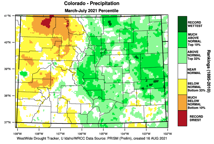
The story of the Marshall Fire began nearly a year before the fire burned. After below-average precipitation during winter, a very wet spring and early summer followed, bringing relief and optimism for reduced fire risk in Boulder County.1 The March through July period in 2021 was the 7th wettest on record in Boulder with 17.14” of precipitation.2 To put that number in perspective, Boulder received 80% of its annual rainfall in five months. The anomalously wet spring supported high growth of grasses in the prairie that covers much of the open space in Boulder County east of the foothills. Grass in Boulder County open space likely continued growing and remained green through July; the bountiful spring of grass growth would subsequently turn into the fuel that allowed the Marshall Fire to spread.
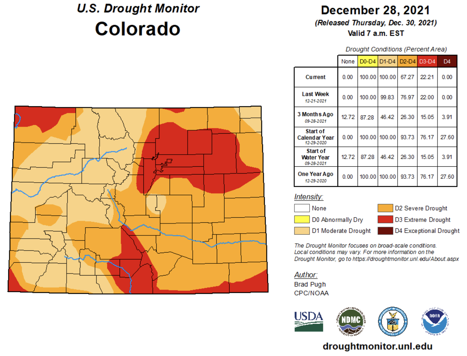
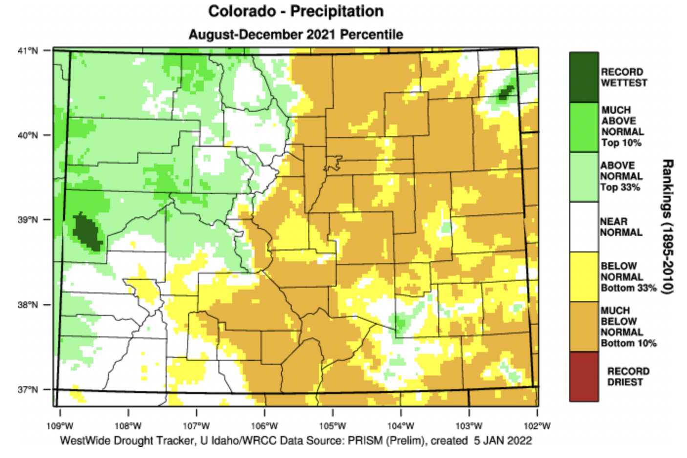
Boulder County began 2021 in severe (D2) drought, but by early June, drought conditions were completely gone from Colorado east of the Continental Divide. Abnormally dry conditions (D0) returned to Boulder County by late September. Drought conditions quickly worsened and by early November, parts of Boulder County including Superior and Louisville were experiencing extreme (D3) drought conditions.1 The rapid emergence and deterioration of drought conditions was caused by low precipitation and extremely warm August–December temperatures. August–December 2021 was the second driest (1.86”) on record in Boulder since 1893.2 August–December was also extremely warm; it ranked as the 7th hottest August–December period and the 3rd hottest November–December period on record in Boulder since 1893.2
Another factor necessary for the Marshall Fire to spread from grasslands to structures was a lack of snow. Snow drought also played a significant role in creating conditions suitable for extreme fire behavior. Denver received its latest first snowfall ever in 2021 when it snowed 0.3” on December 10th, breaking the previous record by three weeks. In Boulder, only 1.7” of snow was observed from September 1st to December 30th, 2021, the lowest snowfall total on record for those months (Table 1). December 2021 received the 12th lowest snowfall since 1893.5

On December 30th, Boulder and the surrounding communities were entirely snow-free. Since 1893, there was at least a trace amount of snow on the ground in Boulder on December 30th in 47% of years and at least 1” of snow on the ground in 27% of years.5 If there had been snow cover, even under extreme drought conditions, the fire would likely not have spread across the grasslands east of Superior and Louisville. Even in years when snow cover was absent, wind drifts from previous snowfalls that form in the rolling hills between the foothills and suburban areas could have potentially limited or slowed the spread of the fire. Snow drought, not just drought conditions, was a primary factor in creating the conditions that allowed the Marshall Fire to occur.
Extreme winds on the Front Range
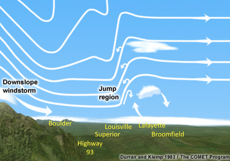
High winds are relatively commonplace in Boulder and along the Front Range due to geography (the Rocky Mountains) and the prevailing westerly flow of storms. The most extreme wind events in Boulder occur as downslope windstorms from the west. These downslope windstorms occur most commonly during winter when a high-pressure weather system sits to the west of the Continental Divide and low pressure is located immediately east of the foothills. As the air mass moves from high to low pressure, westerly winds accelerate as they move down the eastern slope of the mountains and can further accelerate as winds are channeled into canyons with an east-west orientation. During a downslope wind event, wind gusts can exceed 100 mph and last from hours to a day. High winds from downslope windstorms do not typically extend very far into the plains. Since 1970, wind speeds have exceeded 70 mph on an average of 4.8 days per year in the Boulder area; with over 50% of high wind days occurring in December and January.6

The size, speed and magnitude of destruction caused by the Marshall Fire was driven by a downslope windstorm that began on the morning of December 30th. Westerly winds were highest from the base of the foothills eastward to Superior and Louisville. Further east in Lafayette and Broomfield, wind speeds rapidly diminished and switched directions to blow from the east.7 This phenomenon is called an atmospheric mountain wave, where winds accelerate down the slope of mountains, extend only a short distance downwind from the mountains, then subside further downwind and blow in the opposite direction, much like the backward flowing current behind a rock in a swift river. Wind gusts peaked between 68–108 mph at weather stations near the fire in Boulder County, with the highest wind speeds closer to the foothills. The windstorm’s peak wind gust of 115 mph was observed south of the Marshall Fire in Arvada, CO.7
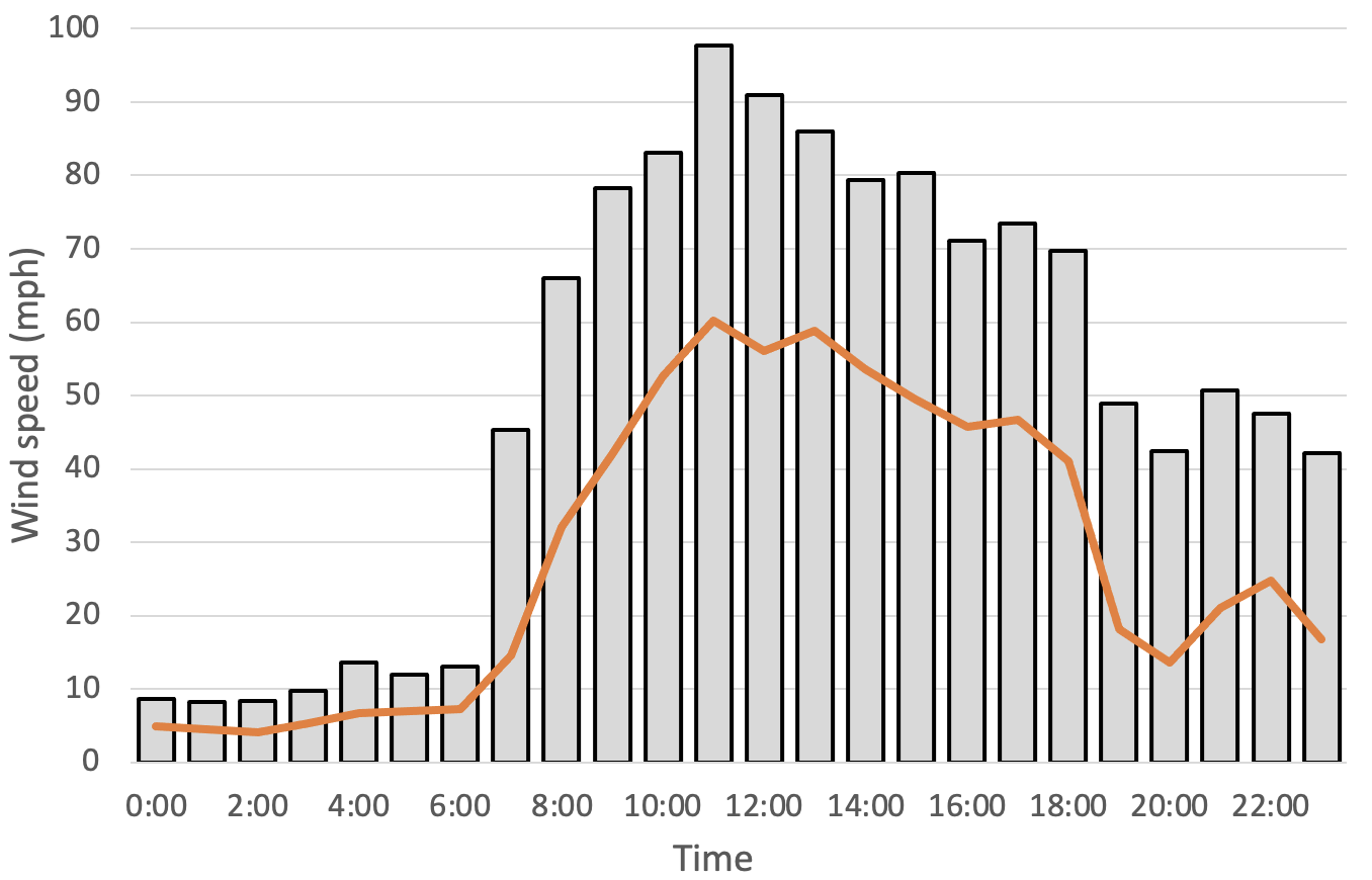
Westerly winds intensified in Boulder at 7:30 am and reached peak intensity with a gust of 98 mph at 11:55 am. Five wind gusts exceeding 90 mph and 43 wind gusts exceeding 80 mph were recorded at the NREL Flatirons campus a few miles northwest of the fire ignition area. Sustained winds of more than 45 mph were observed for 8 hours, from 9:00 am to 5:00 pm.6 The fire was presumed to have started near the intersection of Marshall and Eldorado Roads south of Boulder at about 11:30 am, which coincided with the peak intensity of the windstorm. According to a summary by the NWS Denver/Boulder Weather Forecast Office, the area of peak wind intensity shifted eastward over Superior and Louisville between 12:00 and 2:00 pm as the fire moved from grasslands into suburban areas.7
Compound Natural and Human Hazards
The Marshall Fire was human-caused, but a series of concurrent and compounding natural and human hazards created the conditions for the fire to scorch 6,200 acres of grassland and suburban landscapes. It is extremely unlikely that a wet spring, drought, snow drought, high temperatures or the downslope windstorm alone could have created the conditions necessary for the Marshall Fire’s ultimate extent and devastation. All five of these natural hazards were required to occur in the sequence they did to create the extreme fire conditions present on December 30th. If any one of these hazards were less severe or happened in a different order, the fire would not likely have spread so quickly and widely. Humans also played a critical role in creating conditions for the disaster. The manner in which communities developed the built environment in Boulder County, the way the land is managed, and how humans relate to hazards were all involved in the outcome.
The Wildland Urban Interface (WUI) is the geographic space where natural ecosystems border the built environment. The WUI is a critical zone in the context of wildfires and how fires interact with human development. Wildfire risk in communities adjacent to or within the WUI is typically highest with forested ecosystems. Communities located within or adjacent to forests in arid regions of the West are typically very aware of the risk wildfires pose and significant efforts are made to make homes and businesses resilient to fire. Adaptation strategies like creating fire-defensible spaces around properties are employed. Residents may be prepared for rapid evacuation, especially during fire season, and know evacuation routes. The Marshall Fire started and burned miles away from the lodgepole pine forests of the foothills. It spread as a grassland wildfire, but ended as an urban and suburban conflagration. Many residents, hazard professionals, and scientists alike did not think a fire could burn so far into suburban areas, especially in December. The Marshall Fire was the second most destructive fire to occur in the United States during December. It should expand the notion of both timing and location of fire risk on the Front Range of Colorado and in similar communities across the West.
A human component important to the Marshall Fire originates from the gap between perception of wildfire risk compared to the actual wildfire risk. The seasonal timing and location of the fire were outside of historical norms and many people did not understand the actual wildfire risk, in part, because of rapidly driving changes in wildfire timing and behavior. In Colorado, fire season was typically considered to span June–September. However, that traditional timing of fire season applies to Colorado forests where cooler temperatures, wetter conditions, and snow greatly reduce fire risk. In Boulder County, December was warm, dry and snow-free. Warmer and drier conditions will likely further expand the length of the fire season, into both the spring and fall. It is possible that fire season may shift so much in some years that fire danger can be high at any time of the year. Additionally, Superior and Louisville are in a WUI dominated by prairie, not forest. Grassland wildfires can have different seasonal timing and characteristics. Grassland fires are unusual in Colorado winter, but not absent from our history. On January 15th, 1950 high winds sparked a fire from smoldering vegetation that burned 32,000 acres of grassland at Fort Carson near Colorado Springs. Nine soldier and volunteer firefighters were killed battling the blaze and 92 buildings on Fort Carson were destroyed.8 More recently, high wind events contributed to grassland fires in Boulder County during the winter in 2006, 2009, 2017, and earlier in December 2021.9 None of these more recent fires grew to large sizes or burned structures, but provide evidence that wildfire risk, even in the dead of winter, remains a concern.
There was no red flag warning issued for heightened fire danger on the morning of December 30th10 and, for a variety of reasons, many residents did not receive emergency alerts to evacuate, prompting emergency managers in the state to review these alert systems.11,12 Additionally, the severity of the fire itself created challenges to both evacuation and fighting the blaze. Extreme wind speeds and smoke prevented aircraft from surveying the geographic area of the fire which severely limited the information available to both first responders and evacuees.
Management of natural landscapes in the Wildland Urban Interface and changes to those management practices are also important human factors related to fire risk. Much of the development in Superior and Louisville near current open space grasslands has occurred in the last 30 years, reflecting a significant change in land use and management. Future management of grasslands in the WUI of Boulder County should consider these factors in an effort to mitigate fire risk to adjacent communities.
Literature cited
1. U.S. Drought Monitor. Historical Data and Conditions. (2022).
2. NOAA. NOAA RCC xmACIS2. http://scacis.rcc-acis.org (2022).
3. National Drought Mitigation Center. US Drought Monitor Map Archive. (2021).
4. University of Idaho, WRCC & Desert Research Institute. WestWide DroughtTracker. https://wrcc.dri.edu/wwdt/ (2022).
5. NOAA National Weather Service - Boulder WFO. NowData - NOAA Online Weather Data for Boulder, CO. https://www.weather.gov/wrh/Climate?wfo=bou (2022).
6. D. Jager, A. A. NREL Report No. DA-5500-56489. https://midcdmz.nrel.gov/apps/sitehome.pl?site=NWTC (1996).
7. NWS Denver/Boulder Weather Forecast Office. High Winds and the Marshall Fire on December 30th, 2021. https://www.weather.gov/bou/HighWinds12_30_2021 (2022).
8. Shinn, M. Colorado Springs at 150 years: City’s deadliest wildfire killed 9, charred 150 square miles. The Gazette (2021).
9. NOAA Physical Science Laboratory. Boulder wind info. (2021).
10. Lebel, J. No red flag warning issued during Marshall Fire: Do criteria need to change? (2022).
11. Cobb, E. In wake of Marshall Fire, Louisville residents raise concerns over lack of emergency warnings. Daily Camera (2022).
12. Wang, B. Officials analyze Marshall Fire emergency response and concerns regarding evacuationn notices. TheDevnverChannel.com https://www.thedenverchannel.com/news/marshall-fire/officials-analyze-marshall-fire-emergency-response-and-concerns-regarding-evacuation-notices (2022).