February 11, 2015
Highlights
- January was overall very dry for the region, with nearly all mountain areas receiving below-average precipitation.
- The region's snowpack has suffered since January 1 due to the dry and warm conditions, with most basins now reporting below-median SWE. Basins in southwestern Colorado and southwestern Utah remain the driest in the region, with less than 65% of median SWE.
- The February 1 spring-summer runoff forecasts show widespread reductions compared to the January 1 forecasts. Most forecast points are now in the below-average and much-below-average categories, with near-average runoff expected in central Colorado and northern and western Wyoming.
- "El Limbo" continues in the tropical Pacific; by some measures weak El Niño conditions are occurring, but the likelihood of an official El Niño event has dropped slightly compared to one month ago.
Click on the thumbnail images in the text below to bring up the full-sized graphic
January Precipitation and Temperatures, and Current Drought
In January, most of the region experienced drier-than-average conditions, including nearly all mountain areas . The driest areas were in western and southern Wyoming, and northwestern and north-central Colorado. Eastern Utah had the only large area with a wet anomaly for January. For the month, Wyoming ended up very dry overall, in the 8th percentile for statewide precipitation, Colorado in the 15th percentile, and Utah closest to normal, in the 33rd percentile.
As in December, January was warmer than average across nearly the entire region . Once again, the warmest areas were in northern Utah, northwestern Colorado, and southwestern Wyoming, with temperatures 6–10°F warmer than the monthly normal. All three states were in or near the top decile for monthly statewide average temperature: Utah, 95th percentile; Wyoming, 93rd percentile; and Colorado, 88th percentile.
The latest US Drought Monitor , based on conditions as of February 3, shows that since early January, a large area of western Colorado and adjacent far eastern Utah has degraded from drought-free to abnormally dry (D0). But the proportion of the region in D2 or worse drought remains the same: Utah at 13%; Colorado at 12%, and Wyoming at zero.
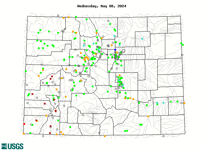
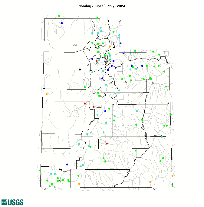
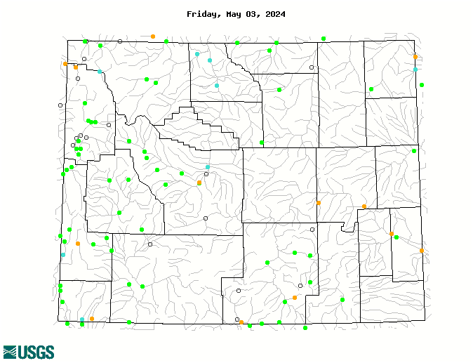
Current Streamflows
As of February 10, the maps of current streamflows for Colorado , Utah , and Wyoming show that for the relatively few gages unaffected by winter icing, flows are normal to above normal in Colorado and Wyoming, and mainly normal or below normal in Utah. Given the warm weather of the last month, the prevalence of normal and above-normal flows may in part be due to premature melt of lower-elevation snowpacks. On February 10, the Colorado River below Glenwood Springs, CO was in the 83rd percentile, 124% of median flow; the Green River near Greendale, UT was in the 57th percentile, 132% of median flow; and the San Juan River near Bluff, UT, was in the 49th percentile, 100% of median flow.
Current Snowpack
With the generally warm and dry weather since January 1, the snowpack has fallen behind normal accumulation across most of the region. The Current Basin Snowpack map from NRCS as of February 11 shows that majority of the region’s basins are now below 90% of median SWE, with southwestern Colorado and southwestern Utah stuck below 65% of median SWE. Above-median SWE is seen in several basins in northern and western Wyoming, one basin in south-central Utah, and the South Platte Basin in northeastern Colorado.
Spring-Summer Streamflow Forecasts
The February 1 spring-summer streamflow forecasts, released by NOAA CBRFC and the NRCS in early February, show widespread reductions in the expected runoff compared to the January 1 forecasts. The NRCS Westwide Streamflow Forecast Map shows that most forecast points in northern and central Colorado, and northern and western Wyoming are expected to have near-average (90–109%) spring and summer runoff. Most forecast points in central and southern Wyoming, northwestern and southern Colorado, and throughout Utah are expected to have below-average (70–89%) to much-below-average (50–69%) spring and summer runoff. The Lake Powell inflow forecast has fallen by about 20 percentage points since January 1; see Note below.
IMPORTANT NOTE: While NRCS and NOAA continue to collaborate on streamflow forecasts, the forecast values are no longer being strictly coordinated between NRCS and some of the RFCs, including the CBRFC. For example, the NRCS February 1 forecast for Lake Powell April–July inflows is 5000 KAF, 70% of average. The NOAA CBRFC February 1 forecast for the same point is 5200 KAF, 73% of average.
Seasonal Climate and Drought Forecasts, including ENSO
The monthly Climate Outlook for February released on January 31 by NOAA CPC shows no tilt for precipitation across the region. The seasonal outlooks released January 15 show a wet tilt in both the February–April and March–May periods for all of Colorado and most of Utah.
Given this wet tilt, the latest CPC Seasonal Drought Outlook released January 15 projects that most areas of drought conditions (D1 or worse) in southern Colorado and in southern Utah will improve or be removed by the end of April. Drought areas in far southeastern Colorado and in northwestern Utah are expected to persist or intensify. No additional areas of drought development in the region are expected.
The updated Experimental PSD Seasonal Precipitation Forecast Guidance ('SWcast') for the January–March period issued on January 15 continues to show a tilt towards above-average precipitation over most of Colorado and southern Utah. There is again a slight dry tilt forecasted for northern Utah. (Note: "Skill-masked" means that the forecast only shows the tilts for those areas where there has been demonstrated forecast skill for this season in the past.)
The median forecast of the Experimental PSD April 1 SWE Guidance issued on January 15 suggests that the Colorado River Headwaters will end up with above-normal SWE by April 1, with 103% of median, while the Gunnison and Rio Grande will be well below median, with 84%, with the other five basins falling in between with 90% to 96% of median.
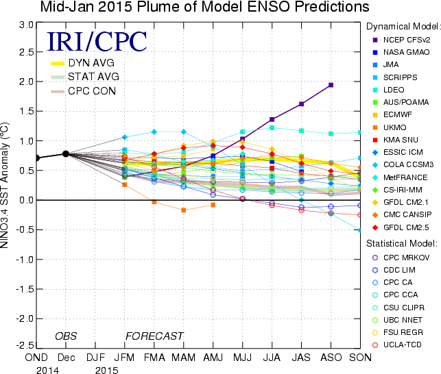
In the tropical Pacific region, the awkward movement towards full-blown El Niño conditions has slowed again. The Multivariate ENSO Index (MEI) remained in weak El Niño territory for the December–January period. The weekly benchmark Niño 3.4 sea-surface temperature (SST) index as of early February is still near the threshold for El Niño conditions, but has declined since December.
A slight majority (50-60%) of the individual ENSO model forecasts compiled by IRI in mid-January still favor El Niño conditions to emerge in spring 2015; this is about double the climatological odds of El Niño onset for this time of year. If an official El Niño does develop, is likely to be a weak event. The forecasts indicate very little chance of a La Niña event developing before summer 2015.