August 4, 2021 (UT, WY, CO)
-
Heavy monsoonal rains in Utah and Colorado during July led to above average precipitation, slight improvements to drought conditions and flooding. Most of the region experienced above average temperatures in July. Drought conditions improved slightly in Utah, but significantly worsened in parts of Wyoming. Despite above average July precipitation in much of the region, July streamflow in northern Utah rivers was at a record low and seasonal streamflow volume for many regional rivers was just above record low amounts.
-
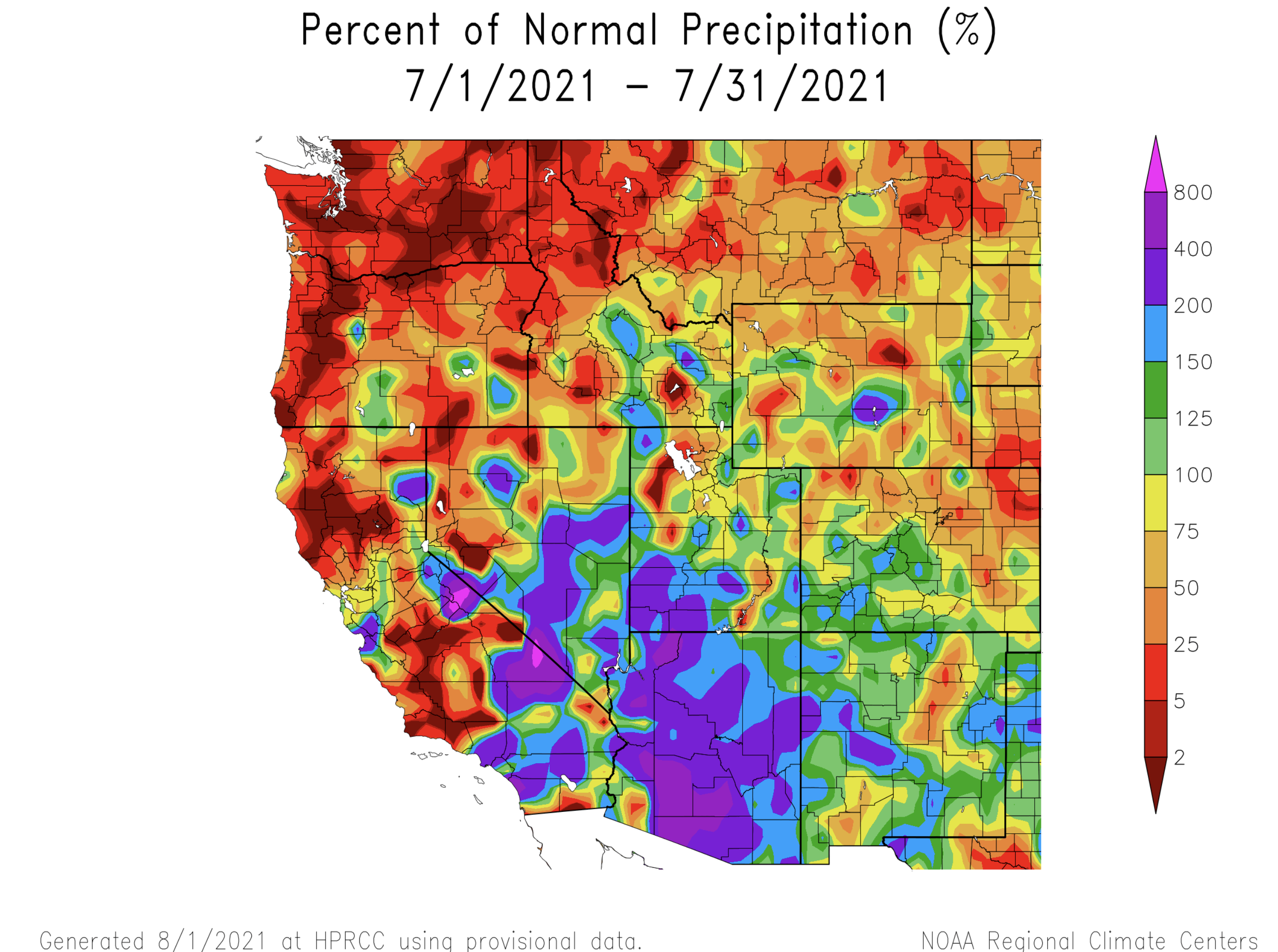
During July, monsoonal precipitation pushed northward into much of Utah and southern Colorado. Large areas of southwestern Utah received 150 – 400% of average July precipitation. Areas of southwestern and central Colorado received 125 – 200% of normal July precipitation. Isolated areas of northern Utah and Wyoming received average to slightly above average precipitation in July. Most rain during July fell as heavy downpours from monsoonal thunderstorms and led to flash flooding in Utah and Colorado and caused debris flows on several recent wildfire burn scars in Colorado, most notablly the Cameron Peak Fire scar (northern Colorado), the Grizzly Gulch Fire scar (Glenwood Canyon) and the Pine Gulch Fire scar (Grand Junction).
Image
-
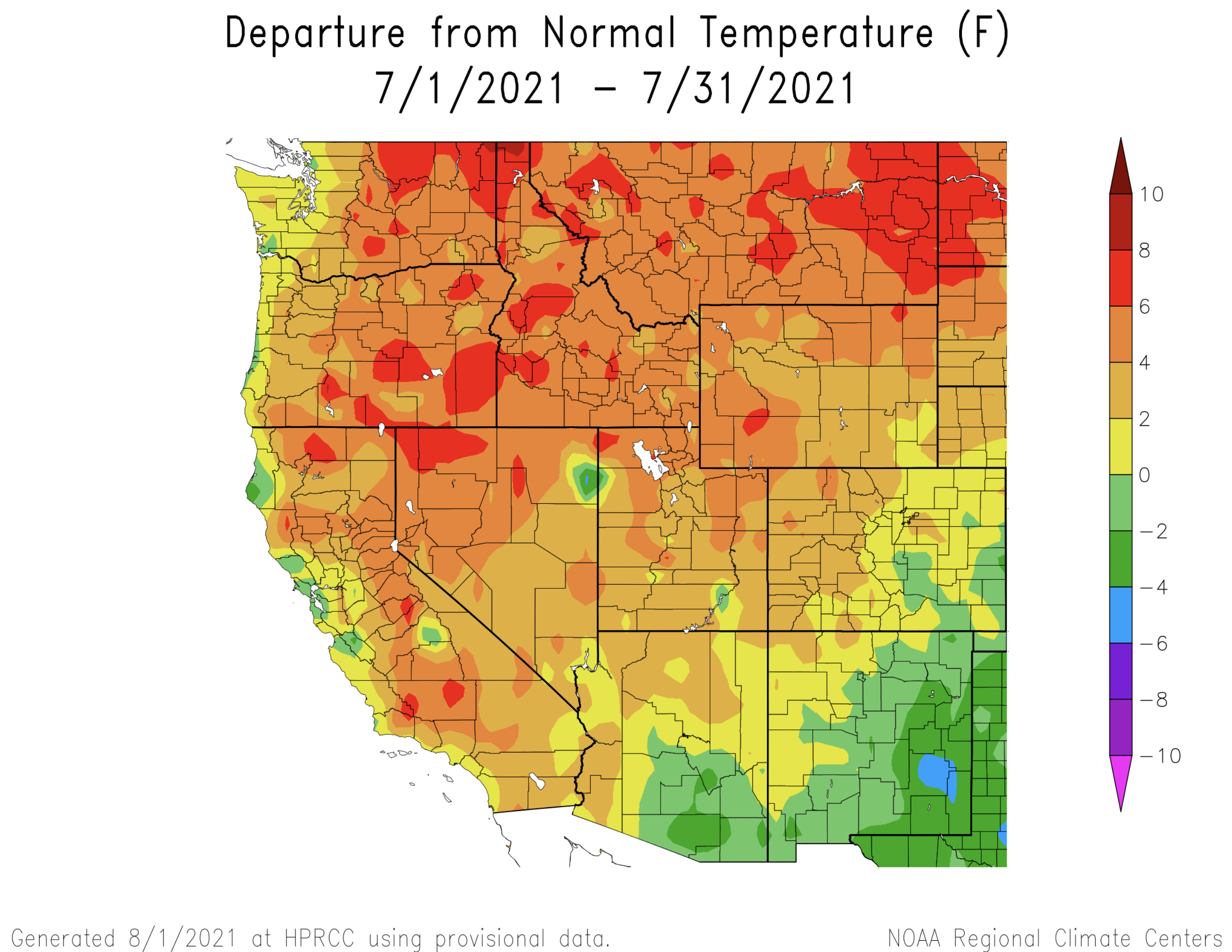
During July, temperatures were above average in Utah, Wyoming and northwestern Colorado. In most of Utah, July temperatures were 2 to 4°F above average and 4 to 6°F above average in northern Utah. In nearly all of Wyoming, July temperatures were at least 2°F above average and temperatures in northern and western Wyoming were 4 to 6°F above average. In eastern Colorado, July temperatures were near average and slightly above average in western Colorado.
Image
-
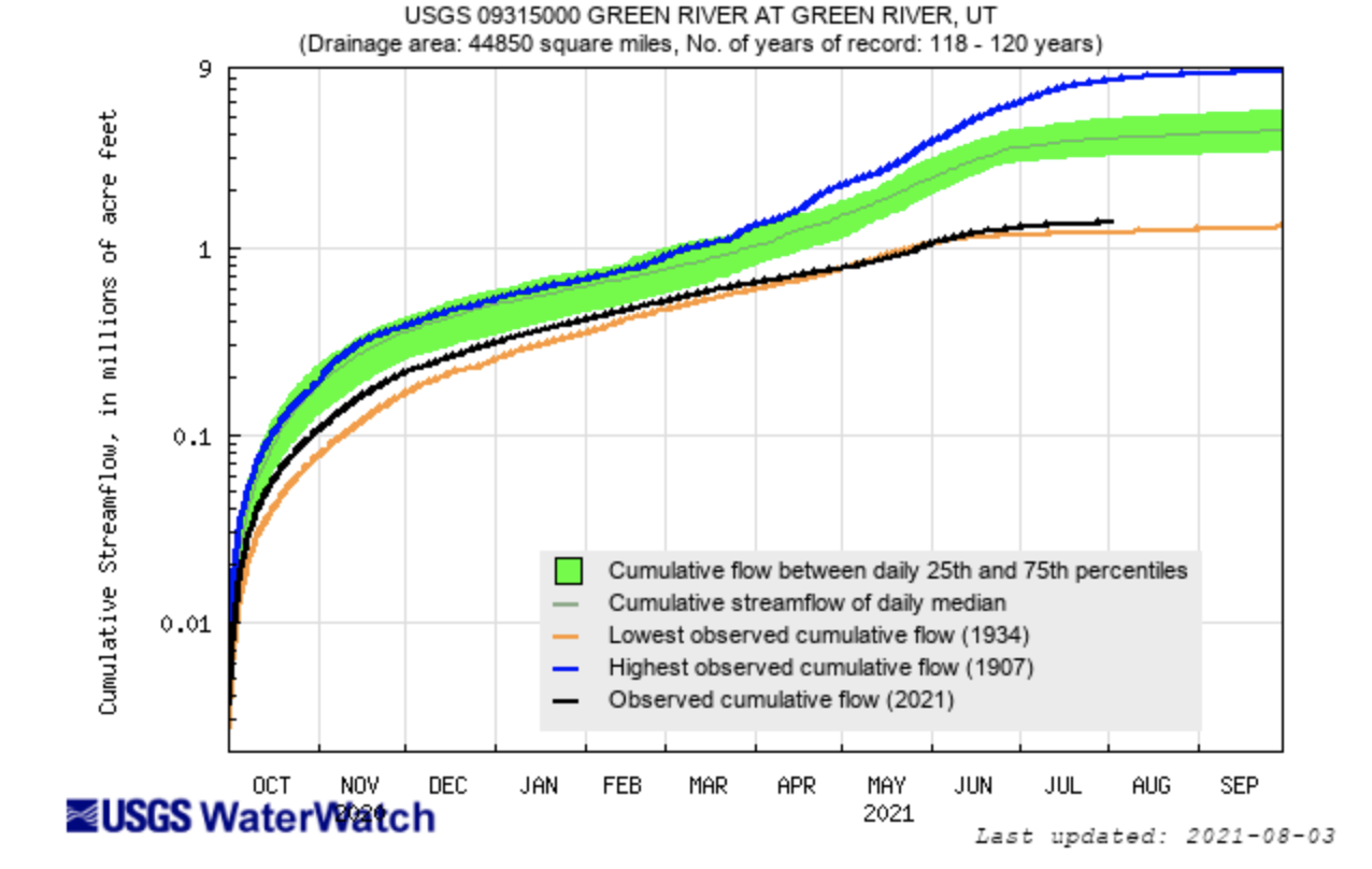
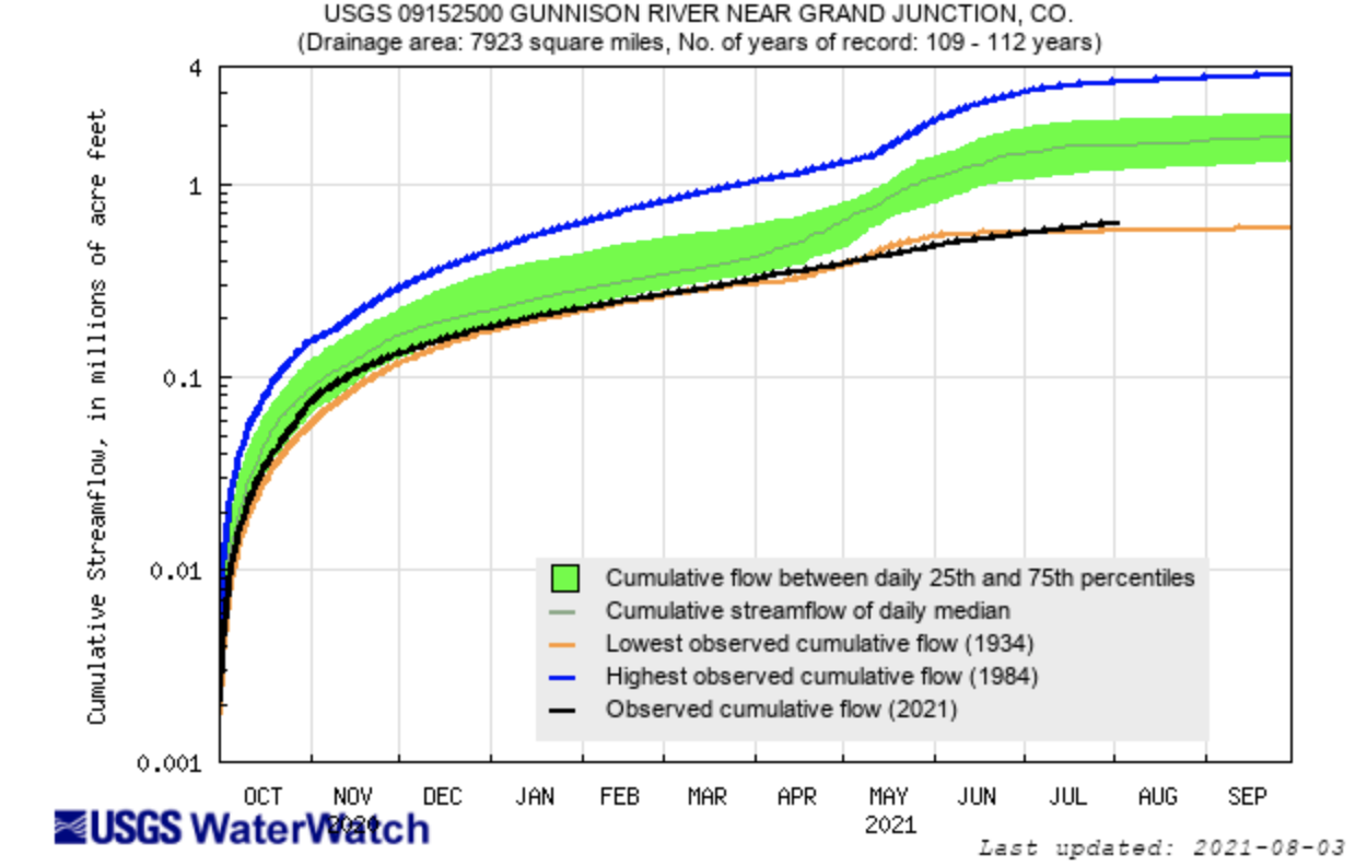
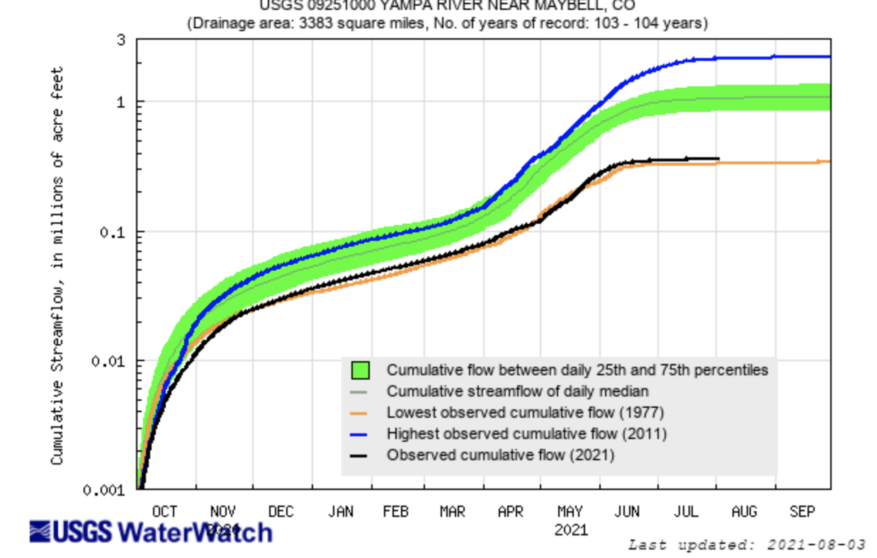
Monsoonal rainfall elevated streamflow to average levels in southern Utah, and southern and eastern Colorado. However, in northern Utah, monthly streamflow reached record-low levels on the Duchesne, Lake Fork, Logan, Provo and Weber Rivers and in Wyoming, record low July streamflow was observed on the Snake River above Jackson Lake and on the Little Snake River in southern Wyoming. Overall, the 2021 water year produced extremely low cumulative streamflow volumes on rivers west of the Continental Divide. As of August 3rd, annual streamflow volumes were at record low levels on the Weber River and very near record low levels on the Colorado (Cisco, UT), Green (Green River, UT), Gunnison (Grand Junction, CO), San Juan (Bluff, UT) and Yampa (Maybell, CO) Rivers.
Image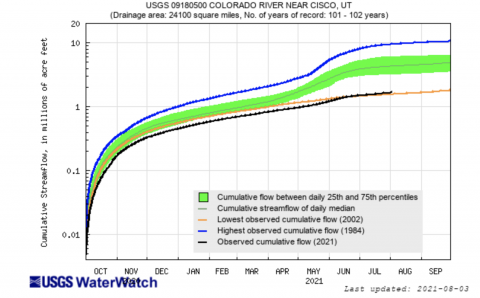 Image
Image Image
Image Image
Image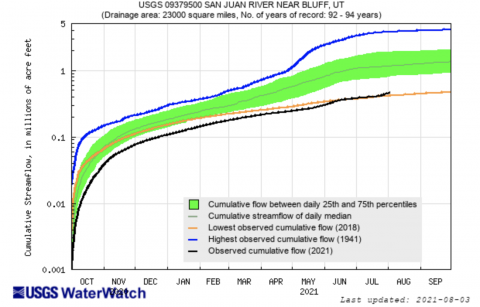 Image
Image
-
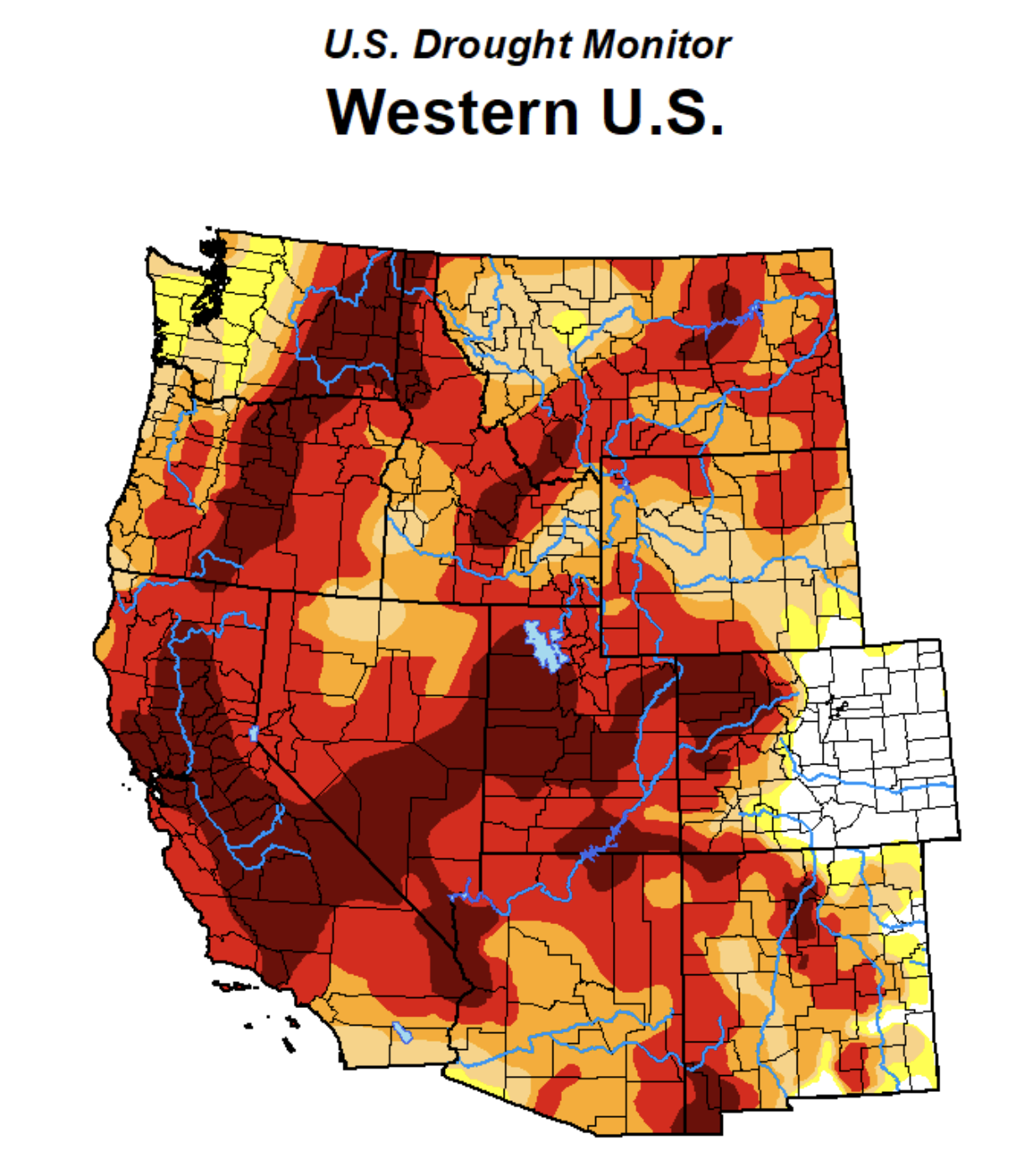
Above average rainfall in southern Utah and southwestern Colorado improved drought conditions by one drought category, but persisted regionally except in Colorado east of the Continental Divide which still remains free of drought. Utah is still experiencing the most severe regional drought conditions, but July precipitation caused some improvement to conditions; D4 drought covers 52% of the state, a 13% reduction during July. In Wyoming, which largely missed the monsoonal rains that Colorado and Utah received, drought conditions worsened during July. Drought conditions now cover 93% of Wyoming and D3 (extreme) drought increased from 9% to 33% of the state during July. While Colorado still remains drought-free east of the Continental Divide, drought conditions generally worsened in western Colorado despite above average precipitation in many locations. D3 drought covers 33% of Colorado and D4 covers 18% of the state.
Image
-
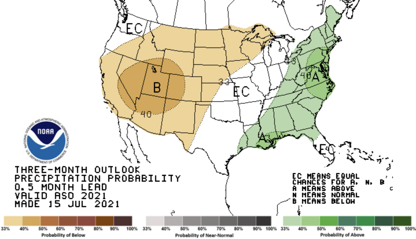
Pacific Ocean temperatures were near-average during July and near-normal ocean temperatures with ENSO-neutral conditions are expected to continue through at least October. NOAA seasonal forecasts on the one-month timescale suggest an increased probability of above average temperatures during August and equal chances of above or below normal precipitation. The NOAA seasonal forecast for August – October suggests and increased probability of below average precipitation
 and above average temperature for the entire region with the highest probabilities centered over Utah, suggesting the possibility of degradation of drought conditions following the monsoonal rains in July.Image
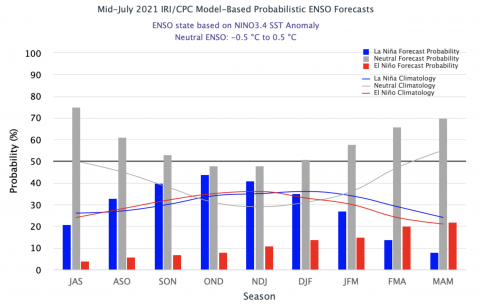 Image
Image
-
Significant July weather event. A flash flood and subsequent debris flow from the Cameron Peak Fire scar killed three people and destroyed five homes in northern Colorado on July 20th. The Cameron Peak Fire, which burned 208,000 acres in 2020, was the largest fire in Colorado state history and left large areas in the mountains of northern Colorado at high risk for debris flows. A monsoonal thunderstorm caused a flash flood and debris flow down Black Hollow into the town of Rustic along the Cache La Poudre River. One of the five homes swept away by the debris flow had four occupants, three of whom were found dead and one remains missing.