November 2, 2022 - CO, UT, WY
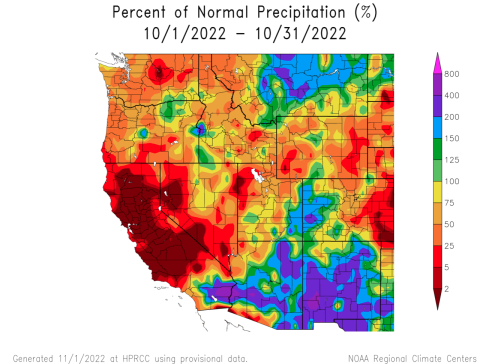
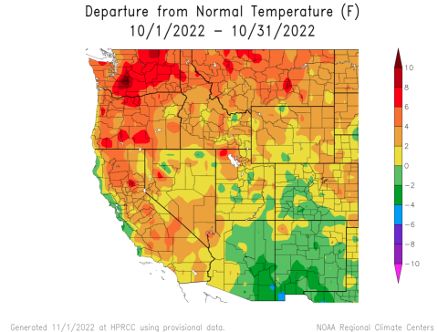
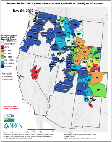
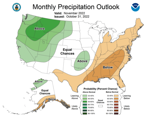
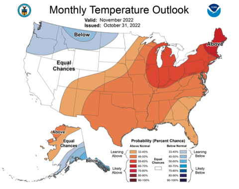
Regional precipitation in October was generally below average, but eastern Utah and western Colorado received above average precipitation. Regional temperatures were near normal in most of Colorado and Utah, but slightly above normal in northern Wyoming, northwestern Utah and northeastern Colorado. Regional snowpack is above to much-above normal in Colorado and Utah, but below normal in Wyoming after a significant late-October storm. Drought conditions expanded slightly to cover 66% of the region with areas of drought developing in southeastern Colorado and eastern Wyoming. La Niña conditions are likely to continue through most of winter, but NOAA precipitation forecasts suggest an increased probability of above average precipitation for much of the region during November.
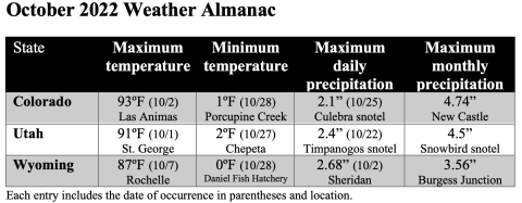
October precipitation was above normal in eastern Utah and western Colorado, but below normal elsewhere. October was a month of weather transitions in the Intermountain West. The first half of the month was dominated by a monsoonal weather pattern. During the first week of October, monsoonal precipitation fell across much of the region. During the second and third weeks of October, a monsoonal weather pattern continued, but precipitation stayed south of the Colorado/Utah border. Dry conditions covered the entire region from October 6-21. The last week of October brought the first major winter storm to the region. Rain fell in many valley locations, but most mountain locations above 7,000 feet received snow (1-3” of snow water equivalent).
After a record hot September in much of the region, October temperatures were relatively cooler. October temperatures in most of Colorado and Utah were within two degrees of average. Temperatures were 2-4 degrees above average in northeastern Colorado, northwestern Utah and northern Wyoming.
The first winter storm of the water year brought widespread snow to regional mountains on October 22-24. Seasonably cool temperatures during the last week of October caused little melting at regional snotel sites. As of November 1st, snow water equivalent (SWE) was much above normal in Utah, near-to-above normal in Colorado and below normal in Wyoming. In Utah, most snotel sites above 8,000 feet are reporting 2-4” of SWE. In western Colorado, most snotel sites are reporting 1-2” of SWE and in Wyoming, few sites have more than 1” of SWE. Note: Current SWE as a percent of normal maps are often skewed at this time of year due to the very low average SWE this early in the season.
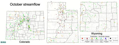
October streamflow in the Upper Colorado River Basin was normal at most locations except part so the White and Yampa River Basins where below normal was observed. Most locations in the Utah portion of the Great Basin experienced below normal October streamflow and many sites saw monthly streamflow less than the 10th percentile. Rivers in Wyoming were generally flowing near normal except for below normal October streamflow conditions along the Snake River. Reservoir storage is below average in Utah; currently, Utah reservoirs are 40% full and average November 1st capacity is 55% full. All major Upper Colorado River Basin reservoirs are also below average capacity with Lake Powell (25% full), Blue Mesa (32%) and Flaming Gorge (72%) near record-low levels of storage.
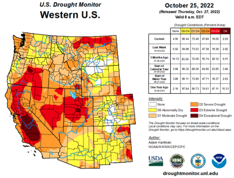
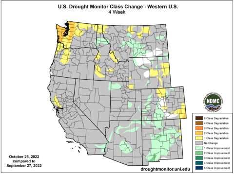
Coverage of drought in the Intermountain West increased slightly to cover 66% of the region. The slight expansion of drought was due to the development of drought conditions in southeastern Colorado and eastern Wyoming. Drought conditions worsened by one category in eastern Wyoming, north-central Colorado and southeastern Colorado. In southeastern Colorado, drought conditions worsened by two categories and severe (D2) drought developed. Small areas of D3 and D4 drought were removed in Utah and drought conditions improved by one category in parts of western Colorado. Northern Wyoming and central Colorado are the only drought-free locations in the western United States.
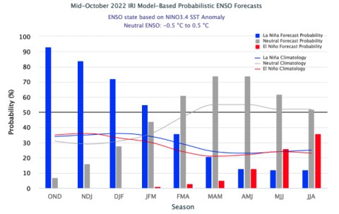
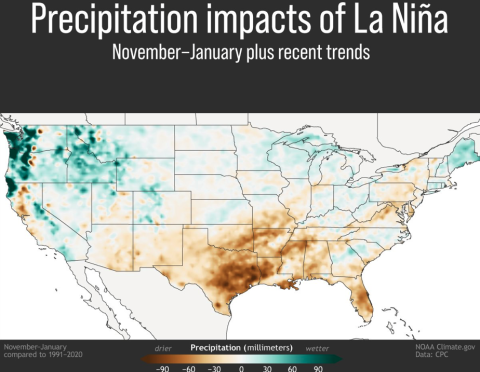
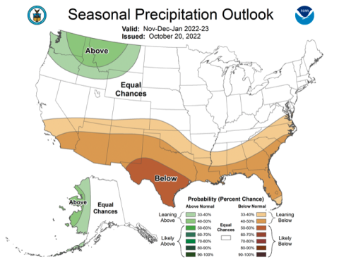
La Niña conditions continue in the eastern Pacific Ocean as sea-surface temperatures are 1-2ºC below normal. There is a 70% probability of La Niña conditions persisting through February and a 55% chance of La Niña through March; By spring, there is greater than a 70% chance of neutral ENSO conditions. In November, there is an increased probability for above average precipitation in Utah, Wyoming and western Colorado and there is an increased probability for above average temperatures in most of Colorado. There are equal chances of above or below average precipitation for most of the region during November through January, but a greater chance of below average precipitation for southern Colorado and Utah. There is an increased probability of above average temperatures for the entire region from November through January.
Significant October weather event. Late October snowstorm impacts entire region. A cold Pacific storm impacted the region from October 22-24 that brought widespread precipitation and significant snow above 7,000 feet. The highest accumulation occurred at Snowbird in the Wasatch Mountains where 27” of snow with 3.3” of SWE accumulated; other locations in the central Wasatch Mountains, Wasatch Plateaus and La Sal Mountains also received significant snow. All snotel sites in Utah received snow from this storm and over 60% of snotel sites received at least 1” of SWE. In Colorado, the snowfall winner was the Bison Lake snotel site in Garfield County with 1.9” of SWE and over 60% of snotel sites received at least 0.5” of SWE. Lewis Lake Divide snotel site in Yellowstone received 2” of SWE from the storm and half of Wyoming snotel sites received at least 0.5” of SWE.
