October 8, 2013
Highlights
- A widespread heavy precipitation event in mid-September caused severe flooding on Colorado’s Front Range but also relieved drought conditions across the region.
- September precipitation was greater than 200% of average over most of the region; it was likely the wettest month across the region in at least five years.
- Many reservoirs, including Lake Powell, experienced gains in storage at a time in the year they are usually declining.
- The NOAA CPC climate outlooks show a dry tilt for Colorado and Utah for the month of October.
Click on the thumbnail images in the text below to bring up the full-sized graphic
September Precipitation and Temperatures, and Current Drought
September ended the 2013 water year on a very wet note across the region, with most of the region receiving at least 200% of normal precipitation, and only a few small areas seeing drier-than-normal conditions . The last month with comparable wet anomalies across the region was December 2007. A persistent rain event from September 9th–17th, caused by a late monsoonal surge from the south reinforced in eastern Colorado by very moist upslope flow, brought most of the month's precipitation, including extraordinary totals for Boulder, Colorado (9" in 24 hours; 17” in seven days) and the surrounding area. (See the WWA’s preliminary assessment of the Front Range rain event and the severe flooding it caused.)
Other areas with over 5” of precipitation for the month included far southeastern Wyoming, south-central Utah, the Uinta Basin in northeastern Utah, the southeastern Yellowstone Plateau, and the San Juans in southwestern Colorado.
With this late surge, the final HPRCC Water Year Precipitation map for 2013 showed that the previously scattered areas with above-average precipitation since October 1 have enlarged and merged, covering perhaps one-third of the three-state region, with the wettest areas in northeastern Colorado, southern Utah, and northern Wyoming. But, as in the 2012 water year, most of the region still ended up drier than normal.
Despite all the precipitation, the temperatures in September were warmer than average across the region, except in parts of western Utah and western Colorado. Most areas were 1–6°F above monthly average temperatures for September.
The latest US Drought Monitor, representing conditions as of October 1 , shows significant and widespread improvement in the persistent drought conditions, by one to three categories, compared to one month ago. The most dramatic improvements were in northeastern Colorado, where up to D2 drought conditions were brought to normal, and in southwestern Colorado, where D3 drought improved to D0 . The proportion of Colorado in D2 or worse drought dropped from 60% on September 3 down to 12% on October 1; in Utah, 54% down to 16%; and in Wyoming, 48% to 22%. Region-wide, the overall drought extent and severity is now lower than it has been since April 2012.
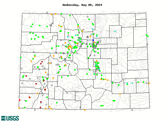
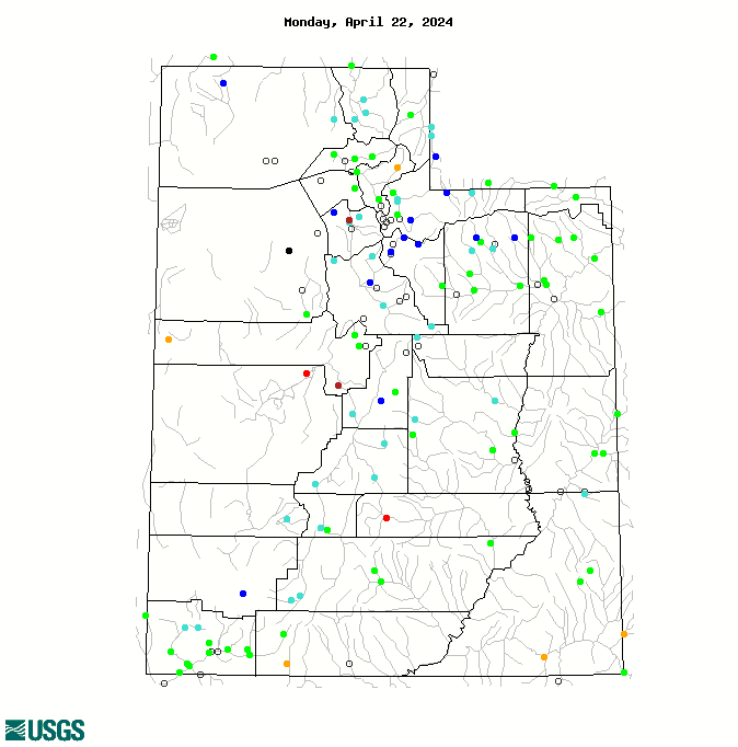
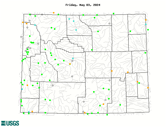
Current Streamflows
As with the other hydroclimatic indicators, the maps of current streamflows for Colorado , Utah , and Wyoming clearly show the effect of the prodigious September precipitation. In Colorado and Wyoming, there are many gages in the much above normal (dark blue) and high (black) categories, and relatively few in the below-normal categories. Utah has a more equitable distribution across the flow categories. The Colorado River near the CO-UT state Line was in the 64th percentile (118% of median flow) on October 5.
Aided by very high flows on the San Juan River, Lake Powell received inflows of 0.86 MAF in September, over 200% of the average inflows for September, and over twice the combined inflows in July and August this year. As a result, the final water year inflows to Powell should come in closer to 5.0 MAF (47% of average), versus the 4.3 MAF projected at the beginning of September.
Reservoir Storage
The well-above-average precipitation in many parts of the region provided an unexpected but welcome boost to reservoirs at a time of year they are typically dropping towards their winter-early spring low stands. In the flooding-affected drainages of Colorado’s Front Range, several small to mid-size (<50 KAF) reservoirs filled and spilled, while large reservoirs in western Colorado saw well-above-average inflows and gains in storage, including Dillon, Blue Mesa and Navajo Reservoirs.
On September 30, Lake Powell held 10.93 MAF (45% full), up from the 10.79 MAF held on August 31, and more significantly, well above the 10.5 MAF (43% full) projected in early September as the end-of-water-year contents. The surface elevation of Powell on September 30 was 5 feet higher than had been projected three weeks earlier.
Seasonal Climate and Drought Forecasts
The latest monthly Climate Outlook released on September 30 by NOAA CPC show a dry tilt for precipitation for October covering all of Colorado and Utah, and southern Wyoming. The seasonal outlooks released September 19 show a slight tilt towards wetter conditions in far northern Wyoming, but no tilt elsewhere in the region, for the October–December period , and a slight wet tilt in northern Wyoming and a slight dry tilt for southern Colorado and Utah for the November–January period . The CPC Climate Outlooks once again show enhanced odds for above-normal temperatures for the upcoming seasons , consistent with long-term warming trends. The latest CPC Seasonal Drought Outlook released September 19 projects that drought conditions over most of our region, though much improved last month, will persist through at least December, with no additional improvement expected.
The PSD Precipitation Forecast Guidance ("SWcast") released September 11 for October–December 2013 conditions shows a slight wet tilt for the period for far northeastern Colorado, and a dry tilt for most of eastern Colorado into the northern Front Range. No tilt is forecasted for the rest of Colorado and Utah, indicating equal chances for wet, dry, and middle outcomes. The fall-early winter period historically has shown the least forecast skill of all seasons, though there has been positive skill east of the Continental Divide.
Klaus Wolter of NOAA PSD has also issued the first experimental January 1 SWE forecast for Colorado, with separate forecasts for the seven state water divisions, which follow the major river basins. The median (50th percentile) forecast calls for above-average January 1 snowpack (109–117% of average) for all basins except the Yampa (93%) and Rio Grande (98%).
Stop us if you've heard this one before: ENSO indicators continue to show ENSO-neutral conditions, as they have for the past 12 months. The models in IRI's mid-September ENSO Prediction Plume again indicate a consensus towards ENSO-neutral conditions continuing through the fall and early winter, with the dynamical models tending towards the warm side of neutral, and the statistical models tending to stay on the cool side.