May 12, 2021 (UT, WY, CO)
-
May - July streamflow volumes are forecasted to be less than 60% of average in the Upper Colorado River Basin and less than 50% of average in the Great Basin. The May - July inflow of Lake Powell is forecasted to be 28% of normal. Regional precipitation in April was below average and temperatures were slightly below average. Parts of western Colorado recorded a record dry April. Drought covers 90% of Colorado, Utah and Wyoming and seasonal forecasts predict a higher probability for below average precipitation and above average temperature for the next three months which suggests persistence and, potentially, worsening of drought. Wetter conditions with near-to-above normal snowpack and seasonal streamflow conditions and improvements to drought conditions exist in northern Wyoming.
-
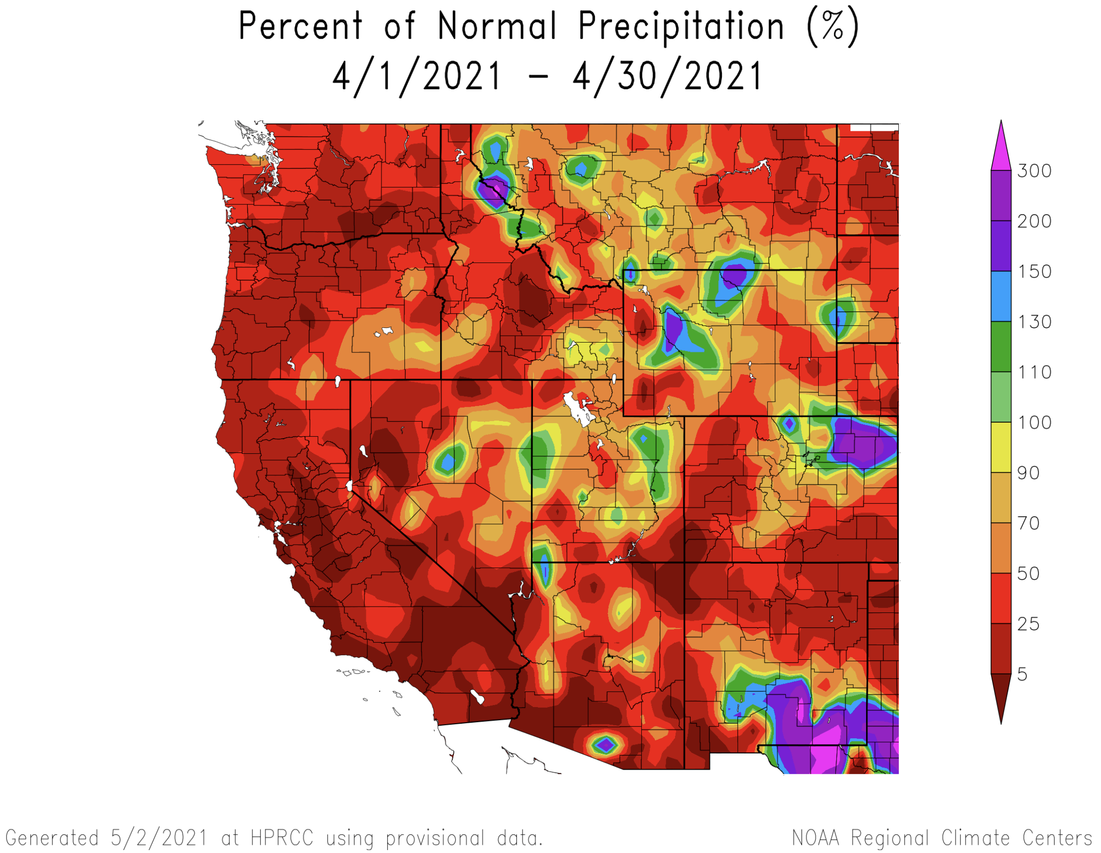
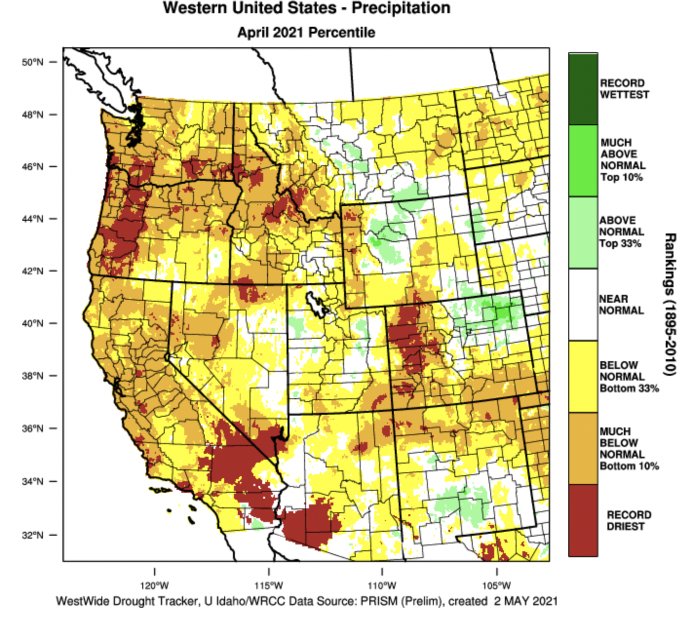
April precipitation was generally below normal throughout the region. In Colorado, the western and southeastern portions of the state received less than 50% of normal April precipitation, but northeastern Colorado saw above average precipitation. For a large area in western Colorado, April 2021 was the driest April on record. In Utah and Wyoming, approximately half of each state received less than 70% of normal April precipitation and pockets of above average precipitation were scattered throughout each state.
Image Image
Image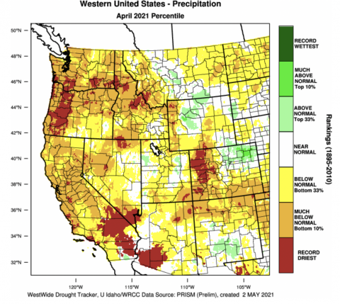
-
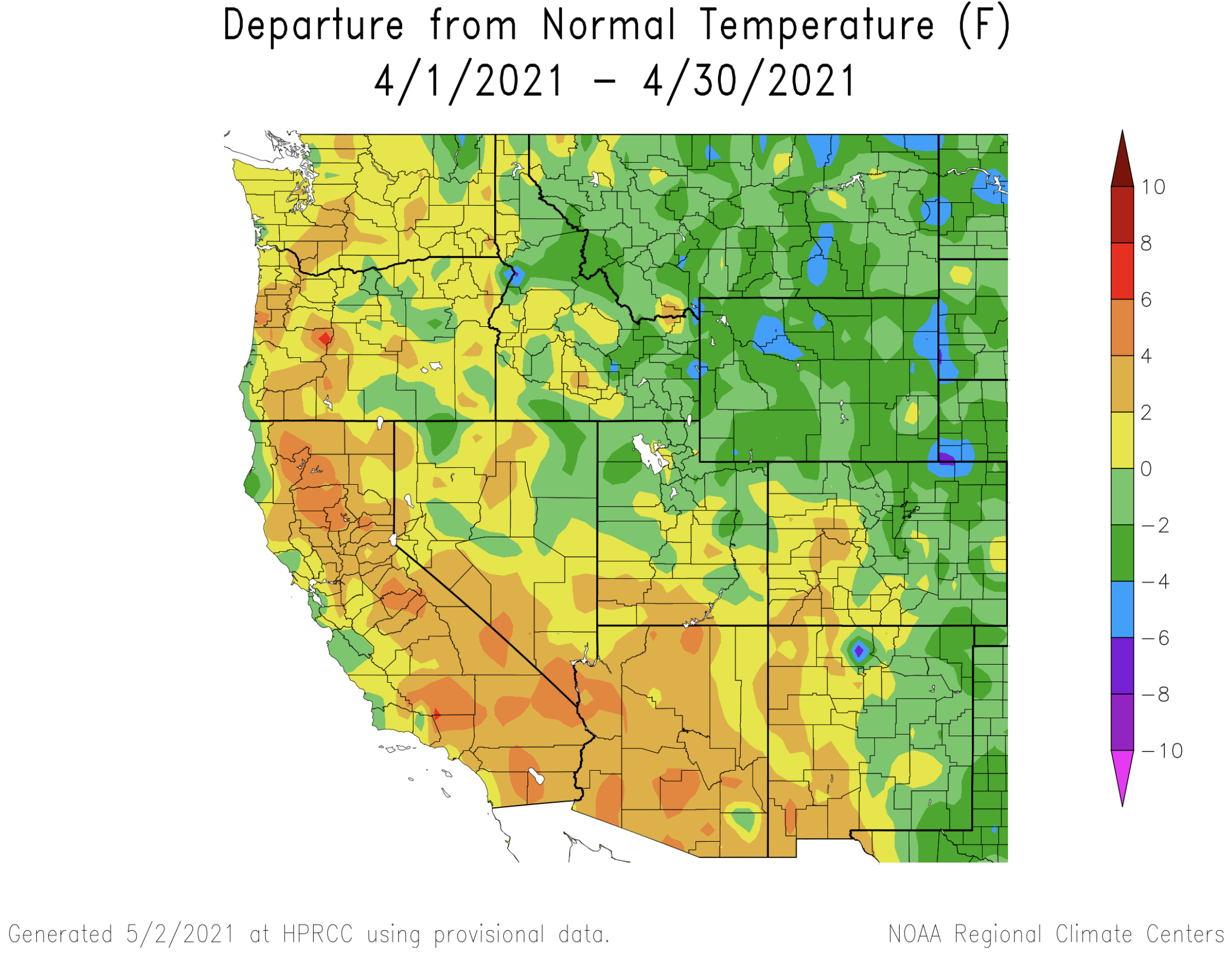
Temperatures were near normal in Utah and most of Colorado during April and below normal in Wyoming. In Wyoming, April temperatures were below normal, with much of the state seeing temperatures 2-4 degrees cooler than average. The warmest regional temperatures during April were in southern Utah and southwestern Colorado.
Image
-
May 1st snowpack conditions range from above average snow-water equivalent (SWE) in northeastern Wyoming to much below average SWE in southwestern Utah. The gradient of above average snowpack in the northeastern portion of the region to much below average snowpack to the southwest likely reflects a combination of snowfall patterns during winter and temperature patterns during April. In Colorado, SWE is less than 70% of normal except for the North and South Platte River basins. Snowpack conditions are much worse in Utah with May 1st SWE at 50-60% of normal for northern Utah and less than 50% of normal for southern Utah. May 1st snowpack for the northeast half of Wyoming ranges from 100 – 130% of average and SWE in the southwest half of the state is 70-80% of average.
Image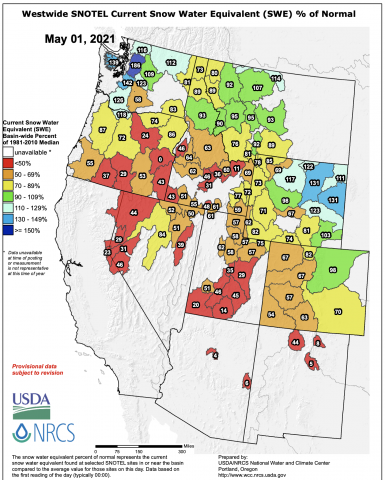
-
Seasonal streamflow volume forecasts for May 1st by NOAA CBRFC much below average in the Upper Colorado River and Great Basins. Streamflow is forecasted to be below 60% of normal for the entire Upper Colorado River basin and streamflow forecasts generally decreased by 10-20% since April 1st. In the Great Basin, seasonal streamflow is forecasted to be less than 50% and forecasted streamflow volumes decreased by 5-15% since April. East of the Continental Divide, seasonal streamflow forecasts are closer to normal. The Arkansas River basin is forecasted to have 70-80% of average seasonal streamflow and the South Platte River is forecasted to be 75-90% of normal. May 1st seasonal streamflow forecasts for the inflow of major reservoir is also much below average with Lake Powell at 28% of average, Flaming Gorge Reservoir at 45% of average and Navajo Reservoir at 45% of average.
Image Image
Image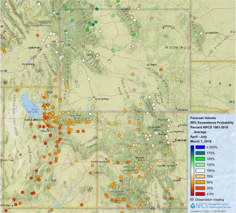
-
Drought conditions continue across over 90% of the region with 40% of the region in extreme (D3) or exceptional (D4) drought. Drought remains most severe in Utah where the entire state is in drought and all but extreme northern Utah is in D3-D4 drought. Drought conditions changed the most in Wyoming during April. Drought developed in western Wyoming but improved in many other portions of the state. In central Wyoming, the area of D3 drought significantly contracted and D3 drought now covers only 6% of the state, compared to 18% of the state in late March. Drought removal occurred in a portion of northern Wyoming and D2 drought in eastern Wyoming also contracted. Drought conditions in Colorado remained largely unchanged except for a moderate expansion of D4 conditions in western Colorado and the removal of drought in portions of Boulder, Larimer and Weld Counties.
Image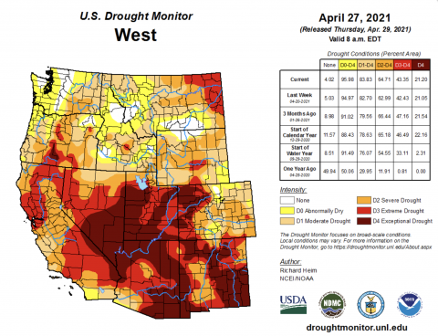
-
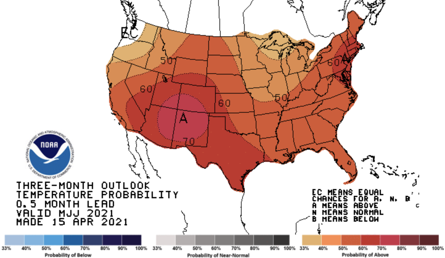
La Niña conditions present throughout the winter continue to weaken and mid-April eastern Pacific Ocean temperatures were 0.4º C below normal. There is nearly an 80% probability of neutral ENSO conditions during April – July. NOAA seasonal forecasts at the one- and three-month timescale suggest that regional drought conditions will certainly persist and likely worsen. The NOAA precipitation outlook for May - July predicts an increased probability of below average precipitation for nearly the entire region with a 50-60% chance of dry conditions in northwestern Wyoming. There is at least a 50% probability of above average temperatures for the entire region during May – July with a 70% probability of above average temperatures for the Four Corners region.
Image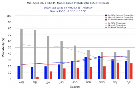 Image
Image Image
Image
-
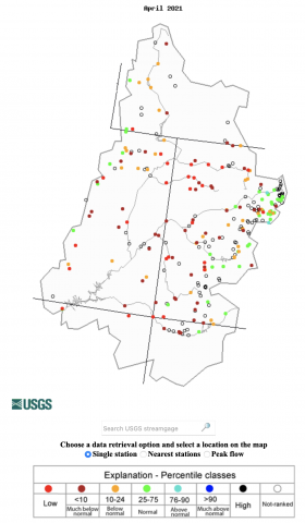
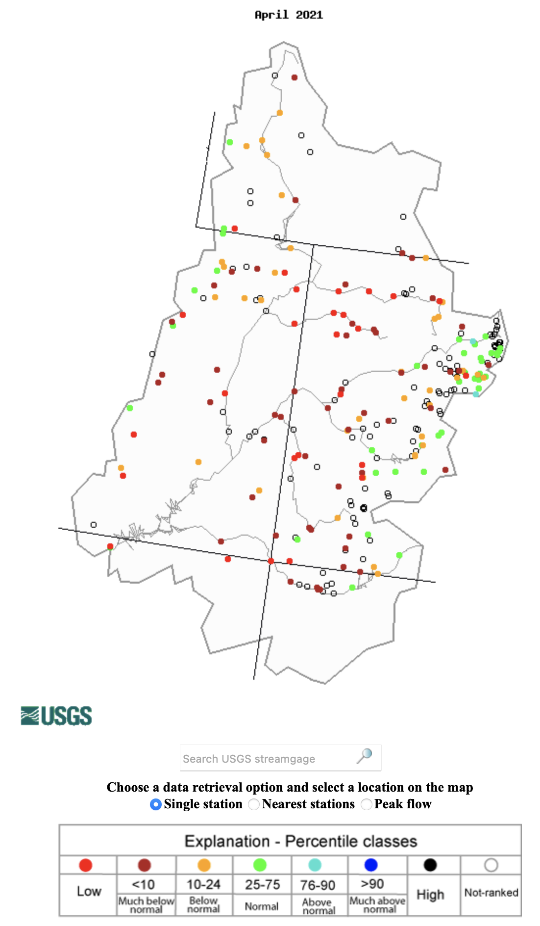
Significant April weather event. Extremely low streamflow was observed in Utah and Colorado during April. Record low April streamflow was observed at 16 river gages in Colorado and 13 gages in Utah. Despite slightly worse drought conditions in the Great Basin compared to the Upper Colorado Basin, record low streamflow was observed at only 5 Great Basin sites compared to 26 sites in the Upper Colorado River Basin. Notable rivers where record low April streamflow was observed include the Yampa River (4 sites), White River (3 sites), Mainstem Colorado River and Lower Green River (2 sites).
Image