March 11, 2020 (UT, WY, CO)
- Despite a relatively dry February and a dry start to March, the snowpack in most of the region remains near normal. Below-average (70-90%) spring-summer streamflow is forecasted for much of the region, while near-average streamflow is forecasted in northern Utah, above-average streamflow is forecasted for the Colorado Headwaters and Yampa River basin, and much-below-average streamflow is forecasted for the San Juan River basin. Drought conditions across the region have changed little in the last month.
- February precipitation was below- to much-below-normal for most of Utah and southwestern Colorado. Northwest and central Wyoming and northern and eastern Colorado saw normal to much-above-normal precipitation. On a statewide basis, Utah saw below-average precipitation, Colorado saw near-average precipitation and Wyoming saw above-average precipitation. February temperatures were near average or below average for much of the region with northern Colorado and Wyoming experiencing the coldest conditions relative to normal. Temperatures across Wyoming were at least 2 degrees F below normal and a large portion of central Wyoming and northern Colorado was 6 to 10 degrees F below normal.
- The snowpack throughout the Intermountain West is generally near normal to slightly above normal as of March 11th. Despite below-average February precipitation, the snowpack remains near-normal in all but one Utah basin. In Wyoming, snowpack is near-normal in the western half of the state and slightly above normal in eastern Wyoming. In Colorado, the snowpack is generally above normal in the north and near normal in the south, except for the San Juan River basin, which is at 84% of median SWE. As a whole, the Upper Colorado River Basin has near-normal snow conditions with 102% of median SWE as of March 11th.
- The NRCS and NOAA CBRFC March 1 seasonal runoff forecasts generally call for below-average runoff for the region except along the mainstem of the Colorado River and the Yampa River (100-130% of average). March 1 streamflow forecasts for much of Utah and the upper Green River basin call for 70-90% of average runoff, except the for Bear River, Six Creeks and San Rafael Rivers where near-average streamflow is forecasted. Much-below-average (50-70%) streamflow is forecasted for the San Juan River basin. The inflow to Lake Powell is forecasted to be 80% of average by CBRFC, and 78% of average by NRCS, despite overall near-normal snowpack conditions for the Upper Basin. A very dry summer over most of the region caused generally low antecedent soil moisture conditions, which are expected to lead to less efficient runoff in many basins.
- According to the March 3rd US Drought Monitor, Wyoming is nearly free of drought conditions, while nearly 60% of Utah and 45% of Colorado are classified as D1 or D2 drought. After a very wet winter and spring wiped out drought conditions in our 3-state region by June 2019, drought reemerged by the start of the 2020 water year. Over the past month, drought conditions have improved in southwestern Wyoming and parts of northwestern and central Colorado. Areas of D0 and D1 drought expanded further westward in central Utah where little to no precipitation fell in February.
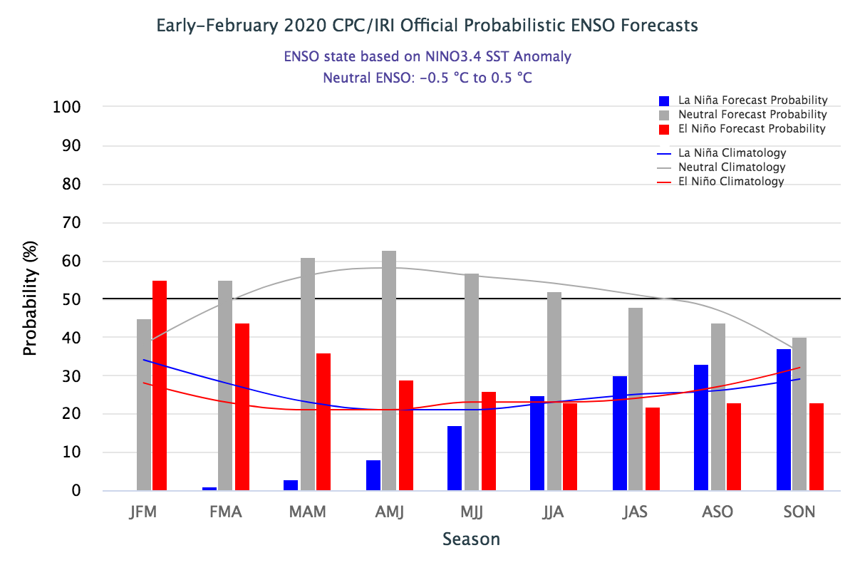
- Temperatures in the tropical Pacific Ocean were warmer than average in January and February, but ENSO-neutral conditions have persisted and are forecasted to persist through the rest of spring 2020. Sea-surface temperatures are forecasted to cool by summer , so ENSO-neutral conditions will likely continue . The NOAA CPC temperature and precipitation outlooks for March show no shift from climatological odds for Colorado, Utah, and Wyoming for March. The three-month outlook shows a slight tilt towards above-average normal precipitation in Wyomingand a stronger tilt towards above-normal temperatures for most of the region, with the greatest chance of above-normal temperatures in the already-dry Four Corners region.
- Significant regional weather event in February: On February 7-8, a warm storm system dropped 30-41” of snow containing 5-7” of SWE in Little Cottonwood Canyon in Salt Lake County, Utah. The 48-hour storm event triggered a historic avalanche cycle that closed Little Cottonwood Canyon for over two days. During the storm, all major south-facing avalanche paths and many infrequently-running paths let loose, with more than a dozen avalanches crossing the highway, leaving debris piles up to ten feet deep that entrained trees up to a foot in diameter.