July 13, 2021 (UT, WY, CO)
-
During June, extremely high temperatures in Utah and Wyoming fueled the persistence of drought and drought expansion in northern Utah and northern Wyoming. A surge of monsoonal moisture caused above average precipitation in southwestern Colorado. Seasonal streamflow volume in nearly all of the region’s rivers was extremely low in 2021. Most Intermountain West rivers, except for those east of the Continental Divide in Colorado, saw near-record low streamflow volume.
-
An early push of monsoonal moisture northward into Colorado led to much above average precipitation in southwestern and central Colorado. Much of southwestern and south-central Colorado received nearly double the average June precipitation and localized areas received up to four times the average June rainfall. June precipitation was below normal for nearly all of Utah with most of the state seeing less than 50% of average precipitation. In Wyoming, the Great Divide Basin received near-normal precipitation but the rest of the state saw below average rainfall with the least precipitation occurring in western Wyoming.
Image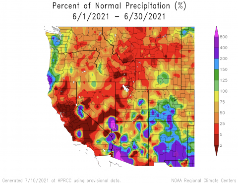
-
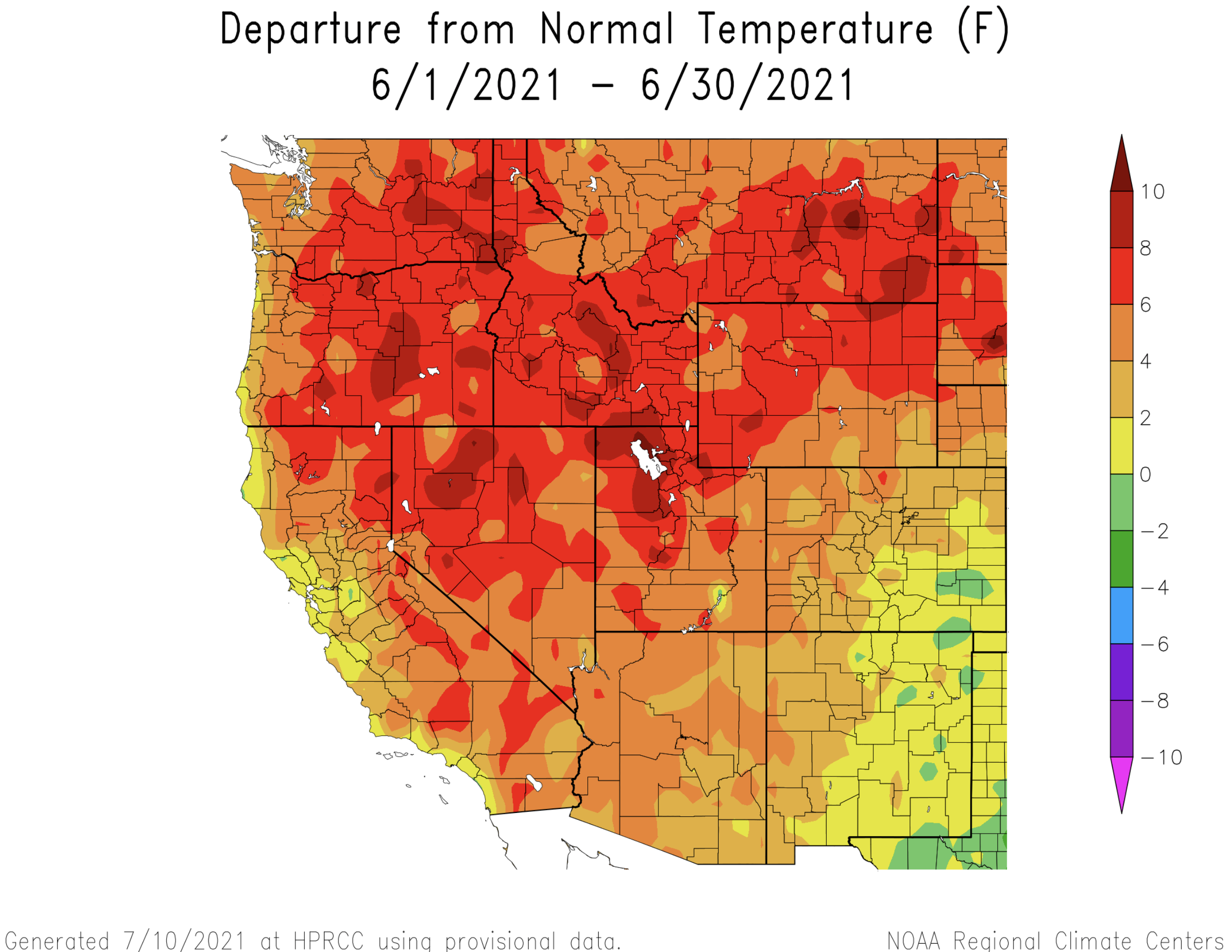
Temperatures during June were much above normal in Utah and Wyoming. Temperatures were at least 4 degrees above normal and large areas of both states experienced temperatures that were 6 – 8 degrees above normal. Along the Wasatch Front and in Great Salt Lake Basin of Utah, temperatures were up to 10 degrees above normal. For many areas along the Wasatch Front, including Salt Lake City, June 2021 was the hottest June on record. In Colorado, temperatures were generally 2 – 6 degrees above normal except for southeastern Colorado where temperatures were near-normal.
-
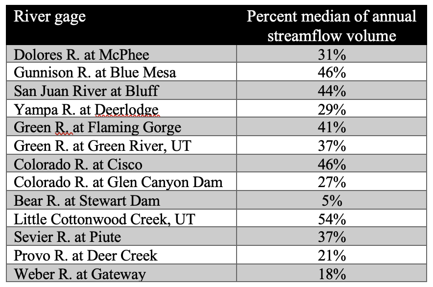
Streamflow in most rivers around the region returned to baseflow conditions by late June, a time when rivers are typically still flowing high with snowmelt. During June, streamflow in much of the region was extremely below normal with many stream gages reporting June streamflow in the bottom 10th percentile. With the majority of annual streamflow volume having occurred, nearly all rivers in the region saw less than 50% of normal streamflow volume. The lowest streamflow volumes observed for the 2021 water year were in northern Utah, on the Dolores River and the Colorado River at Glen Canyon Dam. This table shows percent of median annual streamflow volume for the 2021 water year through July 12th. Regional annual streamflow volume is near or just above record low levels at most locations, except for rivers east of the Continental Divide in Colorado which are much closer to normal.
Image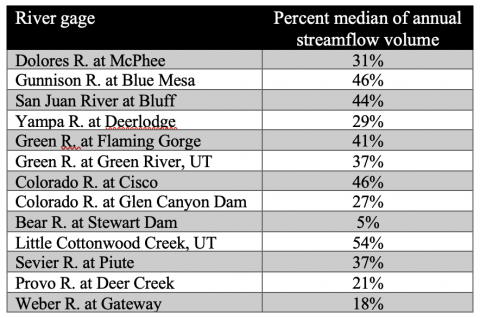
-
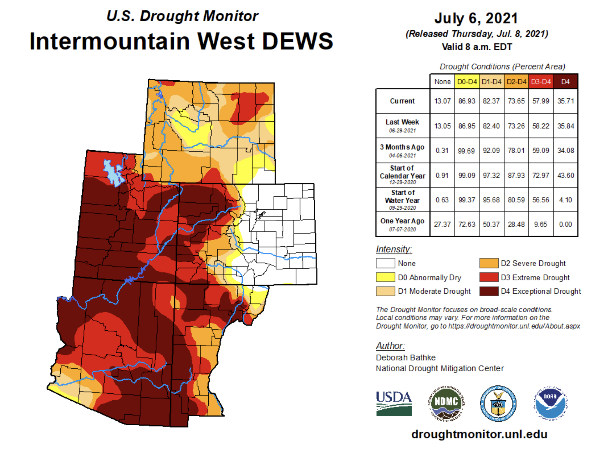
Drought conditions remain in place over the entire region except in Colorado east of the Continental Divide. Drought conditions degraded in northern Utah and northern Wyoming during June. Utah and western Colorado are most severely impacted by the current drought. Much of the West Slope of Colorado is experiencing extreme (D3) or exceptional (D4) drought and in Utah, D3 and D4 drought covers 98% of the state.
Image
-
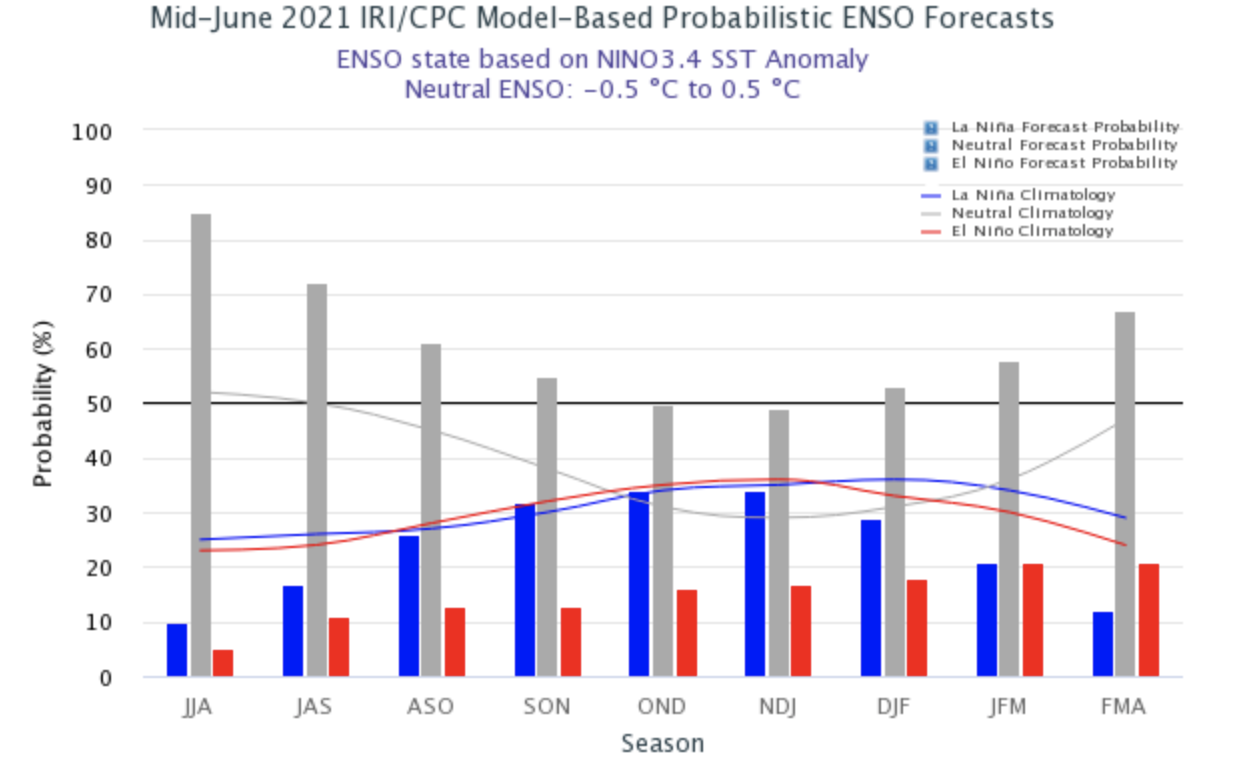
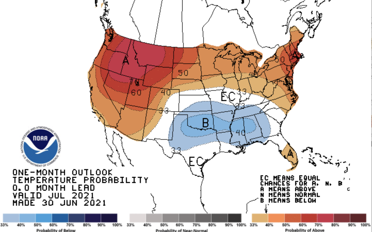
ENSO conditions are currently neutral with Pacific Ocean temperatures near average and neutral ENSO conditions are expected to continue through fall. NOAA seasonal forecasts suggest an increased probability of above average precipitation during July in southern Utah and southern Colorado, suggesting a surge of monsoonal moisture. In July, there is a very high probability of above average temperatures in northern Utah and a slightly higher probability of above average temperatures for the rest of the region. During August through October, there is an increased probability of above average temperatures and below average precipitation for the entire region.
Image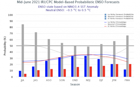 Image
Image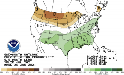 Image
Image

-
Significant June weather event. A record-shattering heat wave covered the Intermountain West during mid-June. From June 13-19, record high temperatures were reached throughout Colorado, Utah and Wyoming, including several all-time record high temperatures. The mid-June heat wave was particularly notable because of how early in the summer it occurred. In Colorado, Cortez and Alamosa had record high temperatures on 6 consecutive days and Cortez tied its all-time high of 102°F on two days. Grand Junction saw record high temperatures on three consecutive days; record high temperatures were also observed in Colorado Springs, Denver, Pueblo and Steamboat Springs. Salt Lake City observed three consecutive days of triple digit temperatures that broke daily records, including tying the all-time record high of 107°F on June 15th. Cheyenne, Riverton and Sheridan, Wyoming all saw record high daily high temperatures. Sheridan tied the all-time record high of 107°F also on June 15th.