April 8, 2021 (UT, WY, CO)
-
A large upslope storm led to above average March precipitation in eastern Colorado, eastern Utah and southeastern Wyoming. Drought conditions east of the Continental Divide generally improved by one category and many river basins in these areas have near normal seasonal runoff forecasts. March was dry for much of the Upper Colorado River and Great Basins, drought conditions persisted and seasonal runoff forecasts are below to much-below normal.
-
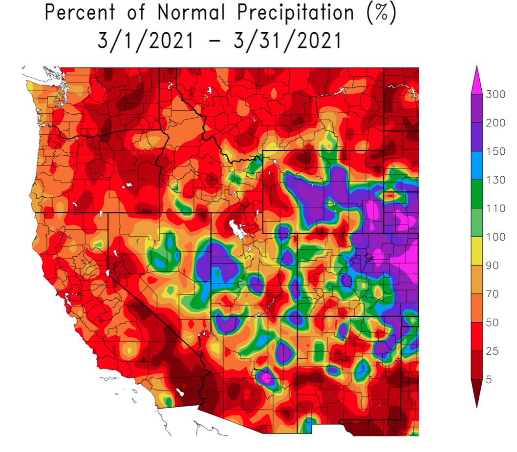
Precipitation was a mix of much-above normal and below normal during March. Much-above normal precipitation in eastern Colorado, southeastern and central Wyoming and eastern Utah was driven largely driven by a large upslope storm in Colorado in mid-March. Below normal precipitation fell in many areas of Utah, including the Wasatch and western Uinta Mountains, western and northern Wyoming and the Colorado Rocky Mountains west of the Continental Divide.
Image
-
Regional temperatures during March were mostly near average. There was a slight southwest to northeast gradient in regional temperatures with March temperature slightly below normal in southwestern Utah and slightly above normal in northeastern Wyoming. This pattern in monthly temperatures is the opposite from what was observed in November 2020 and February 2021.
Image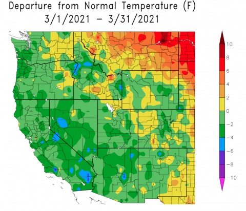
-
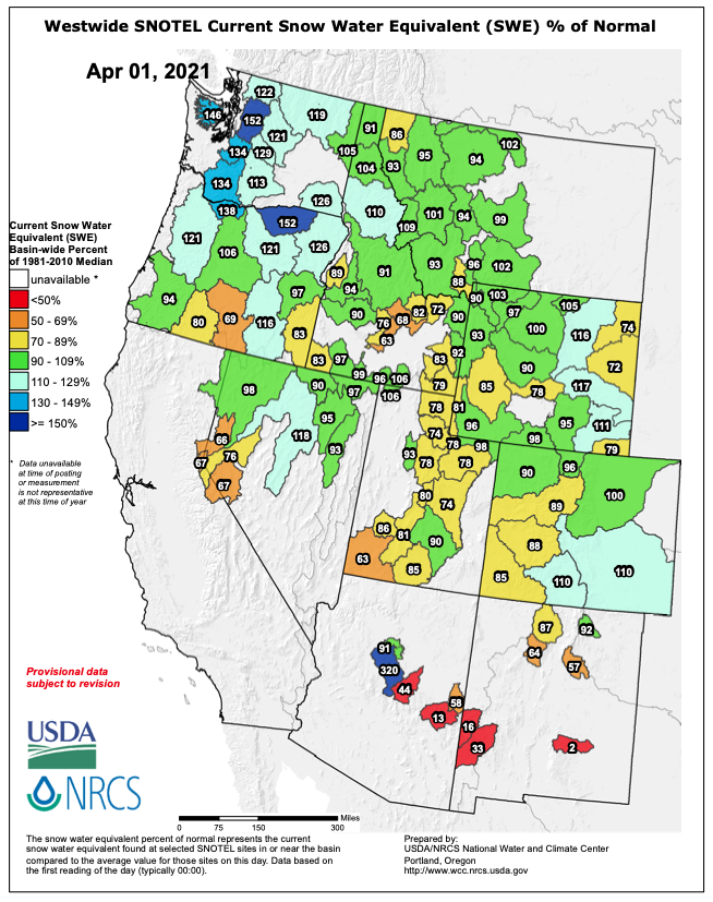
April 1st snowpack conditions were a mix of above and below normal in Colorado and Wyoming and generally below normal in Utah. There was below normal snowpack in southwestern Colorado, near normal in northern Colorado and above normal conditions in the Rio Grande and Arkansas River basins. Except for the northeastern Uinta Mountains, where conditions were near normal, Utah snowpack was below normal. Snowpack in eastern Wyoming benefitted from a large upslope storm in mid-March and was above average on April 1st. Snowpack conditions in other areas of Wyoming were generally near normal.
Image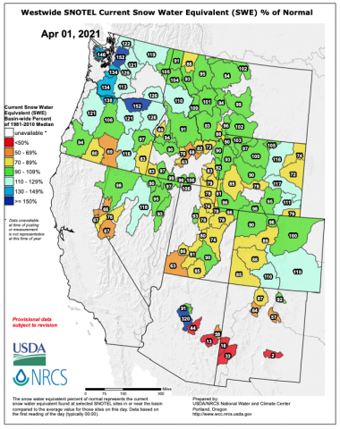
-
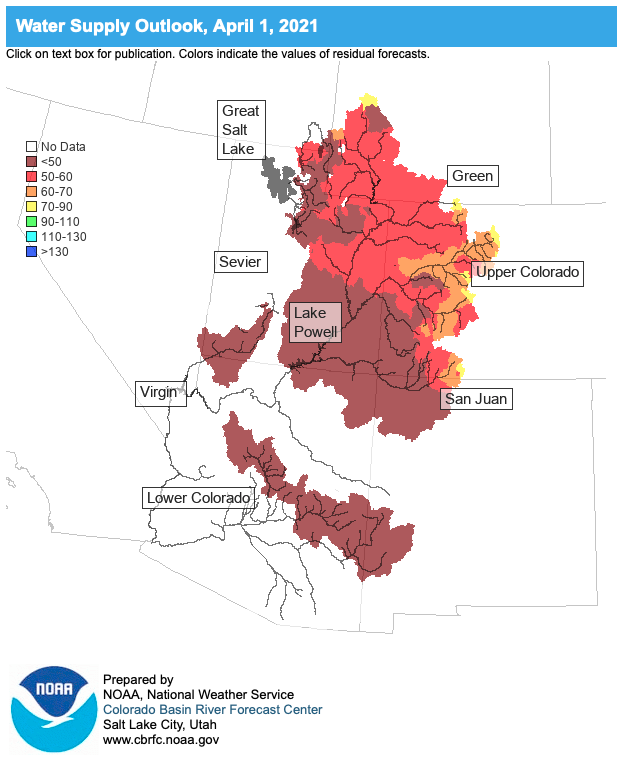
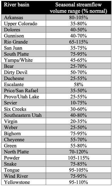
Seasonal streamflow volume forecasts for April 1st by NOAA CBRFC were below normal to much-below normal for the entire Upper Colorado (25 – 80% normal) and Great Basins (10 – 75%). Low seasonal streamflow forecasts are due to below average snowpack for most basins and extremely low soil moisture. Because of very low soil moisture across the region, the 2021 runoff will be an inefficient runoff. Regionally, the lowest seasonal runoff forecasts are for Utah river basins (Duchesne, Provo, Virgin and Weber) and the highest are for river basins in Colorado and Wyoming east of the Continental Divide. (Forecast by basin_040121) Major reservoirs of the Upper Colorado River Basin are forecasted to have below normal inflow for Fontanelle (59%), Flaming Gorge (54%), Blue Mesa (65%), McPhee (44%), Navajo (54%) and Lake Powell (45%). Streamflow during March was much below normal for much of the region and record low monthly streamflow was observed for the siteas along the American Fork, Bear, Dolores, Sevier, Virgin and Weber Rivers in Utah and the Animas, Dolores, Mancos, Roaring Fork, and San Miguel Rivers in Colorado.
Image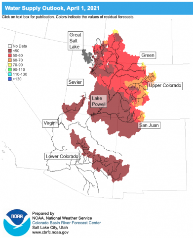 Image
Image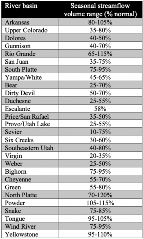 Image
Image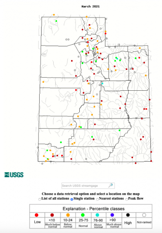 Image
Image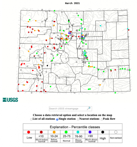
-
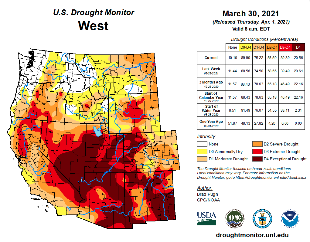
Drought conditions continue to cover nearly the entire Intermountain West with 44% of the region in extreme (D3) or exceptional (D4) drought, but there was a one category improvement of drought conditions in eastern Colorado and Wyoming. Drought conditions did not change in Utah during March; 90% of the state is still in D3 or D4 drought. A strong upslope storm on March 13-14th dropped several inches of SWE across a wide swath of Colorado east of the Continental Divide and eastern Wyoming. At the beginning of March, D3 or D4 drought covered 60% of Colorado, but by the end of March, only 30% of the state was in D3-D4 drought.
Image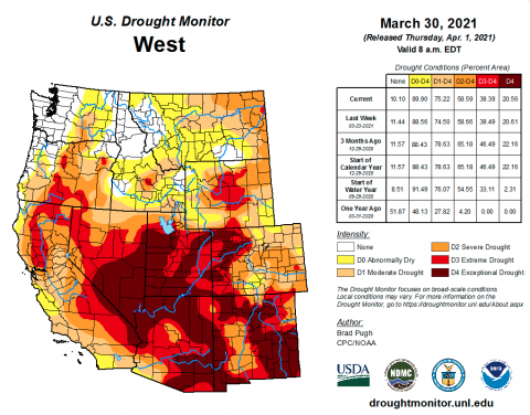
-
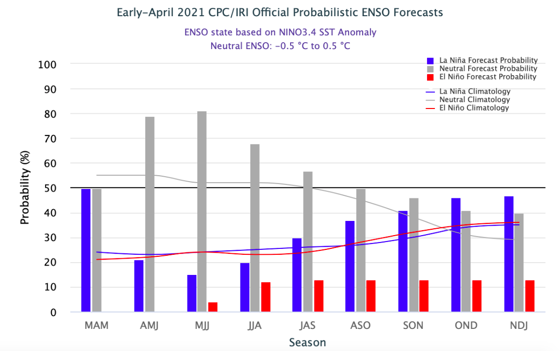
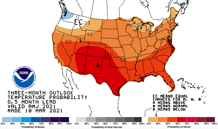
Weak La Niña conditions still exist in the eastern Pacific Ocean, but neutral conditions are expected to return during spring. Seasonal predictions of climate from NOAA suggest there will be an increased probability for above average temperatures and below average precipitation at one and three month timescales for the entire region. The increased probability of above average temperatures and below average precipitation will likely cause drought conditions in the Intermountain West to persist and perhaps worsen.
Image Image
Image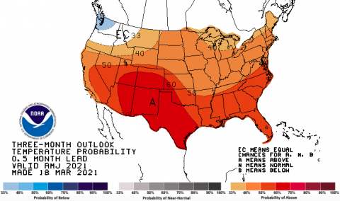 Image
Image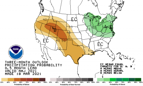
-
Significant March weather event. A significant upslope snowstorm hit the Front Range of Colorado and southern Wyoming on March 13-14th. Snowfall totals from Colorado Springs to Cheyenne Wyoming and west to the Continental Divide ranged from 18 - 40”. Denver International Airport reported 27.1”, making this storm the 4th largest snowfall in Denver since 1881. Cheyenne recorded a 36” storm total; 22.7” fell on 3/14 which broke the daily snowfall record for Cheyenne. The highest storm totals occurred in southeast Wyoming’s Snowy Range at 7,900 feet where 52.5” fell and in the foothills north and west of Fort Collins at Buckhorn Mountain where 48.5” was recorded. The storm closed Denver International Airport and 2,800 flights were canceled on March 13-15. Parts of Interstates 25 and 70 in Colorado and I-80 in Wyoming were also closed on 3/13-14. Approximately 25,000 customers lost power in northern Colorado as a result of the storm. Nearly all of Colorado and Wyoming were in drought prior to the storm, with large areas of both states in extreme drought. The storm did not bring an end to drought, but significantly improved drought conditions east of the Continental Divide in Colorado and in southern Wyoming.